East Area 2 Annexation Project Information - City of Santa Paula
East Area 2 Annexation Project Information - City of Santa Paula
East Area 2 Annexation Project Information - City of Santa Paula

You also want an ePaper? Increase the reach of your titles
YUMPU automatically turns print PDFs into web optimized ePapers that Google loves.
RevisedNotice <strong>of</strong> PreparationTo:From:Responsible and Trustee Agencies and others on attached distribution list<strong>City</strong> <strong>of</strong> <strong>Santa</strong> <strong>Paula</strong>200 South Tenth Street.<strong>Santa</strong> <strong>Paula</strong>, California 93060Subject: Notice <strong>of</strong> Preparation <strong>of</strong> a Draft Environmental Impact Report<strong>East</strong> <strong>Area</strong> 2 <strong>Annexation</strong> <strong>Project</strong>The <strong>City</strong> <strong>of</strong> <strong>Santa</strong> <strong>Paula</strong> will be the Lead Agency and will prepare an Environmental Impact Report (EIR)for the <strong>East</strong> <strong>Area</strong> 2 <strong>Annexation</strong> <strong>Project</strong>. The <strong>City</strong> seeks public input on the content <strong>of</strong> the EIR, which isgermane to your agency’s statutory responsibilities in connection with the proposed project. Your agencymay need to use the EIR prepared by our agency when considering your permit or other approvals forthe project.The project description, location, and the probable environmental effects are described in the attachedmaterials. A copy <strong>of</strong> the Initial Study (is is not ) attached.The <strong>City</strong> circulated a Notice <strong>of</strong> Preparation for this EIR on July 20, 2011. Based on consultation withVentura County Local Agency Formation Commission (LAFCo) staff during the NOP review period,revisions to the proposed General Plan and zoning designations for a portion <strong>of</strong> the annexation area havebeen made, as further described in the attached materials. This revised NOP is being circulated to allowfor comments on this change to the proposed project. Due to the time limits mandated by state law, yourresponse must be sent to the <strong>City</strong> by September 29, 2011.Please send your response to Ms. Janna Minsk, Planning Director, <strong>City</strong> <strong>of</strong> <strong>Santa</strong> <strong>Paula</strong>, PO Box 569, <strong>Santa</strong><strong>Paula</strong>, California 93061. Please provide the name <strong>of</strong> a contact person at your agency. You may also emailyour response to: jminsk@spcity.org .<strong>Project</strong> Title:<strong>East</strong> <strong>Area</strong> 2 <strong>Annexation</strong> <strong>Project</strong>Date:Signature:Janna Minsk, AICPTitle: Planning DirectorTelephone: (805) 933-4214Reference: California Administrative Code, Title 14 (State CEQA Guidelines), Sections 15082(a), 15103, 15375.. 1 <strong>East</strong> <strong>Area</strong> 2 <strong>Annexation</strong> <strong>Project</strong>August 2011
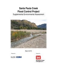
PROJECT LOCATION AND DESCRIPTIONEAST AREA 2 ANNEXATION PROJECTThe <strong>City</strong> <strong>of</strong> <strong>Santa</strong> <strong>Paula</strong> is proposing to annex portions <strong>of</strong> the <strong>East</strong> <strong>Area</strong> 2 Planning <strong>Area</strong> as designated inthe <strong>City</strong>’s General Plan. The annexation project includes a series <strong>of</strong> related actions, including amendment<strong>of</strong> the General Plan Land Use Element and pre-zoning <strong>of</strong> the annexation area. In addition, adoption <strong>of</strong> the<strong>Santa</strong> <strong>Paula</strong> <strong>East</strong> Gateway Specific Plan is proposed for a portion <strong>of</strong> the annexation area. The location <strong>of</strong>the <strong>East</strong> <strong>Area</strong> 2 <strong>Annexation</strong> <strong>Area</strong> in relation to the <strong>City</strong> <strong>of</strong> <strong>Santa</strong> <strong>Paula</strong> is shown in Figure 1. <strong>East</strong> <strong>Area</strong> 2 islocated on the northeast edge <strong>of</strong> the <strong>City</strong> <strong>of</strong> <strong>Santa</strong> <strong>Paula</strong>.Figure 2 shows the boundary <strong>of</strong> the area proposed for annexation. The proposed annexation areaincludes the existing unincorporated island located south <strong>of</strong> State Route 126 and north <strong>of</strong> LemonwoodDrive, the area located to the east <strong>of</strong> the current city limits between State Route 126 and the <strong>East</strong> <strong>Area</strong> 1Specific Plan <strong>Area</strong>, and additional land in the <strong>City</strong>’s <strong>East</strong> <strong>Area</strong> 2 Planning <strong>Area</strong> located to the east <strong>of</strong> S.Hallock Drive. The <strong>East</strong> <strong>Area</strong> 2 <strong>Annexation</strong> <strong>Area</strong> includes approximately 94.5 acres.<strong>Annexation</strong> <strong>of</strong> these areas at this time is proposed to eliminate one existing island <strong>of</strong> unincorporatedterritory located south <strong>of</strong> State Route 126 and to avoid the creation <strong>of</strong> a second larger island <strong>of</strong>unincorporated territory when the annexation <strong>of</strong> the <strong>East</strong> <strong>Area</strong> 1 Specific Plan <strong>Area</strong>, approved by theVentura Local Agency Formation Commission (LAFCo) in March 2011, is recorded.The <strong>East</strong> <strong>Area</strong> 2 <strong>Annexation</strong> <strong>Area</strong> includes existing residential, commercial, and light industrialdevelopment, vacant land, and agricultural land, as shown in the aerial photograph in Figure 3.The Ventura County General Plan and zoning designations for the annexation area are shown inFigures 4 and 5. As shown in Figure 4, the County General Plan land use designations are ExistingCommunity, Open Space and Agricultural with an Urban Reserve overlay designation. The UrbanReserve overlay is applied in the Ventura County General Plan to all unincorporated land within a city’sSphere <strong>of</strong> Influence as adopted by the Ventura LAFCo. As shown in Figure 4, the County zoningdesignations for the annexation area include Rural Exclusive for the existing residential area at thenorthwest edge <strong>of</strong> the annexation area, Limited Industrial for the developed areas north and south <strong>of</strong>Telegraph Road, Open Space for a few parcels, and Agricultural Exclusive for vacant land and landcurrently in agricultural use.The <strong>City</strong>’s General Plan Land Use Element currently designates the majority <strong>of</strong> the annexation area asMixed Use Commercial/Light Industrial, with <strong>Santa</strong> <strong>Paula</strong> Creek and the Ventura County Branch RailLine designated as Passive Open Space, as shown in Figure 6.. 2 <strong>East</strong> <strong>Area</strong> 2 <strong>Annexation</strong> <strong>Project</strong>August 2011
Kern CountyVentura CountyLAKE-OF THE-WOODSFRAZIERPARKKern CountyLos Angeles County5LOCKWOOD VALLEY33ANGELESNATIONALFORESTVentura County<strong>Santa</strong>Barbara CountyVentura CountyWHEELERSPRINGSLOS PADRESNATIONAL FOREST<strong>Project</strong>LocationSespeCondorSanctuaryPyramidReservoirLosAngelesCounty5OJAILake PiruMIRA MONTELake Casitas OAK VIEW150LA CONCHITACASITAS SPRINGS101SEA CLIFFFOSTER PARKSUMMIT150SANTA PAULABUCKHORNFILLMOREBARDSDALE23PIRU12633Pa c iVENTURAMONTALVO101126SATICOY118123NYELAND ACRESSOMIS34MOORPARKMOORPARKACRES23SIMI VALLEYSANTASUSANAf i c1CAMARILLO34OXNARDNEWBURYPARKTHOUSAND OAKSHOLLYWOOD–BY THE–SEAHOLLYWOOD BEACHSILVER STRANDO c e a nPORTHUENEMEVENTU PARKLAKE SHERWOOD23101POINT MUGU5 2.5 05 1nAPPROXIMATE SCALE IN MILESFIGURE 1Regional Location Map831-03•8/11
<strong>East</strong> <strong>Area</strong> 1 <strong>Annexation</strong>E MAIN STHARVARD BLBRAILROAD RRBRIDGES CT CT CTTEXAS LNFERRIS LNWHIPPLE RDTELEGRAPH RD126 FW FWQUAIL CTDOVE CTS HALLOCK HALLOCK DRE HALLOCK DRLEMONWOOOOD DR500 250 0 500Legend<strong>East</strong> <strong>Area</strong> 2<strong>Annexation</strong> <strong>Area</strong> BoundaryExisting <strong>City</strong> LimitsnAPPROXIMATE SCALE IN FEETFIGURE 3Aerial Photo831-03•08/11
<strong>East</strong> <strong>Area</strong> 1 <strong>Annexation</strong> <strong>Area</strong>RAILROAD RRMAIN STHARVARD BLBRIDGES CT CTTEXASLNFERRIS LNWHIPPLE RDQUAIL CTTELEGRAPH RD126 FW FWDOVE CTS HALLOCK DR DRE HALLOCK DRLEMONWOOD DRLegend<strong>East</strong> <strong>Area</strong> 2<strong>Annexation</strong> <strong>Area</strong> BoundaryExisting <strong>City</strong> LimitsCounty General Plan DesignationsAgricultural - Urban Reserve (40 Ac. Min.)Open Space - Urban Reserve (10 Ac. Min.)500 250 0 500Existing Community - Urban ReservenAPPROXIMATE SCALE IN FEETFIGURE 4Existing County General Plan Designations831-03•08/11
<strong>East</strong> <strong>Area</strong> 1 <strong>Annexation</strong> <strong>Area</strong>S HALLOCK DRRAILROAD RRMAIN STHARVARD BLM2REBRIDGES CTTEXAS LNM2FERRIS LNWHIPPLE RDM2AETELEGRAPH RD126 FWQUAIL CTDOVE CTAEOSOSE HALLOCK DRLEMONWOOD DRAELegend<strong>East</strong> <strong>Area</strong> 2<strong>Annexation</strong> <strong>Area</strong> BoundaryExisting <strong>City</strong> LimitsCounty Zoning DesignationsAEAgricultural ExclusiveM2Limited IndustrialRERural Exclusive500 250 0 500OSOpen SpacenAPPROXIMATE SCALE IN FEETFIGURE 5Existing County Zoning Designations831-03•08/11
<strong>East</strong> <strong>Area</strong> 1 <strong>Annexation</strong> <strong>Area</strong>RAILROAD RRMAIN STHARVARD BLBRIDGES CTTEXAS LNFERRIS LNWHIPPLE RDQUAIL CTTELEGRAPH RD126 FWDOVE CTS HALLOCK DRE HALLOCK DRLEMONWOOD DRLegend<strong>East</strong> <strong>Area</strong> 2<strong>Annexation</strong> <strong>Area</strong> BoundaryExisting <strong>City</strong> LimitsGeneral Plan DesignationsOpen Space - PassiveMixed Use Commercial /Light IndustrialPlanning <strong>Area</strong> Boundary500 250 0 500Specific PlannAPPROXIMATE SCALE IN FEETFIGURE 6Existing <strong>City</strong> General Plan Designations831-03•08/11
The <strong>City</strong>’s proposed General Plan Land Use and pre-zone designations are shown in Figures 7 and 8. Asshown in Figure 7, the majority <strong>of</strong> the annexation area would be designated Mixed UseCommercial/Light Industrial consistent with the current <strong>City</strong> General Plan Land Use Plan. The arealocated east <strong>of</strong> <strong>Santa</strong> <strong>Paula</strong> Creek and north <strong>of</strong> the rail line, currently developed with residential uses,would be designated Single Family Residential, consistent with the County General Plan designation <strong>of</strong>Rural Exclusive. This area is designated Mixed Use Commercial/Light Industrial by the <strong>City</strong>’s GeneralPlan. The existing rail line would be designated Open Space – Passive, consistent with the designationapplied to this rail line throughout the <strong>City</strong>.The existing island <strong>of</strong> territory located south <strong>of</strong> State Route 126 would be designated Industrial Park,consistent with the land use designation for the area to the south. This area is also currently designatedMixed Use Commercial/Light Industrial by the <strong>City</strong>’s General Plan.This proposed <strong>Santa</strong> <strong>Paula</strong> <strong>East</strong> Gateway Specific Plan <strong>Area</strong> includes five parcels. Three <strong>of</strong> these parcelslocated immediately south <strong>of</strong> State Route 126 and east <strong>of</strong> S. Hallock Drive are in the <strong>City</strong> <strong>of</strong> <strong>Santa</strong> <strong>Paula</strong>.The fourth and fifth parcels are located immediately to the east <strong>of</strong> the current city limits to the north andsouth <strong>of</strong> SR 126. The specific plan is proposed by the owners <strong>of</strong> these parcels to master plan access andutility services to support development with the retail commercial and light industrial uses permitted bythe <strong>City</strong>’s Mixed Use Commercial/Light Industrial land use designation, which is the current designationfor four <strong>of</strong> these five parcels. The <strong>East</strong> Gateway Specific Plan <strong>Area</strong> would be designated Specific Plan bythe <strong>City</strong>’s General Plan.The <strong>City</strong>’s proposed zoning designations are shown in Figure 8. Pre-zoning <strong>of</strong> the annexation area isproposed with zoning designations consistent with the proposed General Plan Land Use designations forthe majority <strong>of</strong> the area proposed for annexation. The <strong>Santa</strong> <strong>Paula</strong> <strong>East</strong> Gateway Specific Plan <strong>Area</strong> wouldbe zoned Specific Plan (SP). The portion <strong>of</strong> the annexation area located west <strong>of</strong> Hallock Drive betweenSR 126 and the rail line to the north would be designated Highway Commercial (C-H), with the exception<strong>of</strong> two parcels that would be zoned Agricultural (A-1) consistent with the existing Ventura Countyzoning designation <strong>of</strong> Agricultural – Urban Reserve for these parcels. The area designated Single FamilyResidential would be zoned Single Family Residential (R-1) and the area designated Industrial Parkwould be zoned Industrial (I) with an Industrial Park Overlay. The portion <strong>of</strong> <strong>Santa</strong> <strong>Paula</strong> Creekdesignated Open Space – Passive would also be zoned Open Space – Passive (OS). Parcels containing theexisting rail line would be zoned Open Space – Parks & Recreation, consistent with the zoning applied tothis rail line throughout the <strong>City</strong> <strong>of</strong> <strong>Santa</strong> <strong>Paula</strong>.At this time, the <strong>City</strong> <strong>of</strong> <strong>Santa</strong> <strong>Paula</strong> has identified the following actions that will need to be taken by the<strong>City</strong>, acting as Lead Agency for this project, and by Responsible Agencies. The list <strong>of</strong> ResponsibleAgencies and project actions is preliminary, and the <strong>City</strong> anticipates that additional actions may beidentified as a result <strong>of</strong> consultation with other public agencies facilitated by the circulation <strong>of</strong> this notice.. 9 <strong>East</strong> <strong>Area</strong> 2 <strong>Annexation</strong> <strong>Project</strong>August 2011
<strong>East</strong> <strong>Area</strong> 1 <strong>Annexation</strong> <strong>Area</strong>RAILROAD RRMAIN STHARVARD BLBRIDGES CTTEXAS LNFERRIS LNWHIPPLE RDQUAIL CTTELEGRAPH RD126 FWDOVE CTS HALLOCK DRE HALLOCK DRLEMONWOOD DRLegend<strong>East</strong> <strong>Area</strong> 2<strong>Annexation</strong> <strong>Area</strong> BoundaryExisting <strong>City</strong> Limits<strong>City</strong> General Plan DesignationsOpen Space - PassiveSingle Family ResidentialMixed Use Commercial / Light IndustrialIndustrial ParkSpecific Plan500 250 0 500Planning <strong>Area</strong> BoundarynAPPROXIMATE SCALE IN FEETFIGURE 7Proposed <strong>City</strong> General Plan Designations831-03•08/11
<strong>East</strong> <strong>Area</strong> 1 <strong>Annexation</strong> <strong>Area</strong>OPRC -LIRAILROAD RRMAIN STHARVARD BLC-HOPRBRIDGES CTOR-1TEXAS LNC-HOFERRIS LNWHIPPLE RDA-1C-HTELEGRAPH RD126 FWQUAIL CTDOVE CTA-1IS HALLOCK DRE HALLOCK DRLEMONWOOD DRSPLegend<strong>East</strong> <strong>Area</strong> 2<strong>Annexation</strong> <strong>Area</strong> BoundaryExisting <strong>City</strong> Limits<strong>City</strong> Zoning DesignationsA-1 AgricuturalO Open Space - PassiveR-1 Single Family ResidentialC-H Highway Commercialn500 250 0 500APPROXIMATE SCALE IN FEETC-LI Commerical - Light IndustrialI Industrial withIndustrial Park OverlayOPR Open Space -Parks & RecreationSP Specific PlanFIGURE 8Proposed <strong>City</strong> Zoning Designations831-03•08/11
The <strong>City</strong> <strong>of</strong> <strong>Santa</strong> <strong>Paula</strong> will consider the following actions to implement the <strong>East</strong> <strong>Area</strong> 2 <strong>Annexation</strong><strong>Project</strong>:Amend the <strong>City</strong>’s General Plan Land Use Element to apply the land use designations shown inFigure 7 to the annexation area and revise the boundary <strong>of</strong> the <strong>East</strong> <strong>Area</strong> 2 Planning <strong>Area</strong> t<strong>of</strong>ollow existing property boundary <strong>of</strong> APN 107-0-043-065, the parcel in the unincorporated areaincluded in the <strong>Santa</strong> <strong>Paula</strong> <strong>East</strong> Gateway Specific Plan <strong>Area</strong>. Pre-zone the annexation area to apply the zoning designations shown in Figure 8.Adopt the proposed <strong>Santa</strong> <strong>Paula</strong> <strong>East</strong> Gateway Specific Plan <strong>Area</strong> by ordinance.Apply to the Ventura County LAFCO for annexationThe Ventura LAFCo, acting as a Responsible Agency, will consider the following action:<strong>Annexation</strong> <strong>of</strong> <strong>East</strong> <strong>Area</strong> 2 to the <strong>City</strong> <strong>of</strong> <strong>Santa</strong> <strong>Paula</strong>PROBABLE ENVIRONMENTAL EFFECTSThe <strong>City</strong> <strong>of</strong> <strong>Santa</strong> <strong>Paula</strong> has completed a preliminary review, as described in Section 15060 <strong>of</strong> the StateCEQA Guidelines, <strong>of</strong> the proposed <strong>East</strong> <strong>Area</strong> 2 <strong>Annexation</strong> <strong>Project</strong>, including the <strong>Santa</strong> <strong>Paula</strong> <strong>East</strong>Gateway Specific Plan, and determined an EIR should be prepared for this project. No Initial Study wasprepared, consistent with Section 15063 (a) <strong>of</strong> the CEQA Guidelines, as the <strong>City</strong> determined an EIR wasrequired based on preliminary review. The proposed scope <strong>of</strong> work for this EIR will involve research,analysis, and study <strong>of</strong> the following environmental topics:AestheticsHazards & Hazardous MaterialsAgriculture ResourcesHydrology/Water QualityAir QualityLand Use/PlanningBiological ResourcesNoiseCultural ResourcesPublic ServicesGeology/SoilsTransportation/TrafficGreenhouse Gas EmissionsUtilities/Service Systems. 12 <strong>East</strong> <strong>Area</strong> 2 <strong>Annexation</strong> <strong>Project</strong>August 2011
A brief description <strong>of</strong> the scope <strong>of</strong> analysis the <strong>City</strong> has identified for study related to each <strong>of</strong> these topicsis provided below for your information.Aesthetics – Analysis <strong>of</strong> this topic will address the potential change in the visual character <strong>of</strong> the <strong>East</strong><strong>Area</strong> 2 <strong>Annexation</strong> <strong>Area</strong> that could result from future development allowed by the proposed land useand zoning designations and the <strong>Santa</strong> <strong>Paula</strong> <strong>East</strong> Gateway Specific Plan. Vacant parcels and parcels withexisting development may be developed and redeveloped over time with new buildings and usespermitted under the new zoning designations.Air Quality – The impacts <strong>of</strong> the development that would be permitted by the <strong>City</strong>’s General Plan andzoning and the <strong>Santa</strong> <strong>Paula</strong> <strong>East</strong> Gateway Specific Plan on air quality will be evaluated in accordancewith the Guidelines for the Preparation <strong>of</strong> Air Quality Impact Analyses prepared by the Ventura CountyAir Pollution Control District (VCAPCD). This section will examine the consistency <strong>of</strong> the <strong>East</strong> <strong>Area</strong> 2<strong>Annexation</strong> <strong>Project</strong> with the Ventura County Air Quality Management Plan, the effects <strong>of</strong> the <strong>East</strong> <strong>Area</strong> 2annexation project on attainment status for regulated pollutants, and any potential impacts related toemissions from existing and planned surrounding uses.Biological Resources – The <strong>East</strong> <strong>Area</strong> 2 <strong>Annexation</strong> <strong>Area</strong> includes developed areas, vacant land, andagricultural land. The annexation area is bordered by <strong>Santa</strong> <strong>Paula</strong> Creek on the west and partiallybordered by Haun Creek on the east. The <strong>Santa</strong> Clara River is located south <strong>of</strong> the <strong>Santa</strong> <strong>Paula</strong> <strong>East</strong>Gateway Specific Plan <strong>Area</strong>. The potential for future development in the annexation area to effectbiological resources in <strong>Santa</strong> <strong>Paula</strong> and Haun Creeks and the <strong>Santa</strong> Clara River will be assessed. TheCalifornia Natural Diversity Database (CNDDB) along with any other available published reports will bereviewed to determine the sensitive plant and animal species known or likely to occur in the area, alongwith the habitats that support them. Biological resource surveys will be conducted to determine thebiological resources present in the project area and adjacent areas.Cultural Resources – The presence <strong>of</strong> any archeological and historic resources in the annexation area willbe determined and the potential effect from future development on these resources will be assessed.Geology/Soils – The EIR will address the existing geologic and soils conditions in the annexation area andidentify any potential effects on future development that would be permitted in the annexation area.Greenhouse Gas Emissions – The EIR will evaluate greenhouse gas emissions associated futuredevelopment and increase in vehicle trips that would be permitted by the <strong>City</strong>’s General Plan and zoningand the <strong>Santa</strong> <strong>Paula</strong> <strong>East</strong> Gateway Specific.. 13 <strong>East</strong> <strong>Area</strong> 2 <strong>Annexation</strong> <strong>Project</strong>August 2011
Hazards and Hazardous Materials – The annexation area contains existing commercial and industrialuses. An assessment <strong>of</strong> known hazardous materials and the potential effect on existing and futureplanned uses will assessed.Hydrology/Water Quality – The <strong>East</strong> <strong>Area</strong> 2 <strong>Annexation</strong> <strong>Area</strong> is located north <strong>of</strong> the <strong>Santa</strong> Clara Riverbetween <strong>Santa</strong> <strong>Paula</strong> and Haun Creeks. Portions <strong>of</strong> the <strong>East</strong> <strong>Area</strong> 2 <strong>Annexation</strong> <strong>Area</strong> are located in floodzones shown on the FEMA Flood Insurance Rate Map. The EIR will address the potential for theannexation area to be effected by flooding. Existing drainage patterns and estimated future run<strong>of</strong>f will bereviewed to determine the capacity <strong>of</strong> existing and planned storm water systems. Storm water qualitycontrol measures will also be evaluatedLand Use/Planning – The <strong>East</strong> <strong>Area</strong> 2 <strong>Annexation</strong> <strong>Project</strong> is proposed to implement the <strong>City</strong>’s GeneralPlan and eliminate and avoid the creation <strong>of</strong> islands <strong>of</strong> unincorporated territory consistent with theGovernment Code. The EIR will evaluate the proposed changes in the existing and planned land useswith applicable local and regional land use plans and policies. Consistency with the <strong>City</strong>’s General Planand with the Southern California Association <strong>of</strong> Government’s (SCAG) Regional Comprehensive Planand Guide (RCPG) will be analyzed.Noise – The potential for future development that would be permitted by the <strong>City</strong>’s General Plan andzoning and the <strong>Santa</strong> <strong>Paula</strong> <strong>East</strong> Gateway Specific Plan to cause an increase in ambient noise levels willbe analyzed, along with the compatibility <strong>of</strong> between existing industrial and commercial uses and noisesensitive uses (i.e. residential). The potential for noise from new commercial and light industrial uses toimpact existing and planned land uses will also be analyzed.Public Services – The EIR will address the need for police, fire, solid waste disposal, recreation, and otherpublic services from the <strong>City</strong> <strong>of</strong> <strong>Santa</strong> <strong>Paula</strong> to serve the additional development that would be allowedby the <strong>East</strong> <strong>Area</strong> 2 <strong>Annexation</strong>, and the ability <strong>of</strong> the <strong>City</strong> and other agencies to meet this increaseddemand for services. The potential for solid waste generated by additional development to impactlandfill capacity will also be assessed.Transportation/Traffic – Existing traffic conditions and the capacity <strong>of</strong> the city’s street system will bereviewed. A traffic impact analysis will be prepared identifying the potential effects future developmentand estimated number <strong>of</strong> vehicle trips would introduce to the street network, including volume tocapacity ratios and Level <strong>of</strong> Service at city intersections. Impacts on public transit service in the area willalso be addressed.. 14 <strong>East</strong> <strong>Area</strong> 2 <strong>Annexation</strong> <strong>Project</strong>August 2011
Utilities/Service Systems – Potential impacts from future development permitted by the <strong>City</strong>’s GeneralPlan and zoning and the <strong>Santa</strong> <strong>Paula</strong> <strong>East</strong> Gateway Specific Plan on existing and planned sewer, water,and storm drain facilities will be evaluated along with potential impacts to energy demand. Theadequacy <strong>of</strong> the <strong>City</strong>’s available water supplies to meet the needs <strong>of</strong> projected growth will be studied.Water supply impacts will be addressed based on the <strong>City</strong>’s Urban Water Management Plan.. 15 <strong>East</strong> <strong>Area</strong> 2 <strong>Annexation</strong> <strong>Project</strong>August 2011