June 2005 Update: The US 59/IH-10
June 2005 Update: The US 59/IH-10
June 2005 Update: The US 59/IH-10

Create successful ePaper yourself
Turn your PDF publications into a flip-book with our unique Google optimized e-Paper software.
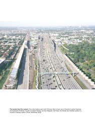
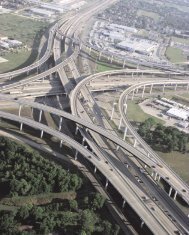
122 Houston FreewaysFew obstacles to freeways: Downtown Houston presented fewobstacles to freeway construction. <strong>The</strong> map above shows the locationsof the freeway sections that presented some difficulty.downtown in 1952, and in 1958 <strong>US</strong> <strong>59</strong> was constructedalongside the property. <strong>The</strong> largest right-of-way clearancefor the downtown freeway system occurred in the late1960s on the south side of downtown, where a very widecorridor was required for the <strong>US</strong> <strong>59</strong>-SH 288 interchange.<strong>The</strong>re were generally no objections to the displacement ofresidences in the neighborhoods around downtown.Another possible roadblock to freeway constructionwas the parkland along Buffalo Bayou just west of downtown,adjacent to the Houston Civic Center. A web ofelevated structures and connection ramps was envisionedfor <strong>IH</strong> 45 through that section of downtown. In a 1979interview, Ralph Ellifrit remarked that “there was considerablediscussion” about building a freeway at that location,but “there was just no way” to build the downtownfreeway system without routing the freeway there. Timewould prove that the freeway would not have a negativeimpact on the park or downtown civic center. 6On the east side of downtown, <strong>US</strong> <strong>59</strong> needed to passover a rail yard which included Union Station, one of thecity’s railway stations for passenger service. In 1953 thecity of Houston began efforts to relocate Union Station,which was controlled by the Houston Belt and TerminalRailroad, to Southern Pacific Railroad’s Grand CentralStation. City planners envisioned connecting the EastexFreeway (<strong>US</strong> <strong>59</strong> north of downtown) into the street immediatelyadjacent to the elevated structure, Chartres, and thethree parallel streets to the west, using a distribution systemsimilar to the “loading platform” where the Gulf Freewaydistributed traffic into downtown. However, UnionStation blocked three of the four streets which would connectto the freeway, making the distribution system impractical.Efforts to relocate the station continued throughthe mid-1950s, with negotiations breaking down by 1958.In 1960 the matter needed to be resolved so constructioncould move forward. On November 2, 1960, officialsfrom the city of Houston, TxDOT, and the railroadreached an agreement after a one-and-a-half hour session.<strong>The</strong> railroad agreed to relocate some tracks to providespace for the columns of the <strong>US</strong> <strong>59</strong> elevated structure, butthe Union Station itself would stay. As a result, the EastexFreeway would lack a full distribution system into downtownin its original construction, since the railroad stationblocked the needed feeder streets. <strong>The</strong> Eastex Freeway’spoor downtown connections would not be improved untilthe major reconstruction of the <strong>US</strong> <strong>59</strong>-<strong>IH</strong> <strong>10</strong> interchangebegan in the late 1990s. Around the same time, constructionof a new baseball stadium began at the location ofthe former Union Station. <strong>The</strong> stadium, opened in March2000, blocked the originally planned street access to thenew interchange from the east side of downtown. 7<strong>The</strong> most controversial section of downtown freewayimpacted commercial property, not residential areas orparks. <strong>IH</strong> 45 on the south side of downtown, now knownas the Pierce Elevated, required acquisition of propertyslated for commercial development by its owners. Twobank structures were planned for the corner of Main andPierce, right in the path of the freeway. In 1956 the cityof Houston refused to issue building permits to the landownersin order to keep the property clear for the freeway.However, freeway construction was estimated tobe 8 to <strong>10</strong> years in the future, and TxDOT did not havefunds available to acquire the right-of-way. <strong>The</strong> landownerscouldn’t improve their property, but there was no moneyavailable to buy it. In 1957 two landowners filed identicallawsuits to overturn the denial of building permits. <strong>The</strong>city was forced to rescind the “building lines” * it had es-(Opposite page) <strong>The</strong> spaghetti bowl: <strong>The</strong> upper photo, taken in May 1961, shows construction in progress to complete<strong>IH</strong> 45 on the west side of downtown. <strong>The</strong> project included the addition of collector-distributor structures and numerousconnection ramps. Engineers dubbed the new interchange the “spaghetti bowl” because of its long, stringlike roadways.<strong>The</strong> term “spaghetti bowl” had fallen into disuse by the 1970s. <strong>The</strong> lower image shows a modern view of <strong>IH</strong> 45 on thewest side of downtown. <strong>The</strong> configuration of the freeway remains unchanged since its completion in 1962. (Photos: upper,TxDOT; lower, September 2002)*“Building lines” were set by the city of Houston and Harris County to define the needed right-of-way for freeways. In general, building permits werenot issued for improvements to property within the building lines.