
Create successful ePaper yourself
Turn your PDF publications into a flip-book with our unique Google optimized e-Paper software.
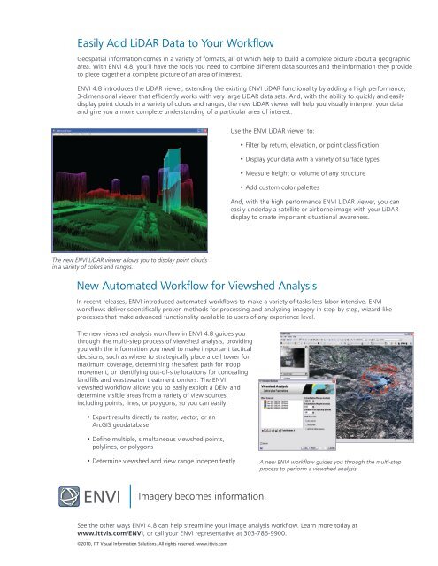
Easily Add LiDAR Data to Your WorkflowGeospatial information comes in a variety of formats, all of which help to build a complete picture about a geographicarea. With <strong>ENVI</strong> <strong>4.8</strong>, you’ll have the tools you need to combine different data sources and the information they provideto piece together a complete picture of an area of interest.<strong>ENVI</strong> <strong>4.8</strong> introduces the LiDAR viewer, extending the existing <strong>ENVI</strong> LiDAR functionality by adding a high performance,3-dimensional viewer that efficiently works with very large LiDAR data sets. And, with the ability to quickly and easilydisplay point clouds in a variety of colors and ranges, the new LiDAR viewer will help you visually interpret your dataand give you a more complete understanding of a particular area of interest.Use the <strong>ENVI</strong> LiDAR viewer to:• Filter by return, elevation, or point classification• Display your data with a variety of surface types• Measure height or volume of any structure• Add custom color palettesAnd, with the high performance <strong>ENVI</strong> LiDAR viewer, you caneasily underlay a satellite or airborne image with your LiDARdisplay to create important situational awareness.The new <strong>ENVI</strong> LiDAR viewer allows you to display point cloudsin a variety of colors and ranges.New Automated Workflow for Viewshed AnalysisIn recent releases, <strong>ENVI</strong> introduced automated workflows to make a variety of tasks less labor intensive. <strong>ENVI</strong>workflows deliver scientifically proven methods for processing and analyzing imagery in step-by-step, wizard-likeprocesses that make advanced functionality available to users of any experience level.The new viewshed analysis workflow in <strong>ENVI</strong> <strong>4.8</strong> guides youthrough the multi-step process of viewshed analysis, providingyou with the information you need to make important tacticaldecisions, such as where to strategically place a cell tower formaximum coverage, determining the safest path for troopmovement, or identifying out-of-site locations for concealinglandfills and wastewater treatment centers. The <strong>ENVI</strong>viewshed workflow allows you to easily exploit a DEM anddetermine visible areas from a variety of view sources,including points, lines, or polygons, so you can easily:• Export results directly to raster, vector, or anArcGIS geodatabase• Define multiple, simultaneous viewshed points,polylines, or polygons• Determine viewshed and view range independentlyA new <strong>ENVI</strong> workflow guides you through the multi-stepprocess to perform a viewshed analysis.<strong>ENVI</strong>Imagery becomes information.See the other ways <strong>ENVI</strong> <strong>4.8</strong> can help streamline your image analysis workflow. Learn more today atwww.ittvis.com/<strong>ENVI</strong>, or call your <strong>ENVI</strong> representative at 303-786-9900.©2010, ITT Visual Information Solutions. All rights reserved. www.ittvis.com