
You also want an ePaper? Increase the reach of your titles
YUMPU automatically turns print PDFs into web optimized ePapers that Google loves.
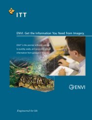
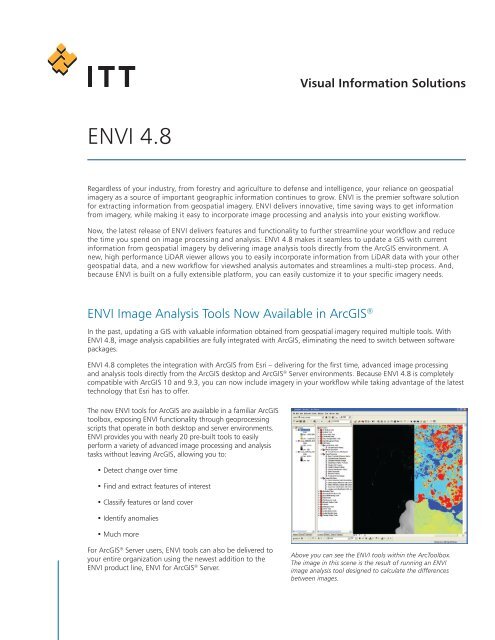
Visual Information Solutions<strong>ENVI</strong> <strong>4.8</strong>Regardless of your industry, from forestry and agriculture to defense and intelligence, your reliance on geospatialimagery as a source of important geographic information continues to grow. <strong>ENVI</strong> is the premier software solutionfor extracting information from geospatial imagery. <strong>ENVI</strong> delivers innovative, time saving ways to get informationfrom imagery, while making it easy to incorporate image processing and analysis into your existing workflow.Now, the latest release of <strong>ENVI</strong> delivers features and functionality to further streamline your workflow and reducethe time you spend on image processing and analysis. <strong>ENVI</strong> <strong>4.8</strong> makes it seamless to update a GIS with currentinformation from geospatial imagery by delivering image analysis tools directly from the ArcGIS environment. Anew, high performance LiDAR viewer allows you to easily incorporate information from LiDAR data with your othergeospatial data, and a new workflow for viewshed analysis automates and streamlines a multi-step process. And,because <strong>ENVI</strong> is built on a fully extensible platform, you can easily customize it to your specific imagery needs.<strong>ENVI</strong> Image Analysis Tools Now Available in ArcGIS ®In the past, updating a GIS with valuable information obtained from geospatial imagery required multiple tools. With<strong>ENVI</strong> <strong>4.8</strong>, image analysis capabilities are fully integrated with ArcGIS, eliminating the need to switch between softwarepackages.<strong>ENVI</strong> <strong>4.8</strong> completes the integration with ArcGIS from Esri – delivering for the first time, advanced image processingand analysis tools directly from the ArcGIS desktop and ArcGIS ® Server environments. Because <strong>ENVI</strong> <strong>4.8</strong> is completelycompatible with ArcGIS 10 and 9.3, you can now include imagery in your workflow while taking advantage of the latesttechnology that Esri has to offer.The new <strong>ENVI</strong> tools for ArcGIS are available in a familiar ArcGIStoolbox, exposing <strong>ENVI</strong> functionality through geoprocessingscripts that operate in both desktop and server environments.<strong>ENVI</strong> provides you with nearly 20 pre-built tools to easilyperform a variety of advanced image processing and analysistasks without leaving ArcGIS, allowing you to:• Detect change over time• Find and extract features of interest• Classify features or land cover• Identify anomalies• Much moreFor ArcGIS ® Server users, <strong>ENVI</strong> tools can also be delivered toyour entire organization using the newest addition to the<strong>ENVI</strong> product line, <strong>ENVI</strong> for ArcGIS ® Server.Above you can see the <strong>ENVI</strong> tools within the ArcToolbox.The image in this scene is the result of running an <strong>ENVI</strong>image analysis tool designed to calculate the differencesbetween images.
Easily Add LiDAR Data to Your WorkflowGeospatial information comes in a variety of formats, all of which help to build a complete picture about a geographicarea. With <strong>ENVI</strong> <strong>4.8</strong>, you’ll have the tools you need to combine different data sources and the information they provideto piece together a complete picture of an area of interest.<strong>ENVI</strong> <strong>4.8</strong> introduces the LiDAR viewer, extending the existing <strong>ENVI</strong> LiDAR functionality by adding a high performance,3-dimensional viewer that efficiently works with very large LiDAR data sets. And, with the ability to quickly and easilydisplay point clouds in a variety of colors and ranges, the new LiDAR viewer will help you visually interpret your dataand give you a more complete understanding of a particular area of interest.Use the <strong>ENVI</strong> LiDAR viewer to:• Filter by return, elevation, or point classification• Display your data with a variety of surface types• Measure height or volume of any structure• Add custom color palettesAnd, with the high performance <strong>ENVI</strong> LiDAR viewer, you caneasily underlay a satellite or airborne image with your LiDARdisplay to create important situational awareness.The new <strong>ENVI</strong> LiDAR viewer allows you to display point cloudsin a variety of colors and ranges.New Automated Workflow for Viewshed AnalysisIn recent releases, <strong>ENVI</strong> introduced automated workflows to make a variety of tasks less labor intensive. <strong>ENVI</strong>workflows deliver scientifically proven methods for processing and analyzing imagery in step-by-step, wizard-likeprocesses that make advanced functionality available to users of any experience level.The new viewshed analysis workflow in <strong>ENVI</strong> <strong>4.8</strong> guides youthrough the multi-step process of viewshed analysis, providingyou with the information you need to make important tacticaldecisions, such as where to strategically place a cell tower formaximum coverage, determining the safest path for troopmovement, or identifying out-of-site locations for concealinglandfills and wastewater treatment centers. The <strong>ENVI</strong>viewshed workflow allows you to easily exploit a DEM anddetermine visible areas from a variety of view sources,including points, lines, or polygons, so you can easily:• Export results directly to raster, vector, or anArcGIS geodatabase• Define multiple, simultaneous viewshed points,polylines, or polygons• Determine viewshed and view range independentlyA new <strong>ENVI</strong> workflow guides you through the multi-stepprocess to perform a viewshed analysis.<strong>ENVI</strong>Imagery becomes information.See the other ways <strong>ENVI</strong> <strong>4.8</strong> can help streamline your image analysis workflow. Learn more today atwww.ittvis.com/<strong>ENVI</strong>, or call your <strong>ENVI</strong> representative at 303-786-9900.©2010, ITT Visual Information Solutions. All rights reserved. www.ittvis.com