ENVI 4.5 Functional Summary - Exelis VIS
ENVI 4.5 Functional Summary - Exelis VIS
ENVI 4.5 Functional Summary - Exelis VIS

You also want an ePaper? Increase the reach of your titles
YUMPU automatically turns print PDFs into web optimized ePapers that Google loves.
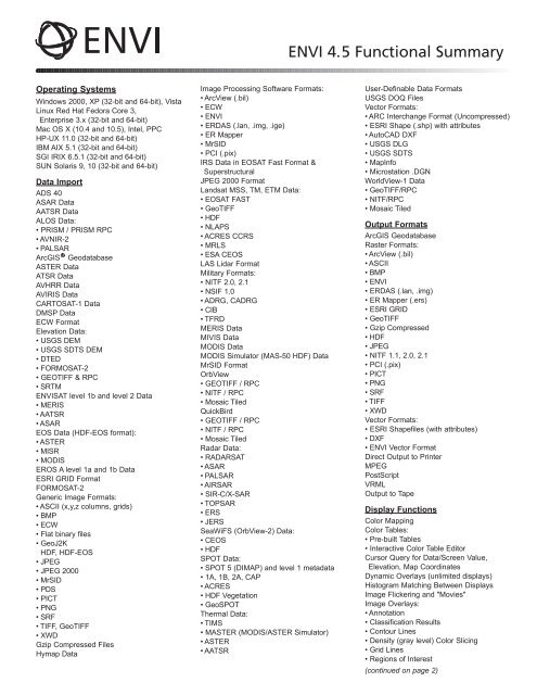
<strong>ENVI</strong> <strong>4.5</strong> <strong>Functional</strong> <strong>Summary</strong>Operating SystemsWindows 2000, XP (32-bit and 64-bit), VistaLinux Red Hat Fedora Core 3,Enterprise 3.x (32-bit and 64-bit)Mac OS X (10.4 and 10.5), Intel, PPCHP-UX 11.0 (32-bit and 64-bit)IBM AIX 5.1 (32-bit and 64-bit)SGI IRIX 6.5.1 (32-bit and 64-bit)SUN Solaris 9, 10 (32-bit and 64-bit)Data ImportADS 40ASAR DataAATSR DataALOS Data:• PRISM / PRISM RPC• AVNIR-2• PALSARArcGIS GeodatabaseASTER DataATSR DataAVHRR DataAVIRIS DataCARTOSAT-1 DataDMSP DataECW FormatElevation Data:• USGS DEM• USGS SDTS DEM• DTED• FORMOSAT-2• GEOTIFF & RPC• SRTM<strong>ENVI</strong>SAT level 1b and level 2 Data• MERIS• AATSR• ASAREOS Data (HDF-EOS format):• ASTER• MISR• MODISEROS A level 1a and 1b DataESRI GRID FormatFORMOSAT-2Generic Image Formats:• ASCII (x,y,z columns, grids)• BMP• ECW• Flat binary files• GeoJ2KHDF, HDF-EOS• JPEG• JPEG 2000• MrSID• PDS• PICT• PNG• SRF• TIFF, GeoTIFF• XWDGzip Compressed FilesHymap DataImage Processing Software Formats:• ArcView (.bil)• ECW• <strong>ENVI</strong>• ERDAS (.lan, .img, .ige)• ER Mapper• MrSID• PCI (.pix)IRS Data in EOSAT Fast Format &SuperstructuralJPEG 2000 FormatLandsat MSS, TM, ETM Data:• EOSAT FAST• GeoTIFF• HDF• NLAPS• ACRES CCRS• MRLS• ESA CEOSLAS Lidar FormatMilitary Formats:• NITF 2.0, 2.1• NSIF 1.0• ADRG, CADRG• CIB• TFRDMERIS DataMI<strong>VIS</strong> DataMODIS DataMODIS Simulator (MAS-50 HDF) DataMrSID FormatOrbView• GEOTIFF / RPC• NITF / RPC• Mosaic TiledQuickBird• GEOTIFF / RPC• NITF / RPC• Mosaic TiledRadar Data:• RADARSAT• ASAR• PALSAR• AIRSAR• SIR-C/X-SAR• TOPSAR• ERS• JERSSeaWiFS (OrbView-2) Data:• CEOS• HDFSPOT Data:• SPOT 5 (DIMAP) and level 1 metadata• 1A, 1B, 2A, CAP• ACRES• HDF Vegetation• GeoSPOTThermal Data:• TIMS• MASTER (MODIS/ASTER Simulator)• ASTER• AATSRUser-Definable Data FormatsUSGS DOQ FilesVector Formats:• ARC Interchange Format (Uncompressed)• ESRI Shape (.shp) with attributes• AutoCAD DXF• USGS DLG• USGS SDTS• MapInfo• Microstation .DGNWorldView-1 Data• GeoTIFF/RPC• NITF/RPC• Mosaic TiledOutput FormatsArcGIS GeodatabaseRaster Formats:• ArcView (.bil)• ASCII• BMP• <strong>ENVI</strong>• ERDAS (.lan, .img)• ER Mapper (.ers)• ESRI GRID• GeoTIFF• Gzip Compressed• HDF• JPEG• NITF 1.1, 2.0, 2.1• PCI (.pix)• PICT• PNG• SRF• TIFF• XWDVector Formats:• ESRI Shapefiles (with attributes)• DXF• <strong>ENVI</strong> Vector FormatDirect Output to PrinterMPEGPostScriptVRMLOutput to TapeDisplay FunctionsColor MappingColor Tables:• Pre-built Tables• Interactive Color Table EditorCursor Query for Data/Screen Value,Elevation, Map CoordinatesDynamic Overlays (unlimited displays)Histogram Matching Between DisplaysImage Flickering and "Movies"Image Overlays:• Annotation• Classification Results• Contour Lines• Density (gray level) Color Slicing• Grid Lines• Regions of Interest(continued on page 2)
• Vector LayersInteractive 2-D Scatter PlottingInteractive Histograms & Stretching:• Arbitrary Stretching• Auto Apply Stretches• Gaussian Stretching• Histogram Equalization Stretching• Histogram Matching Between Displays• Linear, Piecewise Linear Stretching• Square Root Stretching• Import/Export ASCII Look Up Tables• User-Defined Look Up TablesInteractive Pixel EditorLine-of-Sight (Viewshed) AnalysisLink Unlimited DisplaysMeasurement ToolOutput Displays to File or PrinterOutput Displays of Zoom WindowQuick Filters:• Sharpen• Smooth• MedianQuick Color-Infrared, True-Color DisplaysSave and/or Restore Display GroupSelect Display Bands from Spectral PlotsSet Default Display BandsSpatial and Spectral Pixel EditingSpatial and Spectral ProfilesSub-Pixel Cursor LocationUnlimited Number of DisplaysVirtual MosaicVector Overlays & GIS CapabilitiesRegions of InterestBuffer Zones Around ROIsClassification Images from ROIsExport ROIs to VectorsInput ROIs from ASCIIInteractive, Easy-to-use ROI Definition:• Draw Polygons, Polylines, Pixels• Draw ROIs with Interior Spaces (Donuts)• ROIs from Intersection of Other ROIs• Multiple Objects Within One ROI• ROI Definition via Scatter Plots• Threshold Images to ROI• Merge ROIs• Import ROIs from VectorsOutput ROIs to ASCIIROI Save & RestoreReconcile ROIs between Images viaMap CoordinatesROI Growing Based on StatisticsROI StatisticsData PreparationCreate New Standard or Virtual Image Filefrom Existing BandsGenerate Test ImageMask Generation From:• Annotation• Image Data Values• ROIs• Intersection of ROIs• Vectors• NaNMosaic Functions:• Color Mosaic Preview• Cutline & Edge Feathering• Interactively Mosaic Multiple Bands, Files• Mosaic by Pixel (Line, Sample) or MapCoordinates• Automatic Color Balancing• Standard Image or Virtual Mosaic OutputDefine Spatial Subset by:• Drawing on Display• File, Map Coordinates• Region of Interest• Other Image Extent• Meta Scroll ExtentRotate/Flip DataSpatial and Spectral SubsetsStorage Order (Interleave) Conversions:• BSQ, BIL, BIP• New File or Replace OriginalStretch DataSubsample ImagesPre-processing & CalibrationApply Gain & OffsetBad Band IdentificationBad Line ReplacementBad Pixel ReplacementCross-Track Illumination CorrectionDark SubtractionDestripe DataEmpirical Line CalibrationERS and Radarsat Data CalibrationFlat Field CalibrationIgnore Pixel ValueInternal Average Relative ReflectanceCalibrationLog ResidualsMODIS Bowtie CorrectionRadiometric Calibrations:• AVHRR• Landsat MSS, TM, ETM• TIMS• QuickBirdSea Surface Temperature From AVHRRThermal Atmospheric CorrectionRegistration & RectificationAssociate DEM With ImageAutomatic Georeferencing of ASTER,AVHRR, AATSR, ASAR, MERIS, MODIS,Radarsat, SeaWiFS, SPOTSubpixel Ground Control Point LocationsGeorectify SPOT Using Information FromLeader FileGround Control Points PredictionImage-to-Map RegistrationImage-to-Image RegistrationInteractive Ground Control Point CollectionImport Ground Control Points from FileOrthorectification:• Aerial Photographs (Digital and Frame)• ASTER• CARTOSAT-1• Generic RPC• Generic Pushbroom Sensors• IKONOS• OrbView - 3• QuickBird• SPOT 1-5Radial ResamplingRational Polynomial Coefficients(RPCs) SupportReplacement Sensor Model (RSM)Real-time GPS LinkRotated ProjectionsSave Transformation Matrix to ASCIIWarp Resampling Methods:• Bilinear• Cubic Convolution• Nearest NeighborWarping Methods:• Delaunay Triangulation• Polynomial• Rotation, Scaling, Translation (RST)Map Projection SupportConvert Coordinates Among ProjectionsContours From Any Registered ImageConvert Map ProjectionDatum Support (>100)Dozens of Prebuilt Map Projections(Examples Include):• Universal Transverse Mercator (UTM)• State Plane• Gauss-Kruger• Map Grid of Australia• Mississippi Standard Transverse MercatorEllipsoid Support (>35)Pseudo-Projections from RPCs and RSMUser-Defined Map ProjectionsUser-Defined Projection UnitsUSGS GCTP Projections, Including:• Albers Conical Equal Area• Azimuthal Equal Area• Lambert Conformal Conic• Space Oblique Mercator (A & B)• Stereographic• Transverse MercatorVector GIS FunctionsAdd Nodes to VectorsAnnotate Vector WindowsAttributes:• Create New Vector Attributes• Edit Query Vector Attributes• Import from ArcView Shapefiles, ASCII• Query to Create New Vector LayerBurn-in Vectors on Raster ImageConvert Vector Layer ProjectionCreate Contour Vectors from Raster DataCreate New Vector LayersCreate Vector Boundaries:• Countries, States, Coasts, Rivers• For Whole World• For Lat/Long BoundariesDirect Printing of GIS LayersDisplay Vectors with Different Projections inthe Same WindowDrag/Drop to Arrange Layer OrderEdit Layer CharacteristicsExport Vector Data to Common GIS FormatsExport Vector AttributesGPS InputHeads-up (On-screen) DigitizingIntelligent DigitizerImport Common GIS Formats:• ESRI Shapefiles• Arc Interchange• AutoCAD DXF• MapInfo• Microstation DGN• USGS DLG(continued on page 3)
• USGS SDTS• <strong>ENVI</strong> Native Vector FormatInteractive Vector Layer QueryingJoin VectorsMultiple Vector SelectionOn-the-fly Vector Projection ConversionRaster to Vector ConversionsSplit VectorsVector Cursor QueryVector Display ZoomingVector EditingVector to Raster ConversionSpectral Analysis ToolsAnomaly DetectionAutomated Corner Clustering in N-D Scatter PlotBandMax Band OptimizationContinuum Removal of Images, SpectraDecision Tree ClassifierExtraction of Endmember SpectraIntegrated Spectral Viewing & AnalysisLinear Spectral UnmixingLeast Squares (LS) FitMatched FilteringMixture Tuned Matched FilteringN-Dimensional Visualizer (Scatter Plot)Pixel EditingPixel Purity Index (PPI)Registration Suppression AlgorithmSAM Target Finder With BandMaxSMACC Endmember Extraction & Sub-pixelAnalysisSPEAR Tools:• Change Detection - PCA• Change Detection - Subtractive• Pan-Sharpening• Lines of Communication - Water• Lines of Communication - Roads• Watercraft Finder• Relative Water Depth• Vegetation Delineation and Stress Detection• Spectral Analogues• TERCAT (Terrain Categorizations)Spectral Resampling:• Predefined Sensor Band Filters• User Defined Filters• Spectral Libraries and ImagesSpectral Analyst for Material IdentificationSpectral Angle Mapper (SAM)Spectral Feature Fitting (SFF)Spectral Hourglass WizardSpectral Information DivergenceSpectral Libraries Included:• Spectral Information Divergence• Minerals, Vegetation, Rocks, Water, Soils,Snow, Manmade• VNIR, SWIR, MWIR, LWIRSpectral Library Builder/ImporterSpectral Library ViewerSpectral MathSpectral Plots:• Boxcar Average of Pixel Spectra• Continuum Removal• Cursor Query of X,Y Plot Values• Drag and Drop Spectra Among Plot• From 3D SurfaceView• From Image Pixels (Z Profile)• From Spectral Libraries• From ROI Averages• Link Spectral Plots from Multiple Images• Plot Stacked Spectra• User-Defined Plot Functions• Wavenumber or WavelengthSpectral SlicesVegetation Guided Workflows• Fire Fuel Load• Agricultural Stress• Forest HealthVegetation Indices• Greenness• Light-use Efficiency• Canopy Nitrogen• Senescent Carbon• Canopy Water• Leaf PigmentVegetation Suppression AlgorithmTransformsBand RatiosColor Transforms:• RGB to HSV, HSL, or Munsell HSV• HSV, HSL, or Munsell HSV to RGBDecorrelation StretchIndependent Components AnalysisImage Sharpening:• Color Normalized Spectral• Gram-Schmidt Spectral• HSV and Brovey• PC Spectral• Preserving Spectral IntegrityMinimum Noise Fraction (MNF)Normalized Difference Vegetation Index (NDVI)Pan Sharpening (see Image Sharpening)Principal Components RotationSaturation StretchSynthetic Color ImageTasseled CapFiltersAdaptive Filters:• Frost, Enhanced Frost Gamma, Kuan, Lee,Enhanced Lee, Local Sigma, Bit ErrorConvolution Filters:• High & Low Pass, Laplacian, Directional,Gaussian, Median, Sobel, RobertsFiltering PreviewInteractive Fourier Filtering:• Forward Transform• Interactive Frequency Domain Masking• Inverse TransformMorphology Filters:• Dilate, Erode, Opening, ClosingTexture Filters:• Data Range, Mean, Variance, Entropy,Skewness, Homogeneity, Contrast,Dissimilarity, Second Moment, CorrelationUser-Defined Filter KernelsMathematics & StatisticsAutocorrelationBand HistogramsBand Math and Spectral Math:• Boolean Operators• Trigonometric Functions• Data Type Conversion Functions• Relational Operators• Many Other Mathematical ExpressionsCorrelogramsDisplay Statistics:• Minimum, Maximum, Mean, StandardDeviationImage Statistics:• Band Minimum, Maximum, Mean, StandardDeviation, Eigenvalues, Eigenvectors,Covariance, Correlation MatricesOutput Matrix Stats to Image Files:• Covariance Matrix• Correlation Matrix• EigenvectorsSemivariogramsImage ClassificationAccuracy AssessmentAIRSAR Scattering Mechanism ClassifierAutomatic Legends for Classified ImagesChange Detection, Thematic and GrayscaleImagesClassification PreviewClass StatisticsClassification Image from ROIsDecision TreesDensity SlicingInteractive User-Defined Rule ClassifierReceiver Operating Characteristic (ROC)Curves:• Find Optimal Classification Thresholds• Decrease False ClassificationsSeparate Classification Thresholds for EachClassSupervised Classifications:• Binary Encoding• Parallelepiped• Mahalanobis Distance• Minimum Distance• Maximum Likelihood• Neural Network• Spectral Angle Mapper (SAM)• Support Vector Machine (SVM)• TERCAT (Terrain Categorization)• Change Detection - PCA• Change Detection - SubtractionTraining Data From:• Regions of Interest• Pixel Spectra• Library SpectraUnsupervised Classifications:• K-means• IsodataVegetation Guided Workflows• Fire Fuel Load• Agricultural Stress• Forest HealthPost Classification ToolsAccuracy Assessment:• Kappa Coefficient• Confusion MatrixClassification to VectorClass StatisticsInteractive Class Overlay ToolReassign Class Colors, NamesSpatial Functions:• Buffer Zones Around Classes• Clump, Sieve, Combine• Majority & Minority Analysis• Segmentation Image(continued on page 4)
Stratified Random Point GenerationTopographic AnalysisAssociate DEM with ImageCalculate Slope and Aspect ImagesCalculate Shaded Relief ImageCreate DEM From Vector Elevation ContoursHillshade (Shaded Relief Combined withRGB Image)Line-of-Sight (Viewshed) AnalysisRasterize Point DataTopographic Measures:• Convexity• Plan Convexity• Longitudinal Convexity• Cross Sectional convexity• Minimum Curvature• Maximum CurvatureThree-Dimensional VisualizationTopographic Feature Extraction(Classification):• Ridge, Channel, Plane, Peak, Pit3-D SurfaceViewAnimated 360” VisualizationAssociate DEM With ImageChange View Interactively Using MouseCreate Fly-Through Sequence:• Interpolate Between User Selected Views• Follow Annotation LineCustom Background ColorDrape Image Over 3-D SurfaceOutput Fly-Through Sequence:• MPEG, VRML 2.0Overlay Vectors, Regions Of InterestSet Vertical ExaggerationSmooth Image, DEMAnnotation and Map CompositionAutomatic Contour LabelingAutomatic Legends for Classified Images,Scale Bars, and Color Ramps Text,Polygons, Polylines, Points, SymbolsBurn-in or Overlay AnnotationsCartographic SymbolsContour Lines from DEM, Other ImagesCreate Reusable Map TemplatesGrid Lines: Pixel, Lat/Long &/or Map GridsInset Images (e.g., Logos) or Vector PlotsInteractive Map Composition Using ImageDisplaysInteractively Reposition Annotation and MapElementsInteractive Plot ScalingRotated Map ProjectionsSave & Restore All ParametersTrueTypefi Fonts (Plus Add Your Own)User Definable Arrows, Declination Diagrams(True, Grid and Magnetic North)Vector OverlaysRadar <strong>Functional</strong>ityAdaptive (Speckle Reduction) Filters:• Frost• Enhanced Frost• Gamma• Kuan• Lee• Enhanced Lee• Local Sigma• Bit ErrorAntenna Pattern CorrectionAIRSAR Scattering Mechanism ClassifierCEOS Tape ReadingConvert integrated TOPSAR to:• C-band VV data• Correlation image• Digital Elevation Model (DEM)• Incident Angle image• L- and P-band polarimetric AIRSAR DataDisplay and Analyze Radar Data UsingStandard <strong>ENVI</strong> toolsEdge Enhancement FiltersImport ASAR, ERS, JERS, RADARSAT, AIR-SAR, TOPSAR, SIR-C/X-SARIncident Angle ImagesMulti-Look SIR-C DataPedestal Height ImagesPhase Difference ImagesPolarization Signatures from ROIs & SinglePixelsRADARSAT Level 2 EndorsementSigma nought and Beta nought from ERS,RadarsatSlant-to-Ground Range ConversionSynthetic Color ImageSynthesize Images from Compressed,Complex Scattering Matrix DataTexture MeasuresView CEOS HeadersGeneral Interface & Operation8- and 24-Bit Color, Multiple DisplaysAccess to IDL Functions*Add Custom Routines to MenuBatch Recording, Queuing, and PlaybackBuild Scripts for Common Functions*Command Line Use of <strong>ENVI</strong> Routines *Context-Sensitive Mouse DescriptionsCursor Coordinates (Pixel & Map) , DataValues, and ElevationsDirect Link to GPS Devices (Real-time Input)Edit <strong>ENVI</strong> Header InformationEfficient Memory ManagementExtensive Preferences SettingsGeo-Browser Image Selection from GraphicalIndex MapLogical Menu-Based GUI (Graphical UserInterface)Multi-Processor Aware AlgorithmsPlatform-Independent OperationRecursive Directory Scanning for FilesSupport for Files Greater than 2GBUser-Configurable Menus & ButtonsModules<strong>ENVI</strong> Certified NITF Module• <strong>ENVI</strong> Certified NITF Module with TFRD<strong>ENVI</strong> DEM Extraction Module for StereoImages<strong>ENVI</strong> FLAASH Module for AtmosphericCorrection<strong>ENVI</strong> Feature Extraction ModuleSARscape Family of Modules for <strong>ENVI</strong>DocumentationContext-Sensitive HelpModule DocumentationOn-line, Hyperlinked DocumentationPrinted DocumentationProgrammer’s Guide (with Examples)Training ManualsTutorials & Sample DataUser’s Guide* Only available in <strong>ENVI</strong>+IDL.<strong>ENVI</strong>, FreeLook and IDL are registered trademarks of ITTIndustries Inc. All other trademarks or brand names arethe property of their respective owners. All RightsReserved.This document reflects the functionality in the <strong>ENVI</strong>interface. The <strong>ENVI</strong> Zoom interface provides a subset ofthis functionality with additional display features.For more infomation about <strong>ENVI</strong> Zoom please visitwww.ittvis.com/envizoom.ITT Visual Information Solutions4990 Pearl East Circle • Boulder CO, 80301303.786.9900 • www.ittvis.com