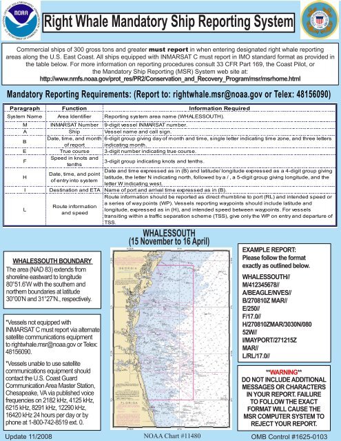
Right Whale Mandatory Ship Reporting System - NOAA
Right Whale Mandatory Ship Reporting System - NOAA
Right Whale Mandatory Ship Reporting System - NOAA

Create successful ePaper yourself
Turn your PDF publications into a flip-book with our unique Google optimized e-Paper software.
<strong>Right</strong> <strong>Whale</strong> <strong>Mandatory</strong> <strong>Ship</strong> <strong>Reporting</strong> <strong>System</strong>Commercial ships of 300 gross tons and greater must report in when entering designated right whale reportingareas along the U.S. East Coast. All ships equipped with INMARSAT C must report in IMO standard format as provided inthe table below. For more information on reporting procedures consult 33 CFR Part 169, the Coast Pilot, orthe <strong>Mandatory</strong> <strong>Ship</strong> <strong>Reporting</strong> (MSR) <strong>System</strong> web site at:http://www.nmfs.noaa.gov/prot_res/PR2/Conservation_and_Recovery_Program/msr/msrhome.html<strong>Mandatory</strong> <strong>Reporting</strong> Requirements: (Report to: rightwhale.msr@noaa.gov or Telex: 48156090)Paragraph Function Information Required<strong>System</strong> Name Area Identifier <strong>Reporting</strong> system area name (WHALESSOUTH).M INMARSAT Number 9-digit vessel INMARSAT number.A <strong>Ship</strong> Vessel name and call sign.BDate, time, and month 6-digit group giving day of month and time, single letter indicating time zone, and three lettersof report indicating month.E True course 3-digit number indicating true course.FSpeed in knots andtenths3-digit group indicating knots and tenths.HWHALESSOUTH BOUNDARYThe area (NAD 83) extends fromshoreline eastward to longitude80°51.6’W with the southern andnorthern boundaries at latitude30°00’N and 31°27’N., respectively.*Vessels not equipped withINMARSAT C must report via alternatesatellite communications equipmentto rightwhale.msr@noaa.gov or Telex:48156090.*Vessels unable to use satellitecommunications equipment shouldcontact the U.S. Coast GuardCommunication Area Master Station,Chesapeake, VA via published voicefrequencies on 2182 kHz, 4125 kHz,6215 kHz, 8291 kHz, 12290 kHz,16420 kHz 24 hours per day or byphone at 1-800-742-8519 ext. 0.Update 11/2008Date, time, and pointof entry into systemDate and time expressed as in (B) and latitude/ longitude expressed as a 4-digit group givinglatitude, the letter N indicating north, followed by a / , a 5-digit group giving longitude, and theletter W indicating west.I Destination and ETA Name of port and arrival time expressed as in (B).LRoute informationand speedRoute information should be reported as direct rhumbline to port (RL) and intended speed ora series of way points (WP). Vessels reporting waypoints should include latitude andlongitude, expressed as in (H), and intended speed between waypoints. For vesselstransiting within a traffic separation scheme (TSS), give only the WP on entry and departure ofTSS.WHALESSOUTH(15 November to 16 April)<strong>NOAA</strong> Chart #11480EXAMPLE REPORT:Please follow the formatexactly as outlined below.WHALESSOUTH//M/412345678//A/BEAGLE/NVES//B/270810Z MAR//E/250//F/17.0//H/270810ZMAR/3030N/08052W//I/MAYPORT/271215ZMAR//L/RL/17.0//**WARNING**DO NOT INCLUDE ADDITIONALMESSAGES OR CHARACTERSIN YOUR REPORT. FAILURETO FOLLOW THE EXACTFORMAT WILL CAUSE THEMSR COMPUTER SYSTEM TOREJECT YOUR REPORT.OMB Control #1625-0103
<strong>Right</strong> <strong>Whale</strong> <strong>Mandatory</strong> <strong>Ship</strong> <strong>Reporting</strong> <strong>System</strong>Commercial ships of 300 gross tons and greater must report in when entering designated right whale reportingareas along the U.S. East Coast. All ships equipped with INMARSAT C must report in IMO standard format as provided inthe table below. For more information on reporting procedures consult 33 CFR Part 169, the Coast Pilot, orthe <strong>Mandatory</strong> <strong>Ship</strong> <strong>Reporting</strong> (MSR) <strong>System</strong> web site at:http://www.nmfs.noaa.gov/prot_res/PR2/Conservation_and_Recovery_Program/msr/msrhome.html<strong>Mandatory</strong> <strong>Reporting</strong> Requirements: (Report to: rightwhale.msr@noaa.gov or Telex: 48156090)Paragraph Function Information Required<strong>System</strong> Name Area Identifier <strong>Reporting</strong> system area name (WHALESNORTH).M INMARSAT Number 9-digit vessel INMARSAT number.A <strong>Ship</strong> Vessel name and call sign.BDate, time, and month 6-digit group giving day of month and time, single letter indicating time zone, and three lettersof report indicating month.E True course 3-digit number indicating true course.FSpeed in knots andtenths3-digit group indicating knots and tenths.HDate, time, and pointof entry into systemWHALESNORTH BOUNDARYThe area coordinates (NAD 83) areas follows: from a point on Cape Ann,Massachusetts at 42°39’N, 70°37’W;then northeast to 42°45’N, 70°13’W;then southeast to 42°10’N, 68°31’W;then south to 41°00’N, 68°31’W;then west to 41°00’N, 69°17’W;then northwest to 42°05’N, 70°02’W,then west to 42°04’N, 70°10’W;and then along the Massachusettsshoreline of Cape Cod Bay andMassachusetts Bay back to the pointon Cape Ann at 42°39’N, 70°37’W.Date and time expressed as in (B) and latitude/ longitude expressed as a 4-digit group givinglatitude, the letter N indicating north, followed by a / , a 5-digit group giving longitude, and theletter W indicating west.I Destination and ETA Name of port and arrival time expressed as in (B).LRoute informationand speedRoute information should be reported as direct rhumbline to port (RL) and intended speed ora series of way points (WP). Vessels reporting waypoints should include latitude andlongitude, expressed as in (H), and intended speed between waypoints. For vesselstransiting within a traffic separation scheme (TSS), give only the WP on entry and departure ofTSS.WHALESNORTH(year round)EXAMPLE REPORT:Please follow the formatexactly as outlined below.WHALESNORTH//M/487654321//A/CALYPSO/NRUS//B/031401Z APR//E/345//F/15.5//H/031410ZAPR/4104N/06918W//I/BOSTON/032345Z APR//L/WP/4104N/06918W/15.5//L/WP/4210N/06952W/15.5//L/WP/4230N/07006W/15.5//<strong>NOAA</strong> Chart #13009*Vessels not equipped with INMARSAT C must report via alternate satellitecommunications equipment to rightwhale.msr@noaa.gov or Telex: 48156090.*Vessels unable to use satellite communications equipment should contact the U.S.Coast Guard Communication Area Master Station, Chesapeake, VA via publishedvoice frequencies on 2182 kHz, 4125 kHz, 6215 kHz, 8291 kHz, 12290 kHz, 16420kHz 24 hours per day or by phone at 1-800-742-8519 ext. 0.Update 11/2008**WARNING**DO NOT INCLUDE ADDITIONALMESSAGES OR CHARACTERSIN YOUR REPORT. FAILURETO FOLLOW THE EXACTFORMAT WILL CAUSE THEMSR COMPUTER SYSTEM TOREJECT YOUR REPORT.OMB Control #1625-0103


![Right Whale Fact Sheet [PDF] - Southeast Regional Office - NOAA](https://img.yumpu.com/28432664/1/190x245/right-whale-fact-sheet-pdf-southeast-regional-office-noaa.jpg?quality=85)