
Create successful ePaper yourself
Turn your PDF publications into a flip-book with our unique Google optimized e-Paper software.
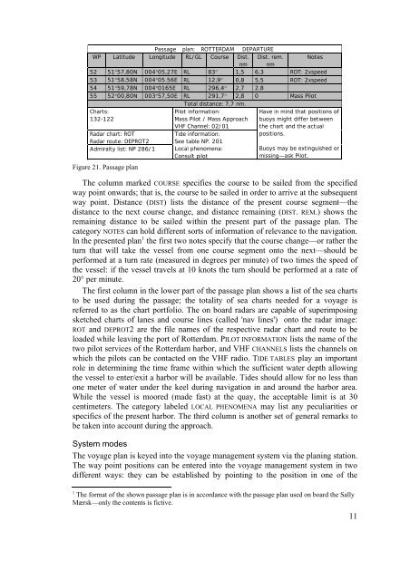
Passage plan: ROTTERDAM DEPARTUREWP Latitude Longitude RL/GL Course Dist. Dist. rem. Notesnm nm52 51°57,80N 004°05,27E RL 83° 1,5 6,3 ROT: 2xspeed53 51°58,58N 004°05.56E RL 12,9° 0,8 5,5 ROT: 2xspeed54 51°59,78N 004°0165E RL 296,4° 2,7 2,855 52°00,80N 003°57,50E RL 291,7° 2,8 0 Mass PilotTotal distance: 7,7 nm.Charts:132-122Radar chart: ROTRadar route: DEPROT2Admiralty list: NP 286/1Figure 21. Passage planPilot information:Mass Pilot / Mass ApproachVHF Channel: 02/01Tide information:See table NP. 201Local phenomena:Consult pilotHave in mind that positions ofbuoys might differ between<strong>the</strong> chart and <strong>the</strong> actualpositions.Buoys may be extinguished ormissing—ask Pilot.The column marked COURSE specifies <strong>the</strong> course to be sailed from <strong>the</strong> specifiedway point onwards; that is, <strong>the</strong> course to be sailed in order to arrive at <strong>the</strong> subsequentway point. Distance (DIST) lists <strong>the</strong> distance of <strong>the</strong> present course segment—<strong>the</strong>distance to <strong>the</strong> next course change, and distance remaining (DIST. REM.) shows <strong>the</strong>remaining distance to be sailed within <strong>the</strong> present part of <strong>the</strong> passage plan. Thecategory NOTES can hold different sorts of information of relevance to <strong>the</strong> navigation.In <strong>the</strong> presented plan 1 <strong>the</strong> first two notes specify that <strong>the</strong> course change—or ra<strong>the</strong>r <strong>the</strong>turn that will take <strong>the</strong> vessel from one course segment onto <strong>the</strong> next—should beperformed at a turn rate (measured in degrees per minute) of two times <strong>the</strong> speed of<strong>the</strong> vessel: if <strong>the</strong> vessel travels at 10 knots <strong>the</strong> turn should be performed at a rate of20° per minute.The first column in <strong>the</strong> lower part of <strong>the</strong> passage plan shows a list of <strong>the</strong> sea chartsto be used during <strong>the</strong> passage; <strong>the</strong> totality of sea charts needed for a voyage isreferred to as <strong>the</strong> chart portfolio. The on board radars are capable of superimposingsketched charts of lanes and course lines (called 'nav lines') onto <strong>the</strong> radar image:ROT and DEPROT2 are <strong>the</strong> file names of <strong>the</strong> respective radar chart and route to beloaded while leaving <strong>the</strong> port of Rotterdam. PILOT INFORMATION lists <strong>the</strong> name of <strong>the</strong>two pilot services of <strong>the</strong> Rotterdam harbor, and VHF CHANNELS lists <strong>the</strong> channels onwhich <strong>the</strong> pilots can be contacted on <strong>the</strong> VHF radio. TIDE TABLES play an importantrole in determining <strong>the</strong> time frame within which <strong>the</strong> sufficient water depth allowing<strong>the</strong> vessel to enter/exit a harbor will be available. Tides should allow for no less thanone meter of water under <strong>the</strong> keel during navigation in and around <strong>the</strong> harbor area.While <strong>the</strong> vessel is moored (made fast) at <strong>the</strong> quay, <strong>the</strong> acceptable limit is at 30centimeters. The category labeled LOCAL PHENOMENA may list any peculiarities orspecifics of <strong>the</strong> present harbor. The third column is ano<strong>the</strong>r set of general remarks tobe taken into account during <strong>the</strong> approach.System modesThe voyage plan is keyed into <strong>the</strong> voyage management system via <strong>the</strong> planing station.The way point positions can be entered into <strong>the</strong> voyage management system in twodifferent ways: <strong>the</strong>y can be established by pointing to <strong>the</strong> position in one of <strong>the</strong>1The format of <strong>the</strong> shown passage plan is in accordance with <strong>the</strong> passage plan used on board <strong>the</strong> <strong>Sally</strong>Mærsk—only <strong>the</strong> contents is fictive.11