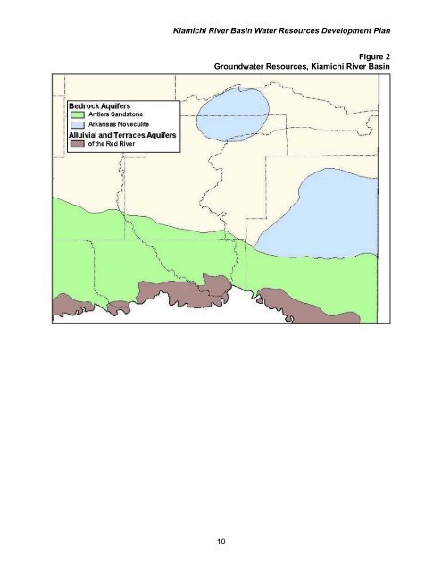
Kiamichi River Basin Water Resources Development PlanTable 1Historical Streamflow Data, Kiamichi River BasinDrainageAnnual Flow for Period of RecordGageArea Minimum Maximum Average(square miles) (ac-ft/yr) (ac-ft/yr) (cfs) (ac-ft/yr) (mgd)Big Cedar 40 24,544 110,048 86 62,264 56Clayton 708 396,028 1,424,108 1,127 815,948 728Antlers 1,138 569,064 2,305,216 1,821 1,318,404 1,176Hugo 1,709 484,356 3,050,000 2,202 1,594,248 1,422All data from U.S. Geological Survey stream gages, except Hugo, which is estimated inflow fromthe Corps of Engineers reservoir gage.Stream Water QualityThe quality of <strong>water</strong> in the Kiamichi River Basin is considered excellent with littlemineralization. The <strong>water</strong> is suitable for irrigation and, with treatment, is an excellentsource for municipal and industrial purposes. The <strong>water</strong> is moderately turbid andclassified as soft.Ground<strong>water</strong> Resources & QualityIn addition to alluvium and terrace deposits of the Red River, two major ground<strong>water</strong> <strong>basin</strong>sunderlie the Kiamichi River Basin (Figure 2). The Antlers Sandstone (Cretaceous in age, laiddown 53 to 133 million years ago) is a fine-grained sand interbedded with clay, unconsolidatedand friable. It crops out in a 10-mile-wide belt in parts of Atoka, Bryan, Choctaw, Johnston,McCurtain and Pushmataha Counties. The entire Choctaw County portion of the Kiamichi RiverBasin, along with small portions of Atoka and Pushmataha Counties, is underlain by the AntlersSandstone formation. It is estimated that at least 320 square miles of the aquifer’s 4,400-square-mile area (2,816,000 acres) lies under the <strong>basin</strong>.Through its entire extent, the Antlers Sandstone ranges in thickness from 180 feet in thewest to more than 880 feet in the southeast. Well yields range from 5 to 50 gallons per minute(gpm) for <strong>water</strong> table wells and from 50 to 650 gpm in artesian wells. An average yield for wellscompleted in the ground<strong>water</strong> <strong>basin</strong> is 100 to 150 gpm.Ground<strong>water</strong> quality is good in the outcrop areas and suitable for industrial, municipal andirrigation use. Downdip from those areas, the quality deteriorates. Dissolved solids range from130 to 1,240 milligrams per liter (mg/L); hardness from 8 to 300 mg/L; sodium from 1 to 350mg/L; and bicarbonate from 10 to 580 mg/L.The other major ground<strong>water</strong> <strong>basin</strong>, the Arkansas Novaculite and Bigfork Chert, exists in thePotato Hills area of Pushmataha and Latimer Counties and virtually the entire extent of the twoformations (estimated at 33 square miles, or 21,120 acres) underlie the Kiamichi River Basin.With a combined thickness of 850 to 1,200 feet, the formations consist of highly fracturednovaculite and chert with some interbedded shale and limestone. The formations are probablycapable of storing and yielding moderate to large amounts of <strong>water</strong>. However, because of thearea’s remoteness, few wells have been drilled into the aquifer and its potential can only beinferred. Due to extensive folding and faulting of the formations, selection of a well site requirescareful study.9
Kiamichi River Basin Water Resources Development Plan,~~~~---_',f"-v'Bedrock AquifersoAntlers SandstoneArkansas NoveculiteAlluivial and Terraces Aquiferso ofthe Red RiverFigure 2Ground<strong>water</strong> Resources, Kiamichi River Basin,,~::--,--~~_.j..".r-.,..\.._.,'~..-'''''-.",,_________L_, ,_ .. _ .. ~._._ .. _ ..-.-.. _ .. _._._ .. _ .. _._ I~.~.' I \_._j,,___L,_;-'\ r-"\I I)i \ I-"-"-"--""'-i-"-"-"-"- •. _ .. -,~


![A Commodity & a Resource [pdf] - Water Resources Board - State of ...](https://img.yumpu.com/42536671/1/190x143/a-commodity-a-resource-pdf-water-resources-board-state-of-.jpg?quality=85)