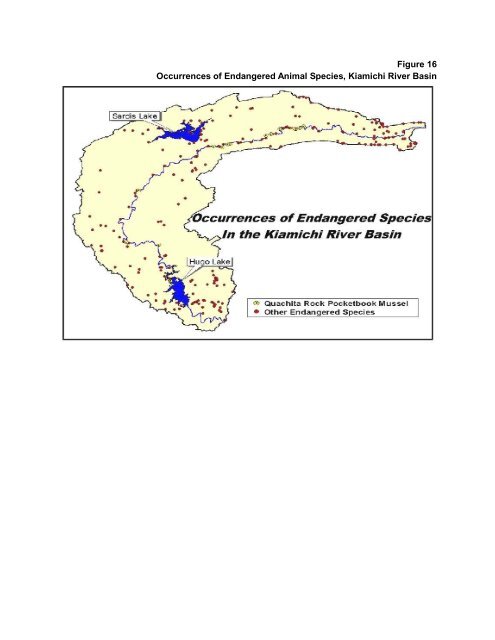
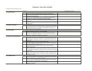
Figure 16Occurrences of Endangered Animal Species, Kiamichi River Basin•••• •.' •• • ••Occurrences ofEndangered Specie~.• "•.......""',In the Kiamichi River Basin• • •o Lake• :•• • (0) Quachita Rock Pocketbook Mussel• other Endangered Species
Implementing an Appropriate Hugo Lake Level Management Plan“Implement an appropriate Hugo Lake level management <strong>plan</strong> that includes flexibility foradjustments due to future sedimentation.”“Protect Hugo Lake’s wildlife management and <strong>water</strong>fowl areas, including appropriatemitigation measures.”Under consideration by the Kiamichi River Basin Working Group were several lake levelmanagement <strong>plan</strong>s proposed for Hugo Lake, which already undergoes major fluctuations due tothe enormous inflow received from its 1,434 miles of contributing drainage (Figure 17). Ofparticular concern to lower <strong>basin</strong> citizens, especially those in the Hugo Lake area, is the impactand potential benefits that these <strong>plan</strong>s would have on the lake’s wildlife management and<strong>water</strong>fowl areas, as well as local recreation opportunities.Proposed Hugo Lake Operational PlansThe often differing requirements of fishery and <strong>water</strong>fowl <strong>resources</strong>/habitat, as well asboating and related recreational uses of Hugo Lake, prompted selection of the lake for arecently concluded management <strong>plan</strong> study by the Corps of Engineers’ Waterways ExperimentStation (WES). In addition to discussion of the WES study <strong>plan</strong> (Figure 18) and the migratorybird <strong>plan</strong> (Figure 19), the Kiamichi Group conducted cursory investigations of three proposedmanagement <strong>plan</strong>s that remain under consideration at Hugo Lake:1. The initial operational <strong>plan</strong> developed by the Oklahoma Department of WildlifeConservation (Figure 20), as requested by the Kiamichi Group at the Antlers meeting,which seeks to balance benefits afforded to wildlife, migratory birds and the lake’sfishery. This <strong>plan</strong> assumed implementation of a 409-foot lake level to facilitate localinterests/benefits.2. A compromise <strong>plan</strong> (Figure 21) that seeks to balance benefits for fish/wildlife, migratorybirds and recreational boating.3. A two-year local operational <strong>plan</strong> (Figure 22) that primarily seeks to enhancerecreational and related local economic <strong>development</strong> benefits.Both the ODWC <strong>plan</strong> and the compromise <strong>plan</strong> build upon a recent cooperativefive-year study between the ODWC and Corps of Engineers which investigated theaffects of the WES <strong>plan</strong> on Hugo’s fishery. Each <strong>plan</strong> seeks to strike a balance betweenimproved management of the lake’s fishery and preserving habitat in the <strong>water</strong>fowlrefuge at the lake’s shallow northern end and the wildlife management areas which, to alarge extent, also occupy the northern reach of Hugo. Waterfowl, migratory birds andhabitat at the Hugo wildlife management areas would continue to be impacted byfluctuating lake levels. The local <strong>plan</strong>, which spans two years, emphasizes managementof the lake to benefit local interests.None of the previously mentioned <strong>plan</strong>s have been sufficiently evaluated.Development of a specific lake level management <strong>plan</strong> will require additional study andimplementation may necessitate potential mitigation measures.Hugo Lake, like Sardis, is relatively shallow with an average depth of 13.2 feet at elevation404.5. However, unlike Sardis, the lake experiences frequent and substantial lake fluctuationsdue to its sizable inflow and, as a result, facilities constructed below 409 feet receive relativelyfrequent impacts. In addition, increases in the lake’s surface area from 404.5 feet to 409 feet arefairly significant, especially in the northern <strong>water</strong>fowl and wildlife areas. According to OWRB


![A Commodity & a Resource [pdf] - Water Resources Board - State of ...](https://img.yumpu.com/42536671/1/190x143/a-commodity-a-resource-pdf-water-resources-board-state-of-.jpg?quality=85)