Handbook: Workshop 1 (PDF) - DDQ - Delivering Design Quality
Handbook: Workshop 1 (PDF) - DDQ - Delivering Design Quality
Handbook: Workshop 1 (PDF) - DDQ - Delivering Design Quality

Create successful ePaper yourself
Turn your PDF publications into a flip-book with our unique Google optimized e-Paper software.
<strong>Workshop</strong> 1Creating Successful Places<strong>DDQ</strong> training 2010 workbook
Urban <strong>Design</strong> and PolicyWhat makes a successful place?What Makes a Successful Place?Skills Training 2010IntroductionMuch has changed in planning policy over the last 20years. Planning Policy Statement 1, the bedrock of theplanning system, puts a major emphasis on urban design.Of course what constitutes “good design”is, in part, amatter of perspective. “<strong>Design</strong>” is sometimes narrowlyinterpreted as synonymous with “style”. Our interest inthe much more expansive definition of urban design, isconcerned with how we best configure our environmentto meet a range of performance criteria. The way a placeis designed is integral to creating communities that areeasy to get to, comfortable to move around in, safe,healthy, intelligent, energy efficient, diverse and adaptable,economically viable, biodiverse – as well as places thatoffer attractive and inspiring settings for their inhabitants.Key design-related planning policyHaving urged us to look with our own eyes as to what makesquality places work and to apply these observations, it isalso important to recognise the key elements of planningpolicy that can help lend weight to our design interventionsand inform our approach to urban design practice.
There are three tiers to the planning policy framework:National Policy1. National PolicyPPS1 sets out the Government’s over-arching planningpolicies and establishes how it wishes to see sustainabledevelopment delivered through the planning system. Itemphasises that design is at the heart of the planningsystem (paras 33-39) and states that ‘good design isindivisible from good planning’. PPS1 is supported bya range of good practice guides. The Commission forArchitecture and the Built Environment (CABE) also has awealth of best practice guidance publications, such as theUrban <strong>Design</strong> Compendium.Skills Training 2010Other planning policy statements relate to particularthematic policy areas that have a strong bearing on designoutcomes, including:• PPS3: Housing, which emphasises that “good designis fundamental to the development of high quality newhousing” and is supported by the companion guideBy <strong>Design</strong>: Better Places to Live. Another guide SaferPlaces: The Planning System and Crime Preventionalso provides advice on how to design with safety andsecurity in mind.• PPS4: Planning for Sustainable Economic Growth,which covers certain employment-related development(B Use Classes), public and community uses and maintown centre uses. Policies EC2 and EC3 are concernedwith creating high quality environments and successfulcentres. Policy EC10 establishes the factors to be takeninto account when determining planning applications,which includes “whether the proposal secures ahigh quality and inclusive design which takes theopportunities available for improving the character andquality of the area and the way it functions”. The guidethat accompanied its predecessor PPG6 ‘Going totown: Improving town centre access’ remains a usefulsource book.2. Regional PolicyThe Yorkshire and Humber Plan is the Regional SpatialStrategy to 2026 (published May 2008). This establishesthat a good quality environment is critical to the social,economic and environmental well-being of the Region. Itis supported by two companion guides:• Better Places to Live in South Yorkshire: A guide toresidential development (which is currently beingupdated); and• Better Places to Work in South Yorkshire: A best practiceguide for office and industrial development3. Local PolicyThere are a variety of tools that can be applied at the locallevel:• Policy• Area Action Plans• Supplementary Planning Documents• Development Frameworks• <strong>Design</strong> Codes& Sustainability Standards<strong>DDQ</strong> training 2010 workbook
It is important to distinguish between:1. Statutory DocumentsLocal Development FrameworkThe Development Plan Documents (DPD’s) of the LocalDevelopment Framework (LDF) – particularly the CoreStrategy and Area Action Plans (AAP’s), which provideframeworks for areas of change and/or conservation;Non2. Statutory DocumentsThese documents are nonetheless still part of the LDF.These are termed Supplementary Planning Documents(SPD’s) and provide additional guidance for interpretationof existing policy; and3.Other DocumentsSkills Training 2010… the one thing we don’t lack is design guidanceImage: CLGOther documents that are not necessarily part of theLDF but can be incorporated into SPD Masterplans and‘development frameworks’.At the local level there is a wide variety of ways that designcan be addressed in planning policy and practice. It is aquestion of ensuring that the right tools are selected for theright job and knitting strategic and local policy documentstogether into a cohesive urban design strategy. DPD’s havethe highest degree of formal status and the most weightin relation to their use in determining planning decisions.Other documents are of a more supplementary nature.Skills Training 2010
<strong>Design</strong> Principles and their OriginsThere has been a succession of publications by leadingtheorists such as Kevin Lynch and Jane Jacobs thatinspired Responsive Environments in 1985, followed by By<strong>Design</strong>: Urban <strong>Design</strong> in the Planning System (2000) andmost recently Building for Life (2006).We shall focus on By <strong>Design</strong>’s seven principles of urbandesign, which comprise:1...4.5.6.7.Character – creating distinctive places with their ownidentity. Influences may relate to landscape, localbuilding forms, distinctive natural features, settlementpatterns, skylines or streetscape.Continuity & Enclosure – with public and privaterealms clearly distinguished. This is likely to involveconsideration of building lines, enclosure and comfort,fronts & backs, active frontages and ‘eyes on thestreet.’ A key to this is to move away from roads definedby highways geometry to street spaces defined bybuildings.<strong>Quality</strong> of the Public Realm – with attractive andsuccessful outdoor areas. This involves considerationof boundaries, thresholds, management, public art,transparency & activities, animation.Ease of Movement – making it easy for everyone toget to and move through – creating well-connected,permeable places, putting people before cars. Thisrequires consideration of the movement network, trafficcalming and management, development block size,public space and creating visual interest.Legibility – with places that have a clear image and areeasy to understand. This intertwines consideration ofmemory, orientation, focal points, views and vistas,lighting, colour, public art and ‘place.’Adaptability – places that are able to change easily overtime. Flexibility is important for economic, social andenvironmental (climate change) reasons.Diversity – creating embracing, welcoming placesthat do not discriminate and provide a well-integratedmixture of uses and people.Skills Training 2010<strong>DDQ</strong> training 2010 workbook
The Structure of PlaceHow do we achieve the seven qualities of successfulplaces? As far as urban design and the planning systemare concerned, the answer is by influencing the physicalform of development. This is what urban designers dealwith, what design policy tries to control, and what urbandesign guidance specifies. Describing this in words onlytakes us so far. Urban design needs to start with a vision– a conception of how a place could be in the future, withimprovement measures introduced. As we all know, “apicture tells a thousand words” and it can be a case of “hewho draws wins”.COMMON USELayoutScaleAppearancePublic RealmASPECTS OF FORMUrban structureUrban grainDensity + MixHeight + MassingBuilding typeFaçade + InterfaceDetails + MaterialsStreetscape + LandscapeThe focus of this session is to look at how planningcan move from controlling development to proactivelyencouraging good development. Here we are concernedwith various forms of design guidance. Other than By<strong>Design</strong> and the Urban <strong>Design</strong> Compendium previouslymentioned, we would also commend the publicationsUrban <strong>Design</strong> Guidance (Urban <strong>Design</strong> Group, 2002) andGraphics for Urban <strong>Design</strong> (Meeda et al, 2006).Urban form is the physical expression of the seven qualitiesand gives shape to places. The physical form of buildings,structures and spaces is determined by:• Layout• Density and mix• Scale: height• Appearance: details and materialsEach aspect needs to be considered at various scales. Weneed to remember that some elements of urban form – thestreet layout, for example – are likely to last longer thanothers.Urban StructureUrban design is concerned with urban structure: therelationship between new development and nature, landform and existing buildings; the framework of routes andspaces that connect locally and more widely; and howdevelopments, routes, open spaces and precincts relateto one another.Urban GrainSkills Training 2010It is concerned with urban grain: the nature and extentof the subdivision of the area into smaller developmentparcels. This shows the pattern and scale of streets, blocksand plots, the rhythm of building frontages along the streetas a reflection of the plot subdivision.Density and MixUrban design focuses on density and mix: the amountof development and the range of uses this influences. Ittakes account of the intensity of activity relative to a place’saccessibility; the place’s vitality relative to the proximityand range of uses; and the development’s viability.10
Draft SpatialMasterplanHeight and MassingUrban structure: blocksThree-dimensional form is expressed by aspects of thedevelopment’s height and massing: the scale of a buildingin relation to the arrangement, volume and shape of abuilding or group of buildings in relation to other buildingsand spaces; the size of parts of a building and its details,particularly in relation to the size of a person; and theimpact on views, vistas and skylines.AppearanceUrban StructureSkills Training 2010Urban design also © Matrix considers Partnership Ltd architectural details andbuilding materials: the art, craftsmanship, buildingtechniques and detail of the various building components;the texture, colour, pattern, durability and treatment ofits materials; the soure of the materials; and the lighting,signage and treatment of such features as shopfronts,entrances and building security. The façade and interfaceof a building is the articulation of the front of a building inrelation to the street.Draft SpatialMasterplanUrban grainBuilding TypeUrban GrainSkills Training 2010Draft SpatialMasterplanStreet and building typesWhen considering these aspects of form, buildingtypology is an important concept. All buildings have innatecharacteristics and can be considered as a type. This canbe distinguished by the plan and section of the building© Matrix Partnership Ltdin relation to the plot. Typologically a series of buildingsmight have common characteristics and components.Environmental ImpactHigh Street Main Avenue Local Street MewsBuilding TypeSkills Training 2010© Matrix Partnership LtdUrban design also considers the impact of developmenton energy use, microclimate, ecology and biodiversity;the treatment of parks and play areas; natural featuresand recreation areas; and long-term management andmaintenance.<strong>DDQ</strong> training 2010 workbook11
From Form to QualitiesThe design process is likely to involve thinking about whichof the aspects of development form listed above will be mostimportant in achieving certain of the qualities explainedunder the section ‘what makes a successful place’. In onecase, for example, the choice of building materials will beparticularly important in responding to the character of thearea. In another case, building high may be important tocreate a landmark that will help to make the place legibleby helping people to find their way around.Best Practice Guidance<strong>Design</strong> is a matter of achieving the appropriate balancebetween these qualities. A local context of five-storeybuildings may suggest that a new building should be ofsimilar height to reinforce the area’s character, whereasan aspiration to create a landmark in the townscape maysuggest something significantly taller on the site.Both of the alternatives may be reasonable solutions.Deciding which to go for is likely to depend on weighing upa wide range of factors in the process of creative thoughtand discussion. Urban design is never a matter of tickingboxes.Best Practice Guidance<strong>Design</strong> GuidanceSkills Training 2010There are several different types of design guidance.There are no universally agreed definitions of them, so it isimportant to explain what is meant in each case. Generallyurban designers talk about urban design guidance in theseterms:• Urban design frameworks: broad brush guidance forareas.• Development briefs: clear principles for sites.• <strong>Design</strong> guides: for topics (house extensions, shopfronts etc) or areas (such as conservation areas).• Masterplans: guidance documents that recordthe collaborative and multidisciplinary process offormulating planning and design principles (relatingto social, economic and environmental aspects, andthree-dimensional physical form) for a site, and showhow those principles can be implemented.12Skills Training 2010
• Masterplans are usually commissioned or produced byan organisation that is in a position to develop the sites.(In practice ‘masterplan’ is often used as a generic termfor all types of urban design guidance, which is a causeof great confusion).• <strong>Design</strong> coding: an increasingly widely used processof drawing up more detailed and prescriptive guidance,showing how the masterplan will be implemented (Referto <strong>Design</strong> Coding: Testing its Use in England, CABE). Areaaction plans: these have been introduced in the newplanning system. These have been useful in developingnew policy and allocating uses, and as a deliverytool. They can take from 18 months to three years toproduce, and they need an independent examination,so any local authority will have the capacity to produceonly a few of them.• Supplementary planning documents: also introduced inthe new planning system. An alternative to area actionplans for getting the principles implemented. Theyguide, rather than deliver, development. Supplementaryplanning documents indicate uses, rather than allocatingthem. No independent examination is required. Theydepend on the necessary planning or design policybeing in place.The basic process of preparing all these documents isgenerally similar. All urban design starts with understandingthe context: finding out about the physical, social, economicand cultural characteristics of the site and its wider area.The relevant policy context also needs to be understood.After appraising the context and reviewing policy, the nextstep is to formulate design principles on which the detaileddesign will later be based.A feature of urban design is that all these processes arecollaborative. They involve not only a wide range of peoplewho have an interest in the place, but also a range ofprofessionals, none of whom is likely to be able to comeup with a balanced solution on their own.Skills Training 2010MasterplanningDraft SpatialMasterplanConcept• Hierarchy of place• Connections• Useconcentrations• Relationshipbetween built andopen space© Matrix Partnership LtdThe CABE publication ‘Creating Successful Masterplans:A Guide for Clients’ establishes that there are three keyelements of a Masterplan:1...Strategic Framework. This tells us the key things wewant to achieve, and sets out the Aims and Objectivesfor the development / regeneration of an area. Thisfunctions as the brief for the spatial plan. It needs toput the site in context by considering the wider areaand be founded on analysis of baseline data. It shouldincorporate potential implementation processes.Spatial Masterplan. This puts forward the threedimensional proposal for development orredevelopment. It presents an overall vision, informedby environmental, economic and social factors. Plans,illustrations and text describe the proposed designapproach based on an understanding of delivery mechanisms.Implementation Plan. This is a written strategy thatincludes the development and phasing proposals,the procurement or partnership proposals and theireconomic rationale (potentially supplemented by amore detailed economic appraisal report).<strong>DDQ</strong> training 2010 workbook13
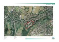
Case Study: Former Croda Site in KilnhurstSWINTONOS map (not to scale)Hatch indicates site areaAerial view of site14
Preparation and Setting OutThe key to good site analysis is to gain an understandingof the context. Then once the context is understood fully,the site is seen in its context. The context analysis is morethan that just beyond the site boundary. On all projects adesigner will:• Reflect on the planning context of the site• Review mapping and plans for the site• Observe surrounding features influencing the siteAn example is to check what is within a reasonable walkingdistance from the site. This could include destinationssuch as:• Public transport routes, bus stops and stations• Open spaces and recreation spaces• Schools• Shops• Community facilities• Land form and water coursesThe site is then analysed to see how it fits the context. Sitefeatures that are useful to study are:• Role of site/context – such as identifying the uses thatwould most suit the locality• Edges – how the site is enclosed or integrated into itssetting• Movement and Access – what are the possibilities forintegration• Townscape – character sensitivities• Open space distribution – is there a lack of or sufficientamenity space• Land use pattern – how mixed or segregated uses aredistributed• Form and Massing – the height and depth of existingbuildings• Solar orientation – how best can this be exploited<strong>DDQ</strong> training 2010 workbook15
View 1 - south west across siteView 2 - north up the canalView 3 - south across the site towards Kilnhurst16
Useful Questions to AskAsking questions about a place is a very useful way ofgaining more from observation. It adds a degree of enquirythat improves understanding. A useful checklist could bebased on a variation of the 20 Building for Life criteria.With slight variations, site questions could be:-Environment and Community• Does the site provide (or is it close to) communityfacilities, such as a school, parks, play areas, shops,pubs or cafes?• Is there potential for an accommodation mix that reflectsthe needs and aspirations of the local community?• Is there potential for a tenure mix that reflects the needsof the local community?• Does the site have easy access to public transport?• Does the site have any features that could reduce itsenvironmental impact?Character• Does the site dictate a specific scheme?• Does the site exploit existing buildings, landscape ortopography?• Does the site have the potential for a place withdistinctive character?• How could the site make it easy to find your wayaround?• Could new streets allow a well-structured buildinglayout?The Site within its Context:CanalSurrounding residential areasThe countrysideTown centre amenitiesThe station and railwayExisting bus routes<strong>DDQ</strong> training 2010 workbook17
The Drawing ImperativeThere are two basic ways to start to draw for urbandesign, one to portray the site in its context including theconstraints upon it, then a second that illustrates the sortof concepts that can be developed for the site. At this level,all drawing will be edited information and this can help toprioritise the ideas being portrayed.The basic structure can be putting marks on a plan thathighlight the important themes. The marks carry ideasthat can later be referred to, discussed and refined.Some drawing can sometimes form the structure for realmasterplan layouts.Drawing where a site sits in its urban context can be veryuseful. It can show routes, local centres, infrastructure andgeography.There are situations where public transport infrastructureare proposed or are already in place. Drawing can illustratethe positive impact of these features. This is becausepublic transport patronage can be enhanced by directingpedestrian flows to these points; in the example shown, theexistence of a mainline railway station.Infrastructure such as railway stations can be enhanced byintegrating them with other public transport such as buses.The concept drawing shows how a bus route might weavethrough a new urban area to exploit the maximum amountof catchment to bus stops. Shading or hatching the urbanarea closest to the route can indicate development thatwould gain the most from this amenity.Drawing the site constraints creates a strongeracknowledgement of contraints in the mind of the designer.Anything can be drawn that is thought to impact on siteorganisation. In this example particular attention is drawn to:• The railway to the west with the dot representing astation• Primary access along the southern boundary• Other potential links to the north• Dashed lines across the site representing servicecorridors such as a cable and gas main• The contours which indicate south facing slopes with abrook forming the base of the valley• Hedgerows crossing the siteUnderstanding a sites edge conditions is vital in order todraw lines that indicates whether an edge is good or bad,or could add or take away value. It allows the designerto ask questions, such as should the edge be masked orexploited when organising building frontages?Drawing the geographic features is useful. These candirectly affect the organisation of the site if seen as worthkeeping. Typically this could include land form, watercourses or tree belts. These could determine the areas thatshould or should not be developed.18
Sketch 01Summary of Analysis:<strong>Workshop</strong> Sketches 01,08 & 10Restricted AccessRailway on EmbankmentIndustrial neighboursPotential contaminationPotential FloodSketch 08The hand drawn concept masterplan is something thatcould emerge from later workshops. This summary drawingshows all the competing themes in one composition. Theintensity around the station, the edges and relationshipto green corridors all contribute to the development ofthe plan and provide the central principles for followingdetailed design development.Sketch 10<strong>DDQ</strong> training 2010 workbook19
<strong>Workshop</strong> Sketch 02Local centre at the most connected nodeA density gradient from high to lowFocal points along the canal edgeBuffer to railway industry<strong>Workshop</strong> Sketch 03Land use zones - light industry office residentialBuffer to south to include open space set offCanal basin at core of the residential zone - placemakingand valuesCanalside open space settng for the office zone20
<strong>Workshop</strong> Sketch 04Central north-south spineHierarchy of primary and secondary routesCentral open space framed by mixed-useBuffer to railway and industry<strong>Workshop</strong> Sketch 05Central north-south spineLarge open space along the canal-sidePredominantly residential with live/work to the south<strong>DDQ</strong> training 2010 workbook21
<strong>Workshop</strong> Sketch 06Provides the maximum number of movement connectionsOpen space setting for the full length of the canalfrontageEmployment uses to add to the landscape buffer at thesouthern boundaryAdditional commercial uses clustered around the canallock<strong>Workshop</strong> sketch 07Highly connected grid of streetsOpened gaps to increase open spaceCentral north south spineHierarchy of primary and secondary routesOpen spaces connect the central spine to the canal sideA focal point in the south east corner22
<strong>Workshop</strong> Sketch 09Broad land use zoning principalsAdditional employment in the south is screened from thecountrysideNorthern access by passing along Walker StreetCanal side open space setting for the office<strong>Workshop</strong> Sketch 11Highly permeable grid with good accessSmall block footprints to suggest buildings rather thanblocksLocal facilities centred on the canal bridgeCurved alignment of buildings to follow the line of thecanalFocal point around the canal lock<strong>DDQ</strong> training 2010 workbook23
<strong>Workshop</strong> sketch 12A permeable grid that maximises developmentOpen space setting for full length of canal sideAdditional road access from the southLinear block along the canal side with views of thecountrysideThe main development blocks denied views of thecountrysideSummary Sketch - Integrating Layers of ThinkingAspiration to connectPotential to block routesExposed edges to good viewsOpen space along the canalThe open grid24
Reflecting on Site PrinciplesOn concluding the hands-on drawing workshop a periodof review and discussion clarified the main themes thatinfluence the development of this particular site. Theseinclude:• All concepts showed the canal-side as an asset. Howthis was expressed varied from group to group. Themost successful ones were based on an open grid withgood east – west circulation and views.• All concepts suggested the neighbouring railway andindustrial land are detrimental to achieving a qualitydesign. Most proposals provided screen planting whilesome went further by adding large off-sets of openspace to the industrial area to the south.• All concepts recognised the single road access pointas a problem. Therefore many schemes showed theaspiration to connect; to the north through the canalbasin, possibly to Walker Street and to the south relyingon the industrial access. The concepts showed all thevariable options for using one, two or three accesspoints, often using a development block to prevent theleast desirable connection.• The limits to road access had influenced ideas aboutland use, with new employment next to existingemployment. In some cases this had resulted in threecul-de-sacs.• All concepts recognised the very linear nature of thesite with its north-south orientation. Therefore mostconcepts expressed a central spine or street thatserviced development parcels on either side.• The central spine and access to canal-side frontagehad allowed some concepts to illustrate an open andhighly permeable grid.• In some, open space was concentrated on the canalfrontage, contributing to the open space setting of thecountryside. In others, the open space was dispersed inpockets throughout the plan.<strong>DDQ</strong> training 2010 workbook25