GPS Spider - Manfra
GPS Spider - Manfra
GPS Spider - Manfra

Create successful ePaper yourself
Turn your PDF publications into a flip-book with our unique Google optimized e-Paper software.
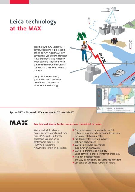
Leica technology<br />
at the MAX<br />
Together with <strong>GPS</strong> <strong>Spider</strong>NET<br />
continuous network processing<br />
and Leica MAX Master Auxiliary<br />
corrections, you achieve increased<br />
RTK performance and reliability<br />
when covering large areas with<br />
a minimum number of reference<br />
stations - it’s the ideal “Win-Win”<br />
situation!<br />
Using Leica SmartStation,<br />
your Total Station can even<br />
benefit from the latest in<br />
Network RTK technology.<br />
<strong>Spider</strong>NET – Network RTK services MAX and i-MAX<br />
MA Raw data and Master Auxiliary corrections transmitted to rovers.<br />
MA<br />
MAX provides full network<br />
master-auxiliary corrections derived<br />
from <strong>GPS</strong> <strong>Spider</strong>NET advanced<br />
processing algorithm in full<br />
conformance with the new<br />
RTCM V3.0 Standard for<br />
Network RTK correction messages.<br />
MA<br />
Compatible rovers can optimally use full<br />
network correction data or decide to use only<br />
the Master station raw data.<br />
Full flexibility for rovers to achieve<br />
optimum performance.<br />
MAXimum network information<br />
over minimum bandwidth.<br />
MAXimum transmission flexibility<br />
using ISDN/PSTN phone or Internet broadcast.<br />
Ideal for broadcast media –<br />
one-way transmission, e.g. using radio modem.<br />
Can serve an unlimited number of rovers.<br />
i<br />
NMEA<br />
-MA<br />
MA<br />
i-<br />
Improved RTK –<br />
Moving with the Standard<br />
Individualized RTK correction data transmitted to the rover.<br />
For i-MAX, the rover provides its<br />
approximate position from which<br />
<strong>Spider</strong>NET identifies the nearest<br />
available reference station.<br />
The Master Auxiliary network<br />
corrections determined for the<br />
network are then applied to provide<br />
individually network corrected RTK<br />
data to the rover. From these<br />
corrections, the rover is then able<br />
to compute higher accuracy RTK<br />
coordinates than with conventional<br />
non-network corrections.<br />
Whichever method is used,<br />
whatever application you have,<br />
longer range, consistent accuracy,<br />
higher reliability and faster RTK<br />
initialization times will increase<br />
your productivity. Using Leica MAX<br />
or i-MAX corrections provides<br />
superior performance over all other<br />
existing known methodsforNetwork<br />
RTK. With Leica MAX users are<br />
at all times in full compliance with the<br />
only industry approved RTCM V3.0<br />
Network RTK Message format –<br />
a Standard jointly driven<br />
by Leica Geosystems - the class<br />
leader in <strong>GPS</strong> Surveying.<br />
Each rover receives its own i-MAX correction<br />
data stream, individualized for its position.<br />
Standard RTK formats, such as RTCM 2.3/3.0 or<br />
Leica proprietary, can be used to transmit network<br />
corrected observation data for the nearest site.<br />
Rovers can benefit from network corrections<br />
without the need to understand RTCM V3.0<br />
Master Auxiliary corrections format.<br />
i-MAX is ideal for supporting legacy <strong>GPS</strong> receivers.<br />
Requires two-way communication using<br />
ISDN / PSTN phones or Internet.