GeoXT handheld
GeoXT handheld
GeoXT handheld

You also want an ePaper? Increase the reach of your titles
YUMPU automatically turns print PDFs into web optimized ePapers that Google loves.
DATASHEET<br />
KEY FEATURES<br />
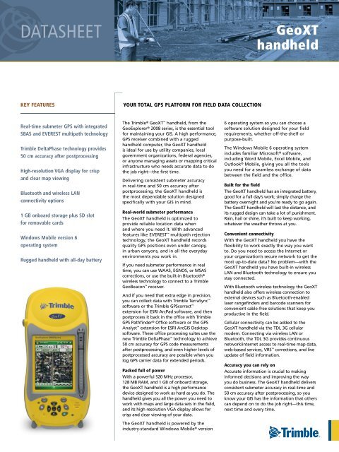
Real-time submeter GPS with integrated<br />
SBAS and EVEREST multipath technology<br />
Trimble DeltaPhase technology provides<br />
50 cm accuracy after postprocessing<br />
High-resolution VGA display for crisp<br />
and clear map viewing<br />
Bluetooth and wireless LAN<br />
connectivity options<br />
1 GB onboard storage plus SD slot<br />
for removable cards<br />
Windows Mobile version 6<br />
operating system<br />
Rugged <strong>handheld</strong> with all-day battery<br />
YOUR TOTAL GPS PLATFORM FOR FIELD DATA COLLECTION<br />
The Trimble ® <strong>GeoXT</strong> <strong>handheld</strong>, from the<br />
GeoExplorer ® 2008 series, is the essential tool<br />
for maintaining your GIS . A high performance,<br />
GPS receiver combined with a rugged<br />
<strong>handheld</strong> computer, the <strong>GeoXT</strong> <strong>handheld</strong><br />
is ideal for use by utility companies, local<br />
government organizations, federal agencies,<br />
or anyone managing assets or mapping critical<br />
infrastructure who needs accurate data to do<br />
the job right—the first time .<br />
Delivering consistent submeter accuracy<br />
in real-time and 50 cm accuracy after<br />
postprocessing, the <strong>GeoXT</strong> <strong>handheld</strong> is<br />
the most dependable solution designed<br />
specifically with your GIS in mind .<br />
Real-world submeter performance<br />
The <strong>GeoXT</strong> <strong>handheld</strong> is optimized to<br />
provide reliable location data when<br />
and where you need it . With advanced<br />
features like EVEREST multipath rejection<br />
technology, the <strong>GeoXT</strong> <strong>handheld</strong> records<br />
quality GPS positions even under canopy,<br />
in urban canyons, and in all the everyday<br />
environments you work in .<br />
If you need submeter performance in real<br />
time, you can use WAAS, EGNOS, or MSAS<br />
corrections, or use the built-in Bluetooth ®<br />
wireless technology to connect to a Trimble<br />
GeoBeacon receiver .<br />
And if you need that extra edge in precision,<br />
you can collect data with Trimble TerraSync <br />
software or the Trimble GPScorrect <br />
extension for ESRI ArcPad software, and then<br />
postprocess it back in the office with Trimble<br />
GPS Pathfinder ® Office software or the GPS<br />
Analyst extension for ESRI ArcGIS Desktop<br />
software . These office processing suites use the<br />
new Trimble DeltaPhase technology to achieve<br />
50 cm accuracy for GPS code measurements<br />
after postprocessing, and even higher levels of<br />
postprocessed accuracy are possible when you<br />
log GPS carrier data for extended periods .<br />
Packed full of power<br />
With a powerful 520 MHz processor,<br />
128 MB RAM, and 1 GB of onboard storage,<br />
the <strong>GeoXT</strong> <strong>handheld</strong> is a high performance<br />
device designed to work as hard as you do . The<br />
<strong>handheld</strong> gives you all the power you need to<br />
work with maps and large data sets in the field,<br />
and its high resolution VGA display allows for<br />
crisp and clear viewing of your data .<br />
The <strong>GeoXT</strong> <strong>handheld</strong> is powered by the<br />
industry-standard Windows Mobile ® version<br />
<strong>GeoXT</strong><br />
<strong>handheld</strong><br />
6 operating system so you can choose a<br />
software solution designed for your field<br />
requirements, whether off-the-shelf or<br />
purpose-built .<br />
The Windows Mobile 6 operating system<br />
includes familiar Microsoft ® software,<br />
including Word Mobile, Excel Mobile, and<br />
Outlook ® Mobile, giving you all the tools<br />
you need for a seamless exchange of data<br />
between the field and the office .<br />
Built for the field<br />
The <strong>GeoXT</strong> <strong>handheld</strong> has an integrated battery,<br />
good for a full day’s work; simply charge the<br />
battery overnight and you’re ready to go again .<br />
The <strong>GeoXT</strong> <strong>handheld</strong> will last the distance, and<br />
its rugged design can take a lot of punishment .<br />
Rain, hail or shine, it’s built to keep working,<br />
whatever the weather throws at you .<br />
Convenient connectivity<br />
With the <strong>GeoXT</strong> <strong>handheld</strong> you have the<br />
flexibility to work exactly the way you want<br />
to . Do you need to access the Internet or<br />
your organization’s secure network to get the<br />
most up-to-date data? No problem—with the<br />
<strong>GeoXT</strong> <strong>handheld</strong> you have built-in wireless<br />
LAN and Bluetooth technology to ensure you<br />
stay connected .<br />
With Bluetooth wireless technology the <strong>GeoXT</strong><br />
<strong>handheld</strong> also offers wireless connection to<br />
external devices such as Bluetooth-enabled<br />
laser rangefinders and barcode scanners for<br />
convenient cable-free solutions that keep you<br />
productive in the field .<br />
Cellular connectivity can be added to the<br />
<strong>GeoXT</strong> <strong>handheld</strong> via the TDL 3G cellular<br />
modem . Connecting via wireless LAN or<br />
Bluetooth, the TDL 3G provides continuous<br />
network/internet access to real-time map data,<br />
web-based services, VRS corrections, and live<br />
update of field information .<br />
Accuracy you can rely on<br />
Accurate information is crucial to making<br />
informed decisions and improving the way<br />
you do business . The <strong>GeoXT</strong> <strong>handheld</strong> delivers<br />
consistent submeter accuracy in real-time and<br />
50 cm accuracy after postprocessing, so you<br />
know your GIS has the information that others<br />
can depend on to do the job right—this time,<br />
next time and every time .
<strong>GeoXT</strong> <strong>handheld</strong><br />
STANDARD FEATURES<br />
System<br />
• Windows Mobile 6 (Classic edition)<br />
• VGA display (480 x 640), sunlight-readable color touchscreen<br />
• Integrated Bluetooth 1.2 wireless technology<br />
• Integrated 802.11b/g wireless LAN<br />
• Ergonomic cable-free <strong>handheld</strong><br />
• Rugged and water-resistant design<br />
• All-day internally rechargeable Li-ion battery<br />
• Marvell 520 MHz XScale processor<br />
• 128 MB RAM<br />
• 1 GB non-volatile Flash data storage<br />
• Sealed SD/SDHC card slot<br />
• Integrated speaker and microphone<br />
GPS<br />
• Integrated high-performance GPS/SBAS1 receiver and L1 antenna<br />
• Submeter real-time or 50 cm postprocessed accuracy<br />
• RTCM and CMR real-time correction support<br />
• TSIP and NMEA protocol support<br />
• EVEREST multipath rejection technology<br />
Standard Software<br />
• GPS Controller for control of integrated GPS and in-field mission planning<br />
• GPS Connector for connecting integrated GPS to external ports<br />
• Microsoft Office Mobile<br />
• Transcriber (handwriting recognition)<br />
Standard Accessories<br />
• Support module<br />
• AC Power supply with International adapter kit<br />
• USB data cable<br />
• Stylus (x 2)<br />
• Screen protectors (2-pack)<br />
• Quick Start Guide<br />
• Getting Started CD<br />
• Hand strap<br />
• Pouch<br />
OPTIONAL FEATURES<br />
Optional Software<br />
• TerraSync software<br />
• Trimble GPScorrect extension for ESRI ArcPad software<br />
• GPS Pathfinder Tools Software Development Kit (SDK)<br />
• GPS Pathfinder Office software<br />
• Trimble GPS Analyst extension for ESRI ArcGIS Desktop software<br />
• TrimPix Pro system<br />
Optional Accessories<br />
• TDL 3G cellular modem accessory<br />
• Power/serial clip (9-pin RS-232 serial connector and power input)<br />
• Vehicle power adaptor2 • Null modem cable2 • Backpack kit<br />
• Hard carry case<br />
• Tempest antenna<br />
• External patch antenna<br />
• Pole-mountable ground plane<br />
• Baseball cap with patch antenna pocket<br />
• 2 meter range pole<br />
• Range pole bracket<br />
• GeoBeacon receiver<br />
• Anti-glare screen protectors (2-pack)<br />
© 2008-2010, Trimble Navigation Limited. All rights reserved. Trimble, the Globe & Triangle logo, GeoExplorer, and<br />
GPS Pathfinder are trademarks of Trimble Navigation Limited, registered in the United States and in other countries.<br />
EVEREST, DeltaPhase, GPS Analyst, GPScorrect, GeoBeacon, <strong>GeoXT</strong>, GPScorrect, Tempest, TerraSync, TrimPix ,and VRS are<br />
trademarks of Trimble Navigation Limited. The Bluetooth word mark and logos are owned by the Bluetooth SIG, Inc.<br />
and any use of such marks by Trimble Navigation Limited is under license. Microsoft, Outlook, and Windows Mobile are<br />
either registered trademarks or trademarks of Microsoft Corporation in the United States and/or other countries. All<br />
other trademarks are the property of their respective owners. PN 022501-164G (03/10)<br />
YOUR LOCAL TRIMBLE OFFICE OR REPRESENTATIVE<br />
TECHNICAL SPECIFICATIONS<br />
Physical<br />
Size . . . . . . . . . . . . . . . . . . . . . . . . . . 21.5 cm × 9.9 cm × 7.7 cm (8.5 in × 3.9 in × 3.0 in)<br />
Weight . . . . . . . . . . . . . . . . . . . . . . . . . . . . . . . . . . . . . . . .0.80 kg (1.76 lbs) with battery<br />
Processor . . . . . . . . . . . . . . . . . . . . . . . . . . . 520 MHz Marvell PXA-270 XScale processor<br />
Memory . . . . . . . . . . . . . . . . . . . . . . . . . .128 MB RAM and 1 GB internal Flash storage<br />
Battery . . . . . . . . . . . . . . . . . . . . . . . . . . . . . . . . . . . . . . . Internal 7500 mAh lithium-ion<br />
27.8 Watt-hours, rechargeable in unit<br />
Power usage<br />
Low (no GPS or backlight) . . . . . . . . . . . . . . . . . . . . . . . . . . . . . . . . . . . . . . . . . . . 1 .8 Watts<br />
Normal (with GPS and backlight 3 ) . . . . . . . . . . . . . . . . . . . . . . . . . . . . . . . . . . . . 2 .6 Watts<br />
High (with GPS, backlight 3 , Bluetooth, and wireless LAN) 4 . . . . . . . . . . . . . . . 3.7 Watts<br />
Environmental<br />
Operating temperature . . . . . . . . . . . . . . . . . . . . . . . –20 ºC to +60 ºC (–4 ºF to 140 ºF)<br />
Storage temperature . . . . . . . . . . . . . . . . . . . . . . . . . –30 ºC to +70 ºC (–22 ºF to 158 ºF)<br />
Casing . . . . . . .Dust-proof and resistant to heavy wind-driven rain per IP 65 standard<br />
Slip-resistant grip, shock and vibration resistant<br />
Drop . . . . . . . . . . . . . . . . . . . . . 1.2 m (4 ft) MIL-STD-810F, Method 516.5, Procedure IV<br />
Input/Output<br />
Expansion . . . . . . . . . . . . . . . . . . . . . . . . . . . . . . SD card slot (SD or SDHC storage cards)<br />
Display . . . . . . . . . . . . 8.9 cm (3.5 in) VGA (480 x 640 pixel) TFT, 16 bit (65,536) colors<br />
LED backlight<br />
Interface . . . . . . . . . . . . . . .Touch screen, 10 hardware control keys, power status LED<br />
Audio system events, warnings, and notifications<br />
Soft Input Panel (SIP) virtual keyboard and handwriting recognition software<br />
Audio . . . . . . . . . . . . . . . . . . . . Microphone and speaker, record and playback utilities<br />
I/O . . . . . . . . . . . . . . . . . . . . . . . . . . . . . . . . . . . . . . . . USB 1.1 client via support module<br />
Serial via optional 9-pin RS-232 power/serial clip adaptor<br />
Radios5 . . . . . . . . . . . . . . . . . . . . . . . . . . . . . . . . .Bluetooth 1 .2, Wireless LAN 802 .11b/g<br />
GPS<br />
Channels . . . . . . . . . . . . . . . . . . . . . . . . . . . . . . . . . . . 14 (12 L1 code and carrier, 2 SBAS)<br />
Integrated real-time . . . . . . . . . . . . . . . . . . . . . . . . . . . . . SBAS1 (dual-channel tracking)<br />
Update rate . . . . . . . . . . . . . . . . . . . . . . . . . . . . . . . . . . . . . . . . . . . . . . . . . . . . . . . . . .1 Hz<br />
Time to first fix . . . . . . . . . . . . . . . . . . . . . . . . . . . . . . . . . . . . . . . . . . 30 seconds (typical)<br />
Protocols<br />
Data output . . . . . . . . . . .TSIP, NMEA-0183 v3.0 (GGA, VTG, GLL, GSA, ZDA, GSV, RMC)<br />
Real-time corrections . . . . . . . . . . . . . . . . . . . . . . . . . . .RTCM 2 .x, RTCM 3 .0, CMR, CMR+<br />
Accuracy (HRMS) 6 after differential correction<br />
Code postprocessed . . . . . . . . . . . . . . . . . . . . . . . . . . . . . . . . . . . . . . . . . . . . . . . . 50 cm<br />
Carrier postprocessed7 With 10 minutes tracking satellites . . . . . . . . . . . . . . . . . . . . . . . . . . . . . . . . . . 20 cm<br />
With 20 minutes tracking satellites . . . . . . . . . . . . . . . . . . . . . . . . . . . . . . . . . . 10 cm<br />
With 45 minutes tracking satellites. . . . . . . . . . . . . . . . . . . . . . . . . . . . . . . . . . . 1 cm<br />
Real-time (SBAS1 or external correction source) . . . . . . . . . . . . . . . . . . . . . . . . Submeter<br />
1 SBAS (Satellite Based Augmentation System). Includes WAAS available in North America only,<br />
EGNOS available in Europe only, and MSAS available in Japan only.<br />
2 Power/serial clip also required.<br />
3 With backlight at default setting (50% brightness).<br />
4 Power draw will vary depending on radio usage.<br />
5 Bluetooth and wireless LAN type approvals are country specific. GeoExplorer 2008 series<br />
<strong>handheld</strong>s have Bluetooth and wireless LAN approval in the U.S. and in most European<br />
countries. For further information please consult your local reseller.<br />
6 Horizontal Root Mean Squared accuracy, 1-sigma (68%). Except in conditions where most GPS<br />
signals are affected by trees, or buildings, or other objects. Except when using VRS corrections,<br />
accuracy varies with proximity to base station by +1 ppm for code postprocessing and real-time.<br />
7 Postprocessed carrier accuracy varies with proximity to base station by +2 ppm. 45 minute<br />
carrier capability applies only to the GPS Pathfinder Office software and is limited to 10km from<br />
the base station.<br />
Specifications subject to change without notice.<br />
NORTH & SOUTH<br />
AMERICA<br />
Trimble Navigation Limited<br />
10355 Westmoor Drive<br />
Suite #100<br />
Westminster, CO 80021<br />
USA<br />
+1-720-587-4574 Phone<br />
+1-720-587-4878 Fax<br />
EUROPE & AFRICA<br />
Trimble Germany GmbH<br />
Am Prime Parc 11<br />
65479 Raunheim<br />
GERMANY<br />
+49-6142-2100-0 Phone<br />
+49-6142-2100-550 Fax<br />
ASIA-PACIFIC & MIDDLE EAST<br />
Trimble Navigation<br />
Singapore PTE Limited<br />
80 Marine Parade Road<br />
#22-06 Parkway Parade<br />
Singapore, 449269<br />
SINGAPORE<br />
+65-6348-2212 Phone<br />
+65-6348-2232 Fax<br />
www.trimble.com<br />
store.trimble.com