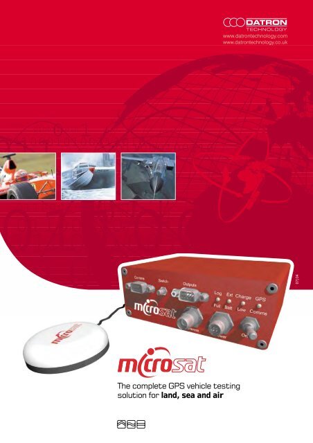
The complete GPS vehicle testing solution for land, sea and air
The complete GPS vehicle testing solution for land, sea and air
The complete GPS vehicle testing solution for land, sea and air

Create successful ePaper yourself
Turn your PDF publications into a flip-book with our unique Google optimized e-Paper software.
0 1<br />
0101001 1 0 1<br />
0100111010<br />
11<br />
01100010100111010<br />
011000100110<br />
011<br />
011000101001110<br />
110001<br />
01100010<br />
11000100110<br />
10<br />
<strong>The</strong> <strong>complete</strong> <strong>GPS</strong> <strong>vehicle</strong> <strong>testing</strong><br />
<strong>solution</strong> <strong>for</strong> <strong>l<strong>and</strong></strong>, <strong>sea</strong> <strong>and</strong> <strong>air</strong><br />
www.datrontechnology.com<br />
www.datrontechnology.co.uk<br />
07|04
NON-CONTACT <strong>GPS</strong> SENSOR<br />
For acquisition of <strong>vehicle</strong> speed, distance travelled,<br />
altitude, heading <strong>and</strong> absolute position.<br />
_ All terrain<br />
_ Non-contact <strong>and</strong> slip free<br />
_ Absolute <strong>GPS</strong> in<strong>for</strong>mation<br />
_ User defined test library<br />
_ Continuous speed <strong>and</strong> distance up to 1,850 km/h<br />
_ Online real-time graphic display via PC <strong>and</strong> Ipaq<br />
_ Onboard data recording via flash memory<br />
_ Outputs include CAN,TTL, etc<br />
For North American sales please contact:<br />
Brent Rijnovean<br />
Brendel Associates Limited<br />
24407 Rock<strong>for</strong>d Street<br />
Dearborn, MI 48124<br />
www.brendelassociates.com<br />
Telephone: (313) 729-9898<br />
Telephone: (313) 278-1872<br />
E-mail: brent@brendelassociates.com<br />
Brendel Associates Limited<br />
Tel: (313) 729-9898<br />
1<br />
01100010100111010101101<br />
01100010100111010<br />
011000100110<br />
01100010<br />
LAND SEA AIR<br />
011<br />
0 1
Contents _<br />
01 _ Microsat delivers the true potential of <strong>GPS</strong><br />
02 _ Easy to setup, easy to use<br />
03 _ How we harness <strong>GPS</strong><br />
07 _ Configure CAN based test systems in just minutes<br />
08 _ <strong>The</strong> MicroSAT advantage<br />
10 _ Speed sensor comparison <strong>testing</strong><br />
11 _ MicroSAT RT software<br />
12 _ Analysis software from 2D<br />
13 _ Enhancements<br />
14 _ Technical specifications<br />
1<br />
01100010100111010101101<br />
01100010100111010<br />
011000100110<br />
01100010<br />
Brendel Associates Limited<br />
Tel: (313) 729-9898 LAND SEA AIR<br />
011<br />
0 1
MicroSAT delivers the true<br />
potential of <strong>GPS</strong> _<br />
<strong>The</strong> innovative new MicroSAT <strong>GPS</strong> sensor from DATRON represents<br />
a major development in the evolution of global positioning technology<br />
<strong>for</strong> dynamic <strong>testing</strong>. As the company that brought you the world's first<br />
non-contact speed <strong>and</strong> distance sensor, Datron Technology is the most<br />
trusted name in the industry – a distinction we continue to earn each<br />
<strong>and</strong> every day with superior instrumentation <strong>and</strong> <strong>solution</strong>s-focused customer<br />
support you know you can depend on. <strong>The</strong> microSAT makes maximum<br />
use of the global positioning system satellites by employing patented PAC<br />
technology to give highly accurate position, distance <strong>and</strong> velocity<br />
measurements, all with unprecedented ease of use. Compact <strong>and</strong> rugged<br />
by design, the MicroSAT Sensor at last delivers the full, uncompromised<br />
potential of global positioning technology – with a level of accuracy<br />
<strong>and</strong> reliability that meets the rigorous st<strong>and</strong>ards of the most trusted name<br />
in <strong>vehicle</strong> <strong>testing</strong> technology – Datron Technology. <strong>The</strong> MicroSAT Sensor<br />
provides high-per<strong>for</strong>mance measurement capabilities <strong>for</strong> virtually<br />
any dynamic <strong>testing</strong> plat<strong>for</strong>m, including automobiles, heavy trucks,<br />
motorcycles, rail <strong>vehicle</strong>s, watercraft <strong>and</strong> even <strong>air</strong>craft. MicroSAT is the<br />
reliable new way to measure:<br />
_ <strong>vehicle</strong> speed<br />
_ distance travelled<br />
_ elapsed time<br />
_ lap times<br />
_ braking distance <strong>and</strong> time<br />
_ acceleration<br />
_ lateral acceleration<br />
_ longitudinal acceleration<br />
_ absolute position<br />
_ height<br />
_ heading<br />
1<br />
01100010100111010101101<br />
01100010100111010<br />
011000100110<br />
01100010<br />
Brendel Associates Limited<br />
Tel: (313) 729-9898<br />
LAND SEA AIR<br />
011<br />
0 1<br />
01
Easy to set-up,<br />
easy to use _<br />
Set-up <strong>and</strong> <strong>testing</strong> have never been easier than with the MicroSAT sensor.<br />
Just make a few simple connections, place the quick-mount <strong>GPS</strong> antenna<br />
on the <strong>vehicle</strong>, <strong>and</strong> within a matter of seconds the MicroSAT sensor is ready<br />
to use. And because the new MicroSAT RT Windows-compatible software<br />
package has been engineered to automate important test functions, dynamic<br />
<strong>testing</strong> becomes a virtually h<strong>and</strong>s-free process. Compared to the MicroSAT<br />
Sensor, anything else always comes up short.<br />
_ Fast, easy set-up takes just seconds.<br />
_ Uses the highest quality <strong>GPS</strong> signals available.<br />
_ Full accuracy on all test surfaces <strong>and</strong> in all atmospheric conditions.<br />
_ Measures speeds from 0 – 1,850 kp/h (0 – 1,152 mph).<br />
_ Measures distance to 0.05% accuracy, with re<strong>solution</strong> to 1 cm.<br />
_ Compact, lightweight, fully ruggedized.<br />
_ Easy connection to laptop via st<strong>and</strong>ard interface.<br />
_ Analogue, digital (TTL pulses) <strong>and</strong> CAN outputs <strong>for</strong> fast, easy<br />
connection to data acquisition.<br />
_ Analogue output <strong>for</strong> quick connection to optional compact display.<br />
_ Internal memory <strong>for</strong> st<strong>and</strong>-alone data logging capability.<br />
_ Aerodynamically inert.<br />
_ Available with optional D<strong>GPS</strong> (differential <strong>GPS</strong>).<br />
_ Test on public highways, tracks, off-road, on water, on rails<br />
<strong>and</strong> in the <strong>air</strong>.<br />
_ 6-18 V DC <strong>vehicle</strong> power supply, internal battery or optional<br />
external power pack.<br />
Brendel Associates Limited<br />
Tel: (313) 729-9898<br />
1<br />
01100010100111010101101<br />
01100010100111010<br />
011000100110<br />
01100010<br />
LAND SEA AIR<br />
011<br />
0 1<br />
02
How does the MicroSAT harness<br />
the power of <strong>GPS</strong>? _<br />
Orbiting the earth there are between 24 <strong>and</strong> 32 <strong>GPS</strong> satellites. <strong>The</strong>ir position<br />
over the earth is constantly changing. <strong>The</strong>y are not in geo-stationary orbits.<br />
Instead they orbit in about 12 hours at a height of about 20000km. In the<br />
normal constellation there are six orbit paths, each one is inclined at 60<br />
degrees relative to the equator. Each path has space <strong>for</strong> 4 satellites, giving<br />
space <strong>for</strong> 24 satellites in a full constellation. Currently there are 27 or 28<br />
satellites in orbit, some of the satellites are extras in case of failures.<br />
Each satellite knows its exact position at any time, this is transmitted<br />
to <strong>GPS</strong> receivers on earth so that we can compute the satellite's position.<br />
<strong>The</strong> details of the satellite's position is called the ephemeris. Due to gravity<br />
variations across the earth the orbit of the satellite changes, so the ephemeris<br />
is adjusted every few hours. Five ground stations are responsible<br />
<strong>for</strong> measuring the precise position of the satellite <strong>and</strong> keeping the <strong>GPS</strong><br />
system accurate.<br />
<strong>The</strong> signal transmitted from each satellite is similar to a spread-spectrum<br />
radio. <strong>The</strong> satellite's data is mixed with a pseudo-r<strong>and</strong>om number sequence.<br />
This sequence is known as the satellite's PRN <strong>and</strong> the sequence is different<br />
<strong>for</strong> each satellite. All the satellites are at the same frequency (1575MHz),<br />
so it is only possible to pick up a <strong>GPS</strong> satellite if you know its PRN sequence.<br />
And if you are tuned to one satellite's PRN then you don't get any in<strong>for</strong>mation<br />
from the other satellites.<br />
<strong>The</strong> clever bit about the <strong>GPS</strong> signals is that the carrier-wave (at 1575MHz)<br />
<strong>and</strong> the PRN sequence are synchronised in time. To pick up the satellite<br />
it is essential to line-up your local copy of the PRN with the satellites; in<br />
carrier-phase tracking receivers (like the MicroSAT) the carrier-wave of the<br />
satellite is also lined up in time with the satellite's carrier-wave; this is essential<br />
<strong>for</strong> good velocity measurement.<br />
Brendel Associates Limited<br />
Tel: (313) 729-9898<br />
1<br />
01100010100111010101101<br />
01100010100111010<br />
011000100110<br />
01100010<br />
LAND SEA AIR<br />
011<br />
0 1<br />
03
Once our <strong>GPS</strong> receiver has lined up its local copy of the PRN with the<br />
satellite then we have some measure of time. But when we have lined up<br />
four or more satellites then we can solve <strong>for</strong> our XYZ position <strong>and</strong> our time<br />
error. Solving <strong>for</strong> the time error is important <strong>for</strong> two different reasons:<br />
A It means that we don't need an atomic clock in our <strong>GPS</strong>. If we had an<br />
atomic clock then we would only need three satellite measurements,<br />
but they are big, power hungry <strong>and</strong> expensive. It is much better to just<br />
use an extra satellite.<br />
B Since we solve <strong>for</strong> our time error it follows that we don't need to calibrate<br />
our timing. If our timing is wrong then it has no effect on the output of<br />
the signals, we still have the same XYZ positions. In other words, if we<br />
did have a calibration problem with our timing, we would end up with<br />
the same measurement. <strong>The</strong> output is independent of our clock.<br />
When more than four satellites are available older receivers chose the best<br />
four <strong>and</strong> computed a position <strong>and</strong> a time. Now we have faster computers<br />
<strong>and</strong> so all the tracked satellites can be used. Using more satellites gives<br />
more immunity to noise. So, generally having 8 satellites is better than<br />
having 6; having 12 satellites is better than having 8.<br />
Quantifying this is possible, but it also depends where the satellites are<br />
in the sky. For instance, if three satellites are very close together then they<br />
only really count as one: their errors are all very similar; any reflections from<br />
trees or buildings are the same <strong>for</strong> all three; any obstructions like buildings,<br />
trees <strong>and</strong> buildings tend to affect all three at the same time. Often<br />
people use the "DOP" (Dilution of Precision) instead of the number of<br />
satellites. This includes in<strong>for</strong>mation about the positions of the satellites as<br />
well as the number of satellites.<br />
Velocity Measurement<br />
<strong>The</strong> term "Doppler Shift" has been used a lot in relation to obtaining accurate<br />
velocity measurements from <strong>GPS</strong>. <strong>The</strong> term is used loosely, there is no<br />
method of signal processing that can possibly measure the Doppler Shift<br />
of a <strong>GPS</strong> satellite directly. All measurements are per<strong>for</strong>med by a filter<br />
(invariably a kalman filter) in the <strong>GPS</strong> receiver.<br />
Brendel Associates Limited<br />
Tel: (313) 729-9898<br />
1<br />
01100010100111010101101<br />
01100010100111010<br />
011000100110<br />
01100010<br />
LAND SEA AIR<br />
011<br />
0 1<br />
04
As the <strong>vehicle</strong> <strong>and</strong> the satellite move in relation to each other the time delay<br />
of the signal from the satellite changes. <strong>The</strong> <strong>GPS</strong> receiver has to continually<br />
change its local carrier-phase <strong>and</strong> PRN timing. If the local timing shifts<br />
away from the ideal position then the strength of the signal reduces <strong>and</strong><br />
the <strong>GPS</strong> receiver cannot track it as well.<br />
To track the signal accurately the <strong>GPS</strong> receiver makes excellent use of this.<br />
Since the signal strength reduces if the local PRN is wrong, a good option<br />
is to keep TWO copies of the PRN in the local <strong>GPS</strong>. <strong>The</strong>se are positioned<br />
so that one is just behind the satellite <strong>and</strong> the other is just ahead of the<br />
satellite. If <strong>GPS</strong> receiver moves closer to the satellite then the "just behind"<br />
signal increases <strong>and</strong> the "just ahead" signal decreases. <strong>The</strong> <strong>GPS</strong> receiver<br />
can compare the strength of these two signals <strong>and</strong> keep itself accurately<br />
locked to the correct time.<br />
One essential measurement used when tracking the <strong>GPS</strong> signals is a term<br />
in the kalman filter which represents the velocity of the satellite compared<br />
to the local <strong>GPS</strong> receiver. This term is called the Doppler Shift. It is essential<br />
because the satellites have velocities of about 10000km/h. If the<br />
Doppler Shift is not tracked then it is impossible to keep track of the<br />
Carrier-Phase <strong>and</strong> the PRN.<br />
<strong>The</strong>re is a choice that <strong>GPS</strong> manufacturers have to make regarding<br />
the dynamics of the <strong>vehicle</strong> <strong>and</strong> the noise of the velocity. A <strong>GPS</strong> receiver<br />
that can track higher accelerations <strong>and</strong> higher jerk rates is noisier.<br />
A compromise between noise <strong>and</strong> tracking has to be made by all<br />
<strong>GPS</strong> manufacturers.<br />
All measurement systems can reduce their noise by reducing their b<strong>and</strong>width<br />
<strong>and</strong> <strong>GPS</strong> is no exception to this. <strong>The</strong> noise, tracking <strong>and</strong> b<strong>and</strong>width are all<br />
related. A <strong>GPS</strong> receiver with a 1Hz b<strong>and</strong>width has a lower noise than a 5Hz<br />
<strong>GPS</strong> receiver, but it cannot track fast changes to acceleration (like the end<br />
of a brake test). From the underlying physics 10Hz b<strong>and</strong>width is about the<br />
limit of what <strong>GPS</strong> can provide, beyond this the noise makes measurements<br />
guess-work. A 20Hz <strong>GPS</strong> receiver can capture all the in<strong>for</strong>mation that <strong>GPS</strong><br />
can provide.<br />
Brendel Associates Limited<br />
Tel: (313) 729-9898<br />
1<br />
01100010100111010101101<br />
01100010100111010<br />
011000100110<br />
01100010<br />
LAND SEA AIR<br />
011<br />
0 1<br />
05
Distance <strong>and</strong> <strong>GPS</strong><br />
Interestingly enough, the tracking process of <strong>GPS</strong> lends itself to accurate<br />
distance measurement, especially in open sky environments. <strong>The</strong> shift in<br />
the PRN <strong>and</strong> the change in the carrier-phase is a direct measure of the<br />
distance shift between the satellite <strong>and</strong> the <strong>vehicle</strong>. <strong>The</strong> carrier-phase<br />
measurements give excellent short-term position measurements. Drift of<br />
about 1m over a 10-minute period are typical in high-multipath environments;<br />
in open-sky 1m over a hour is more typical.<br />
Differential <strong>GPS</strong><br />
It is f<strong>air</strong> to say that Differential <strong>GPS</strong> has little (or zero) effect on accurate<br />
velocity measurement. <strong>The</strong>re is evidence to suggest that Differential<br />
<strong>GPS</strong> can increase the noise in some circumstances (<strong>for</strong> example, if there<br />
is multipath at the base-station).<br />
Velocity measurements are made almost exclusively by observations of<br />
carrier-phase. Knowing that your carrier-phase is drifting by 1m (about 5<br />
cycles) in 10 minutes would give you a correction of 0.006km/h. This is<br />
much smaller than the noise <strong>and</strong> wholey irrelevant to accurate velocity<br />
measurement. If your <strong>GPS</strong> receiver needs D<strong>GPS</strong> to measure velocity then<br />
there is something else wrong with it.<br />
(When the US government was deliberately degrading <strong>GPS</strong> then their policy<br />
was to impose a carrier-phase drift equivalent to about 1m/s. So prior to<br />
Selective Availability being turned off, D<strong>GPS</strong> helped velocity considerably.<br />
Many <strong>GPS</strong> manufacturers still have not tested their <strong>GPS</strong> cards, nor have<br />
they revised their documentation.)<br />
Brendel Associates Limited<br />
Tel: (313) 729-9898<br />
1<br />
01100010100111010101101<br />
01100010100111010<br />
011000100110<br />
01100010<br />
LAND SEA AIR<br />
011<br />
0 1<br />
06
Configure <strong>complete</strong> CAN based<br />
test systems in just minutes _<br />
Compact components make set-up fast <strong>and</strong> easy<br />
_ Displays – multiple units can be connected simultaneously<br />
<strong>for</strong> the display of numerous values.<br />
_ Online calculation units – <strong>for</strong> virtual channels.<br />
_ Memory units – available <strong>for</strong> CAN modules.<br />
_ Data loggers – wide variety of options available.<br />
_ Interface units <strong>The</strong>rmocouple amplifiers, Strain-gauge amplifiers,<br />
Analogue inputs / outputs <strong>and</strong> CAN to CAN, CAN to analogue,<br />
analogue to CAN...<br />
<strong>The</strong> advantages of the Datron modular, CAN-based <strong>testing</strong> system<br />
_ Greater flexibility.<br />
_ Compact, light weight components – Datron offers a <strong>complete</strong><br />
range of compact, lightweight CAN-based components designed<br />
to streamline test set-up <strong>and</strong> ensure consistent <strong>and</strong> reliable data.<br />
_ Fewer cables – a <strong>complete</strong> CAN-bus network can be configured<br />
with just 5 cables. A comparable configuration using traditional<br />
data logger technology requires as much as 18.<br />
_ Unlimited scalability <strong>and</strong> easy connection – a nearly unlimited<br />
number of CAN modules can be connected to the network, providing<br />
unprecedented scalability <strong>and</strong> ease of use.<br />
_ Massive input capability – current CAN architecture accommodates<br />
up to 256 channels<br />
Brendel Associates Limited<br />
Tel: (313) 729-9898<br />
1<br />
01100010100111010101101<br />
01100010100111010<br />
011000100110<br />
01100010<br />
MICROSAT<br />
DATA LOGGERS<br />
ANALOG INPUTS<br />
THERMOCOUPLE INPUTS<br />
STRAIN-GAUGE INPUTS<br />
SPECIAL INTERFACE UNITS<br />
COMPACT DISPLAY<br />
COMPACT DISPLAY<br />
LAND SEA AIR<br />
011<br />
0 1<br />
07
<strong>The</strong> MicroSAT advantage _<br />
Why is the MicroSAT Global Positioning Sensor the logical choice <strong>for</strong> your<br />
dynamic <strong>testing</strong> needs? <strong>The</strong> answer is simple: superior per<strong>for</strong>mance <strong>and</strong><br />
reliability. MicroSAT is the product of an extensive re<strong>sea</strong>rch <strong>and</strong> development<br />
process, focused on the real-world dem<strong>and</strong>s of dynamic <strong>vehicle</strong> <strong>testing</strong>.<br />
With over two decades of intensive involvement in non-contact measurement<br />
of dynamic <strong>vehicle</strong> per<strong>for</strong>mance characteristics, Datron Technology Sensor<br />
systems offers a level of expertise <strong>and</strong> depth of experience that is unrivaled<br />
in the industry. <strong>The</strong> MicroSAT Sensor provides a new option in non-contact<br />
measurement that draws upon this experience to deliver a truly viable new<br />
tool that combines exceptional ease of use with outst<strong>and</strong>ing measurement<br />
accuracy <strong>and</strong> reliability. With per<strong>for</strong>mance that satisfies the most dem<strong>and</strong>ing<br />
applications <strong>and</strong> rugged reliability that st<strong>and</strong>s up to the rigors of racing<br />
<strong>and</strong> refinement <strong>testing</strong>, MicroSAT makes dynamic measurement faster,<br />
easier <strong>and</strong> more productive. Discover the difference. Put MicroSAT to<br />
the test. <strong>The</strong>re’s no better way to discover the many advantages of the<br />
MicroSAT <strong>GPS</strong> Sensor than to test one yourself. We’re confident you’ll get<br />
better data, <strong>and</strong> do so without the aggravation of signal loss, mechanical<br />
failure <strong>and</strong> other anomalous behaviours. MicroSAT, like every product<br />
we offer, is better because it works.<br />
MicroSAT, like every product we offer, is better because it works. <strong>The</strong><br />
MicroSAT is only part of our speed sensor range which comprises of Optical<br />
<strong>and</strong> Microwave based technologies, the graph on the page 09 shows a<br />
good correlation between our sensors during a brake test.<br />
*Circular Error Probability (CEP) is defined as the diameter of a circle in which 50% of all readings occur.<br />
Brendel Associates Limited<br />
Tel: (313) 729-9898<br />
1<br />
01100010100111010101101<br />
01100010100111010<br />
011000100110<br />
01100010<br />
LAND SEA AIR<br />
011<br />
0 1<br />
08
<strong>The</strong> modular range of Datron sensors are as follows:<br />
_ New Optical 1 Axis: L-400 2 Axis: S-400<br />
_ Old Optical Technology (<strong>for</strong> in<strong>for</strong>mation) 2 Axis: S-CE<br />
_ Microwave: Microstar<br />
Datron will endeavour to supply you with the best sensor <strong>for</strong> your <strong>testing</strong><br />
applications <strong>and</strong> in the event that you require a different sensor <strong>for</strong> a one<br />
off test we offer a comprehensive hire service<br />
Brendel Associates Limited<br />
Tel: (313) 729-9898<br />
1<br />
01100010100111010101101<br />
01100010100111010<br />
011000100110<br />
01100010<br />
LAND SEA AIR<br />
011<br />
0 1<br />
09
01100010100111010101101<br />
01100010100111010<br />
Speed Sensor Comparison Testing _<br />
Report Summary 30th April 2004<br />
<strong>The</strong>re is much confusion in the motor industry about which speed/distance<br />
measuring systems are the most accurate <strong>and</strong> which systems work best<br />
<strong>for</strong> particular tests. In reality it is not quite as black <strong>and</strong> white as the<br />
manufacturers tell you. This report aims to clarify the subject <strong>and</strong> allow test<br />
engineers to make in<strong>for</strong>med decisions about the selection of systems<br />
<strong>for</strong> specific applications. It is also hoped that as a result of this report the<br />
manufacturers will be more open about their products, they will let people<br />
know the strengths <strong>and</strong> weaknesses of their systems leading to much less<br />
confusion <strong>for</strong> the engineers. In time this may lead the way to universally<br />
accepted methods of <strong>testing</strong> <strong>and</strong> analysing test results, which can only be<br />
a good thing <strong>for</strong> the transport industry. <strong>The</strong> report gives details of tests <strong>and</strong><br />
results of an exercise conducted by Rob Marshall Engineering Ltd. on<br />
behalf of Datron Technology UK Ltd.<br />
<strong>The</strong> exercise consisted of:<br />
A comparison of commercially available speed/distance measuring<br />
equipment used by <strong>vehicle</strong> manufacturers <strong>and</strong> design consultancies when<br />
working on new <strong>and</strong> existing <strong>vehicle</strong>s. Tests were primarily brake tests <strong>and</strong><br />
concentrated on the issues of consistency, signal loss <strong>and</strong> total latency<br />
within the sensors <strong>and</strong> equipment <strong>and</strong> its effect on stopping distance.<br />
Four main conclusions can be drawn from the tests:<br />
1 All systems tested are subject to significant <strong>and</strong> differing levels of latency.<br />
2 <strong>The</strong>re is a considerable difference in per<strong>for</strong>mance of optical sensors<br />
depending on the track condition – they are adversely affected in the<br />
wet <strong>and</strong> were subject to signal loss.<br />
3 <strong>GPS</strong> based systems per<strong>for</strong>m equally well in dry <strong>and</strong> wet conditions<br />
however, the total latency effects are greatest on <strong>GPS</strong> systems leading<br />
to less accurate results.<br />
4 <strong>GPS</strong> based systems gave more repeatable results but only when there<br />
was sufficient satellite coverage.<br />
<strong>The</strong> full report can be downloaded at www.datrontechnology.co.uk/site/download.php<br />
Brendel Associates Limited<br />
Tel: (313) 729-9898<br />
1<br />
011000100110<br />
01100010<br />
LAND SEA AIR<br />
011<br />
0 1<br />
10
MicroSAT RT Software provides<br />
powerful Real Time <strong>testing</strong> capability _<br />
MicroSAT RT real-time software provides a convenient, easy-to-use interface<br />
to the MicroSAT Sensor. It displays data output by the sensor <strong>and</strong> computes<br />
a variety of per<strong>for</strong>mance parameters required <strong>for</strong> <strong>vehicle</strong> <strong>testing</strong>. MicroSAT<br />
RT software can also be configured to automatically per<strong>for</strong>m a series<br />
of tests when the sensor is powered on. All data is stored automatically as<br />
detailed spreadsheet files <strong>and</strong> can be saved <strong>for</strong> postest replay <strong>and</strong> analysis.<br />
_ Measure, record <strong>and</strong> display <strong>vehicle</strong> velocity, distance, time,<br />
acceleration, braking <strong>and</strong> position data.<br />
_ View measured values in <strong>for</strong>mats that allow you to quantify <strong>vehicle</strong><br />
per<strong>for</strong>mance in easily recognisable terms.<br />
_ Tabulated <strong>and</strong> graphical data.<br />
_ Measure braking per<strong>for</strong>mance (brake switch included).<br />
_ Per<strong>for</strong>m acceleration tests, either from st<strong>and</strong>still<br />
or as an in-gear test when moving.<br />
_ Design custom tests with user-definable parameter<br />
<strong>and</strong> trigger settings.<br />
_ Create track maps <strong>for</strong> analysis of driving lines. This capability<br />
is particularly valuable in competition applications. Lap times can<br />
be compared to specific driving lines to optimise driver per<strong>for</strong>mance<br />
in competition <strong>and</strong> time-trials.<br />
_ Produce maps of the actual route followed by the <strong>vehicle</strong> during<br />
the test. Routes can also be displayed in real time on available<br />
digitized scale maps.<br />
_ Measure lap times with user-definable start-stop lines.<br />
_ Thorough analysis of every aspect of saved data.<br />
_ Select data segmants <strong>for</strong> even more in-depth analysis.<br />
Brendel Associates Limited<br />
Tel: (313) 729-9898<br />
1<br />
01100010100111010101101<br />
01100010100111010<br />
011000100110<br />
01100010<br />
LAND SEA AIR<br />
011<br />
0 1<br />
11
Analysis software from 2D _<br />
<strong>The</strong> software is a cut down version of the race proven 2D ‘Analyser’ software<br />
specially modified <strong>for</strong> the MicroSat. <strong>The</strong> new software takes the raw data<br />
files that the MicroSat creates to produce graphical <strong>and</strong> tabulated data.<br />
This software allows you to per<strong>for</strong>m:<br />
_ Analyse raw microSat R1 files<br />
_ Toggle between graphical <strong>and</strong> tabulated results<br />
_ Per<strong>for</strong>mance Tables e.g. Accel &/or Braking easily configured<br />
_ Overlay graphical data, car to car, lap to lap etc. Whatever you desire<br />
_ Create <strong>and</strong> save trackmaps automatically from <strong>GPS</strong> data<br />
_ Start/Finish line automatically identified by new algorithm – Lap<br />
Beacon not required.<br />
_ Analyse lap <strong>and</strong> section speeds & times<br />
_ Identify fastest lap &/or section<br />
_ Profile track position against <strong>vehicle</strong> speed<br />
_ Export whole or partial data<br />
This offers a lead-in to the extensive range of 2D data-logging & signal<br />
conditioning modules which can easily be added at any time.<br />
Download a Sample file at: http://www.ots.ndirect.co.uk/2D/Demo2.exe<br />
<strong>The</strong> software is free, please contact us <strong>and</strong> we will send you a CD.<br />
Brendel Associates Limited<br />
Tel: (313) 729-9898<br />
1<br />
01100010100111010101101<br />
01100010100111010<br />
011000100110<br />
01100010<br />
upgrade required <strong>for</strong> video option<br />
LAND SEA AIR<br />
011<br />
0 1<br />
12
Enhancements _<br />
IPAQ with Enginuity-Lite<br />
For the ever increasing health & safety requirements of proving grounds<br />
we have utilised the IPAQ palm PC to give the driver an easy to read display<br />
which will also log <strong>and</strong> display your test data. <strong>The</strong> IPAQ has a cut down<br />
version of the RT software called Enginuity-Lite that enables you to quickly<br />
do your tests. This software allows you to do:<br />
_ Brake Tests<br />
_ Acceleration Tests<br />
_ Raw Logging (R1 file)<br />
<strong>The</strong> R1 datafile can be replayed in the full RT version. (Note: the IPAQ needs<br />
to have a serial port). In the event that you want to use both the laptop <strong>and</strong><br />
the IPAQ a ‘serial splitter’ cable is available to feed both systems at the<br />
same time. Please contact us if you require the IPAQ software.<br />
High speed radio modem<br />
For remote operation of the MicroSat sensor.<br />
<strong>The</strong> radio modems have been developed to transfer data via RS-232. <strong>The</strong>re<br />
are two units that are used, one receiver & one transmitter. <strong>The</strong> transmitter<br />
is connected to the microSat ‘comms’ <strong>and</strong> the receiver is connected<br />
to the serial port of the laptop which can be at a remote location. <strong>The</strong><br />
microSat software can now be operated remotely just as if you were inside<br />
the test <strong>vehicle</strong>. Ideal <strong>for</strong> tests where you don’t want a laptop onboard<br />
e.g.h<strong>and</strong>ling or tyre tests.<br />
Brendel Associates Limited<br />
Tel: (313) 729-9898<br />
1<br />
01100010100111010101101<br />
01100010100111010<br />
011000100110<br />
01100010<br />
LAND SEA AIR<br />
011<br />
0 1<br />
13
Technical specifications _<br />
VELOCITY<br />
Accuracy 0.1 kph<br />
Units kph or mph<br />
Update rate 20 Hz<br />
Maximum velocity 1,850 kph<br />
Minimum velocity 0.1 kph<br />
Re<strong>solution</strong> 0.01 kph<br />
DISTANCE<br />
Accuracy 0.05% (