Atmospheric circulation over the Bolivian Altiplano during ... - CDAM
Atmospheric circulation over the Bolivian Altiplano during ... - CDAM
Atmospheric circulation over the Bolivian Altiplano during ... - CDAM

Create successful ePaper yourself
Turn your PDF publications into a flip-book with our unique Google optimized e-Paper software.
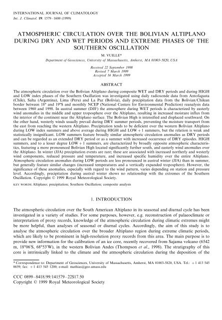
INTERNATIONAL JOURNAL OF CLIMATOLOGYInt. J. Climatol. 19: 1579–1600 (1999)ATMOSPHERIC CIRCULATION OVER THE BOLIVIAN ALTIPLANODURING DRY AND WET PERIODS AND EXTREME PHASES OF THESOUTHERN OSCILLATIONM. VUILLE*Department of Geosciences, Uniersity of Massachusetts, Amherst, MA 01003-5820, USAReceied 22 September 1998Reised 7 March 1999Accepted 16 March 1999ABSTRACTThe atmospheric <strong>circulation</strong> <strong>over</strong> <strong>the</strong> <strong>Bolivian</strong> <strong>Altiplano</strong> <strong>during</strong> composite WET and DRY periods and <strong>during</strong> HIGHand LOW index phases of <strong>the</strong> Sou<strong>the</strong>rn Oscillation was investigated using daily radiosonde data from Antofagasta(Chile), Salta (Argentina), Lima (Peru) and La Paz (Bolivia), daily precipitation data from <strong>the</strong> <strong>Bolivian</strong>/Chileanborder between 18° and 19°S and monthly NCEP (National Centers for Environmental Prediction) reanalysis databetween 1960 and 1998. In austral summer (DJF) <strong>the</strong> atmosphere <strong>during</strong> WET periods is characterized by easterlywind anomalies in <strong>the</strong> middle and upper troposphere <strong>over</strong> <strong>the</strong> <strong>Altiplano</strong>, resulting in increased moisture influx from<strong>the</strong> interior of <strong>the</strong> continent near <strong>the</strong> <strong>Altiplano</strong> surface. The <strong>Bolivian</strong> High is intensified and displaced southward. On<strong>the</strong> o<strong>the</strong>r hand, westerly winds usually prevail <strong>during</strong> DRY summer periods, preventing <strong>the</strong> moisture transport from<strong>the</strong> east from reaching <strong>the</strong> western <strong>Altiplano</strong>. Precipitation tends to be deficient <strong>over</strong> <strong>the</strong> western <strong>Bolivian</strong> <strong>Altiplano</strong><strong>during</strong> LOW index summers and above average <strong>during</strong> HIGH and LOW+1 summers, but <strong>the</strong> relation is weak andstatistically insignificant. LOW summers feature broadly similar atmospheric <strong>circulation</strong> anomalies as DRY periodsand can be regarded as an extended DRY period or as a summer with increased occurrence of DRY episodes. HIGHsummers, and to a lesser degree LOW+1 summers, are characterized by broadly opposite atmospheric characteristics,featuring a more pronounced <strong>Bolivian</strong> High located significantly fur<strong>the</strong>r south, and easterly wind anomalies <strong>over</strong><strong>the</strong> <strong>Altiplano</strong>. In winter (JJA) precipitation events are rare; <strong>the</strong>se are associated with increased nor<strong>the</strong>rly and westerlywind components, reduced pressure and temperature, and increased specific humidity <strong>over</strong> <strong>the</strong> entire <strong>Altiplano</strong>.<strong>Atmospheric</strong> <strong>circulation</strong> anomalies <strong>during</strong> LOW periods are less pronounced in austral winter (JJA) than in summer,but generally feature similar changes (increased temperatures and a vertically expanded troposphere). However, <strong>the</strong>significance of <strong>the</strong>se anomalies, especially with regard to <strong>the</strong> wind pattern, varies depending on station and pressurelevel. Accordingly, precipitation <strong>during</strong> austral winter shows no relationship with <strong>the</strong> extremes of <strong>the</strong> Sou<strong>the</strong>rnOscillation. Copyright © 1999 Royal Meteorological Society.KEY WORDS: <strong>Altiplano</strong>; precipitation; Sou<strong>the</strong>rn Oscillation; composite analysis1. INTRODUCTIONThe atmospheric <strong>circulation</strong> <strong>over</strong> <strong>the</strong> South American <strong>Altiplano</strong> in its seasonal and diurnal cycle has beeninvestigated in a variety of studies. For some purposes, however, e.g. reconstruction of palaeoclimate orinterpretation of proxy records, knowledge of <strong>the</strong> atmospheric <strong>circulation</strong> <strong>during</strong> climatic extremes mightbe more helpful, than analyses of seasonal or diurnal cycles. Accordingly, <strong>the</strong> aim of this study is toanalyse <strong>the</strong> atmospheric <strong>circulation</strong> <strong>over</strong> <strong>the</strong> broader <strong>Altiplano</strong> region <strong>during</strong> extreme climatic periods,which are likely to be prominent in high-resolution proxy records from this area. The main purpose is toprovide new information for <strong>the</strong> calibration of an ice core, recently rec<strong>over</strong>ed from Sajama volcano (6542m, 18°06S, 68°53W), in <strong>the</strong> western <strong>Bolivian</strong> Andes (Thompson et al., 1998). The stratigraphy of thiscore is intrinsically linked to <strong>the</strong> climate and <strong>the</strong> atmospheric <strong>circulation</strong> <strong>during</strong> <strong>the</strong> deposition of <strong>the</strong>* Correspondence to: Department of Geosciences, University of Massachusetts, Amherst, MA 01003-5820, USA. Tel.: +1 413 5450659; fax: +1 413 545 1200; e-mail: mathias@geo.umass.eduCCC 0899–8418/99/141579–22$17.50Copyright © 1999 Royal Meteorological Society
1580M. VUILLEsnow (Hardy et al., 1998). Therefore, <strong>the</strong> main emphasis of this study is on extended dry and wet periodsand <strong>the</strong> El Niño–Sou<strong>the</strong>rn Oscillation phenomenon (ENSO), which has been identified in o<strong>the</strong>r palaeorecords from tropical Andean ice cores (Thompson et al., 1984).Sajama Volcano is <strong>the</strong> highest peak in Bolivia, located in <strong>the</strong> western Andean Cordillera in closestproximity to <strong>the</strong> Chilean border (Figure 1). The Andes is split up into an eastern and a western rangebetween 15°S and 22°S, encompassing a large intramontane plateau, <strong>the</strong> <strong>Altiplano</strong>, with a mean height of3500–4000 m. With its height extending into <strong>the</strong> middle troposphere, <strong>the</strong> Central Andes act as a barrier,effectively separating low level <strong>circulation</strong> to <strong>the</strong> east and west of <strong>the</strong> mountain range (see Figure 2(a) and(d)). To <strong>the</strong> west, <strong>the</strong> Sou<strong>the</strong>ast Pacific Anticyclone produces dry and stable conditions with subsiding airmasses, and moist air remains trapped below <strong>the</strong> very stable inversion at about 900 hPa, resulting in <strong>the</strong>world’s driest climate along <strong>the</strong> north Chilean coast. To <strong>the</strong> east, in <strong>the</strong> interior of <strong>the</strong> continent, a <strong>the</strong>rmalheat low (Chaco low) develops <strong>during</strong> <strong>the</strong> summer months and <strong>the</strong> lower troposphere is characterized bywarm and humid conditions. Sajama volcano is located in between <strong>the</strong>se two distinct climatic patterns,experiencing varying influences from both sides of <strong>the</strong> Andes, depending upon <strong>the</strong> prevailing <strong>circulation</strong>.Precipitation on <strong>the</strong> <strong>Altiplano</strong> is associated with strong summer convection and daily moisture influx from<strong>the</strong> eastern interior of <strong>the</strong> continent (Fuenzalida and Ruttlant, 1987; Horel et al., 1989; Garreaud andWallace, 1997; Vuille et al., 1998; Garreaud, 1999). More than 80% of <strong>the</strong> annual precipitation (350–400mm) falls <strong>during</strong> <strong>the</strong> summer months December–March (Hardy et al., 1998; Vuille et al., 1998). Theintense solar heating of <strong>the</strong> <strong>Altiplano</strong> surface destabilizes <strong>the</strong> boundary layer, induces deep convection andfinally releases <strong>the</strong> moisture advected from <strong>the</strong> east <strong>during</strong> typical afternoon and evening showers(Garreaud, 1999). However, <strong>the</strong> episodic nature of precipitation on <strong>the</strong> <strong>Altiplano</strong> shows that while solarheating might be a prerequisite, additional forcing is necessary for precipitation to occur. Several authorshave emphasized <strong>the</strong> crucial role played by <strong>the</strong> upper-air <strong>circulation</strong> in <strong>the</strong> timing and duration ofprecipitation events. Jacobeit (1992) has shown that upper-air divergence or easterly disturbances are <strong>the</strong>dominant pattern associated with precipitation periods <strong>over</strong> <strong>the</strong> <strong>Altiplano</strong>. Upper-air divergence is mostlyassociated with a high pressure system, a closed anticyclone named <strong>the</strong> <strong>Bolivian</strong> High due to itsclimatological mean position <strong>over</strong> Bolivia in summer months (Schwerdtfeger, 1961; Virji, 1981). In Figure2(b) and (c) <strong>the</strong> anticyclonic rotation about <strong>the</strong> high is clearly visible in <strong>the</strong> 500 and 200 hPa geopotentialheight and wind field. Many of <strong>the</strong> transient features of this <strong>Bolivian</strong> High could be reproduced by SilvaFigure 1. Map of <strong>the</strong> study area with location of Sajama Volcano (6542 m, 18°06S, 68°53W) and radiosonde stations. <strong>Altiplano</strong>(area above 3000 m) is shadedCopyright © 1999 Royal Meteorological Society Int. J. Climatol. 19: 1579–1600 (1999)
1584M. VUILLETable II. HIGH (SOI1), LOW (SOI−2) and LOW+1 (DJF following a LOW episode andSOI−1) index years for DJF and JJA (HIGH and LOW only)PeriodEvents(a) DJFLOW 1958–1959, 1972–1973, 1977–1978, 1982–1983, 1986–1987, 1991–1992, 1997–1998LOW+1 1959–1960, 1973–1974, 1978–1979, 1983–1984, 1987–1988, 1993–1994HIGH 1961–1962, 1966–1967, 1970–1971, 1973–1974, 1975–1976, 1988–1989, 1996–1997(b) JJALOW 1965, 1972, 1977, 1982, 1987, 1993, 1994, 1997HIGH 1964, 1973, 1975, 1981, 1988, 1996Periods in bold are c<strong>over</strong>ed by radiosonde data only, periods in italics by NCEP reanalysis data only.includes periods when all stations recorded at least 0.5 mm day −1 <strong>over</strong> five or more consecutive days(DJF), or <strong>over</strong> at least 2 days (JJA). This differentiation between DJF and JJA was necessary becauseprecipitation is very rare, and of short duration, <strong>during</strong> <strong>the</strong> winter months—no events would have met<strong>the</strong> 5 day summer criteria. DRY includes all periods of at least 5 days without precipitation at all stations(for both DJF and JJA). This procedure yielded 475 (425) days for WET (DRY) in DJF and 140 (2416)days for WET (DRY) in JJA between 1960 and 1993.The corresponding data for WET and DRY were <strong>the</strong>n extracted from <strong>the</strong> upper-air sounding recordsfor both DJF and JJA. However, only <strong>the</strong> records from Antofagasta, Lima and Salta c<strong>over</strong> most of <strong>the</strong>WET and DRY periods, as <strong>the</strong> La Paz record is considerably shorter (Table I). Arithmetic means andstandard deviations were computed for each parameter and a two-tailed Student’s t-test was performedin order to evaluate significant differences in <strong>the</strong> atmospheric variables <strong>during</strong> DRY and WET periods forboth <strong>the</strong> summer (DJF) and winter (JJA) months.The same analysis was also applied to <strong>the</strong> NCEP reanalysis data, however on a monthly basis.Composites were built for all summers (DJF) when precipitation records near Sajama indicate anomaliesabove (WET) or below (DRY) one standard deviation, compared to <strong>the</strong> long-term mean. This procedureyielded four wet summers (1971–1972, 1972–1973, 1974–1975 and 1985–1986) forming <strong>the</strong> NCEP WETcomposite, and four dry summers (1965–1966, 1982–1983, 1989–1990 and 1991–1992) forming <strong>the</strong>NCEP DRY composite. This analysis was applied to austral summer only, since <strong>the</strong> temporal resolutionof <strong>the</strong> monthly NCEP data used in this study would not allow to resolve <strong>the</strong> few and rare winterprecipitation events, preceded and followed by extended dry periods.Besides <strong>the</strong> classification into WET and DRY, both <strong>the</strong> CARDS and <strong>the</strong> NCEP data were alsoanalysed as a function of HIGH and LOW index phases of <strong>the</strong> Sou<strong>the</strong>rn Oscillation (standardizedpressure difference between Tahiti and Darwin, using 1951–1980 as base period) obtained from <strong>the</strong>Climate Prediction Center (NOAA-CPC). Three-monthly SOI averages were computed for DJF and JJAand all periods for which SOI1 (HIGH) and SOI −2 (LOW) were retained. The selected HIGH andLOW index phases for DJF and JJA are listed in Table II. The thresholds of 1 and −2 for <strong>the</strong>standardized SOI anomalies are somewhat arbitrary but yielded an equal number of seven strong HIGHand LOW index DJF periods since 1958, <strong>the</strong> first year with radiosonde data. However, as for <strong>the</strong>WET-DRY analysis, <strong>the</strong> La Paz record is considerably shorter and only c<strong>over</strong>s four HIGH and LOWindex phases. Only <strong>the</strong> SOI and no SST index (e.g. NINO3) was used, and only <strong>the</strong> three summer (winter)months DJF (JJA) were considered. Therefore, some of <strong>the</strong> extracted events differ from time periodscommonly considered to be El Niño/La Niña events, mainly because SOI and SST anomalies in <strong>the</strong>Pacific have not been highly correlated at all times <strong>during</strong> <strong>the</strong> last decades (Deser and Wallace, 1987).Three-monthly composites were built for both HIGH and LOW phases <strong>during</strong> DJF and JJA and atwo-tailed Student’s t-test performed on all parameters of <strong>the</strong> radiosonde data to see whe<strong>the</strong>r significantchanges occur in <strong>the</strong> atmospheric <strong>circulation</strong> between <strong>the</strong> two extreme phases of <strong>the</strong> Sou<strong>the</strong>rn Oscillation.Again a similar analysis was carried out based on <strong>the</strong> NCEP reanalysis data. Monthly anomalies werecomputed by subtracting <strong>the</strong> long-term monthly mean (1960–1998) and anomaly composites for <strong>the</strong> sameCopyright © 1999 Royal Meteorological Society Int. J. Climatol. 19: 1579–1600 (1999)
1586M. VUILLEFigures 4 and 5 show <strong>the</strong> same analysis based on monthly NCEP reanalysis data. Although monthlydata might mask some of <strong>the</strong> differences between dry and wet periods, which last only a few days, <strong>the</strong>results are in good agreement with those obtained from <strong>the</strong> daily radiosonde data. Figure 4(a–c) shows<strong>the</strong> easterly wind anomalies <strong>during</strong> WET, when compared to DRY. These anomalies become moresignificant with increasing height. At <strong>the</strong> 200 hPa level easterly anomalies dominate <strong>over</strong> <strong>the</strong> entirePeru–<strong>Bolivian</strong> <strong>Altiplano</strong> (Figure 4(c)). The geopotential height difference in Figure 4(e–f) also confirms<strong>the</strong> radiosonde data, by featuring an increase at mid- and upper-tropospheric levels <strong>over</strong> <strong>the</strong> sou<strong>the</strong>rnFigure 3. WET-DRY summer (DJF) composite from daily radiosonde data for: (a) zonal wind component (m s −1 ); (b) meridionalwind component (m s −1 ); (c) geopotential height (gpm); (d) air temperature (°C); and (e) specific humidity (g kg −1 ) <strong>over</strong>Antofagasta, Salta, Lima and La Paz. Filled markers indicate significant difference at <strong>the</strong> 95% level between WET and DRYcompositeCopyright © 1999 Royal Meteorological Society Int. J. Climatol. 19: 1579–1600 (1999)
BOLIVIAN DRY AND WET PERIODS AND CIRCULATION 1587Figure 4. WET-DRY summer (DJF) composite from monthly NCEP reanalysis data showing: (a) windfield at 850 hPa (m s −1 ); (b)as in (a) but for 500 hPa; (c) as in (a) but for 200 hPa; (d) geopotential height (gpm) at 850 hPa; (e) as in (d) but for 500 hPa; (f)as in (d) but for 200 hPa; (g) air temperature (°C) for 850 hPa; (h) as in (g) but for 500 hPa; and (i) as in (g) but for 200 hPa.Negative contour lines are dashed. Shaded grid boxes indicate areas with significant difference at <strong>the</strong> 95% level between WET andDRY composite. At <strong>the</strong> 850 hPa level ((a), (d) and (g)), <strong>the</strong> Andes are superimposed on <strong>the</strong> NCEP data as <strong>the</strong> shaded area above3000 m<strong>Altiplano</strong> and a decrease <strong>over</strong> <strong>the</strong> nor<strong>the</strong>rn part of <strong>the</strong> study area. Although <strong>the</strong> difference between WETand DRY is significant in <strong>the</strong> nor<strong>the</strong>rn part and at <strong>the</strong> 200 hPa level only, <strong>the</strong> pattern confirms <strong>the</strong> notionof a southward displaced <strong>Bolivian</strong> High. This displacement is also evident in <strong>the</strong> individual WET andDRY composites (not shown). Temperature is lowered <strong>during</strong> WET as compared to DRY <strong>over</strong> <strong>the</strong> entirestudy area at <strong>the</strong> 200 hPa level (Figure 4(i)), and <strong>over</strong> <strong>the</strong> nor<strong>the</strong>rn part at <strong>the</strong> 500 hPa level (Figure 4(h)),consistent with <strong>the</strong> radiosonde data (see Figure 3(d)). An additional measure in terms of <strong>the</strong> origin of <strong>the</strong>humidity is provided by <strong>the</strong> computation of <strong>the</strong> water vapour flux. Figure 5 shows <strong>the</strong> water vapourtransport <strong>over</strong> <strong>the</strong> <strong>Altiplano</strong> <strong>during</strong> WET (Figure 5(a–c)) and DRY (Figure 5(d–f)) at <strong>the</strong> 700, 500 and300 hPa level. To simplify <strong>the</strong> interpretation, <strong>the</strong> actual DRY and WET composites are shown, ra<strong>the</strong>rthan <strong>the</strong> difference between <strong>the</strong> two. Note that Figure 5 is zoomed in and shows a smaller region(10°S–25°S; 75°W–55°W) than Figure 4. Both <strong>the</strong> 500 and <strong>the</strong> 300 hPa level show a streng<strong>the</strong>nedCopyright © 1999 Royal Meteorological Society Int. J. Climatol. 19: 1579–1600 (1999)
BOLIVIAN DRY AND WET PERIODS AND CIRCULATION 1589Figure 6. As in Figure 3 but for austral winter (JJA)west wind zone, mainly affecting <strong>the</strong> sou<strong>the</strong>rn and western parts of <strong>the</strong> <strong>Altiplano</strong>. The meridional windshows a similar behaviour <strong>during</strong> WET, with lowered (more negative) values, indicating <strong>the</strong> increasednor<strong>the</strong>rly component. Here even La Paz shows significant changes in <strong>the</strong> meridional component inmid-tropospheric levels. The geopotential height is significantly lower <strong>during</strong> <strong>the</strong>se WET episodes at allpressure levels to <strong>the</strong> west and south of <strong>the</strong> <strong>Altiplano</strong> (Antofagasta, Salta and Lima) but higher (althoughinsignificant) <strong>over</strong> La Paz (Figure 6(c)). Accordingly <strong>during</strong> JJA WET episodes on Sajama a streng<strong>the</strong>nedNE–SW pressure gradient is established <strong>over</strong> <strong>the</strong> <strong>Altiplano</strong> and is responsible for <strong>the</strong> increase in windspeed. These results are in good agreement with previous studies on winter precipitation in this region byVuille and Ammann (1997), based on GOES satellite and ECMWF reanalysis data, showing that <strong>the</strong>seevents are associated with northward displaced extra-tropical cold front passages or cut-off low pressureCopyright © 1999 Royal Meteorological Society Int. J. Climatol. 19: 1579–1600 (1999)
1590M. VUILLEsystems. Temperatures are significantly lower in low- and mid-tropospheric levels <strong>over</strong> Antofagasta, Limaand Salta (Figure 6(d)) <strong>during</strong> WET episodes, confirming <strong>the</strong> cold, extratropical nature of <strong>the</strong>se events.Figure 6(e) shows <strong>the</strong> specific humidity change between WET and DRY periods, respectively. Althoughhumidity levels are considerably lower than <strong>during</strong> summer months, <strong>the</strong> increase <strong>during</strong> WET is stillsignificant when compared to DRY <strong>over</strong> <strong>the</strong> entire <strong>Altiplano</strong> in mid-tropospheric levels. In strongcontrast to <strong>the</strong> summer months, however, <strong>the</strong> main water vapour transport <strong>during</strong> WET in <strong>the</strong> winter(JJA) occurs with northwesterly winds.4. ATMOSPHERIC CIRCULATION DURING HIGH AND LOW INDEX PHASES4.1. Austral summer (DJF)Figure 7 shows <strong>the</strong> DJF precipitation amounts and one standard deviation for Cosapa, Cotacotani andChucuyo (see Table I) <strong>during</strong> HIGH, LOW and LOW+1, compared to <strong>the</strong> long-term mean. Althoughamounts tend to be lower <strong>during</strong> LOW and higher <strong>during</strong> HIGH and LOW+1, none of <strong>the</strong> anomaliesare significant at <strong>the</strong> 95% level (two tailed Student’s t-test). This result confirms <strong>the</strong> ra<strong>the</strong>r weak tendencytowards below average precipitation <strong>during</strong> El Niño summers on <strong>the</strong> <strong>Bolivian</strong> <strong>Altiplano</strong> reported byRonchail (1999). In addition, La Niña summers and summers following an El Niño period appear to beassociated with slightly increased rainfall.The associated changes in <strong>the</strong> atmospheric <strong>circulation</strong> are presented in Figures 8–14 in <strong>the</strong> same wayas in <strong>the</strong> previous section. Figure 8(a) and (b) show increased easterly and sou<strong>the</strong>rly (except for Lima)wind components <strong>during</strong> HIGH, when compared to LOW. Accordingly, reduced summer precipitationamounts <strong>during</strong> LOW phases are obviously <strong>the</strong> result of increased northwesterly wind anomalies, whichprevent humid air masses from <strong>the</strong> eastern interior of <strong>the</strong> continent to penetrate into <strong>the</strong> Sajama area.Streng<strong>the</strong>ned westerly wind anomalies (weakened easterlies) are very pronounced <strong>over</strong> Lima, where <strong>the</strong>zonal wind component is significantly increased (95% level) at all levels between 500 and 200 hPa <strong>during</strong>LOW as compared to HIGH. Over Antofagasta and Salta <strong>the</strong> difference is only significant at <strong>the</strong> 200 hPalevel, while <strong>over</strong> La Paz westerly wind anomalies are significantly increased in mid-tropospheric levels(500, 400 hPa) <strong>during</strong> LOW. The meridional wind component shows significantly lower values (increasednor<strong>the</strong>rly component) between 200 and 500 hPa (Antofagasta), and 200 and 300 hPa (Salta and La Paz)<strong>during</strong> LOW as compared to HIGH (Figure 8(b)). Lima is <strong>the</strong> only station where <strong>the</strong> nor<strong>the</strong>rly windFigure 7. DJF precipitation amounts (mm) for Cosapa, Cotacotani and Chucuyo <strong>during</strong> LOW, HIGH and LOW+1 periods,compared to <strong>the</strong> long-term mean. Error bars indicate 1 standard deviationCopyright © 1999 Royal Meteorological Society Int. J. Climatol. 19: 1579–1600 (1999)
BOLIVIAN DRY AND WET PERIODS AND CIRCULATION 1591Figure 8. HIGH-LOW index summer (DJF) composite from daily radiosonde data for <strong>the</strong>: (a) zonal wind component (m s −1 ); (b)meridional wind component (m s −1 ); (c) geopotential height (gpm); (d) air temperature (°C); and (e) specific humidity (g kg −1 ) <strong>over</strong>Antofagasta, Salta, Lima and La Paz. Filled markers indicate significant difference at <strong>the</strong> 95% level between WET and DRYcomponent is weakened <strong>during</strong> LOW, associated with a northward retreat and weakening of <strong>the</strong> <strong>Bolivian</strong>High <strong>during</strong> El Niño summers. This change in <strong>the</strong> position of <strong>the</strong> anticyclone and <strong>the</strong> associated changein <strong>the</strong> wind pattern is shown for <strong>the</strong> LOW, HIGH and LOW+1 composites at <strong>the</strong> 200 hPa level in Figure9. Although geopotential height values are significantly higher at all levels between 700 and 200 hPa <strong>over</strong><strong>the</strong> entire <strong>Altiplano</strong> <strong>during</strong> LOW index phases and significantly lower <strong>during</strong> HIGH index summers(Figure 8(c), Figure 10(b), (c), (e) and (f)), <strong>the</strong> increased geopotential height is clearly not associated witha streng<strong>the</strong>ned <strong>Bolivian</strong> High. On <strong>the</strong> contrary, <strong>the</strong> meridional pressure gradient to <strong>the</strong> north of <strong>the</strong><strong>Bolivian</strong> High is much more pronounced <strong>during</strong> HIGH, when <strong>the</strong> <strong>Bolivian</strong> High is intensified and locatedCopyright © 1999 Royal Meteorological Society Int. J. Climatol. 19: 1579–1600 (1999)
1592M. VUILLEfur<strong>the</strong>r to <strong>the</strong> south (Figure 9(b)). This pressure gradient leads to enhanced upper-air easterlies,entrainment of easterly momentum <strong>over</strong> <strong>the</strong> Andean ridge, increased eastward upslope flow and moisturetransport from <strong>the</strong> interior of <strong>the</strong> continent towards <strong>the</strong> western <strong>Altiplano</strong> (Garreaud, 1999). Figure11(e–f) shows that HIGH index summers are indeed associated with negative zonal wind anomalies <strong>over</strong>major parts of <strong>the</strong> <strong>Altiplano</strong>, although significant only at <strong>the</strong> 200 hPa level. The opposite patterns emerges<strong>during</strong> LOW index periods when <strong>the</strong> zonal wind component is significantly higher than normal (westerlyanomalies) at <strong>the</strong> 200 hPa level <strong>over</strong> <strong>the</strong> <strong>Altiplano</strong>, <strong>the</strong> adjacent Pacific and <strong>the</strong> tropical lowlands to <strong>the</strong>nor<strong>the</strong>ast (Figure 11(c)). In <strong>the</strong> lower troposphere stronger easterly trade winds prevail <strong>during</strong> LOW in<strong>the</strong> western part of <strong>the</strong> Amazon basin (Figure 11(a)). In <strong>the</strong> rest of <strong>the</strong> study area, low-level windanomalies are insignificant in all composites. Interestingly <strong>the</strong> geopotential height and wind pattern <strong>during</strong>LOW+1 (Figure 9(c)) resembles <strong>the</strong> HIGH pattern (Figure 9(b)), although only one summer falls intoboth categories (1973–1974, see Table II). The similar pattern might explain why many post-El Niñoyears (LOW+1) tend to be ra<strong>the</strong>r wet, however, both wind and geopotential height anomalies <strong>during</strong><strong>the</strong>se years are insignificant <strong>over</strong> most parts of <strong>the</strong> <strong>Altiplano</strong> at both <strong>the</strong> 500 and 200 hPa levels (seeFigure 10(h–i) and Figure 11(h–i)).The temperature data (Figure 8(d)) show <strong>the</strong> typical characteristics of <strong>the</strong> Tropics <strong>during</strong> Pacific warmevents (e.g. Aceituno, 1988, 1989; Karoly, 1989; Kiladis and Diaz, 1989), featuring a significant increase<strong>during</strong> LOW as compared to HIGH. Associated with <strong>the</strong> warm and vertically expanded troposphere areincreased temperatures, although <strong>the</strong>ir significance varies widely. Only Lima shows significantly higher ElNiño-related temperatures throughout <strong>the</strong> troposphere. Over Antofagasta and La Paz, temperatures areonly significantly higher at <strong>the</strong> 200 hPa level and in <strong>the</strong> lower troposphere (Antofagasta 850 and 700 hPa),while Salta shows significantly higher temperatures at lower and mid-tropospheric levels (700 and 500hPa) but a reversed pattern at 300 hPa. The NCEP data confirm <strong>the</strong>se results, showing significant positive(negative) temperature anomalies <strong>during</strong> LOW (HIGH) <strong>over</strong> almost <strong>the</strong> entire study area at <strong>the</strong> 850, 500and 200 hPa level (Figure 12(a–f)). Again <strong>during</strong> LOW+1 temperature anomalies are insignificant in allof <strong>the</strong> study area (Figure 12(g–i)).Changes in specific humidity recorded <strong>over</strong> <strong>the</strong> four stations (Figure 8(e)) are <strong>the</strong> result of <strong>the</strong> windpattern presented above. As high humidity levels <strong>over</strong> <strong>the</strong> <strong>Altiplano</strong> are strictly tied to moisture influxfrom <strong>the</strong> east <strong>during</strong> austral summer, <strong>the</strong> increased westerly wind component <strong>during</strong> LOW index periodsresults in significantly lowered humidity values. Figure 8(e) shows <strong>the</strong> reduced specific humidity inmid-tropospheric levels with lower values <strong>over</strong> Lima (significant between 300 and 500 hPa), Salta(significant at 500 and 400 hPa) and La Paz (not significant) <strong>during</strong> LOW index phases. Only <strong>over</strong>Antofagasta and near <strong>the</strong> boundary layer (850 hPa level) humidity values are slightly increased <strong>during</strong>LOW. The water vapour flux computed from <strong>the</strong> NCEP data near and <strong>over</strong> <strong>the</strong> <strong>Altiplano</strong> confirms <strong>the</strong>seresults (Figure 13). As in Figure 5 <strong>the</strong> individual composites, ra<strong>the</strong>r than anomaly patterns are shown toFigure 9. 200 hPa NCEP reanalysis composites for wind field (m s −1 ) and geopotential height (gpm) in austral summer (DJF)<strong>during</strong>: (a) LOW; (b) HIGH; and (c) LOW+1 periodsCopyright © 1999 Royal Meteorological Society Int. J. Climatol. 19: 1579–1600 (1999)
BOLIVIAN DRY AND WET PERIODS AND CIRCULATION 1593Figure 10. Geopotential height (gpm) anomaly fields (deviation from long-term mean) <strong>during</strong> austral summer (DJF) for: (a) LOWand 850 hPa; (b) as in (a) but for 500 hPa; (c) as in (a) but for 200 hPa; (d) HIGH and 850 hPa; (e) as in (d) but for 500 hPa; (f)as in (d) but for 200 hPa; (g) LOW+1 and 850 hPa; (h) as in (g) but for 500 hPa; and (i) as in (g) but for 200 hPa. Negative contourlines are dashed. Shaded grid boxes indicate areas with significant anomalies at <strong>the</strong> 95% level. At <strong>the</strong> 850 hPa level ((a), (d) and (g)),<strong>the</strong> Andes (regions above 3000 m) are superimposed on <strong>the</strong> NCEP data as <strong>the</strong> shaded areasimplify <strong>the</strong> interpretation. The long-term mean DJF water vapour flux is shown in Figure 13(a–c) forcomparison. The weakening and northward displacement of <strong>the</strong> <strong>Bolivian</strong> High <strong>during</strong> LOW leads to asignificant reduction of <strong>the</strong> water vapour flux <strong>over</strong> <strong>the</strong> nor<strong>the</strong>rn part of <strong>the</strong> <strong>Altiplano</strong> (Figure 13(e–f)),very similar to <strong>the</strong> situation observed <strong>during</strong> DRY (compare with Figure 5(e–f)). On <strong>the</strong> o<strong>the</strong>r handmoisture flux is increased <strong>over</strong> <strong>the</strong> <strong>Altiplano</strong> <strong>during</strong> HIGH (Figure 13(h–i)) and LOW+1 (Figure13(k–l)), although <strong>the</strong> anomalies do not reach statistical significance at all levels and <strong>over</strong> <strong>the</strong> entire studyarea. At <strong>the</strong> 700 hPa level <strong>the</strong> flow from <strong>the</strong> NW along <strong>the</strong> eastern Andean slope is reduced <strong>during</strong> HIGH(Figure 13(g)) when compared to LOW or <strong>the</strong> long-term mean. On <strong>the</strong> o<strong>the</strong>r hand an increased nor<strong>the</strong>rlycomponent leads to enhanced moisture convergence <strong>over</strong> <strong>the</strong> eastern <strong>Bolivian</strong> lowlands <strong>during</strong> LOW+1(Figure 13(j)), similar to <strong>the</strong> WET composite (Figure 5(a)).Copyright © 1999 Royal Meteorological Society Int. J. Climatol. 19: 1579–1600 (1999)
1594M. VUILLE4.2. Austral winter (JJA)Precipitation events in austral winter are rare in <strong>the</strong> <strong>Altiplano</strong> and <strong>the</strong> recorded amounts are sometimesvery dubious (Vuille and Ammann, 1997). In addition, <strong>the</strong> Sou<strong>the</strong>rn Oscillation tends to peak <strong>during</strong>austral summer, and exhibits less extreme values <strong>during</strong> <strong>the</strong> winter months. Accordingly it is no surprisethat precipitation data from <strong>the</strong> stations near Nevado Sajama show no relationship with <strong>the</strong> Sou<strong>the</strong>rnOscillation <strong>during</strong> austral winter months (JJA, not shown). Changes in <strong>the</strong> atmospheric <strong>circulation</strong>between HIGH and LOW index phases are also less pronounced and <strong>the</strong> patterns generally less consistentbetween <strong>the</strong> analysed records. Therefore, only results from <strong>the</strong> radiosonde analysis are presented here.Most obvious are <strong>the</strong> increased temperatures (Figure 14(d)) and <strong>the</strong> vertically expanded troposphere(increase in geopotential height, Figure 14(c)) <strong>during</strong> LOW as compared to HIGH, consistent with resultsby Aceituno (1989), who reports that <strong>the</strong> atmospheric response <strong>during</strong> LOW periods in austral winter isFigure 11. As in Figure 10 but for wind field (m s −1 )Copyright © 1999 Royal Meteorological Society Int. J. Climatol. 19: 1579–1600 (1999)
BOLIVIAN DRY AND WET PERIODS AND CIRCULATION 1595Figure 12. As in Figure 10 but for air temperature (°C)in broad agreement with <strong>the</strong> response in austral summer. Lima is <strong>the</strong> only station which does not agreewith this pattern, featuring slightly decreased (increased) geopotential height values and lower (higher)mid-tropospheric temperatures <strong>during</strong> LOW (HIGH). The wind pattern shows a less evident picture,featuring reduced zonal wind components <strong>over</strong> <strong>the</strong> sou<strong>the</strong>rn stations Salta and Antofagasta (weakerwesterlies) in <strong>the</strong> upper and middle troposphere <strong>during</strong> LOW as compared to HIGH, while <strong>the</strong> samecomponent is enhanced <strong>over</strong> Lima and La Paz (Figure 14(a)). The significance of <strong>the</strong>se anomalieshowever, varies widely, depending on station and pressure level. The response of <strong>the</strong> meridional windcomponent is more consistent, featuring positive anomalies (weakened nor<strong>the</strong>rly winds) <strong>during</strong> LOW ascompared to HIGH <strong>over</strong> <strong>the</strong> entire area, although not significant at all levels (Figure 14(b)). The specifichumidity is higher <strong>during</strong> LOW than <strong>during</strong> HIGH <strong>over</strong> Antofagasta, Salta, and La Paz, while Limaagain shows a different behaviour with higher values <strong>during</strong> HIGH (Figure 14(e)). In general variationsin <strong>the</strong> atmospheric <strong>circulation</strong> <strong>over</strong> <strong>the</strong> <strong>Altiplano</strong> <strong>during</strong> austral winter show a ra<strong>the</strong>r weak relationshipto <strong>the</strong> Sou<strong>the</strong>rn Oscillation. Interannual variability <strong>during</strong> austral winter might more likely be determinedby o<strong>the</strong>r factors, such as <strong>the</strong> strength and frequency of extra-tropical waves (frontal systems and cut-offlow pressure systems) originating in <strong>the</strong> Pacific and penetrating into <strong>the</strong> <strong>Altiplano</strong> region.Copyright © 1999 Royal Meteorological Society Int. J. Climatol. 19: 1579–1600 (1999)
1596M. VUILLEFigure 13. DJF water vapour flux (g s −1 m −2 ) composites from NCEP reanalysis data showing: (a) long-term mean at 700 hPa;(b) as in (a) but for 500 hPa; (c) as in (a) but for 300 hPa; (d) LOW composite at 700 hPa; (e) as in (d) but for 500 hPa; (f) as in(d) but for 300 hPa; (g) HIGH composite at 700 hPa; (h) as in (g) but for 500 hPa; (i) as in (g) but for 300 hPa; (j) LOW+1composite at 700 hPa; (k) as in (j) but for 500 hPa; and (l) as in (j) but for 300 hPa. Shaded grid boxes indicate areas with significantanomalies at <strong>the</strong> 95% level. At <strong>the</strong> 700 hPa level ((a), (d), (g) and (j)), <strong>the</strong> Andes (regions above 3000 m) are superimposed on <strong>the</strong>NCEP data as <strong>the</strong> shaded areaCopyright © 1999 Royal Meteorological Society Int. J. Climatol. 19: 1579–1600 (1999)
BOLIVIAN DRY AND WET PERIODS AND CIRCULATION 15975. SUMMARY AND CONCLUSIONSWET periods <strong>during</strong> austral summer in <strong>the</strong> region of Nevado Sajama are associated with easterly windanomalies in <strong>the</strong> middle and upper troposphere, resulting in increased moisture influx from <strong>the</strong> interior of<strong>the</strong> continent. Specific humidity levels are significantly higher <strong>during</strong> <strong>the</strong>se periods of easterly winds <strong>over</strong><strong>the</strong> <strong>Altiplano</strong>. On <strong>the</strong> o<strong>the</strong>r hand, westerly winds usually prevail <strong>during</strong> DRY periods, preventingmoisture transport from <strong>the</strong> east from reaching <strong>the</strong> western <strong>Altiplano</strong>. These results are consistent with arecent mesoscale model study presented by Garreaud (1999). The meridional wind shows an increasedsou<strong>the</strong>rly component to <strong>the</strong> east (Salta and La Paz), while a more nor<strong>the</strong>rly component dominates to <strong>the</strong>west (Lima) <strong>during</strong> WET, indicating an intensification and southward displacement of <strong>the</strong> <strong>Bolivian</strong> High.This pattern is confirmed by <strong>the</strong> analysis of <strong>the</strong> geopotential height, which shows a significant southwardshift of <strong>the</strong> upper-air high pressure system <strong>during</strong> WET (geopotential height increase <strong>over</strong> AntofagastaFigure 14. As in Figure 8 but for austral winter (JJA)Copyright © 1999 Royal Meteorological Society Int. J. Climatol. 19: 1579–1600 (1999)
1598M. VUILLEand Salta, no change <strong>over</strong> La Paz and a decrease <strong>over</strong> Lima). The fact that this anticyclone is intensifiedand centred <strong>over</strong> <strong>the</strong> sou<strong>the</strong>rn <strong>Altiplano</strong>, south of its climatological position, <strong>during</strong> rainy periods, isfur<strong>the</strong>r corroborated by <strong>the</strong> analysis of monthly NCEP reanalysis data and consistent with similar resultsreported by Aceituno and Montecinos (1993). Besides <strong>the</strong> upper-air divergent outflow related to <strong>the</strong> highpressure system, upper-air easterly winds to <strong>the</strong> north of <strong>the</strong> anticyclone lead to a turbulent entrainmentof near-surface winds, accelerating moisture transport in lower levels towards <strong>the</strong> <strong>Altiplano</strong> (Garreaud,1999). Often <strong>the</strong> upper-air high pressure system is located off <strong>the</strong> Pacific coast, to <strong>the</strong> southwest of <strong>the</strong><strong>Altiplano</strong>, enhancing <strong>the</strong> sou<strong>the</strong>asterly flow and upper-air divergence <strong>over</strong> <strong>the</strong> <strong>Altiplano</strong> (Jacobeit, 1992;Vuille et al., 1998).Circulation mechanisms <strong>during</strong> WET periods in winter (JJA) are entirely different from in <strong>the</strong> summer,yet very little has been published to date about atmospheric <strong>circulation</strong> <strong>during</strong> WET periods on <strong>the</strong><strong>Altiplano</strong> in austral winter. This period is generally believed to be entirely dry. However, recent snowaccumulation measurements on <strong>the</strong> summit of Nevado Sajama yielded 53 cm of snowfall from Julythrough September 1997 (Hardy et al., 1998), and Vuille and Baumgartner (1998) reported an average ofthree to five snowfall events per winter in <strong>the</strong> sou<strong>the</strong>rn <strong>Altiplano</strong>. Vuille and Ammann (1997), analysingwinter snowfall events on <strong>the</strong> <strong>Altiplano</strong> between 1984 and 1993 using NOAA/AVHRR and GOESsatellite data, ECMWF gridded upper-air data and radiosonde data from Antofagasta, have shown thatprecipitation between May and September is associated with outbursts or northward intrusions of polarair masses from <strong>the</strong> planetary west wind zone. Cold fronts, or upper-air low pressure systems (cut-offlows), that penetrate into <strong>the</strong> sou<strong>the</strong>rn <strong>Altiplano</strong> trigger <strong>the</strong> rare winter precipitation events on NevadoSajama. The radiosonde analysis presented here confirm <strong>the</strong>se results, revealing increased nor<strong>the</strong>rly andwesterly wind components, reduced pressure and temperatures, and increased specific humidity <strong>over</strong> <strong>the</strong>entire <strong>Altiplano</strong> <strong>during</strong> such events. The fact that <strong>the</strong>se anomalies are more pronounced <strong>over</strong> <strong>the</strong> sou<strong>the</strong>rnand western stations Antofagasta, Lima and Salta than <strong>over</strong> La Paz provide clear evidence for <strong>the</strong> Pacificorigin of <strong>the</strong>se events.The results from this analysis of atmospheric <strong>circulation</strong> <strong>during</strong> WET and DRY periods <strong>over</strong> <strong>the</strong> SouthAmerican <strong>Altiplano</strong> in austral summer (DJF) and winter (JJA) have clear implications for <strong>the</strong> interpretationof <strong>the</strong> proxy data obtained from ice cores from Sajama summit. Most importantly <strong>the</strong>y show thatprecipitation events on Sajama are related to large-scale <strong>circulation</strong> changes <strong>over</strong> <strong>the</strong> entire <strong>Altiplano</strong>region, and can be traced in radiosonde data to <strong>the</strong> east and <strong>the</strong> west of <strong>the</strong> Central Andes. Accordingly,proxy data from <strong>the</strong> ice core are of more than just local significance, and can be linked to <strong>circulation</strong>features on a larger scale. Fur<strong>the</strong>rmore, Nevado Sajama lies in an area which is influenced by two entirelydifferent <strong>circulation</strong> regimes <strong>during</strong> <strong>the</strong> course of <strong>the</strong> year. Due to <strong>the</strong> seasonal shifts of <strong>the</strong> <strong>circulation</strong>zones, it experiences tropical as well as extra-tropical precipitation events. This is of importance becausepast climatic changes, recorded in <strong>the</strong> ice cores, might have been caused by shifts in <strong>circulation</strong> zones. In<strong>the</strong>se terms, Nevado Sajama is an excellent place for palaeoclimatic studies.The El Niño–Sou<strong>the</strong>rn Oscillation phenomenon has a significant impact on <strong>the</strong> <strong>Altiplano</strong> climate,especially <strong>during</strong> austral summer. <strong>Atmospheric</strong> <strong>circulation</strong> anomalies however are more significant thanchanges in precipitation, which are statistically insignificant in <strong>the</strong> Nevado Sajama region. None<strong>the</strong>less,precipitation tends to be deficient <strong>during</strong> LOW index summers (El Niño), and above average <strong>during</strong>HIGH (La Niña) and LOW+1 (DJF following El Niño) summers. The tendency towards increasedaridity <strong>during</strong> LOW summers can at least partially be attributed to a higher zonal wind component(westerly wind anomalies) in <strong>the</strong> middle and upper troposphere, preventing penetration of moist airmasses from <strong>the</strong> eastern interior of <strong>the</strong> continent into <strong>the</strong> Sajama area. These westerlies are associatedwith a northward displaced and weakened <strong>Bolivian</strong> High. In this sense LOW index periods arecharacterized by similar anomalies as DRY periods, and can be regarded as an extended DRY period ora summer with an increased occurrence of DRY episodes. Fur<strong>the</strong>rmore, both LOW and DRY summersfeature significantly above average upper-air temperatures (200 hPa). Although not always significant atall pressure levels, <strong>the</strong> general state of <strong>the</strong> atmosphere <strong>over</strong> <strong>the</strong> <strong>Altiplano</strong> <strong>during</strong> austral summer LOWindex phases can be characterized by an increased westerly and nor<strong>the</strong>rly wind component, reducedspecific humidity, an increase in atmospheric temperatures and a vertically expanded troposphere.Copyright © 1999 Royal Meteorological Society Int. J. Climatol. 19: 1579–1600 (1999)
BOLIVIAN DRY AND WET PERIODS AND CIRCULATION 1599HIGH index summers are characterized by broadly opposite atmospheric characteristics also mostlytypical for WET summer periods (lower temperatures at 500 and 200 hPa, a more pronounced <strong>Bolivian</strong>High located significantly fur<strong>the</strong>r south, and easterly wind anomalies <strong>over</strong> <strong>the</strong> <strong>Altiplano</strong>). The atmospheric<strong>circulation</strong> <strong>during</strong> <strong>the</strong> summer following an El Niño event (LOW+1) shows some similarities with<strong>the</strong> HIGH index situation, however <strong>the</strong> anomalies are statistically insignificant when compared to <strong>the</strong>long-term mean.Precipitation <strong>during</strong> austral winter (JJA) shows no relationship with <strong>the</strong> extremes of <strong>the</strong> Sou<strong>the</strong>rnOscillation. <strong>Atmospheric</strong> <strong>circulation</strong> anomalies are also less pronounced, and generally feature <strong>the</strong> samechanges as in summer (increased temperatures and a vertically expanded troposphere <strong>during</strong> LOW).However, <strong>the</strong> significance of <strong>the</strong>se changes, especially with regard to <strong>the</strong> wind pattern, varies dependingon station and pressure level. In general winter <strong>circulation</strong> anomalies <strong>over</strong> <strong>the</strong> <strong>Altiplano</strong> show littlerelation to <strong>the</strong> Sou<strong>the</strong>rn Oscillation and are more likely determined by o<strong>the</strong>r factors such as <strong>the</strong>penetration of extra-tropical frontal systems and cut-off low pressure systems, not directly linked toENSO.Despite <strong>the</strong> clearly demonstrated influence of ENSO on <strong>the</strong> atmospheric <strong>circulation</strong> <strong>over</strong> <strong>the</strong> <strong>Altiplano</strong>,precipitation anomalies near Nevado Sajama are statistically insignificant (95% level). Factors o<strong>the</strong>r thansurface conditions in <strong>the</strong> Pacific apparently play a crucial role in determining precipitation amounts. Ithas also been suggested recently, that precipitation variability on interannual and interdecadal timescalesin <strong>the</strong> tropical Andes might ra<strong>the</strong>r be attributed to Atlantic than Pacific SST forcings (Enfield, 1996;Henderson, 1996; Melice and Roucou, 1998; Vuille et al., 1999). Studies are under way, to learn moreabout what forcing factors o<strong>the</strong>r than ENSO contribute to climatic variability on interannual timescales<strong>over</strong> <strong>the</strong> South American <strong>Altiplano</strong>.ACKNOWLEDGEMENTSRadiosonde data from <strong>the</strong> CARDS project was kindly provided by Henry F. Diaz and Jon Eischeid. LitaButtolph contributed part of <strong>the</strong> <strong>Bolivian</strong> precipitation data. NCEP reanalysis data was received fromNOAA-CIRES Climate Diagnostics Center. Frank Keimig is gratefully acknowledged for his programmingassistance. The valuable comments and suggestions from Raymond S. Bradley and Douglas R.Hardy are appreciated. Two anonymous reviewers provided helpful comments that substantially improvedan earlier version of this article. This study was financed by US-NSF (grant ATM 9707698) andSwiss-NSF (grant 8220-050401). Both agencies are gratefully acknowledged.REFERENCESAceituno, P. 1988. ‘On <strong>the</strong> functioning of <strong>the</strong> Sou<strong>the</strong>rn Oscillation in <strong>the</strong> South American sector. Part I: Surface climate’, Mon. Wea.Re., 116, 505–524.Aceituno, P. 1989. ‘On <strong>the</strong> functioning of <strong>the</strong> Sou<strong>the</strong>rn Oscillation in <strong>the</strong> South American Sector. Part II: Upper-air <strong>circulation</strong>’, J.Climate, 2, 341–355.Aceituno, P. and Montecinos, A. 1993. ‘Circulation anomalies associated with dry and wet periods in <strong>the</strong> South American<strong>Altiplano</strong>’, Proc. 4th Int. Conf. on S. Hem. Meteor., Hobart, Australia, Am. Meteor. Soc., pp. 330–331.Aceituno, P. and Garreaud, R. 1995. ‘Impacto de los fenomenos el niño ylaniña en regimenes fluviometricos andinos’, Re. Chilenade Ing. Hidraulica, 10(2), 33–43.Aceituno, P. and Montecinos, A. 1996. ‘Ciclos meteorológicos anual y diario en el sector chileno del <strong>Altiplano</strong> sudamericano’,unpublished manuscript.Berri, G.J. and Inzunza, B.J. 1993. ‘The effect of <strong>the</strong> low-level jet on <strong>the</strong> poleward water vapor transport in <strong>the</strong> central region ofSouth America’, Atmos. Eniron., 27A(3), 335–341.Deser, C. and Wallace, J.M. 1987. ‘El Niño events and <strong>the</strong>ir relation to <strong>the</strong> Sou<strong>the</strong>rn Oscillation: 1925–1986’, J. Geophys. Res.,92(C13), 14189–14196.Diaz, H.F. and Pulwarty, R.S. 1994. ‘An analysis of <strong>the</strong> time scales of variability in centuries-long ENSO-sensitive records in <strong>the</strong>last 1000 years’, Clim. Change, 26, 317-342.Enfield, D.B. 1996. ‘Relationship of inter-American rainfall to tropical Atlantic and Pacific SST variability’, Geophys. Res. Lett.,23(23), 3305–3308.Francou, B., Ribstein, P., Saravia, R. and Tiriau, E. 1995. ‘Monthly balance and water discharge of an inter-tropical glacier: Zongoglacier, Cordillera Real, Bolivia, 16°S’, J. Glaciol., 41(137), 61–67.Copyright © 1999 Royal Meteorological Society Int. J. Climatol. 19: 1579–1600 (1999)
1600M. VUILLEFuenzalida, H.P. and Ruttlant, J. 1987. ‘Origen del vapor de agua que precipita sobre el <strong>Altiplano</strong> de Chile’, Proc. II CongresoInter-Americano de Meteorologia, Buenos Aires, Argentina, Am. Meteorol. Soc., 6.3.1.–6.3.4.Garreaud R.D. and Wallace, J.M. 1997. ‘The diurnal march of convective cloudiness <strong>over</strong> <strong>the</strong> Americas’, Mon. Wea. Re., 125,3157–3171.Garreaud, R.D. 1999. ‘Multi-scale analysis of <strong>the</strong> summertime precipitation <strong>over</strong> <strong>the</strong> Central Andes’, Mon. Wea. Re. (in press).Halpert, M.S. and Ropelewski, C.F. 1992. ‘Surface temperature patterns associated with <strong>the</strong> Sou<strong>the</strong>rn Oscillation’, J. Climate, 5,577–593.Hardy, D.R., Vuille, M., Braun, C., Keimig, F. and Bradley, R.S. 1998. ‘Annual and daily meteorological cycles at high altitude ona tropical mountain’, Bull. Am. Meteorol. Soc., 79(9), 1899–1913.Henderson, K.A. 1996. The El Niño–Sou<strong>the</strong>rn Oscillation and o<strong>the</strong>r modes of interannual tropical climate ariability as recorded inice cores from <strong>the</strong> Neado Huascarán Col, Peru, MS Thesis, Ohio State University, 194 pp.Horel, J.D., Hahmann, A.N. and Geisler, J.E. 1989. ‘An investigation of <strong>the</strong> annual cycle of convective activity <strong>over</strong> <strong>the</strong> tropicalAmericas’, J. Climate, 2, 1388–1403.Jacobeit, J. 1992. ‘Die grossräumige Höhenströmung in der Hauptregenzeit feuchter und trockener Jahre über dem südamerikanischen<strong>Altiplano</strong>’, Meteor. Z. N. F. 1,6, 276–284.Kalnay, E., Kanamitsu, M., Kistler, R., Collins, W., Deaven, D., Gandin, L., Iredell, M., Saha, S., White, G., Woollen, J., Zhu,Y., Chelliah, M., Ebisuzaki, W., Higgins, W., Janowiak, J., Mo, K.C., Ropelewski, C., Wang, J., Leetmaa, A., Reynolds, R.,Jenne, R. and Joseph, D. 1996. ‘The NCEP/NCAR 40-year reanalysis project’, Bull. Am. Meteorol. Soc., 77(3), 437–471.Karoly, D.J. 1989. ‘Sou<strong>the</strong>rn hemisphere <strong>circulation</strong> features associated with El Niño–Sou<strong>the</strong>rn Oscillation events’, J. Climate, 2,1239–1252.Kiladis, G.N. and Diaz, H. 1989. ‘Global climatic anomalies associated with extremes in <strong>the</strong> Sou<strong>the</strong>rn Oscillation’, J. Climate, 2,1069–1090.Lenters, J.D. and Cook, K.H. 1997. ‘On <strong>the</strong> origin of <strong>the</strong> <strong>Bolivian</strong> High and related <strong>circulation</strong> features of <strong>the</strong> South AmericanClimate’, J. Atmos. Sci., 54, 656–677.Melice, J.L. and Roucou, P. 1998. ‘Decadal time scale variability recorded in <strong>the</strong> Quelccaya summit ice core 18 O isotopic ratioseries and its relation with sea surface temperature’, Clim. Dyn., 14, 117–132.Rao, V.B., Cavalcanti, I.F.A. and Hada, K. 1996. ‘Annual variation of rainfall <strong>over</strong> Brazil and water vapor characteristics <strong>over</strong>South America’, J. Geophys. Res., 101(D21), 26539–26551.Rao, V.B., Chapa, S.R. and Cavalcanti, I.F.A. 1998. ‘Moisture budget in <strong>the</strong> tropics and <strong>the</strong> Walker <strong>circulation</strong>’, J. Geophys. Res.,103(D12), 13713–13728.Rogers, J.C. 1988. ‘Precipitation variability <strong>over</strong> <strong>the</strong> Caribbean and <strong>the</strong> tropical Americas associated with <strong>the</strong> Sou<strong>the</strong>rn Oscillation’,J. Climate, 1, 172–182.Ronchail, J. 1995. ‘Variabilidad interanual de las precipitaciones en Bolivia’, Bull. Inst. fr. études andines, 24(3), 369–378.Ronchail, J. 1999. ‘Variabilité pluviometrique lors des phases extremes de l’oscillation australe du Pacifique en Bolivie (1950–1993)’,Bull. Inst. fr. études andines (in press).Ropelewski, C.F. and Halpert, M.S. 1987. ‘Global and regional scale precipitation patterns associated with <strong>the</strong> El Niño/Sou<strong>the</strong>rnOscillation’, Mon. Wea. Re., 115, 1606–1626.Ropelewski, C.F. and Halpert, M.S. 1989. ‘Precipitation patterns associated with <strong>the</strong> high index phase of <strong>the</strong> Sou<strong>the</strong>rn Oscillation’,J. Climate, 3, 268–284.Ropelewski, C.F. and Halpert, M.S. 1996. ‘Quantifying Sou<strong>the</strong>rn Oscillation–precipitation relationships’, J. Climate, 9, 1042–1059.Schwerdtfeger, W. 1961. ‘Strömungs- und Temperaturfeld der freien Atmosphäre über den Anden’, Meteor. Rundschau, 14(1), 1–6.Silva Dias, P.L., Schubert, W.H. and DeMaria, M. 1983. ‘Large-scale response of <strong>the</strong> tropical atmosphere to transient convection’,J. Atmos. Sci., 40, 2689–2707.Tapley, T.D. and Waylen, P.R. 1990. ‘Spatial variability of annual precipitation and ENSO events in western Peru’, Hydrol. Sci. J.,35(4), 429–446.Thompson, L.G., Mosley-Thompson, E. and Arnao, B.J. 1984. ‘El Niño–Sou<strong>the</strong>rn Oscillation events recorded in <strong>the</strong> stratigraphyof <strong>the</strong> tropical Quelccaya ice cap, Peru’, Science, 226, 50–52.Thompson, L.G. 1993. ‘Reconstructing <strong>the</strong> paleo ENSO records from tropical and subtropical ice cores’, Bull. Inst. fr. étudesandines, 22(1), 65–83.Thompson, L.G., Davis, M.E., Mosley-Thompson, E., Sowers, T., Henderson, K., Zagorodnov, V.S., Lin, P-N., Mikhalenko, V.N.,Campen, R.K., Bolzan, J.F., Cole-Dai, J. and Francou, B., 1998. ‘A 25,000 year tropical climate history from <strong>Bolivian</strong> ice cores’,Science, 282, 1858–1864.Trenberth, K.E. and Hoar, T.J. 1996. ‘The 1990–1995 El Niño–Sou<strong>the</strong>rn Oscillation event: longest on record’, Geophys. Res. Lett.,23(1), 57–60.Virji, H. 1981. ‘A preliminary study of summertime tropospheric <strong>circulation</strong> <strong>over</strong> South America estimated from cloud winds’, Mon.Wea. Re., 109, 599–610.Vuille, M. and Ammann, C. 1997. ‘Regional snowfall patterns in <strong>the</strong> high arid Andes’, Clim. Change, 36, 413–423.Vuille, M. and Baumgartner, M.F. 1998. ‘Monitoring <strong>the</strong> regional and temporal variability of winter snowfall in <strong>the</strong> arid Andesusing digital NOAA/AVHRR data’, Geocarto Int., 13(1), 59–68.Vuille, M., Hardy, D.R., Braun, C., Keimig, F. and Bradley, R.S. 1998. ‘<strong>Atmospheric</strong> <strong>circulation</strong> anomalies associated with1996/1997 summer precipitation events on Sajama Ice Cap, Bolivia’, J. Geophys. Res., 103(D10), 11191–11204.Vuille, M., Bradley, R.S. and Keimig, F. 1999. ‘Climate variability in <strong>the</strong> Andes of Ecuador and its relation to tropical Pacific andAtlantic sea surface temperature anomalies’, J. Climate (in review).Copyright © 1999 Royal Meteorological Society Int. J. Climatol. 19: 1579–1600 (1999)