- Page 1 and 2: COMPREHENSIVE WILDLIFE CONSERVATION
- Page 3 and 4: FOREWORD North Dakota Comprehensive
- Page 5 and 6: 4.2 Identifying Key Habitats and Co
- Page 7 and 8: 8.1.p North Dakota Natural Resource
- Page 9 and 10: NDSEED Sustainable Energy for Econo
- Page 11 and 12: (USFWS), Dan Svingen (USFS), Jan Sw
- Page 13 and 14: species of conservation priority of
- Page 15 and 16: Element 2: Descriptions of location
- Page 17 and 18: Element 6: Descriptions of procedur
- Page 19 and 20: 1.3 CWCS Purpose Why does North Dak
- Page 21 and 22: the Missouri Coteau and Drift Prair
- Page 24 and 25: SECTION 3 Species of Conservation P
- Page 26 and 27: 3.3.a.i. Partners in Flight Species
- Page 28 and 29: 3.4 Species of Conservation Priorit
- Page 30 and 31: Table 2. Matrix of avian SoCP and c
- Page 32 and 33: Table 4. Matrix of fish and freshwa
- Page 34 and 35: 3.5 Primary Sources for Identifying
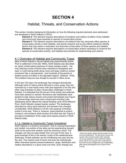
- Page 38 and 39: variability can make identifying sp
- Page 40 and 41: are differences between classificat
- Page 42 and 43: 4.4 The Process for Identifying Thr
- Page 44 and 45: 4.5.a Private Land Nearly 89 percen
- Page 46 and 47: SECTION 5 Landscape Components This
- Page 48 and 49: 5.1 Tallgrass Prairie (Red River Va
- Page 50 and 51: 5.1.c Conservation Problems and Act
- Page 52 and 53: 5.2 Eastern Mixed-grass Prairie (Dr
- Page 54 and 55: 5.2.c Conservation Problems and Act
- Page 56 and 57: 5.3 Mixed-grass Prairie (Missouri C
- Page 58 and 59: 5.3.b Conservation Problems and Act
- Page 60 and 61: 5.4 Western Mixed-grass/Short-grass
- Page 62 and 63: 5.4.b Conservation Problems and Act
- Page 64 and 65: 5.5 Planted or Tame Grassland Area:
- Page 66 and 67: 5.5.b Conservation Problems and Act
- Page 68 and 69: Temporary Seasonal Semipermanent Pe
- Page 70 and 71: 5.6.a Conservation Problems and Act
- Page 72 and 73: 5.7 Rivers, Streams and Riparian To
- Page 74 and 75: 5.7.b Focus Area: Red River Descrip
- Page 76 and 77: of Mandan. The Heart River is threa
- Page 78 and 79: RIVERS, STREAMS AND RIPARIAN CONSER
- Page 80 and 81: Mammals: desert cottontail, mountai
- Page 82 and 83: CONSERVATION PROBLEM Industrial Dev
- Page 84 and 85: 5.9.a Focus Area: Pembina Hills Are
- Page 86 and 87:
5.9.e Conservation Problems and Act
- Page 88 and 89:
5.10 References A Glossary of Terms
- Page 90 and 91:
SECTION 6 Monitoring This section i
- Page 92 and 93:
determined by objective, ability an
- Page 94 and 95:
• Ducks Unlimited - Grassland Los
- Page 96 and 97:
• Natural Heritage Inventory of R
- Page 98:
Waterbirds Currently, waterbirds ar
- Page 101 and 102:
esources has limited the effectiven
- Page 103 and 104:
SECTION 8 Coordination with Federal
- Page 105 and 106:
8.1.f US Department of Agriculture-
- Page 107 and 108:
• January 7, 2004 again met with
- Page 109 and 110:
SECTION 9 Public Participation This
- Page 111 and 112:
Message: Congress Gives Boost to No
- Page 113 and 114:
9.4 Wildlife Values in the West 200
- Page 115:
This page intentionally left blank.
- Page 118 and 119:
Common Name SoCP Level I, II, or II
- Page 120 and 121:
APPENDIX A.1 Bird Species of Conser
- Page 122 and 123:
RESEARCH AND SURVEY EFFORTS Horned
- Page 124 and 125:
American White Pelican Scientific N
- Page 126 and 127:
REFERENCES American White Pelican L
- Page 128 and 129:
American Bittern Level I Other Natu
- Page 130 and 131:
Northern Pintail Scientific Name: A
- Page 132 and 133:
Northern Pintail Level II Previous
- Page 134 and 135:
Canvasback Scientific Name: Aythya
- Page 136 and 137:
Canvasback Level II Sauer, J. R., J
- Page 138 and 139:
RESEARCH AND SURVEY EFFORTS Redhead
- Page 140 and 141:
Northern Harrier Scientific Name: C
- Page 142 and 143:
MONITORING PLANS Northern Harrier L
- Page 144 and 145:
Swainson’s Hawk Level I Other Nat
- Page 146 and 147:
Ferruginous Hawk Scientific Name: B
- Page 148 and 149:
Ferruginous Hawk Level I MANAGEMENT
- Page 150 and 151:
Golden Eagle Scientific Name: Aquil
- Page 152 and 153:
Golden Eagle Level II Additional Re
- Page 154 and 155:
Bald Eagle Scientific Name: Haliaee
- Page 156 and 157:
Bald Eagle Level II Rosenberg, K. V
- Page 158 and 159:
RESEARCH AND SURVEY EFFORTS Peregri
- Page 160 and 161:
RESEARCH AND SURVEY EFFORTS Prairie
- Page 162 and 163:
Sharp-tailed Grouse Scientific Name
- Page 164 and 165:
Sharp-tailed Grouse Level II Manske
- Page 166 and 167:
Greater Prairie Chicken Level II Ot
- Page 168:
Greater Sage-Grouse Scientific Name
- Page 171:
Yellow Rail Scientific Name: Coturn
- Page 174 and 175:
Whooping Crane Scientific Name: Gru
- Page 176 and 177:
Piping Plover Scientific Name: Char
- Page 178 and 179:
Piping Plover Level II Prindiville
- Page 180 and 181:
RESEARCH AND SURVEY EFFORTS America
- Page 182 and 183:
Willet Scientific Name: Cataptropho
- Page 184 and 185:
REFERENCES Willet Level I Brown, S.
- Page 186 and 187:
RESEARCH AND SURVEY EFFORTS Upland
- Page 188 and 189:
Long-billed Curlew Scientific Name:
- Page 190 and 191:
REFERENCES Long-billed Curlew Level
- Page 193 and 194:
Marbled Godwit Level I and provide
- Page 195 and 196:
RESEARCH AND SURVEY EFFORTS Wilson
- Page 197 and 198:
Franklin’s Gull Scientific Name:
- Page 199 and 200:
Least Tern Scientific Name: Sterna
- Page 201 and 202:
Black Tern Scientific Name: Chlidon
- Page 203 and 204:
REFERENCES Black Tern Level I Beyer
- Page 205 and 206:
RESEARCH AND SURVEY EFFORTS Black-b
- Page 207 and 208:
Burrowing Owl Scientific Name: Athe
- Page 209 and 210:
MONITORING PLANS Burrowing Owl Leve
- Page 211 and 212:
RESEARCH AND SURVEY EFFORTS Short-e
- Page 213 and 214:
Red-headed Woodpecker Scientific Na
- Page 215 and 216:
Red-headed Woodpecker Level II Smit
- Page 217 and 218:
RESEARCH AND SURVEY EFFORTS Loggerh
- Page 219 and 220:
Sedge Wren Scientific Name: Cistoth
- Page 221 and 222:
Sedge Wren Level II Grant, T. A., E
- Page 223 and 224:
Sprague’s Pipit Level I Other Nat
- Page 225 and 226:
Brewer’s Sparrow Scientific Name:
- Page 227 and 228:
Brewer’s Sparrow Level III Rosenb
- Page 229 and 230:
RESEARCH AND SURVEY EFFORTS Lark Bu
- Page 231 and 232:
Grasshopper Sparrow Scientific Name
- Page 233 and 234:
REFERENCES Grasshopper Sparrow Leve
- Page 235 and 236:
Baird’s Sparrow Scientific Name:
- Page 237 and 238:
REFERENCES Baird’s Sparrow Level
- Page 239 and 240:
RESEARCH AND SURVEY EFFORTS Le Cont
- Page 241 and 242:
Nelson’s Sharp-tailed Sparrow Sci
- Page 243 and 244:
Nelson’s Sharp-tailed Sparrow Lev
- Page 245 and 246:
RESEARCH AND SURVEY EFFORTS McCown
- Page 247 and 248:
Chestnut-collared Longspur Scientif
- Page 250 and 251:
Dickcissel Scientific Name: Spiza a
- Page 252 and 253:
REFERENCES Dickcissel Level II Dech
- Page 254 and 255:
Bobolink Level II Other Natural or
- Page 256 and 257:
Bobolink Level II Sibley, D. A. 200
- Page 258 and 259:
APPENDIX A.2 Amphibian and Reptile
- Page 260 and 261:
Plains Spadefoot Level I study to r
- Page 262 and 263:
Canadian Toad Scientific Name: Bufo
- Page 264 and 265:
Common Snapping Turtle Scientific N
- Page 266 and 267:
Common Snapping Turtle Level II Rat
- Page 268 and 269:
False Map Turtle Level III • A co
- Page 270 and 271:
Smooth Softshell Level III Previous
- Page 272 and 273:
Northern Sagebrush Lizard Level III
- Page 274 and 275:
Short-horned Lizard Level III Previ
- Page 276 and 277:
Northern Prairie Skink Level III
- Page 278 and 279:
Northern Redbelly Snake Level II
- Page 280 and 281:
Western Hognose Snake Level I Previ
- Page 282 and 283:
Smooth Green Snake Level I • Hobe
- Page 284 and 285:
APPENDIX A.3 Mammal Species of Cons
- Page 286 and 287:
Arctic Shrew Level III • A specie
- Page 288 and 289:
Pygmy Shrew Scientific Name: Sorex
- Page 290 and 291:
Western Small-footed Myotis Scienti
- Page 292 and 293:
Western Small-footed Myotis Level I
- Page 294 and 295:
Long-eared Myotis Level III Indiscr
- Page 296 and 297:
Long-legged Myotis Scientific Name:
- Page 298 and 299:
Long-legged Myotis Level III Swenso
- Page 300 and 301:
Hispid Pocket Mouse Level III Addit
- Page 302 and 303:
Plains Pocket Mouse Scientific Name
- Page 304 and 305:
Plains Pocket Mouse Level III Seabl
- Page 306 and 307:
Sagebrush Vole Level III Additional
- Page 308 and 309:
Black-tailed Prairie Dog Level I
- Page 310 and 311:
Richardson’s Ground Squirrel Scie
- Page 312 and 313:
Richardson’s Ground Squirrel Leve
- Page 314 and 315:
Gray Wolf Level III traveling long
- Page 316 and 317:
Swift Fox Scientific Name: Vulpes v
- Page 318 and 319:
Swift Fox Level II Seabloom, R. W.,
- Page 320 and 321:
PROBLEMS WHICH MAY AFFECT THIS SPEC
- Page 322 and 323:
Black-footed Ferret Scientific Name
- Page 324 and 325:
Black-footed Ferret Level I Wilson,
- Page 326 and 327:
Eastern Spotted Skunk Level III Add
- Page 328 and 329:
This page intentionally left blank.
- Page 330 and 331:
Chestnut Lamprey Scientific Name: I
- Page 332 and 333:
Chestnut Lamprey Level III • The
- Page 334 and 335:
Silver Lamprey Level III • Survey
- Page 336 and 337:
Pallid Sturgeon Scientific Name: Sc
- Page 338 and 339:
Pallid Sturgeon Level II MONITORING
- Page 340 and 341:
RESEARCH AND SURVEY EFFORTS Paddlef
- Page 342 and 343:
Central Stoneroller Scientific Name
- Page 344 and 345:
Central Stoneroller Level III Power
- Page 346 and 347:
Sturgeon Chub Level I Other Natural
- Page 348 and 349:
Sicklefin Chub Scientific Name: Mac
- Page 350 and 351:
Sicklefin Chub Level I MONITORING P
- Page 352 and 353:
Silver Chub Level II • In the lat
- Page 354 and 355:
Pearl Dace Scientific Name: Margari
- Page 356 and 357:
Pearl Dace Level I MONITORING PLANS
- Page 358 and 359:
Hornyhead Chub Level III • Invest
- Page 360 and 361:
Pugnose Shiner Scientific Name: Not
- Page 362 and 363:
Pugnose Shiner Level III MONITORING
- Page 364 and 365:
Blacknose Shiner Level III • Inve
- Page 366 and 367:
Rosyface Shiner Scientific Name: Hy
- Page 368 and 369:
Rosyface Shiner Level III • The N
- Page 370 and 371:
Northern Redbelly Dace Level II Pre
- Page 372 and 373:
Finescale Dace Scientific Name: Pho
- Page 374 and 375:
Finescale Dace Level III • The ND
- Page 376 and 377:
RESEARCH AND SURVEY EFFORTS Flathea
- Page 378 and 379:
Blue Sucker Scientific Name: Cyclep
- Page 380 and 381:
Blue Sucker Level I Page, L.M., and
- Page 382 and 383:
Yellow Bullhead Level III • In th
- Page 384 and 385:
Flathead Catfish Scientific Name: P
- Page 386 and 387:
Trout-perch Scientific Name: Percop
- Page 388 and 389:
Trout-perch Level II MONITORING PLA
- Page 390 and 391:
Logperch Level III • In the late
- Page 392 and 393:
River Darter Scientific Name: Perci
- Page 394 and 395:
River Darter Level III • The Nort
- Page 396 and 397:
APPENDIX A.5 Freshwater Mussel Spec
- Page 398 and 399:
Threeridge Level II • The North D
- Page 400 and 401:
Wabash Pigtoe Level II Previous Res
- Page 402:
Mapleleaf Level II Previous Researc
- Page 405 and 406:
Creek Heelsplitter Scientific Name:
- Page 407 and 408:
Pink Heelsplitter Scientific Name:
- Page 409 and 410:
Pink Papershell Scientific Name: Po
- Page 411 and 412:
This page intentionally left blank.
- Page 413 and 414:
411
- Page 415 and 416:
413
- Page 417 and 418:
415
- Page 419 and 420:
417
- Page 421 and 422:
419
- Page 423 and 424:
APPENDIX C Focus Areas Map The foll
- Page 425 and 426:
This page intentionally left blank.
- Page 427 and 428:
425
- Page 429 and 430:
427
- Page 431 and 432:
This page intentionally left blank.
- Page 433 and 434:
Ideal Breeding/Habitat Conditions a
- Page 435 and 436:
BIRDS Ideal Breeding/Habitat Condit
- Page 437 and 438:
BIRDS Ideal Breeding/Habitat Condit
- Page 439 and 440:
BIRDS Ideal Breeding/Habitat Condit
- Page 441 and 442:
Ideal Breeding/Habitat Conditions f
- Page 443 and 444:
Glossary/Definitions Terrestrial De
- Page 445 and 446:
(F) Semipermanently Flooded. Surfac
- Page 447 and 448:
This page intentionally left blank.
- Page 449 and 450:
A Abiotic. Non-living. Climate is a
- Page 451 and 452:
Feral. Escaped from cultivation or
- Page 453 and 454:
Overgrazed Range. A range which has
- Page 455 and 456:
etween trees and shrubs. Some plant


