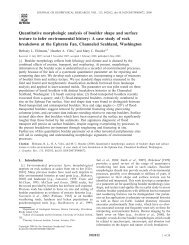
392 HARMON ET AL.' RADAR ALTIMETRY OF MERCURYhas an asymmetric rim structure which is probably influencedstrongly by the underlying large-scale topography. There is,however, a distinct break in slope in the radar pr<strong>of</strong>iles southand east <strong>of</strong> Mozart (see Figure 6) which correlates well withthe edge <strong>of</strong> Mozart's continuous ejecta blanket as mapped by$chaber and McCauley [1980]. Here the radar pr<strong>of</strong>iles indicatea thickness <strong>of</strong> about 1 km for the rim/ejecta deposits at adistance <strong>of</strong> 1.2 crater radii from the rim crest.Interior structure can be discerned for some <strong>of</strong> the largercraters and basins. For example, the craters Asvaghosa andYeats both show hints <strong>of</strong> central peak topography (Figure 2a).One <strong>of</strong> the pr<strong>of</strong>iles across Mozart (Figures 2c and 6) showssome interior structure which may be indicative <strong>of</strong> an innerring, the existence <strong>of</strong> which is also hinted at by the USGS H-8shaded-relief map. Mozart appears to have a somewhat bowl-shaped floor (Figures 2c and 6, uppermost pr<strong>of</strong>ile), in contrastto the usual assumption that larger craters and basins areflat-floored structures. The large crater in the unimaged hemisphereat 279øW, 8.5øN (Figure 2d), though comparable in sizeto Mozart, shows shallower walls broken by terrace featuresthis is a result <strong>of</strong>' either a lower basin production rate or ahigher degree <strong>of</strong> isostatic relaxation than has operated on themoon. Others have discussed the lack <strong>of</strong> identifiable multiringstructures on <strong>Mercury</strong> compared to the moon or Mars andhave emphasized the role that crustal characteristics may haveplayed in the formation <strong>of</strong> very large impact structures on theterrestrial planets [Wood and Head, 1976; Strom, 1979]. Morerecently, Spudis and Strobell [1984] claim to have identified anumber <strong>of</strong> degraded multiring structures based on carefulphotogeologic mapping <strong>of</strong> massifs and massif chains, arcuatesegments <strong>of</strong> ridges and scarps, rejuvenated crater rims, andregions <strong>of</strong> anomalously high topography. Topographic informationprovided by radar allows us to examine and evaluatethree large impact structures discussed in these works.The one large basin identified in both the Schaber et al.[1977] and Spudis and Strobell [1984] surveys for which wehave extensive radar coverage is that which is bisected by theequator in the western portion <strong>of</strong> the H-7 quadrangle. Schaberet al. [1977] list it as an 839-km-diameter, single-rimmedbasin centered on 130øW, 1.8øN. It is the second largest Mercurianbasin in their survey after Caloris. Spudis and Strobell[1984] identify this same basin (which they name "Mena-Theophanes") as a multiring structure centered on 129øW, IøS,with concentric rings <strong>of</strong> diameters 260, 475, 770, and 1200 km.In Figure 5 we show four <strong>of</strong> the altitude pr<strong>of</strong>iles across thebasin on an expanded scale (see also Figure 2b) along withmarkers indicating the approximate basin edges as given bythe USGS shaded-relief map and Schaber et al. [1977]. Thesuggestive <strong>of</strong> an inner ring. This structure is likely to be apeak-ring basin <strong>of</strong> the same class as the basins Renoir andRodin.The peak-ring structure within Homer Basin (Figure 4)shows up only as rather subdued breaks in slope on the easternside <strong>of</strong> the basin and as a 600-m-high interior peak in thetopography on the western side. Homer shares its western rimwith a larger, older basin to the west. This unnamed basin iscentered at 44øW, 2.1øS and was included along with Mozartand Homer in a survey <strong>of</strong> large craters and basins by Schaberet al. [1977]. Superposition <strong>of</strong> ejecta from Homer as well as itshighly degraded appearance imply that this basin is quite old.The basin is 2.2 km deep at its lowest elevation (measuredpr<strong>of</strong>iles show that the topography across this basin is complexand strongly latitude-dependent. The basin floor has been significantlyaltered by postbasin impacts; several have left cratersmore than 70 km in diameter. Other portions <strong>of</strong> the basinfloor appear topographically smooth, possibly indicating afrom the rim crest). This is shallower than the 2.8 km depth smooth plains fill. The southernmost pr<strong>of</strong>ile at 4.5øS is themeasured for Homer, although it is likely that the apparent simplest <strong>of</strong> the four pr<strong>of</strong>iles in Figure 5. It shows 1.2 km <strong>of</strong>rather smooth, down-bowed relief, an upraised rim in the east,depth <strong>of</strong> Homer is enhanced by the fact that it lies astride aand a western rim which corresponds to a scarp visible inregional west-facing downslope. Unlike Homer, the basin atMariner 10 imagery. Another pr<strong>of</strong>ile at 2øS (Figure 2b; pr<strong>of</strong>ile44øW shows no obvious topographic or morphological ring.not shown in Figure 5) shows a rise-up from the basin floorIn addition to the superposition <strong>of</strong> ejecta from Homer, theinterior <strong>of</strong> this basin has been modified by the impact thatjust north <strong>of</strong> Theophanes Crater which could correspond t<strong>of</strong>ormed Titian Crater (see Figure 4) and by extensive smooth the outer basin ring <strong>of</strong> Spudis and Strobell [1984]. The mostplains formation [De Honet al., 1981]. <strong>Radar</strong> pr<strong>of</strong>iles place northerly pr<strong>of</strong>ile in Figure 5 shows a very prominent basinthe topographic rim <strong>of</strong> the unnamed basin near the narrow rim in the NW along with two smooth, down-bowed sectionstrough which De Hon et al. [1981] map as a crater chain. The <strong>of</strong> basin floor in the NW and NE. The two northern pr<strong>of</strong>iles intopographic rise from the basin floor begins well to the east <strong>of</strong> Figure 5 show very little topographic expression across thethis feature, however, and the trough itself is apparently tooshallow or too narrow to yield an identifiable radar signature.There are several cases where crater pr<strong>of</strong>iles are influencedor distorted by underlying topography. For example, theNE rim <strong>of</strong> the basin, whereas the eastern portion <strong>of</strong> the thirdpr<strong>of</strong>ile (that nearest the equator) does show some structurewhich may be basin-related. The radar data show that, overall,the interior <strong>of</strong> the basin is not significantly lower than theprominent rim <strong>of</strong> the crater ^svaghosa (Figure 2a and 10) is level <strong>of</strong> the adjacent terrain. This suggests that the basin hasbeen severely modified by postimpact processes such as isoprobablyaccentuated by the fact that it was excavated from astatic relaxation, impact cratering, and volcanic filling. In adtopographicallyhigh region formed by the combined ejecta <strong>of</strong>dition, the interior <strong>of</strong> the basin may have experienced someseveral large impact craters [De Hon et al., 1981] and lieslocalized subsidence due to the emplacement <strong>of</strong> smooth plains.adjacent to two topographically lower plains regions to theeast and west. Craters Handel and Yeats and Homer Basin are Although there are some apparent correspondences betweentilted, apparently due to a significant west-facing regionaltopography and the locations <strong>of</strong> concentric basin rings identislope(see section 6), as are the craters Rudaki and Zeami fied by Spudis and Strobell [1984], the radar data do not <strong>of</strong>fer(Figures 2a and 2c). In addition, the interior <strong>of</strong> the crater unambiguous support for the argument that this basin is aYeats displays a topographic high that may be the signature multiring structure.<strong>of</strong> an intracrater scarp, although there may also be a contributionfrom the central peak.Two other basins identified by Spudis and Strobell [1984]are also covered by altimetry pr<strong>of</strong>iles. The first <strong>of</strong> these is afour-ring, 1250-km-diameter structure centered on 168øW,Large BasinsThe apparent dearth <strong>of</strong> large impact structures (diametergreater than 400 km) on <strong>Mercury</strong> relative to lunar abundances6øN; the second is a five-ring, 1500-km-diameter structurecentered on 4øW, 10øN [Spudis and Strobe!l, 1984]. In neithercase do we find any long-wavelength topographic signature inhas been discussed by Schaber et al. [1977]. They suggesthat the radar data indicative <strong>of</strong> a basin. While some smaller-scale
HARMON ET AL..' RADAR ALTIMETRY OF MERCURY 393It I I It0.7-4.5 _150i 1140 130 t20 I0Longitude (øw)Fig. 5. Altitude pr<strong>of</strong>iles selected from the H-7 quadrangle (see Figure 2b) showing topography across the large basincentered at 130øW, 1.8øN [Schaber et al., 1977]. Vertical bars indicate the q- 1 standard deviation altitude errors. Bracketsdenote the approximate locations <strong>of</strong> the basin rim as given by the USGS shaded-relief map and Schaber et al. [1977]. Seetext for discussion. The subradar tracks for these pr<strong>of</strong>iles are shown on the USGS shaded-relief map at the top.features in the altimetry may correspond to remnant ring provide strong evidence for a large expanse <strong>of</strong> downwarpedstructures associated with these basins, no such identifications smooth plains extending well into the unimaged hemisphere;could be made unambiguously. We stress, however, that our this may, in fact, be part <strong>of</strong> an irregular annulus <strong>of</strong> smoothradar data, with its limited coverage and resolution, is inferior plains entirely surrounding Caloris Basin (see section 5). Theto images for the identification <strong>of</strong> remnant ring structures as- radar data also show that the region south <strong>of</strong> Caloris is one <strong>of</strong>sociated with highly degraded basins.the highest regions in the equatorial zone <strong>of</strong> <strong>Mercury</strong> in termsThe largest prominent impact structure on <strong>Mercury</strong> is Ca- <strong>of</strong> absolute altitude (see section 7). The photoclinometry relorisBasin. The southern edge <strong>of</strong> the basin (Caloris Montes) sults <strong>of</strong> Hapke et al. [1975] suggest that the center <strong>of</strong> Calorisextends down to 14øN latitude, 5 ø north <strong>of</strong> the nearest subra- is at least 7 km below the eastern edge <strong>of</strong> the basin. Thus it isdar track. Although the Arecibo pr<strong>of</strong>iles do not cross the likely that the inner edge <strong>of</strong> the smooth plains annulus isbasin proper, the pr<strong>of</strong>iles in the southern environs <strong>of</strong> Caloris higher than the center <strong>of</strong> Caloris. Clearly, the distinctive radarare very distinctive and probably reflect topographic structure signature <strong>of</strong> a basin like Caloris would be easily recognized ifrelated to the event that formed Caloris and to postimpact such a basin lay within roughly 45 ø <strong>of</strong> the equator in theprocesses. <strong>Radar</strong> pr<strong>of</strong>iles in this region (see Figures 2c and 6) unimaged portion <strong>of</strong> the planet.