Radar Altimetry of Mercury: A Preliminary Analysis - Brown ...
Radar Altimetry of Mercury: A Preliminary Analysis - Brown ...
Radar Altimetry of Mercury: A Preliminary Analysis - Brown ...

Create successful ePaper yourself
Turn your PDF publications into a flip-book with our unique Google optimized e-Paper software.
JOURNAL OF GEOPHYSICAL RESEARCH, VOL. 91, NO. B1, PAGES 385-401, JANUARY 10, 1986<strong>Radar</strong> <strong>Altimetry</strong> <strong>of</strong> <strong>Mercury</strong>' A <strong>Preliminary</strong> <strong>Analysis</strong>J. K. HARMON AND D. B. CAMPBELLNational Astronomy and Ionosphere Center, Arecibo, Puerto RicoD. L. BINDSCHADLER AND J. W. HEADDepartment <strong>of</strong> Geological Sciences, <strong>Brown</strong> University, Providence, Rhode IslandI. I. SHAPIROHarvard-Smithsonian Center for Astrophysics, Cambridge, MassachusettsMeasurements <strong>of</strong> Mercurian topography based on Arecibo radar observations are presented. The data,which were obtained from 1978 to 1984, cover much <strong>of</strong> the equatorial zone <strong>of</strong> <strong>Mercury</strong> between 12øNand 5øS latitude. Over thirty continuous altitude pr<strong>of</strong>iles were obtained, each spanning from 20 to 90degrees <strong>of</strong> longitude at a resolution <strong>of</strong> 0.15 ø (longitude) by 2.5 ø (latitude). <strong>Radar</strong> depths for large craterssupport previous indications from imagery that Mercurian craters are shallower than lunar craters <strong>of</strong> thesame size. One very large (800 km) impact basin shows some distinct topographic structure, although itsrelative shallownes suggests postimpact modification by isostatic relaxation or volcanic filling. Theplains <strong>of</strong> Tir Planitia appear topographically smooth to the radar. These plains extend well into thehemisphere not imaged by Mariner 10, possibly forming part <strong>of</strong> a large annulus <strong>of</strong> smooth plains aroundCaloris Basin. The circum-Caloris smooth plains are strongly down-bowed, indicating subsidence undera load. This and other similarities to lunar maria suggest a volcanic origin for these plains. Additionalareas <strong>of</strong> topographically smooth terrain have been found in both the imaged and unimaged hemispheres.Several ridges, scarps, and fault zones have been identified in the altimetry. Three mapped arcuate scarpsshow heights <strong>of</strong> about 700 m and cross-sectional widths <strong>of</strong> about 70 km. One <strong>of</strong> these features is clearly aridge, while the other two scarps have a more ridge-like appearance than is suggested by images. Onelarge-scale topographic drop <strong>of</strong> 3 km correlates well with a mapped system <strong>of</strong> faults and intracraterscarps. The equatorial zone <strong>of</strong> <strong>Mercury</strong> shows 7 km <strong>of</strong> maximum relief, although the typical elevationdifference between highlands and lowlands is closer to 3 km. Three major highland areas are found, thelargest two <strong>of</strong> which are roughly antipodal and aligned within about 10 ø <strong>of</strong> the "hot poles" <strong>of</strong> <strong>Mercury</strong>.The unimaged hemisphere, possessing both large craters and topographically smooth areas, does notappear to be markedly different in its topography from the imaged hemisphere. No evidence has beenfound for another Caloris-type impact structure in the unimaged hemisphere.1. INTRODUCTIONA program <strong>of</strong> 2380 MHz radar observations <strong>of</strong> <strong>Mercury</strong> hasbeen conducted at Arecibo Observatory since 1978. These observationshave yielded an extensive set <strong>of</strong> altitude measurementsover the equatorial zone <strong>of</strong> the planet. In this paper wepresent the altimetry results and discuss some <strong>of</strong> the possibleimplications for Mercurian geology.The earliest information on Mercurian topography was providedby radar-ranging observations [Smith et al., 1970;Ingalls and Rainville, 1972]. These measurements showed thatthe range <strong>of</strong> altitudes on <strong>Mercury</strong> was somewhat less than hadbeen measured for the equatorial zones <strong>of</strong> Venus and Mars.The most detailed <strong>of</strong> the <strong>Mercury</strong> radar measurements, andthe last to be published, were by Zohar and Goldstein [1974].Their data showed "hills and valleys" with 1-2 km relief andprovided the first evidence <strong>of</strong> craters.With the Mariner 10 spacecraft encounters <strong>of</strong> 1974-1975came the first detailed look at the surface <strong>of</strong> <strong>Mercury</strong>. TheMariner 10 photographic images, which covered 45% <strong>of</strong> theplanet at 0.1-4 km resolution, revealed a heavily cratered,lunar-like surface [Murray et al., 1974; Trask and Guest,1975]. The images suggested tectonics dominated by compressiveforces as manifested in the unique Mercurian scarpsystem. While these results were consistent with the relativelyCopyright 1986 by the American Geophysical Union.Paper number 5B5488.0148-0227/86/005 B- 5488 $05.00385subdued topography measured by earth-based radar, Mariner10 carried no altimeter and quantitative altimetry was limitedto shadow measurements <strong>of</strong> high-relief features such as cratersand scarps [Gault et al., 1975; Strom et al., 1975] and a fewphotoclinometry results [e.g., Hapke et al., 1975]. In addition,many <strong>of</strong> the Mariner 10 images were obtained at unfavorableillumination angles and one entire hemisphere (the dark sideat the times <strong>of</strong> encounter) was not imaged at all.It was clear, then, that useful earth-based radar work on<strong>Mercury</strong> remained to be done and a regular program <strong>of</strong> radarrangingobservations <strong>of</strong> the planet was undertaken at Arecibo.In the following section we present a brief discussion <strong>of</strong> theobservations and the data reduction to altitude pr<strong>of</strong>iles. Thisdiscussion is followed by a display <strong>of</strong> the altitude pr<strong>of</strong>iles irl aform which is intended to be convenient for the reader wishingto make comparisons with the U.S. Geological Survey shadedreliefand geologic maps and the Mariner 10 images. In thelatter half <strong>of</strong> the paper we point out some <strong>of</strong> the more interest-ing features <strong>of</strong> the Arecibo altimetry, and discuss them in thecontext <strong>of</strong> the geological interpretations which have accumulatedin the decade since the Mariner 10 encounters.2. DATA ACQUISITION AND REDUCTIONObservations and Planet CoverageThe observations were made with the 2380 MHz (12.6 cmwavelength) radar on the 305-m-diameter telescope at the AreciboObservatory in Puerto Rico. The specifications <strong>of</strong> the
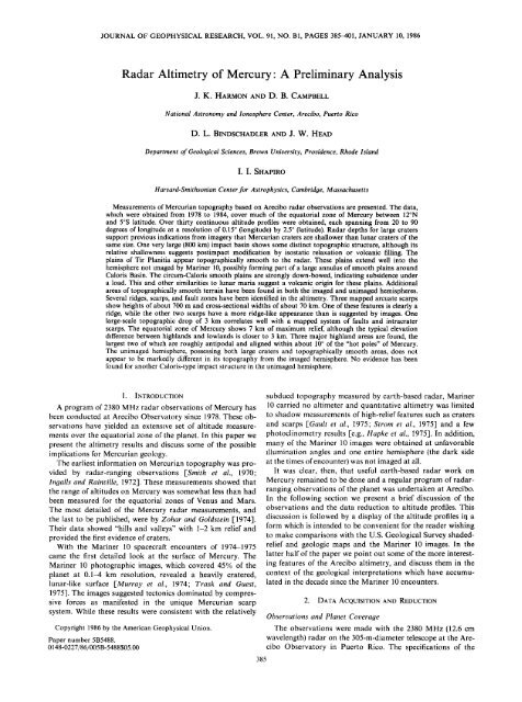
386 HARMON ET AL.' RADAR ALTIMETRY OF MERCURYTABLE 1. <strong>Radar</strong> System CharacteristicsTABLE 2. Locations <strong>of</strong> <strong>Mercury</strong> <strong>Radar</strong> Pr<strong>of</strong>iles' 1978-1984ParameterValue or TypeNumber Longitude LatitudeFrequencyTransmit powerAntenna gainSystem temperatureTransmit waveformPolarizationSampling intervalFrequency resolutionIntegration time2380 MHz (12.6 cm wavelength)400 kW71 dB35ø-90øKphase-coded CW (4/•s baud-length)right circular (transmit)left circular (receive)20.061 or 0.122 Hz10-20 minobserving system and some relevant observational parametersare listed in Table 1. The measurements were made in theso-called "delay-Doppler" mode. Delay (altitude) discriminationwas achieved by phase-coding the transmitted signal,and Doppler (longitude) discrimination was obtained fromFourier analysis <strong>of</strong> the coherently detected echo. The delay-Doppler data were analyzed in such a way as to yield a pr<strong>of</strong>ile<strong>of</strong> altitude along the subradar track.<strong>Mercury</strong>'s 7 ø orbital inclination to the ecliptic renders a_+ 12 ø equatorial band accessible to earth-based radar altimetry.Achieving extensive coverage over even this very restrictedlatitude band requires making observationsa largenumber <strong>of</strong> orbital aspects which, in turn, requires that observationsbe spread out over several years. The data presentedin this paper were derived from approximately 150 days <strong>of</strong>observations spread over the six-year period 1978-1984. Thelocation tracks <strong>of</strong> the Arecibo altitude pr<strong>of</strong>iles on <strong>Mercury</strong>'ssurface are mapped in Figure 1.1 4ø-27øW 10.7ø-9.9øN2 5ø-42øW 3.8ø-4.1 øN3 6ø-54øW 2.0ø-3.2øN4 21ø-61øW 0.5øS-0.4øN5 24ø-69øW 10.3ø-8.3øN6 26ø-56øW 1.8ø-1.4øS7 37ø-69øW 9.4ø-7.7øN8 43 ø-71 øw 5.0ø-4.3 øS9 66ø-85øW 3.5ø-4.1 øN10 71ø-97øW 7.2ø-6.5øN11 97ø-129øW 6.5ø-5.7øN12 104ø-126øW 5.5ø-5.3øN13 106ø-120 øw 6.00-5.3 ON14 109ø-138øW 3.6ø-4.8øN15 112ø-148øW 5.1ø-6.5øN16 113ø-141 øW 0.1 øS-0.7øN17 122ø-140øW 4.5ø-4.5øS18 127ø-169øW 5.9ø-5.3øN19 137ø-224øW 2.0øS-0.2øN20 150ø-197øW 5.3ø-7.4øN21 158ø-241øW 6.9ø-10.3øN22 174ø-209øW 4.4ø-5.9øN23 182ø-218øW 2.0ø-3.4øN24 216ø-259øW 4.3ø-5.3øN25 246ø-269øW 0.7ø-0.1 øS26 261 ø-330øW 7.9ø-8.9øN27 261ø-291øW 5.7ø-6.2øN28 279ø-338øW 10.4ø-10.8øN29 283ø-308øW 2.1ø-2.7øN30 287ø-309øW 0.3ø-0.8øN31 291ø-319øW 11.6ø-11.8øN32 320ø-339øW 1.0ø-l.3øN33 328ø-360øW 0.1ø-l.2øN34 338ø-359øW 11.4ø-10.9øNAltitudeMeasurementsThe first step in the data analysis was to produce an alti- templates were then fit to the run-averaged delay-Dopplertude pr<strong>of</strong>ile for each observing "run." One to three observing array to determine the time delay to the leading edge <strong>of</strong> theruns were made on a given day; a run consisted <strong>of</strong> a transmit planet at each Doppler frequency. From these delays wereand a receive period, each equal in duration to the round-trip subtracted the computed time delays to a reference sphere <strong>of</strong>light-travel time (10-20 min). The decoded echo was Fourier radius 2439 km. The resultant residual delays were then exanalyzedto yield a delay-Doppler array for each 8.4 or 16.8 s pressed as altitudes relative to the reference sphere. Using thecoherence interval, giving a frequency resolution <strong>of</strong> 0.06 or Doppler frequencies to provide an effective longitude discrimi-0.12 Hz or, equivalently, longitude resolutions <strong>of</strong> about 0.07 ø- nation, the final result for each run was an altitude pr<strong>of</strong>ile0.15 ø . These arrays were then summed incoherently over the along a roughly east-west linear track extending approxifullreceive period to give a single delay-Doppler array for mately 7 ø <strong>of</strong> longitude to either side <strong>of</strong> the subradar point.each run. Numerically computed echo power-versus-delay This is the same analysis technique used by Ingalls and Rainville[1972] and Shapiro et al. [1972], and the reader is referredto these papers for a more detailed explanation.By making several runs on the same day and observing oncontiguous days (<strong>Mercury</strong> rotates by about 5 ø per day), weachieved extensive overlap among the individual pr<strong>of</strong>iles. The8final step in the analysis consisted <strong>of</strong> collating overlappingpr<strong>of</strong>iles and averaging them over 0.15 ø longitude bins to pro-4duce a single "composite" pr<strong>of</strong>ile. Each composite pr<strong>of</strong>ilespans from 20 ø to 90 ø <strong>of</strong> longitude and consists <strong>of</strong> data taken0 •from as many as 11 days <strong>of</strong> observing. A list <strong>of</strong> the composite<strong>Mercury</strong> pr<strong>of</strong>iles from 1978-1984 is given in Table 2.The surface resolution ("radar footprint") <strong>of</strong> the altitudemeasurements is approximately 0.15 ø x 2.5 ø (6.4 x 10⁶ km).560 270 ' ' ' 180 ' ' ' 9'0 ' ' 0The 0.15 ø longitude bin size is roughly equal to the coarsestresolution <strong>of</strong> the individual pr<strong>of</strong>iles and is larger than theLongitude (øw)maximum longitude smear from planet rotation over an ob-Fig. 1. Location tracks on <strong>Mercury</strong> for the Arecibo radar alti- serving run. The latitude resolution is much coarser, as eachmetry pr<strong>of</strong>iles (1978-1984). The radar resolution cell actually extendsover 2.5 ø <strong>of</strong> latitude centered on the indicated track (see text). Note altitude data point can be influenced by echoes arising fromthat the latitude scale is exaggerated; the Arecibo coverage is confined anywhere within roughly a degree to the north or south <strong>of</strong> theto a near-equatorial band.subradar track. Interpretation problems resulting from scat-
_390 HARMON ET AL.' RADAR ALTIMETRY OF MERCURYi i i• I 10.4_5.7 5.5I I I9.310.3 •••280 270 260 250 240 230 220,Longitude (øw)0.2•'•Fig. 2d. Altitude pr<strong>of</strong>iles for the H-9 quadrangle (216ø-288øWlongitude). The display format follows that <strong>of</strong> Figure 2a (see caption).This entire quadrangle lies in the unimaged hemisphere.crater rim heights if the rim crest fills only a small fraction <strong>of</strong>the area <strong>of</strong> the radar resolution cell. There may also be acorresponding tendency to underestimate crater floor depths,although the intrinsically high radar cross sections <strong>of</strong> craterfloors should mitigate this effect. Finally, a bias can be introducedif the crater floor is <strong>of</strong>fset to the north or south <strong>of</strong> thesubradar track, in which case the measure depth will includea contribution from the planet's spherical figure. This biasamounts to 0.37 km for a 1 ø latitude <strong>of</strong>fset, and increases asthe square <strong>of</strong> the <strong>of</strong>fset. The most striking example <strong>of</strong> thiseffect is the anomalous 6 km drop seen at 143øW, 1.8øS(Figure 2b). This is apparently a signature <strong>of</strong> the crater Theophanes,which lies 2.5 ø south <strong>of</strong> the nominal subradar track.This is an extreme case, however, and in most cases we wouldexpect the upward depth bias due to planet curvature to beabout 10% or less. We have elected not to correct for thecurvature bias because <strong>of</strong> (1) the potential errors in subradarlatitude associated with uncertainties in the true pole position,and (2) the likelihood that this bias will be <strong>of</strong>fset to someextent by underestimation <strong>of</strong> the rim height.In Table 3 are listed the radar-derived depth estimates for23 craters ranging from 40 to 260 km in diameter. Only cratersin the imaged hemisphere <strong>of</strong> <strong>Mercury</strong> are included.4.5NameMozartHandelChaikovskijLysippusZeamiRudakiThakurTyagarajaYeatsLu HsunAsvaghosaTABLE 3. <strong>Mercury</strong> Crater Depth EstimatesDiameter, Depth,Position km km Class190.6øW, 8.0øN 260 2.9 134.0øW, 3.9øN 155 3.1 150.5øW, 8.0øN 145 2.4 2133.0øW, 1.3øN 130 1.8 2147.6øW, 2.5øS 123 2.4 154.5øW, 3.5øS 115 1.8 263.8øW, 2.7øS 105 2.3 2148.9øW, 4.3øN 104 4.1 134.9øW, 9.7øN 100 2.0 182.1øW, 7.3øN 100 1.4 159.9øW, 3.5øS 99 2.5 224.0øW, 0.1 oS 98 3.1 121.2øW, 10.7øN 86 2.0 1129.9øW, 0.1øN 75 2.1 1132.8øW, 6.3øN 72 1.8 255.8øW, 3.7øS 65 2.7 1121.9øW, 5.4øN 58 1.8 2117.8øW, 6.0øN 55 1.8 1119.0øW, 0.2øN 51 2.0 2132.7øW, 4.0øN 50 2.5 2115.7øW, 5.2øN 48 1.8 2110.5øW, 5.5øN 41 1.2 2113.5øW, 6.5øN 40 1.9 2Degradational states for these craters were obtained from thegeologic maps <strong>of</strong> the H-6 and H-8 quadrangles •Schaber andMcCauley, 1980; De Honet al., 1981] and were estimated forthe H-7 quadrangle from Mariner 10 images and the USGSshaded-relief map <strong>of</strong> the quadrangle. Following the treatment<strong>of</strong> Malin and Dzurisin F1977], we have grouped the cratersinto "fresh" or class 1 (USGS classes C3-C5) and "degraded"or class 2 (USGS classes C•-C2) and have plotted their depthsas a function <strong>of</strong> diameter (Figure 3). Included in Figure 3 arethe Mariner 10 shadow-derivedepth data <strong>of</strong> Malin and Dzurisin[1977]; their power-law relation for fresh Mercurian cratersis plotted along with an envelope encompassing theirrange <strong>of</strong> values for both fresh and degraded craters. Alsoshown in Figure 3 is the power-law depth/diameter relation10.95608.9 h,. • FI•O9 1.5 • •,1.0I I I I550 540 530 520Longitude (øw)310 300 290Fig. 2e. Altitude pr<strong>of</strong>iles for the H-10 quadrangle (288ø-360øWlongitude). The display format follows that <strong>of</strong> Figure 2a (see caption).This entire quadrangle lies in the unimaged hemisphere.Diameter (km)i i • i !Fig. 3. Depth versus diameter for fresh class 1 (triangles) and degradedclass 2 (crosses) Mercurian craters as measured by radar altimetry(Table 3). The dotted line shows the approximate range <strong>of</strong>shadow-derivedepth values for fresh and degraded Mercurian cratersl,Malin and Dzurisin, 1977]. The straight lines are the fittedpower-law c•epth/diameterelations for fresh craters on the moonl,Pike, 1974] and <strong>Mercury</strong> rMalin and Dzurisin, 1977].iooo
::HARMON ET AL.: RADAR ALTIMETRY OF MERCURY391..•-•'EL)1" ' Basin •'• .................... :,:.Homer:'.o 4 /' --....-4..--•.- - '' 'ß E]ecta1-,5045 40 35 30 25:i Longitude (øw)Fig. 4. Altitude pr<strong>of</strong>iles selected from the H-6 quadrangle (see Figure 2a) showing topography across Homer Basinand an unnamed basin to the west. Vertical bars indicate the + 1 standard deviation altitude errors. Broken lines indicatethe approximate locations <strong>of</strong> the basin rims as discerned from Mariner 10 images and USGS maps. Arrows denote theapproximate locations <strong>of</strong> the inner (I) and outer (O) basin rings <strong>of</strong> Homer. The location <strong>of</strong> the rim/ejecta from TitianCrater in the floor <strong>of</strong> the western basin is shown. The subradar tracks for these pr<strong>of</strong>iles are shown on the USGSshaded-relief map at the top.for fresh lunar craters [Pike, 1974]. The radar-derived depthsfall well within the range <strong>of</strong> depths found by Malin and Dzurisin[1977], although our average depth for fresh craters is 17%less than their 2.9 km depth for 100-km-diameter fresh craters.Unfortunately, the two sets <strong>of</strong> depth estimates (radar andshadow) are disjoint; no craters were measured by both methodsand thus it is impossible to establish reliably whetherthere is a systematic disagreement between the two techniques.It is clear, however, that most <strong>of</strong> the radar depths <strong>of</strong> freshMercurian craters are significantly lower than the 4.2 kmdepth typical <strong>of</strong> 100-km-diameter fresh lunar craters, whichlends support to the assertion that large craters on <strong>Mercury</strong>are shallower than their lunar counterparts.<strong>Radar</strong> pr<strong>of</strong>iles in the unimaged hemisphere <strong>of</strong> <strong>Mercury</strong>(Figures 2d, 2e) show several features that are obviously <strong>of</strong>impactorigin. Examples include structures at 306øW, 11.7øNand at 355øW, 11.0øN, as well as a possible peak-ring basinlocated at 279øW, 8.3øN. The depths <strong>of</strong> these craters are in the2-3 km range, which is consistent with the depths <strong>of</strong> craters inthe imaged hemisphere.Craterand Basin StructureDespite the subduing effect <strong>of</strong> the finite radar resolution cell,most <strong>of</strong> the crater pr<strong>of</strong>iles exhibit some evidence <strong>of</strong> upraisedrims. Rim heights <strong>of</strong> 0.5-1.0 km are typical, while the freshcraters Tyagaraja and Zeami display asymmetric rims risingas much as 1.5 km above the surrounding terrain (see Figure2c). Mozart, the largest fresh crater within our radar coverage,
392 HARMON ET AL.' RADAR ALTIMETRY OF MERCURYhas an asymmetric rim structure which is probably influencedstrongly by the underlying large-scale topography. There is,however, a distinct break in slope in the radar pr<strong>of</strong>iles southand east <strong>of</strong> Mozart (see Figure 6) which correlates well withthe edge <strong>of</strong> Mozart's continuous ejecta blanket as mapped by$chaber and McCauley [1980]. Here the radar pr<strong>of</strong>iles indicatea thickness <strong>of</strong> about 1 km for the rim/ejecta deposits at adistance <strong>of</strong> 1.2 crater radii from the rim crest.Interior structure can be discerned for some <strong>of</strong> the largercraters and basins. For example, the craters Asvaghosa andYeats both show hints <strong>of</strong> central peak topography (Figure 2a).One <strong>of</strong> the pr<strong>of</strong>iles across Mozart (Figures 2c and 6) showssome interior structure which may be indicative <strong>of</strong> an innerring, the existence <strong>of</strong> which is also hinted at by the USGS H-8shaded-relief map. Mozart appears to have a somewhat bowl-shaped floor (Figures 2c and 6, uppermost pr<strong>of</strong>ile), in contrastto the usual assumption that larger craters and basins areflat-floored structures. The large crater in the unimaged hemisphereat 279øW, 8.5øN (Figure 2d), though comparable in sizeto Mozart, shows shallower walls broken by terrace featuresthis is a result <strong>of</strong>' either a lower basin production rate or ahigher degree <strong>of</strong> isostatic relaxation than has operated on themoon. Others have discussed the lack <strong>of</strong> identifiable multiringstructures on <strong>Mercury</strong> compared to the moon or Mars andhave emphasized the role that crustal characteristics may haveplayed in the formation <strong>of</strong> very large impact structures on theterrestrial planets [Wood and Head, 1976; Strom, 1979]. Morerecently, Spudis and Strobell [1984] claim to have identified anumber <strong>of</strong> degraded multiring structures based on carefulphotogeologic mapping <strong>of</strong> massifs and massif chains, arcuatesegments <strong>of</strong> ridges and scarps, rejuvenated crater rims, andregions <strong>of</strong> anomalously high topography. Topographic informationprovided by radar allows us to examine and evaluatethree large impact structures discussed in these works.The one large basin identified in both the Schaber et al.[1977] and Spudis and Strobell [1984] surveys for which wehave extensive radar coverage is that which is bisected by theequator in the western portion <strong>of</strong> the H-7 quadrangle. Schaberet al. [1977] list it as an 839-km-diameter, single-rimmedbasin centered on 130øW, 1.8øN. It is the second largest Mercurianbasin in their survey after Caloris. Spudis and Strobell[1984] identify this same basin (which they name "Mena-Theophanes") as a multiring structure centered on 129øW, IøS,with concentric rings <strong>of</strong> diameters 260, 475, 770, and 1200 km.In Figure 5 we show four <strong>of</strong> the altitude pr<strong>of</strong>iles across thebasin on an expanded scale (see also Figure 2b) along withmarkers indicating the approximate basin edges as given bythe USGS shaded-relief map and Schaber et al. [1977]. Thesuggestive <strong>of</strong> an inner ring. This structure is likely to be apeak-ring basin <strong>of</strong> the same class as the basins Renoir andRodin.The peak-ring structure within Homer Basin (Figure 4)shows up only as rather subdued breaks in slope on the easternside <strong>of</strong> the basin and as a 600-m-high interior peak in thetopography on the western side. Homer shares its western rimwith a larger, older basin to the west. This unnamed basin iscentered at 44øW, 2.1øS and was included along with Mozartand Homer in a survey <strong>of</strong> large craters and basins by Schaberet al. [1977]. Superposition <strong>of</strong> ejecta from Homer as well as itshighly degraded appearance imply that this basin is quite old.The basin is 2.2 km deep at its lowest elevation (measuredpr<strong>of</strong>iles show that the topography across this basin is complexand strongly latitude-dependent. The basin floor has been significantlyaltered by postbasin impacts; several have left cratersmore than 70 km in diameter. Other portions <strong>of</strong> the basinfloor appear topographically smooth, possibly indicating afrom the rim crest). This is shallower than the 2.8 km depth smooth plains fill. The southernmost pr<strong>of</strong>ile at 4.5øS is themeasured for Homer, although it is likely that the apparent simplest <strong>of</strong> the four pr<strong>of</strong>iles in Figure 5. It shows 1.2 km <strong>of</strong>rather smooth, down-bowed relief, an upraised rim in the east,depth <strong>of</strong> Homer is enhanced by the fact that it lies astride aand a western rim which corresponds to a scarp visible inregional west-facing downslope. Unlike Homer, the basin atMariner 10 imagery. Another pr<strong>of</strong>ile at 2øS (Figure 2b; pr<strong>of</strong>ile44øW shows no obvious topographic or morphological ring.not shown in Figure 5) shows a rise-up from the basin floorIn addition to the superposition <strong>of</strong> ejecta from Homer, theinterior <strong>of</strong> this basin has been modified by the impact thatjust north <strong>of</strong> Theophanes Crater which could correspond t<strong>of</strong>ormed Titian Crater (see Figure 4) and by extensive smooth the outer basin ring <strong>of</strong> Spudis and Strobell [1984]. The mostplains formation [De Honet al., 1981]. <strong>Radar</strong> pr<strong>of</strong>iles place northerly pr<strong>of</strong>ile in Figure 5 shows a very prominent basinthe topographic rim <strong>of</strong> the unnamed basin near the narrow rim in the NW along with two smooth, down-bowed sectionstrough which De Hon et al. [1981] map as a crater chain. The <strong>of</strong> basin floor in the NW and NE. The two northern pr<strong>of</strong>iles intopographic rise from the basin floor begins well to the east <strong>of</strong> Figure 5 show very little topographic expression across thethis feature, however, and the trough itself is apparently tooshallow or too narrow to yield an identifiable radar signature.There are several cases where crater pr<strong>of</strong>iles are influencedor distorted by underlying topography. For example, theNE rim <strong>of</strong> the basin, whereas the eastern portion <strong>of</strong> the thirdpr<strong>of</strong>ile (that nearest the equator) does show some structurewhich may be basin-related. The radar data show that, overall,the interior <strong>of</strong> the basin is not significantly lower than theprominent rim <strong>of</strong> the crater ^svaghosa (Figure 2a and 10) is level <strong>of</strong> the adjacent terrain. This suggests that the basin hasbeen severely modified by postimpact processes such as isoprobablyaccentuated by the fact that it was excavated from astatic relaxation, impact cratering, and volcanic filling. In adtopographicallyhigh region formed by the combined ejecta <strong>of</strong>dition, the interior <strong>of</strong> the basin may have experienced someseveral large impact craters [De Hon et al., 1981] and lieslocalized subsidence due to the emplacement <strong>of</strong> smooth plains.adjacent to two topographically lower plains regions to theeast and west. Craters Handel and Yeats and Homer Basin are Although there are some apparent correspondences betweentilted, apparently due to a significant west-facing regionaltopography and the locations <strong>of</strong> concentric basin rings identislope(see section 6), as are the craters Rudaki and Zeami fied by Spudis and Strobell [1984], the radar data do not <strong>of</strong>fer(Figures 2a and 2c). In addition, the interior <strong>of</strong> the crater unambiguous support for the argument that this basin is aYeats displays a topographic high that may be the signature multiring structure.<strong>of</strong> an intracrater scarp, although there may also be a contributionfrom the central peak.Two other basins identified by Spudis and Strobell [1984]are also covered by altimetry pr<strong>of</strong>iles. The first <strong>of</strong> these is afour-ring, 1250-km-diameter structure centered on 168øW,Large BasinsThe apparent dearth <strong>of</strong> large impact structures (diametergreater than 400 km) on <strong>Mercury</strong> relative to lunar abundances6øN; the second is a five-ring, 1500-km-diameter structurecentered on 4øW, 10øN [Spudis and Strobe!l, 1984]. In neithercase do we find any long-wavelength topographic signature inhas been discussed by Schaber et al. [1977]. They suggesthat the radar data indicative <strong>of</strong> a basin. While some smaller-scale
HARMON ET AL..' RADAR ALTIMETRY OF MERCURY 393It I I It0.7-4.5 _150i 1140 130 t20 I0Longitude (øw)Fig. 5. Altitude pr<strong>of</strong>iles selected from the H-7 quadrangle (see Figure 2b) showing topography across the large basincentered at 130øW, 1.8øN [Schaber et al., 1977]. Vertical bars indicate the q- 1 standard deviation altitude errors. Bracketsdenote the approximate locations <strong>of</strong> the basin rim as given by the USGS shaded-relief map and Schaber et al. [1977]. Seetext for discussion. The subradar tracks for these pr<strong>of</strong>iles are shown on the USGS shaded-relief map at the top.features in the altimetry may correspond to remnant ring provide strong evidence for a large expanse <strong>of</strong> downwarpedstructures associated with these basins, no such identifications smooth plains extending well into the unimaged hemisphere;could be made unambiguously. We stress, however, that our this may, in fact, be part <strong>of</strong> an irregular annulus <strong>of</strong> smoothradar data, with its limited coverage and resolution, is inferior plains entirely surrounding Caloris Basin (see section 5). Theto images for the identification <strong>of</strong> remnant ring structures as- radar data also show that the region south <strong>of</strong> Caloris is one <strong>of</strong>sociated with highly degraded basins.the highest regions in the equatorial zone <strong>of</strong> <strong>Mercury</strong> in termsThe largest prominent impact structure on <strong>Mercury</strong> is Ca- <strong>of</strong> absolute altitude (see section 7). The photoclinometry relorisBasin. The southern edge <strong>of</strong> the basin (Caloris Montes) sults <strong>of</strong> Hapke et al. [1975] suggest that the center <strong>of</strong> Calorisextends down to 14øN latitude, 5 ø north <strong>of</strong> the nearest subra- is at least 7 km below the eastern edge <strong>of</strong> the basin. Thus it isdar track. Although the Arecibo pr<strong>of</strong>iles do not cross the likely that the inner edge <strong>of</strong> the smooth plains annulus isbasin proper, the pr<strong>of</strong>iles in the southern environs <strong>of</strong> Caloris higher than the center <strong>of</strong> Caloris. Clearly, the distinctive radarare very distinctive and probably reflect topographic structure signature <strong>of</strong> a basin like Caloris would be easily recognized ifrelated to the event that formed Caloris and to postimpact such a basin lay within roughly 45 ø <strong>of</strong> the equator in theprocesses. <strong>Radar</strong> pr<strong>of</strong>iles in this region (see Figures 2c and 6) unimaged portion <strong>of</strong> the planet.
394 HARMON ET AL.' RADAR ALTIMETRY OF MERCURYT _ Mozart8.5While such scattering studies are obviously <strong>of</strong> interest, we willrestrict the remainder <strong>of</strong> our discussion to inferences <strong>of</strong>œ/•ta i Smooth PIo,ns I', CalørloSndFl ecta_Mozart/., •;,.• • Smooth Pla,ns smoothness based solely on the altimetry data.The rms roughness values in Figure 7 range from about 0.1to 1 km. The heaviest concentration <strong>of</strong> smooth pr<strong>of</strong>iles extendsfrom 160 ø to 240øW longitude. The smooth area between160øW and 180øW coincides with the smooth plains <strong>of</strong>'! ITir Planitia (Figure 6). Figure 7 shows a local rise in theroughness at 190øW due to the crater Mozart, and then anotherlarge expanse <strong>of</strong> relatively smooth terrain extending.... I I Plainswest <strong>of</strong> Mozart and well into the unimaged hemisphere. Thesesmooth plains are probably continuous with Tir Planitia toithe south <strong>of</strong> Mozart [see $chaber and McCauley, 1980]; to-TIgether, these two regions probably constitute a single enormousexpanse <strong>of</strong> smooth plains.•9o •ao •o •o These results lend support to the notion that there exists anLongitude (øw)annular region <strong>of</strong> smooth plains surrounding Caloris [Stromet al., 1975; Dzurisin, 1976, 1978; Melosh and Dzurisin, 1978a;Fig. 6. Altitude pr<strong>of</strong>iles from the H-8 quadrangle (see Figure 2c) McKinnon, 1979]. Additional support is provided by theshowing topography in the environs <strong>of</strong> Tir Planitia. Vertical barsindicate the + 1 standard deviation altitude errors. Broken lineslarge-scale topography <strong>of</strong> the region south <strong>of</strong> Caloris. Thedenote the approximate boundaries <strong>of</strong> major geological terrain types pr<strong>of</strong>iles across Tir Planitia have a distinct concave appearanceas given by the geologic map <strong>of</strong> Schaber and McCauley [1980]. The (Figures 2c and 6) and show that Tir Planitia has a floorvertical broken line (T-T) indicates the location <strong>of</strong> the Mariner 10 approximately 1 km below the terrain to the east. The conwesternterminator.cavity <strong>of</strong> pr<strong>of</strong>iles west <strong>of</strong> Mozart is even more striking; herethe floor is as much as 2.5 km below the surrounding terrain.The Tir Planitia depression has its lowest altitude at 178øW,5. SMOOTH PLAINSwhereas the western depression is lowest at 208øW. ThisSmooth plains constitute the youngest <strong>of</strong> the major geologic would place the longitudinal bisector <strong>of</strong> the plains annulus atunits on the surface <strong>of</strong> <strong>Mercury</strong> [Trask and Guest, 1975]. 193øW longitude, close to the apparent longitudinal bisectorAlthough the smooth plains <strong>of</strong> <strong>Mercury</strong> bear some resem- <strong>of</strong> Caloris Basin. In Figure 8 we show the mappe distributionblance to lunar maria, their mode <strong>of</strong> emplacement remains <strong>of</strong> smooth plains around Caloris and have indicated the apuncertain.It has been suggested that the smooth plains are proximat extent <strong>of</strong> the smooth plains identified by radar inimpact melt and/or ejecta from large basins [Wilhelms, 1976; the unimaged part <strong>of</strong> the planet. Although the distribution isOberbeck et al., 1977•, although there appears to be somewhat irregular, there is a clear tendency for regions <strong>of</strong> smooth plainsmore evidence supporting a volcanic origin [Strom et al., to fall within approximately one basin diameter <strong>of</strong> the rim <strong>of</strong>1975; Trask and Strom, 1976; Cintala et al., 1977].Caloris. A final piece <strong>of</strong> evidence for the continuation <strong>of</strong> theComparison <strong>of</strong> the Arecibo radar pr<strong>of</strong>iles with geologic smooth plains into the unimaged hemisphere is provided inmaps <strong>of</strong> <strong>Mercury</strong> shows a strong correspondence between Figure 9. This albedo map <strong>of</strong> <strong>Mercury</strong> [Murray et al., 1972],areas mapped as smooth plains on the basis <strong>of</strong> Mariner 10 which was constructed from telescopic observations, showsimagery [Trask and Guest, 1975; $chaber and McCauley,semiannular features around Caloris which correspond well1980; De Honet al., 1981] and those areas which have a with the smooth plains in the imaged hemisphere as well assmooth appearance in the radar altimetry. The largest mappedwith the radar-inferred smooth plains on the unimaged side.expanses <strong>of</strong> smooth plains near the equator occur in the H-8 Additional photographic imaging <strong>of</strong> the region west <strong>of</strong> thequadrangle [$chaber and McCauley, 1980], and our pr<strong>of</strong>iles in Mariner 10 terminator is required, however, to establishthis quadrangle (Figure 2c) have a generally smoother ap- whether the annular plains do, in fact, completely surroundCaloris.pearance than do pr<strong>of</strong>iles in the H-6 and H-7 quadrangles(Figures 2a and 2b).We obtained a quantitative measure <strong>of</strong> the "roughness" atany given point along a radar pr<strong>of</strong>ile by fitting a least squares12line to the 5 ø longitude segment (210 km E-W) centered onthat point, and then assigning the rms altitude variation aboutthat line as the "roughness" at that center point. The movinglinear fits effectively high-pass filter the pr<strong>of</strong>iles, providing ameasure <strong>of</strong> "topographic roughness" characteristic <strong>of</strong> structureon the scale <strong>of</strong> large craters. The combined roughness estimatesare shown on the map in Figure 7. From comparisons-4<strong>of</strong> Figure 7 with geologic maps and images, we find that areas• I I I I I [ I [ I I CI •<strong>of</strong> low roughness values correlate well with mapped expanses360 270 180 90 0<strong>of</strong> smooth plains or with intercrater plains areas with lowdensities <strong>of</strong> large craters. We also find that smooth plainsLongitude (øw)areas tend to yield the narrowest radar scattering functions, Fig. 7. Pr<strong>of</strong>ile location map <strong>of</strong> <strong>Mercury</strong> (see Figure 1) with vertiwhichindicates that the relative smoothness also holds at the cal shading added to indicate topographic roughness in km r.m.s. (seesmaller scales (less than 100 m) dominating the quasispecular text for the roughness definition). The trace at the bottom gives theroughness as a function <strong>of</strong> longitude, averaged over all latitudes. Notescattering characteristics. This has been corroborated by the large expanse <strong>of</strong> low roughness covering the centralongitudes. Asrecent quasispecular scattering analyses by Clark et al. r1984]. in Figure 1, the latitude scale is exaggerated.
HARMON ET AL.' RADAR ALTIMETRY OF MERCURY 395Fig. 8. Distribution <strong>of</strong> smooth plains (shaded) in and around Caloris Basin, adapted from a figure by Trask and Guest[1975]. The crosshatching indicates the probable extension <strong>of</strong> the smooth plains terrain into the unimaged hemisphere asindicated by the radar altimetry (see text). Also indicated are the locations <strong>of</strong> Tir Planitia, Budh Planitia, and the Mozartcrater and ejecta deposits (labelled Mo).The most plausible explanation for the distinctive downbowedtopography over Tir Planitia and the plains west <strong>of</strong>Mozart is that there has been subsidence in these areas inresponse to an emplaced load. The down-bowed section <strong>of</strong>pr<strong>of</strong>iles on Tir Planitia corresponds closely to the location <strong>of</strong>the undivided smooth plains region mapped by Schaber andMcCauley [1980], whereas the higher, slightly rougher area tothe east was mapped as intercrater plains and mixed smoothplains/Caloris ejecta terrain (see Figure 6). The distinctive concaveshape <strong>of</strong> the topography and the abundance <strong>of</strong> mare-likeridges within Tir Planitia noted by Strom et al. [1975] andDzurisin [1978] are consistent with a lithospheric loading andflexure process analogous to the emplacement and deformation<strong>of</strong> lunar maria [Solomon and Head, 1979, 1980].The radar altimetry results appear to strengthen the analogybetween the Mercurian smooth plains and lunar mariaand, hence, to provide indirect support for a volcanic originfor the smooth plains. Dzurisin [1976], who supports the volcanictheory, suggested that Tir Planitia may have been filledwith magma withdrawn from beneath Caloris and that thissapping process may have resulted in the subsidence and ridgeformation in the Caloris Basin floor. It has been further suggested[McKinnon, 1979] that the subsequent subsidence <strong>of</strong>the emplaced plains outside <strong>of</strong> Caloris may have induced thefinal episode <strong>of</strong> uplift and graben formation in the floor <strong>of</strong>Caloris.Although the plains region southeast <strong>of</strong> Caloris is quitesmooth, some distinct topographic features can be identified inradar pr<strong>of</strong>iles (see Figure 6). Some <strong>of</strong> these features have beenidentified as ridges on the basis <strong>of</strong> comparisons <strong>of</strong> altimetrywith Mariner 10 images and maps. The smallest and mostnumerous <strong>of</strong> these are mare-like ridges [Strom et al., 1975],100 to 200 m high and located in the low plains. Two largeasymmetric ridges bound the low plains <strong>of</strong> Tir; the first rises350 m above the mixed smooth plains/Caloris ejecta to theeast and runs roughly north-south along 174øW, while thesecond rises about 1 km above the edge <strong>of</strong> the Mozart ejectato the west at about 183øW. Both <strong>of</strong> these boundary ridgesrun approximately north-south over a distance <strong>of</strong> at least 400km. Just to the east <strong>of</strong> the low plains, two topographic highsappear in the northernmost pr<strong>of</strong>ile in Figures 2c and 6. Locatedat approximately 170øW and 172øW at 7.2øN, thesefeatures correspond to mapped deposits <strong>of</strong> Caloris ejecta[Schaber and McCauley, 1980], perhaps implying embayment<strong>of</strong> ejecta by smooth plains material.The expanse <strong>of</strong> smooth plains west <strong>of</strong> Mozart containstopographic highs that are similar to those seen in pr<strong>of</strong>iles <strong>of</strong>Tir Planitia. The most prominent <strong>of</strong> these is a 1.1-km-highfeature at 209øW, 9øN, which appears to extend at least as farsouth as 5.9øN (Figure 2c).A relatively smooth section <strong>of</strong> radar pr<strong>of</strong>ile extends from220 ø to 240øW at 10øN (Figures 2d and 7), west <strong>of</strong> the pro-
396 HARMON ET AL.: RADAR ALTIMETRY OF MERCURY360270:.+ '30:+ 30360 270 S 90 0Fi•. 9. Albedo map oœ <strong>Mercury</strong> œ•om telescopic observations. Note the scmiannula• œ½atu•½s ccm½•½d on 190øW thatclosely •½s½mb1½ the distribution oœ smooth plainsu•oundin8 the Cal<strong>of</strong>is Basin. Fi8u•c œ•om M•rray ½• aL [1972].Rcpfimcd by permission oœ Academicposed circum-Caloris annulus. This section may be smooth in height [Dzurisin, 1978], although a height <strong>of</strong> 3 km wasplains or, by analogy with the terrain southeast <strong>of</strong> Tir Planitia,it could be a region <strong>of</strong> intercrater plains bounding the smoothreported for a portion <strong>of</strong> Discovery Scarp [Strom et al., 1975].Three <strong>of</strong> the arcuate scarps in the tectonic maps <strong>of</strong> Dzurisinplains to the east. The flat section <strong>of</strong> plains from 230ø-240øW [1976, 1978] and Strom et al. [1975] have been identified inat 10øN (Figure 2d) is <strong>of</strong> interest in that it is known to be a radar pr<strong>of</strong>iles. All three scarps are located in the same regionregion <strong>of</strong> high thermal inertia [Chase et al., 1976], a possible <strong>of</strong> the H-6 quadrangle (Figure 2a); we display them on anindicator that a high percentage <strong>of</strong> the surface is covered by expanded scale in Figure 10. These scarps are delineated byrock or rock outcroppings. A swath <strong>of</strong> thermal data extending shadow and, as they are near the Mariner 10 eastern terminafrom200øW, 18øN to 245øW, 7øN (much <strong>of</strong> which presumably tor (illumination from the west), they have been mapped asincludes the smooth plains annulus) showsignificantly higher east-facing dips. The first <strong>of</strong> these scarps is Santa Mariathermal inertias than does the terrain further west and south(250øW to 340øW), suggesting a soil <strong>of</strong> higher density, a great-Rupes, which runs south <strong>of</strong> the crater Asvaghosa and iscrossed by a radar pr<strong>of</strong>ile at 19øW, 3.9øN (Figure 10). Theer exposure <strong>of</strong> consolidated rock, or both [Chase et al., 1976]. pr<strong>of</strong>ile shows an asymmetric ridge-like feature 700 m high andAlthough the largest expanse <strong>of</strong> smooth terrain is in the 70 km wide in cross section. The maximum slope <strong>of</strong> the ridgeregion south <strong>of</strong> Caloris, radar pr<strong>of</strong>iles and Figure 7 indicate faces east and corresponds to the mapped position <strong>of</strong> theseveral other areas <strong>of</strong> comparably low roughness. Two <strong>of</strong> scarp [De Hon et al., 1981]. The central cleft is probably athese areas are in the unimaged hemisphere at 285ø-297øW, small 25-km-diameter impact crater.8ø-11øN, and 330ø-352øW, liøN (Figures 2d and 2e). A few The second <strong>of</strong> these features runs to the NW <strong>of</strong> the cratersmaller smooth regions can be seen in the imaged hemisphere. Donne. It is crossed by a radar pr<strong>of</strong>ile at 15øW in the southernOne area east <strong>of</strong> Asvaghosa Crater actually consists <strong>of</strong> twoplains regions separated by a ridge (Figures 2a and 10). Theseplains have been mapped as smooth plains by De Hon et al.[1981]. Smooth, concave areas are also seen at the northernpr<strong>of</strong>ile <strong>of</strong> Figure 10, about 4 ø east <strong>of</strong> Santa Maria Rupes. Itconsists <strong>of</strong> a complex double-peaked ridge with its maximumslope facing east and corresponding to the location <strong>of</strong> themapped scarp [De Hon et al., 1981]. The western peak isand southern portions <strong>of</strong> a large basin in the H-7 quadrangle lower and broader than the eastern peak, but its west-facing(see Figure 5). The concave shape <strong>of</strong> these areas could be the slope does appear highlighted in Mariner 10 imagery. Themaximum height and cross-sectional width <strong>of</strong> this doubleresult<strong>of</strong> basin excavation, but it is more likely to be the resultpeaked feature are comparable with those <strong>of</strong> Santa Maria<strong>of</strong> subsidence (see section 4).Rupes (see Figure 10).6. SCARPS AND FAULT ZONESThe third "scarp" is located in the upper pr<strong>of</strong>ile in Figure 10at 13øW, 10.3øN, due east <strong>of</strong> Asvaghosa Crater. Roughly 750Scarps are the most distinctive and widespread tectonic featureson the surface <strong>of</strong> <strong>Mercury</strong>. As defined by Dzurisin [1976,1978-1, planimetrically arcuate scarps have been generally acceptedas being thrust faults caused by crustal shortening andm high and 70 km wide, it shows a more symmetric androunded pr<strong>of</strong>ile than the other two features. The shadowthrown by this feature is very prominent due to its proximityto the Mariner 10 terminator and, again, coincides with thecompression associated with core shrinkage i-Strom et al., eastern edge <strong>of</strong> the radar feature. The radar pr<strong>of</strong>ile <strong>of</strong> this1975l, lithosphericooling [Solomon, 1976], and/or tidal de- feature is much more characteristic <strong>of</strong> a "ridge" than a "scarp,"spinning [Melosh and Dzurisin, 1978bl. Shadow measurements casting doubt as to whether it is, in fact, a thrust fault. The<strong>of</strong> these features indicate that they range from 500 to 1000 m picture is less clear for the other two "scarps"(in the lower
HARMON ET AL..' RADAR ALTIMETRY OF MERCURY 397l I tlJ .......... t111 .... '1 I I ti1t ' I ttll ........ ,J,,I I t . I I1Asvaghos 'at0.74.03.8Santa Maria Rupes /30 2520 15 I0 5 0Longitude (øw)Fig. 10. Altitude pr<strong>of</strong>iles selected from the H-6 quadrangle (see Figure 2a) showing topography across the threemapped arcuate scarps discussed in the text. Vertical bars indicate the_ 1 standard deviation altitude errors. Arrows (S)denote the locations <strong>of</strong> the downthrown (shadow) sides <strong>of</strong> the scarps as determined from the USGS geologic andshaded-relief maps and Mariner 10 images. The subradar tracks for the two pr<strong>of</strong>iles are shown on the Mariner 10 image atthe top. The shorter dark line on the right side <strong>of</strong> the image is an image flaw.pr<strong>of</strong>ile in Figure 10); both show significant west-facing downslopesbut are asymmetric, with maximum dip on the eastern(shadow) sides. In any event, the radar results suggesthatcare must be taken in the identification <strong>of</strong> scarps when usingimages obtained at only one illumination angle.The most distinctive large-scale topographic feature on theH-6 quadrangle (Figure 2a) is a 3 km drop in mean elevationthat occurs between 30øW and 40øW longitude. The mostimpressive part <strong>of</strong> this drop is at 37.5øW longitude in the twopr<strong>of</strong>iles at 2.7øN and 4.0øN latitude, just west <strong>of</strong> HandelCrater. Here most <strong>of</strong> the 3 km drop occurs within 70 km (1.5 ø<strong>of</strong> longitude), although some <strong>of</strong> this west-facing slope is takenup across Handel itself. To the north, a somewhat shallowerslope occurs across and to the west <strong>of</strong> Yeats Crater (10øN). Tothe south, the high eastern rim and asymmetric pr<strong>of</strong>ile <strong>of</strong>Homer Basin (Figures 2a and 4) suggest that the basin alsostraddles this west-facing slope. Inspection <strong>of</strong> Mariner 10images and the geologic map <strong>of</strong> the H-6 quadrangle [-De Honet al., 1981] shows that this regional slope occurs in an areawith several west-facing intracrater fault scarps. These mappedscarps [De Honet al., 1981] transect the craters Yeats andSinan, the crater just NW <strong>of</strong> Handel, and a crater NW <strong>of</strong>Yeats. The crater NW <strong>of</strong> Handel does, in fact, show a radarsignature in the form <strong>of</strong> two narrow topographic lows near thewest rim <strong>of</strong> Handel at 37øW and 38øW, 4øN, centered on theregion <strong>of</strong> maximum slope (Figure 2a). Mariner 10 images
....398 HARMON ET AL.' RADAR ALTIMETRY OF MERCURY20 /• Crater r,m! Fault scarp Mercator Project•on.• RidgeAlttmetry 0 200.... groundtrack k•lometerscontour,,elev(•tionin kmSinan10-....I•/Yea•t,•• 0 / . ./9 . e... • .......................-I06O50 40 30 20Longitude (Ow)Fig. ll. Schematic map <strong>of</strong> the central portion <strong>of</strong> the H-6 quadrangle covering the region where radar altimetryindicates a large west-facing downslope. The topographi contours are shown based on radar altimetric pr<strong>of</strong>iles (subradartracks shown as dotted lines). The indicated ridges and intracrater scarps are from the geologic map <strong>of</strong> De Honet al.[1981]. Note that although no expression <strong>of</strong> faulting (e.g., scarps or ridges) is seen south <strong>of</strong> Handel, the trend <strong>of</strong> thetopography remains the same. Note also the narrow plateau east <strong>of</strong> Rudaki Crater. Abbreviations are <strong>of</strong> crater names; Ru,Rudaki; Ch, Chaikovskij; Ti, Titian.show some hints <strong>of</strong> continuation <strong>of</strong> the faults outside the craters.The indistinct nature <strong>of</strong> the presumed faults outside thecraters may reflect a difference in material properties betweenthe floor <strong>of</strong> a crater and the plains and ejecta external to acrater.The major topographic features in the area <strong>of</strong> the 3 kmdrop are shown in Figure 11. As can be seen in this schematic,it appears that the scarps in this region are part <strong>of</strong> a singlesystem <strong>of</strong> faults that trends north-south in the northern half <strong>of</strong>the H-6 quadrangle and is associated with the 3 km drop inmean elevation seen in radar altimetry. This system <strong>of</strong> topographicfeatures does not correlate well with any <strong>of</strong> the basinrings <strong>of</strong> Spudis and Strobell [1984] and any curvature <strong>of</strong> thisstructural trend is very slight. Thus, it seems unlikely that thisfault system is related to any extremely large impact structure.Another west-facing slope with a 2 km drop can be seen intwo radar pr<strong>of</strong>iles at 8øW longitude, 2.0øN and 3.8øN latitude(Figure 2a). The high side <strong>of</strong> this slope is the highest absolutealtitude that we have measured for the planet (Figure 12).Unfortunately, it lies too close to the Mariner 10 eastern terminatorto allow for comparison with images and appearsonly at the very edge <strong>of</strong> the radar pr<strong>of</strong>iles.A 1.5-2 km west-facing slope occurs at approximately 52øWat latitudes extending from 4.8øS to the equator. It apparentlydefines the western side <strong>of</strong> a rather narrow plateau <strong>of</strong> intercraterhighlands [De Hon et al., 1981] separating the basin centeredat 44øW, 2.1øS from the lowlands west <strong>of</strong> Rudaki Crater(see Figure 11). There is no obvious connection between thisfeature and the large fault zone to the northeast. No obviousstructural or topographic features can be seen in the altimetryor Mariner l0 derived images or maps that might show aconnection between the two. Detailed comparisons withimages are difficult in this area, however, due to the highMariner 10 illumination angles at this longitude.An escarpment can be seen in the radar pr<strong>of</strong>ile acrossZeami Crater on the eastern edge <strong>of</strong> the H-8 quadrangle(Figure 2c). The eastern wall <strong>of</strong> Zeami drops 3.3 km to thecrater floor, whereas the west rim climbs only 2 km beforedropping back to an altitude 3 km below the level <strong>of</strong> theterrain to the east <strong>of</strong> the crater. The geologic map <strong>of</strong> $chaber-2--•--• f I I I I I I I I I.560 270 180 90 0Longitude (øw)Fig. 12. Combined plot <strong>of</strong> all Arecibo radar pr<strong>of</strong>iles <strong>of</strong> <strong>Mercury</strong>from 1978-1982, showing absolute altitudes relative to the 2439.0-kmradiusreference sphere (denoted by the central horizontal line). Latitudes<strong>of</strong> pr<strong>of</strong>iles on this figure range from 11.8øN to 5.0øS.
__HARMON ET AL.' RADAR ALTIMETRY OF MERCURY 399and McCauley [1980] shows extensive faulting on the easternwall <strong>of</strong> Zeami; similarities have been noted between Zeamiand certain "floor-fractured" craters on the moon [Schultz,1977' Head et al., 1981]. It seems likely that the interior <strong>of</strong>Zeami has been influenced by the underlying topography <strong>of</strong>the area and that a large escarpment or steep slope was presentbefore the event that excavated Zeami. It is possible thatthe Zeami escarpment/slope may be an extension <strong>of</strong> thesystem <strong>of</strong> faults and lineaments which trend NE <strong>of</strong> TolstojBasin [Schaber and McCauley, 1980]. Given the proximity <strong>of</strong>Zeami to the Mena-Theophanes Basin (see section 4), however,basin rim structure must be considered a possible contributingor alternative explanation for the Zeami escarpment.el_>_7. EQUATORIAL GLOBAL TOPOGRAPHYTo illustrate the equatorial topography on the global scale,we have plotted all <strong>of</strong> the composite radar pr<strong>of</strong>iles from 1978-1982 on a 0-360 ø longitude scale in Figure 12. The altitudescale is absolute; the zero-altitude datum is defined by the2439.0-km-radius reference sphere (see section 2). Figure 13shows a histogram giving the distribution <strong>of</strong> altitudes fromFigure 12.The mean <strong>of</strong> the altitudes in Figure 12 is+0.7 km (2439.7km mean radius), which is consistent with the 2439 ___ 1 kmmean equatorial radius measured by Ash et al. [1971] fromplanetary radar observations. Also, there is good spot agreementwith the 2439.5 _+ 1 km radius measured at 295.3øW,1.1øN from radio occultations [Fjeldbo et al., 1976]. The zeroaltitudedatum corresponds to the typical elevation <strong>of</strong> Mercurianlowlands (see Figure 12 and Figures 2a-2e) and is close tothe "most probable" altitude (+0.3 km) as given by the peak<strong>of</strong> the histogram (Figure 13).The extreme range <strong>of</strong> Mercurian altitudes is 7 km (Figures12 and 13) as measured from the lowest crater floors to thehigh plateau near the Mariner 10 eastern terminator. The elevationdifference between Mercurian highlands and lowlandsis typically about 3 km, which corresponds to the approximateequivalent width <strong>of</strong> the altitude distribution in Figure 13. Forcomparison, the moon has approximately 10 km <strong>of</strong> peak-topeakrelief as measured by Apollo laser altimetry [Kaula et al.,1974]. Some <strong>of</strong> this relief is due to the roughly 2.5 km <strong>of</strong>fsetbetween the moon's center-<strong>of</strong>-mass and center-<strong>of</strong>-figure, sincethe topographic datum used by Kaula et al. [1974] was basedon a sphere about the center-<strong>of</strong>-mass. <strong>Altimetry</strong> results fromthe Lunar Sounder Experiment show about 7 km <strong>of</strong> relief ifcrater floors are excluded and if the topographic datum isbased on a 1738 km sphere about the center-<strong>of</strong>-figure [<strong>Brown</strong>et al., 1974].<strong>Radar</strong> altimetry for <strong>Mercury</strong> shows two major topographichighs in the equatorial zone <strong>of</strong> the planet. The first extendsacross the eastern terminator in Mariner 10 images from350øW to 35øW and resembles a plateau with an abrupt drop<strong>of</strong>fon its western side. This drop in elevation is associatedwith an extensive system <strong>of</strong> faults (see section 6). The secondmajor high area covers a broad region south <strong>of</strong> Caloris Basinbetween 160øW and 240øW. Caloris itself is approximatelybisected by the Mariner 10 western terminator at 190øW longitude.This high area contains two local topographic lowscentered on 180øW and 210øW which correspond to areas <strong>of</strong>smooth plains. A third, less extensive highlands area can beseen in the more northerly pr<strong>of</strong>iles near 310øW in the unimagedhemisphere (Figures 2e and 12).The fact that <strong>Mercury</strong> is in a precise 3'2 spin-orbit resonanceindicates that the long axis <strong>of</strong> the planet's dynamicalfigure is aligned with the perihelion subsolar points at 0øW[ 1-5 0 5,,qlt•tude (kin)Fig. 13. Histogram <strong>of</strong> the Mercurian altitudes shown in Figure12. The histogram is normalized by the number <strong>of</strong> altitude datapoints within each altitude bin, not by area. The zero-altitude datumcorresponds to a 2439.0-km-radius reference sphere. The highest andlowest altitudes measured are indicated by arrows.and 180øW longitude. The Arecibo results (Figure 12) showthat <strong>Mercury</strong>'s topographic figure is roughly aligned with itsdynamical figure, although the two large bulges appear toalign somewhat better along a 10ø-190øW longitude axis.Goldreich and Peale [1966] have shown that a difference betweenthe equatorial moments-<strong>of</strong>-inertia <strong>of</strong> only about 0.01%for an ellipsoidal figure would likely ensure a high probability<strong>of</strong> capture into the 3:2 resonance state. This corresponds tovariations in an ellipsoidal dynamical figure <strong>of</strong> about 100 m. Itis then conceivable that the dynamical figure <strong>of</strong> <strong>Mercury</strong>could be dominated by a long-wavelength component <strong>of</strong> uncompensatedtopography associated with the observed bulges.An alternative explantion for the 3:2 spin-orbit resonance isthat there is a lunar-like mascon associated with the smoothplains in or around Caloris. An early suggestion was made byMurray et al. [1974] that the mascon was located in the interiorplains <strong>of</strong> Caloris itself. This was later challenged [Dzurisin,1976; Melosh and Dzurisin, 1978a] on the basis that amascon is inconsistent with evidence that the final episode inthe tectonic history <strong>of</strong> Caloris was uplift <strong>of</strong> the basin floor.Strom [1979] points out, however, that this argument againsta Caloris mascon presumes that the final uplift was isostatic.Melosh and Dzurisin [1978a], <strong>of</strong>fering an alternative to a Calorismascon, argued that a positive gravity anomaly associatedwith 400 m <strong>of</strong> uncompensated material in a 1300-kmwidecircum-Caloris smooth plains annulus would suffice tocontrol the planet's dynamical figure. McKinnon [1979]claims that such an annular ring-load would be "substantiallycompensated" due to its large size, but that some stresseswould be set up which would inhibit complete compensation.The apparent similarity between the circum-Caloris smoothplains and lunar maria, strengthened somewhat by the radarevidence for subsidence, establishes a circum-Caloris masconas a plausible hypothesis. However, the available data (radarand imaging) are insufficiento determine how much <strong>of</strong> thesmooth plains material remains uncompensated.8. CONCLUSIONSThe Arecibo radar observations <strong>of</strong> <strong>Mercury</strong> provide informationon the morphology <strong>of</strong> surface features with horizontaldimensions ranging from the 50 km scales characteristic <strong>of</strong>
400 HARMON ET AL.' RADAR ALTIMETRY OF MERCURYscarps, ridges and moderate-sized craters, to the 1000-2000km scales <strong>of</strong> large impact basins and major upland regions.When used in tandem with Mariner 10-derived images andmaps, radar altimetry has allowed us to better constrain andmore closely examine previous interpretations <strong>of</strong> the geology<strong>of</strong> the planet.Crater depth measurements appear to confirm earlier findingsfrom shadow measurements [Gault et al., 1975; Malin andDzurisin, 1977], although the slightly shallower radar depthswarrant further study. Both radar and shadow measurementssuggest that Mercurian craters are shallower, on the average,than lunar craters. Only one large (800 km) basin has beenfound to show a radar altimetric signature, the overall shallowness<strong>of</strong> which suggests significant modification by isostaticrelaxation or volcanic filling.<strong>Altimetry</strong> over the southern environs <strong>of</strong> Caloris Basin indicatesthat the circum-Caloris smooth plains extend well intothe unimaged hemisphere. Both imaged and unimaged sections<strong>of</strong> these plains are strongly down-bowed, suggesting thatthere has been subsidence under the load <strong>of</strong> the smooth plainsfill. This and other similarities to lunar maria <strong>of</strong>fer evidence,albeit circumstantial, in favor <strong>of</strong> a volcanic origin for thesmooth plains around Caloris. Although the Arecibo data areconsistent with the hypothesis that there is an irregular annulus<strong>of</strong> smooth plains surrounding Caloris Basin, new photographicimages <strong>of</strong> the region to the west <strong>of</strong> the Mariner 10terminator will be required to establish this definitively.Some <strong>of</strong> the most important results <strong>of</strong> this study bear uponthe tectonic evolution <strong>of</strong> <strong>Mercury</strong>. We have obtained altimetricpr<strong>of</strong>iles across three features mapped as arcuate scarps.One <strong>of</strong> these features appears to be a ridge rather than a scarpwhile the other two features, though showing some crosssectionalasymmetry consistent with thrust-faulting, have pr<strong>of</strong>ileswhich are more ridge-like than is suggested by images.These results should be factored into models that account forsuch structures as compressional tectonic features. <strong>Altimetry</strong>has allowed us to document the existence <strong>of</strong> at least one largefault zone associated with 3 km <strong>of</strong> reliefi This fault zone alsoappears to be intimately connected with one <strong>of</strong> the two broadtopographic bulges in the equatorial zone <strong>of</strong> <strong>Mercury</strong>. Thesebulges rise roughly 3 km above the mean equatorial radiusand are aligned along an axis within about 10 ø <strong>of</strong> the so-called"hot poles" <strong>of</strong> <strong>Mercury</strong>. These bulges present an interestingalternative to the hypothesis that the smooth plains in oraround Caloris control the dynamical figure <strong>of</strong> <strong>Mercury</strong>. Thequestion <strong>of</strong> whether their origin is due to tidal stresses or tosome endogenic process is crucial to understanding the tectonichistory <strong>of</strong> the planet.<strong>Radar</strong> observations <strong>of</strong> the equatorial zone <strong>of</strong> the unimagedhemisphere reveal uplands and lowlands, a number <strong>of</strong> largecraters, and some topographically smooth areas. The topography<strong>of</strong> this hemisphere shows no marked differences with respectto the imaged hemisphere and no evidence has beenfound for the existence <strong>of</strong> another Caloris-type impact struc-ture.The discussion we have included in this paper is intended tobe descriptive and preliminary. There are several areas whichwarrant more intensive study. Further geophysical modelling<strong>of</strong> the Caloris region should include the radar topography as aconstraint. It is clear, however, that a reasonably completeunderstanding <strong>of</strong> this complex and interesting region <strong>of</strong> <strong>Mercury</strong>will require an orbiting spacecraft with altimetric, gravimetric,and imaging capabilities. The Arecibo altimetry hasprovided some new information on the topography <strong>of</strong> ridges,scarps and faults; more detailed interpretation <strong>of</strong> these find-ings is in order. Finally, we note that the possibilities for study<strong>of</strong> the topography <strong>of</strong> <strong>Mercury</strong> with earth-based radar havenot been exhausted, and continued observations should bemade <strong>of</strong> the unimaged hemisphere and <strong>of</strong> areas in the imagedhemisphere deemed interesting on the basis <strong>of</strong> existing data.APPENDIX' THE MERCURIAN COORDINATE GRIDSince the spatial resolution <strong>of</strong> the Arecibo radar altimetry iscomparable with uncertainties or inconsistencies in the cartographicgrid systems, an assessment <strong>of</strong> the grid systems is inorder.Longitude CoordinateThe USGS shaded-relief map <strong>of</strong> the H-6 quadrangle adoptsthe longitude reference used in the Mariner 10 cartography[Davies and Batson, 1975], in which the 20 ø longitude meridianis defined as passing through the small reference craterHun Kal. Davies and Batson [1975] state that the IAU 0 ølongitude meridian (defined by referencing to the subsolarmeridian on January 1, 1950) is at 359.5 ø ___ 0.5 • on the Mariner10 grid. Comparisons <strong>of</strong> Arecibo altimetry features withthe USGS H-6 quadrangle showed the Arecibo longitudes tobe systematically larger by approximately 0.4 ø . This differenceimplies that the 0 ø longitude reference used in the Areciboaltimetry reduction programs is at approximately 359.6øW inthe Mariner 10 (Hun Kal) system, which is consistent with theDavies and Batson [1975] estimate <strong>of</strong> the position <strong>of</strong> the IAUmeridian. Comparisons <strong>of</strong> Arecibo longitudes with longitudestabulated in the Astronomical Almanac [U.S. Naval Observatory,1984], which uses the 1979 IAU system, shows preciseagreement to within 0.01 øA position check <strong>of</strong> the longitudes <strong>of</strong> altimetry features withtheir locations on the USGS H-7 and H-8 shaded-relief mapsshowed no systematic discrepancies such as that found incomparisons with the USGS H-6 map. This contrast impliesthat there is an inherent misregistration <strong>of</strong> the USGS H-7 andH-8 maps relative to H-6. A check <strong>of</strong> the common boundary<strong>of</strong> the H-6 and H-7 relief maps does, in fact, show such amismatch. These findings were confirmed by spot checks betweenthe USGS relief maps and the <strong>Mercury</strong> Control Net[Davies and Katayama, 1976]. This check showed preciseagreement between USGS and Control Net longitudes for theH-6 quadrangle, but that the USGS longitudes were approximately0.5 ø larger than Control Net longitudes for the H-7and H-8 quadrangles.Since the USGS shaded-relief maps provide the best means<strong>of</strong> interpreting the radar altimetry, it was decided to adjust theArecibo pr<strong>of</strong>iles to conform to the USGS longitudes. Accordingly,the Arecibo pr<strong>of</strong>iles on the H-6 quadrangle (Figure 2a)were shifted east by 0.4 ø, whereas no shift was made to pr<strong>of</strong>ileson the other quandrangles.LatitudeCoordinateBoth the Arecibo and USGS coordinate systems follow theIAU convention placing the Mercurian spin axis normal tothe orbital plane. The best estimate <strong>of</strong> the pole position fromMariner 10 data is <strong>of</strong>fset by 2 ø from the IAU pole, with anerror oval encompassing the IAU pole [Klaasen, 1976]. Invokingsome dynamical studies by Peale [1969], Klaasen concludedthat the spin axis was most likely aligned within approximately1 ø <strong>of</strong> the orbit normal. This, then, admits thepossibility <strong>of</strong> errors in subradar latitude <strong>of</strong> the order <strong>of</strong> adegree.
HARMON ET AL.: RADAR ALTIMETRY OF MERCURY 401Acknowledgments. We are grateful to the staff <strong>of</strong> Arecibo Observatoryfor their assistance in various aspects <strong>of</strong> this project. In particular,we would like to thank R. Velez, T. Crespo, A Hine, and G. Giles.We would also like to thank T. Forni and J. Chandler for theirassistance in the ephemeris generation. One <strong>of</strong> us (I.I.S.) gratefullyacknowledges support from National Science Foundation grantPHY-8243330. D.L.B. wishes to thank the staff and administration <strong>of</strong>Arecibo Observatory for their help and for support during his stay. Aportion <strong>of</strong> this work was supported by NASA grant NGR-40-002-116from the Planetary Geology Program to J.W.H. The NationalAstronomy and Ionosphere Center (Arecibo Observatory) is operatedby Cornell University under contract with the National ScienceFoundation and with support from the National Aeronautics andSpace Administration.REFERENCESAsh, M. E., I. I. Shapiro, and W. B. Smith, The system <strong>of</strong> planetarymasses, Science, 174, 551-556, 1971.<strong>Brown</strong>, W. E., G. F. Adams, R. E. Eggleton, P. Jackson, R. Jordan,M. Kobrick, W. S. Peeples, R. J. Phillips, L. J. Procello, G. Schaber,W. R. Sill, T. W. Thompson, S. H. Ward, and J. S. Zelenka, Elevationpr<strong>of</strong>iles <strong>of</strong> the moon, Proc. Lunar Planet. Sci. Conf. 5th, 3037-3048, 1974.Chase, S.C., E. D. Miner, D. Morrison, G. Munch, and G. Neugebauer,Mariner 10 infrared radiometer results: Temperatures andthermal properties <strong>of</strong> the surface <strong>of</strong> <strong>Mercury</strong>, Icarus, 28, 564-578,1976.Cintala, M. J., C. A. Wood, and J. W. Head, The effect <strong>of</strong> targetcharacteristics on fresh crater morphology: <strong>Preliminary</strong> results forthe moon and <strong>Mercury</strong>, Proc. Lunar Planet. Sci. Conf. 8th, 3409-3425, 1977.Clark, P. E., M. E. Strobell, G. G. Schaber, and R. F. Jurgens, Usingnew radar reflectivity maps to characterize features on <strong>Mercury</strong>,Lunar Planet. Sci., 15, 166-167, 1984.Davies, M. E., and R. M. Batson, Surface coordinates and cartography<strong>of</strong> <strong>Mercury</strong>, J. Geophys. Res., 80, 2417-2430, 1975.Davies, M. E., and F. Y. Katayama, The control net <strong>of</strong> <strong>Mercury</strong>:November 1976, Rep. R-2091-NASA, Rand Corp., Santa Monica,Calif., 1976.Davies, M. E., S. E. Dwornik, D. E. Gault, and R. G. Strom, Atlas <strong>of</strong><strong>Mercury</strong>, NASA SP-423, National Aeronautics and Space Administration,Washington, D.C., 1978.De Hon, R. A., D. H. Scott, and J. R. Underwood, Geologic map <strong>of</strong>the Kuiper quadrangle <strong>of</strong> <strong>Mercury</strong>, U.S. Geol. Surv., Reston, Va.,1981.Dzurisin, D., Scarps, ridges, troughs and other lineaments on <strong>Mercury</strong>,Ph.D. thesis, Calif. Inst. <strong>of</strong> Technol., Pasadena, 1976.Dzurisin, D., The tectonic and volcanic history <strong>of</strong> <strong>Mercury</strong> as inferredfrom studies <strong>of</strong> scarps, ridges, troughs, and other lineaments, d.Geophys. Res., 83, 4883-4906, 1978.Fjeldbo, G., A. Kliore, D. Sweetnam, P. Esposito, B. Seidel, and T.Howard, The occultation <strong>of</strong> Mariner 10 by <strong>Mercury</strong>, Icarus, 29,439-444, 1976.Gault, D. E., J. E. Guest, J. B. Murray, D. Dzurisin, and M. C. Malin,Some comparisons <strong>of</strong> impact craters on <strong>Mercury</strong> and the moon, d.Geophys. Res., 80, 2444-2460, 1975.Goldreich, P., and S. Peale, Spin-orbit coupling in the solar system,Astron. d., 71,425-438, 1966.Hapke, B., G. E. Danielson, K. Klaasen, and L. Wilson, Photometricobservations <strong>of</strong> <strong>Mercury</strong> from Mariner 10, J. Geophys. Res., 80,2431-2443, 1975.Head, J. W., W. B. Bryan, R. Greeley, J. E. Guest, P. H. Schultz, R. S.J. Sparks, G. P. L. Walker, J. L. Whitford-Stark, C. A. Wood, andM. H. Carr, Distribution and morphology <strong>of</strong> basalt deposits onplanets, in Basaltic Volcanism on the Terrestrial Planets, BasalticVolcanism Study Project, Pergamon, New York, 1981.Ingalls, R. P., and L. P. Rainville, <strong>Radar</strong> measurements <strong>of</strong> <strong>Mercury</strong>:Topography and scattering characteristics at 3.8 cm, Astron. J., 77,185-190, 1972.Kaula, W. M., G. Schubert, R. E. Lingenfelter, W. L. Sjogren, and W.R. Wollenhaupt, Apollo laser altimetry and inferences as to lunarstructure, Proc. Lunar Planet. Sci. Conf. 5th, 3049-3058, 1974.Klaasen, K. P., <strong>Mercury</strong>'s rotation axis and period, Icarus, 28, 469-478, 1976.Malin, M. C., and D. Dzurisin, Landform degradation on <strong>Mercury</strong>,the moon, and Mars: Evidence from crater depth/diameter re-lationships, d. Geophys. Res., 82, 376-388, 1977.Malin, M. C., and D. Dzurisin, Modification <strong>of</strong> fresh crater land-forms: Evidence from the moon and <strong>Mercury</strong>, J. Geophys. Res., 83,233-243, 1978.McKinnon, W. B., Caloris: Ring load on an elastic lithosphere, EosTrans. AGU, 60, 871, 1979.Melosh, H. J., and D. Dzurisin, Tectonic implications for the gravitystructure <strong>of</strong> the Caloris Basin, <strong>Mercury</strong>, Icarus, 33, 141-144, 1978a.Melosh, H. J., and D. Dzurisin, Mercurian global tectonics: A conse-quence <strong>of</strong> tidal despinning?, Icarus, 35, 227-236, 1978b.Murray, B.C., M. J. S. Belton, G. E. Danielson, M. E. Davies, D. E.Gault, B. Hapke, B. O'Leary, R. G. Strom, ¾. Suomi, and N. Trask,<strong>Mercury</strong>'s surface: <strong>Preliminary</strong> description and interpretation fromMariner 10 pictures, Science, 185, 169-179, 1974.Murray, J. B., A. Dollfus, and B. Smith, Cartography <strong>of</strong> the surfacemarkings <strong>of</strong> <strong>Mercury</strong>, Icarus, 17, 576-584, 1972.Oberbeck, ¾. R., W. L. Quaide, R. E. Arvidson, and H. R. Aggarwal,Comparative studies <strong>of</strong> lunar, Martian, and Mercurian craters andplains, J. Geophys. Res., 82, 1681-1698, 1977.Peale, S. J., Generalized Cassini's laws, Astron. J., 74, 483-489, 1969.Pike, R. J., Depth/diameter relations <strong>of</strong> fresh lunar craters: Revisionfrom spacecraft data, Geophys. Res. Lett., 1, 291-294, 1974.Schaber, G. G., and J. F. McCauley, Geologic map <strong>of</strong> the Tolstojquadrangle <strong>of</strong> <strong>Mercury</strong>, U.S. Geol. Surv., Reston, Va., t980.Schaber, G. G., J. M. Boyce, and N.J. Trask, Moon-<strong>Mercury</strong>: Largeimpact structures, isostasy and average crustal viscosity, Phys.Earth Planet. Inter., 15, 189-201, 1977.Schultz, P. H., Endogenic. modification <strong>of</strong> impact craters on <strong>Mercury</strong>,Phys. Earth Planet. Inter., 15, 202-219, 1977.Shapiro, I. I., S. H. Zisk, A. E. E. Rogers, M. A. Slade, and T. W.Thompson, Lunar topography: Global determination by radar,Science, 178, 939-948, 1972.Smith, W. B., R. P. Ingalls, I. I. Shapiro, and M. E. Ash, Surfaceheightvariations on Venus and <strong>Mercury</strong>, Radio Sci., 5, 411-423,1970.Solomon, S.C., Some aspects <strong>of</strong> core formation in <strong>Mercury</strong>, Icarus,28, 509-522, 1976.Solomon, S.C., and J. W. Head, Vertical movement in mare basins:Relation to mare emplacement, basin tectonics, and lunar thermalhistory, J. Geophys. Res., 84, 1667-1682, 1979.Solomon, S.C., and J. W. Head, Lunar mascon basins: Lava filling,tectonics, and evolution <strong>of</strong> the lithosphere, Rev. Geophys., 18, 107-141, 1980.Spudis, P. D., and M. E. Strobell, New identifications <strong>of</strong> ancientmulti-ring basins on <strong>Mercury</strong> and implications for geologic evolution,Lunar Planet. Sci, 15, 814-815, 1984.Strom, R. G., <strong>Mercury</strong>: A post-Mariner 10 assessment, Space Sci.Rev., 24, 3-70, 1979.Strom, R. G., N.J. Trask, and J. E. Guest, Tectonism and volcanismon <strong>Mercury</strong>, J. Geophys. Res., 80, 2478-2507, 1975.Trask, N.J., and J. E. Guest, <strong>Preliminary</strong> geologic terrain map <strong>of</strong><strong>Mercury</strong>, d. Geophys. Res., 80, 2461-2477, 1975.Trask, N.J., and R. G. Strom, Additional evidence <strong>of</strong> Mercurianvolcanism, Icarus, 28, 559-563, 1976.U.S. Geological Survey, Kuiper quadrangle, Map 1-960, H-6,1:5,000,000 ser., Reston, Va., 1976.U.S. Geological Survey, Beethoven quadrangle, Map 1-1029, H-7,1:5,000,000 ser., Reston, Va., 1977a.U.S. Geological Survey, Tir (Tolstoj) quadrangle, Map 1-993, H-8,1:5,000,000 ser., Reston, Va., 1977b.U.S. Naval Observatory, The Astronomical Almanac, Nautical AlmanacOffice, U.S. Government Printing Office, Washington, D.C.,1984.Wilhelms, D. E., Mercurian volcanism questioned, Icarus, 28, 551-558, 1976.Wood, C. A., and J. W. Head, Comparison <strong>of</strong> impact craters on<strong>Mercury</strong>, Mars and the moon, Proc. Lunar Planet. Sci. Conf. 7th,3629-3651, 1976.Zohar, S., and R. M. Goldstein, Surface features on <strong>Mercury</strong>, Astron.J., 79, 85-91, 1974.D. L. Bindschadler and J. W. Head, Department <strong>of</strong> GeologicalSciences, <strong>Brown</strong> University, Providence, RI 02912.D. B. Campbell and J. K. Harmon, National Astronomy and IonosphereCenter, Arecibo Observatory, P.O. Box 995, Arecibo, PR00613.I. I. Shapiro, Harvard-Smithsonian Center for Astrophysics, Cambridge,MA 02138.(Received February 20, 1985;revised August 7, 1985;accepted August 20, 1985.)