<strong>Lancashire</strong> Historic Town Survey<strong>Colne</strong>Late Twentieth Century Housing (c1970 to 2003) (Areas 144-150)There are seven defined late twentieth century housing areas in <strong>Colne</strong> and these are foundthroughout the survey area, some close to the town centre. These character areas tend tobe of a small or medium size and tend to lie adjacent to earlier twentieth-century residentialdevelopments. This type includes areas of very recent development, built in the 1990s orthe early years of the twenty-first century.There are no large estates of this date within the survey area and there are some areas ofinfill within earlier housing. Some areas contain detached houses, often quite closetogether, whilst others contain a mix of detached and semi-detached dwellings. Someareas also include flats, nursing homes, community centres, sheltered accommodation, orstaggered rows of houses, or garaging.Later post-war housing (c1950 to c1970) (Areas 151-165)Residential development of the 1950s and 1960s is concentrated at the edges of thesurvey area, with only small or medium-sized areas in the centre, and is of a tremendouslyvaried character.The larger estates form part of the wider twentieth-century suburban development of <strong>Colne</strong>,and lie adjacent to earlier and later residential areas dating from this century. The largerestates stop at the boundary of the town, with open fields beyond.The layouts of the larger estates generally include long avenues, and house-types tend tobe homogeneous, although areas of semi-detached houses can include small groups thatare detached and vice versa. Houses built in short rows are also present. The detachedhouses are often set close together. Individual dwellings may have a front and a reargarden, or may have a garden only to the rear.Open ground (Areas 166-174)Open ground additional to formal recreational areas and parks can be found throughout the<strong>Colne</strong> survey area, including small areas close to the centre of the town.These sites tend to be of small to medium size, and most are now grassed over. Severalappear disused, although some may be in informal recreational use (such as for dogwalking).Open ground in <strong>Colne</strong> includes the disused railway line, land associated withtwentieth century industrial and commercial areas, car parking and open areas associatedwith housing estates and open ground within areas of nineteenth-century terraced housing.A small number of areas, generally situated towards the edges of <strong>Colne</strong>, represent pocketsof land that appear to have never been developed.5.2 Building materialsThe vast majority of structures in <strong>Colne</strong> are built in locally quarried gritstone. By the latenineteenth century, however, better quality stone was being imported from Yorkshire andwas being used in higher status buildings and on shop fronts in the town centre. This stonewas clearly intended to convey the impression that <strong>Colne</strong> was a town of wealth and status.The use of stone varies from ashlared masonry, as utilised in the corporate buildings andsome higher status buildings, to roughly hewn blocks for some residential buildings. Manyof the earlier domestic and ex-agricultural structures have uncoursed rubble side walls withwater-shot front and rear elevations. The water-shot stone building technique continued inuse until the second half of the nineteenth century (OS 1848 1:10560). Later byelawhousing tends to have pitch-faced stone blocks, the use of which left a rock-like protruding© <strong>Lancashire</strong> <strong>County</strong> <strong>Council</strong> 2005 37
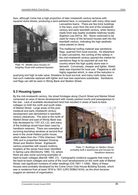
<strong>Lancashire</strong> Historic Town Survey<strong>Colne</strong>face, although <strong>Colne</strong> has a high proportion of later nineteenth century terraces withsquared stone blocks, producing a semi-ashlared face, in comparison with many other east<strong>Lancashire</strong> towns. There are few brick buildingsin the town, even from the end of the nineteenthcentury and early twentieth century, when factorymadebrick was readily available relatively locally(Egerton Lea 2001a, 39). Stone continued to beused for many of the terraced houses well into thetwentieth century, indicating the high aestheticvalue placed on stone.Plate 16: Middle-class houses onKeighley Road with ashlared façadesThe traditional roofing material was sandstoneflags, quarried from local sources. As elsewherein east <strong>Lancashire</strong>, the coming of the railway inthe mid-nineteenth century opened the market forsandstone flags to be exported all over thecountry where the high quality stone was indemand. Conversely, cheaper and lighter, Welshslate was imported for local use. Flagstone is stillhighly regarded which, in view of the reduction inquarrying and high re-sale value, threatens its local survival, and many roofs today havehad such materials replaced with lighter and now less expensive substitutes. Sandstoneroof flags can still be seen in Windy Bank and Skelton Street.5.3 Housing typesBy the mid-nineteenth century, the street frontages along Church Street and Market Streetcomprised an area of dense development with closely packed courts and passageways tothe rear. Lack of available development land had resulted in areas of back-to-backcottages on both the north and south sidesof Market Street. Large areas of this postmedieval and early nineteenth centurydevelopment was demolished in twentiethcenturyclearances. The area to the north ofMarket Street and east of Windy Bank wasfully developed by 1761 (CL L2), and manyof the buildings would have been used byhandloom weavers. There are examples ofsurviving loomshop windows at second floorlevel in the Jovial Hatters public house,which dates from the 1740s (Harrison 1988,168) and in properties between DockrayStreet and Skelton Street. Eighteenthcentury properties with square mullionsPlate 17: Buildings on Skelton Street,kneelers at the eaves have been identified probably built a warehouse and houses forin Spring Lane (McGlinchy 1980, 13), wherehandloom weaversthere are also some surviving examples ofback-to-back cottages (Barrett 1980, 21). Cartographic evidence suggests that many ofthe back-to-back cottages and some of the court developments on the north side of MarketStreet, had significant numbers of cellar dwellings (OS 1851 1:1056). Many of thesehouses were probably developed by the <strong>Colne</strong> Union Club House Building Society, whichwas in existence from at least 1816 to 1831 (LRO DDBd/14/24), as the short terracessuggest an element of organisation.© <strong>Lancashire</strong> <strong>County</strong> <strong>Council</strong> 2005 38