INTRODUCTIONCoronado National Forest is comprised <strong>of</strong> approximately 1.85 million ac, mainly inSanta Cruz, Cochise, Graham, <strong>and</strong> Pima Counties, AZ; smaller parts <strong>of</strong> this non-contiguousNational Forest (see fig. 1) are in Pinal County, AZ, <strong>and</strong> Hidalgo County, NM. The terrain ismostly mountainous <strong>and</strong> typical <strong>of</strong> the Basin <strong>and</strong> Range physiographic province. The l<strong>and</strong>sare utilized in quite variant ways, including a ski resort, recreational lakes <strong>and</strong> reservoirs,grazing, wilderness, natural areas, scientific areas ranging from rare biological speciespreserves to astronomical observatories, public utility areas, <strong>and</strong> mining.<strong>Mineral</strong> deposits formed in Coronado National Forest largely as a result <strong>of</strong> the majorearth-crust deformation <strong>and</strong> igneous rock intrusion which took place during the Tertiary age,<strong>and</strong> particularly during Laramide time, although regional-scale structures <strong>and</strong> deformationaltrends that developed as long ago as Precambrian time influenced mineral depositemplacement. <strong>Mineral</strong> production dates from the late t600's to current operations, but themajor mining eras were: the 1880"s, the early 1900's to about the mid 1920's, <strong>and</strong> the1<strong>94</strong>0's to 1950's. Historical operations were primarily to develop base- <strong>and</strong> precious-metalveins, replacement zones, <strong>and</strong> skarns, all emplaced during intrusion <strong>of</strong> plutons <strong>and</strong> batholithsthat accompanied mountain building. The majority <strong>of</strong> mining operations, historically, wereunderground <strong>and</strong> accessed by shafts or adits. Many shaft operations are inaccessible <strong>and</strong>some <strong>of</strong> the largest sites have already been reclaimed.There are very few currently (19<strong>94</strong>) operating mines. The main active (19<strong>94</strong>) minesare an underground copper-silver skarn in the Santa Catalina Mountains <strong>and</strong> an open-pitoperation for high-brightness marble products in the Santa Rita Mountains. Exploration isfocused on four copper-porphyry deposits, which are being considered for open-pitdevelopment. Three are in the northern Santa Rita Mountains <strong>and</strong> one is in the PatagoniaMountains. There are small-scale active operations: two for aggregate <strong>and</strong> one for opal(Tumacacori <strong>and</strong> Atascosa Mountains).Staff from the U.S. Bureau <strong>of</strong> <strong>Mines</strong> (USBM) have completed a forest-wide mineralresource assessment for both metallic <strong>and</strong> non-metallic mineral commodities <strong>and</strong> an inventory<strong>of</strong> more than 1,100 mine <strong>and</strong> prospect groups in Coronado National Forest. Fieldinvestigations, which included mapping <strong>of</strong> mine sites <strong>and</strong> collection <strong>of</strong> about 4,500 rock-chipgeochemical samples from mineralized zones, were undertaken between the fall <strong>of</strong> 1988 <strong>and</strong>the spring <strong>of</strong> 1992. Assessment <strong>of</strong> the field data <strong>and</strong> publishing <strong>of</strong> the resultant 14resourceassessment/mine inventory reports (one for each Management Unit 2 <strong>and</strong> one forest-widereport addressing industrial minerals) were completed between the fall <strong>of</strong> 1991 <strong>and</strong> thesummer <strong>of</strong> 19<strong>94</strong>. This report isa synopsis <strong>of</strong> all that work, <strong>and</strong> focuses on sites <strong>and</strong>Essentially each separate major mountain range in the National Forest,2IIIIIIIIIIIIIIIIIII
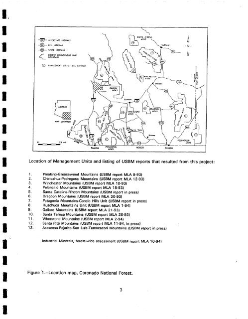
IIIIIIIIQ\sA.rA rcRc~ 1U.S, HICHWAy So(ford --a-FOR[BT MAMAC[I~N'~ r UNITBOUNDARYtJANAGEWENT UNITS--SEE CAPTION~J,P LOC.CTfOH0 25 ml, IRINCONWT.V5Wlllcoi[Ho~ol*s PATAGONM MCX|CO Dougk~$MrNSP£LONCILLO&ITN~JLocation <strong>of</strong> Management Units <strong>and</strong> listing <strong>of</strong> USBM reports that resulted from this project:IIIIiIII1.2.3.4.5.6.7.8.9.10.11.12.13.Pinaleno-Greasewood Mountains (USBM report <strong>MLA</strong> 8-93)Chiricahua-Pedregosa Mountains (USBM report <strong>MLA</strong> 12-93)Winchester Mountains (USBM report <strong>MLA</strong> 10-93)Peloncillo Mountains (USBM report <strong>MLA</strong> 18-93)Santa Catalina-Rincon Mountains (USBM report in press)Dragoon Mountains (USBM report <strong>MLA</strong> 30-93)Patagonia Mountains-Canelo Hills Unit (USBM report in press)Huachuca Mountains Unit (USBM report <strong>MLA</strong> 1-<strong>94</strong>)Galiuro Mountains (USBM report <strong>MLA</strong> 21-93)Santa Teresa Mountains (USBM report <strong>MLA</strong> 26-93)Whetstone Mountains (USBM report <strong>MLA</strong> 2-<strong>94</strong>)Santa Rita Mountains (USBM report <strong>MLA</strong> 11-<strong>94</strong>, in press)Atascosa-Pajarito-San Luis-Tumacacori Mountains (USBM report in press)Industrial <strong>Mineral</strong>s, forest-wide assessment (USBM report <strong>MLA</strong> 10-<strong>94</strong>)Figure '1 .--Location map, Coronado National Forest.3