conservation area statement - Stroud District Council
conservation area statement - Stroud District Council
conservation area statement - Stroud District Council

You also want an ePaper? Increase the reach of your titles
YUMPU automatically turns print PDFs into web optimized ePapers that Google loves.
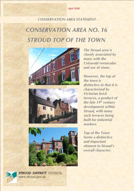
April 2008- CONSERVATION AREA STATEMENT -CONSERVATION AREA NO. 16STROUD TOP OF THE TOWNThe <strong>Stroud</strong> <strong>area</strong> isclosely associated bymany with theCotswold vernacularand use of stone.However, the top ofthe town isdistinctive in that it ischaracterised byVictorian brickterraces, a product ofthe late 19 th centurydevelopment within<strong>Stroud</strong>, with manysuch terraces beingbuilt for industrialworkers.Top of the Townforms a distinctiveand importantelement to <strong>Stroud</strong>’soverall character.STROUD DISTRICT COUNCILwww.stroud.gov.uk
CONSERVATION AREA STATEMENT – CONSERVATION AREA NO. 16 – TOP OF TOWNTABLE OF CONTENTSPART I: INTRODUCTIONWhat is a Conservation Area?Purpose of this documentThe Top of Town Study AreaPART II: ANALYSISThe Analysis of CharacterHISTORY OF TOP OF TOWN♦ Origins of the Settlement♦ Expansion and development of <strong>Stroud</strong>TOP OF TOWN IN ITS SETTING♦ Geology♦ Topography and landscape♦ Approach routes and viewsTHE BUILT ENVIRONMENT♦ The Buildings♦ The SpacesSub Areas in the Top of Town:♦ Sub Area 1: Old Town♦ Sub Area 2: Brick Quarter♦ Sub Area 3: Turn of the 20th CenturyWithin each Sub Area, the following factors areexamined:♦ Origins and evolution of the built environment♦ Uses♦ The Buildings♦ The Spaces♦ Key Buildings and Focal PointsMaterials, Textures, Colours and DetailingTHE CHARACTER OF STROUD TOP OF TOWNA SUMMARYPage 1
CONSERVATION AREA STATEMENT – CONSERVATION AREA NO. 16 – TOP OF TOWNPART III: STRATEGYA review of the Conservation Area boundaryDefining issues and pressuresProposals for the Preservation and Enhancement of theConservation AreaPolicies and Design GuidanceProposals affecting Neutral ZonesListed BuildingsTreesThe Protection pf Unlisted BuildingsBreaches of Planning Control and EnforcementMAPS1. The Study Area and Existing Conservation AreaBoundaries2. Sub Areas within the Study Area3. Sub Area 14. Sub Area 25. Sub Area 36. Proposed Top of Town Conservation Area Boundary7. Listed Buildings and Article 4 Buildings8. Neutral ZonesAPPENDIX ITop of Town Article 4 (2) DirectionPage 2
CONSERVATION AREA STATEMENT – CONSERVATION AREA NO. 16 – TOP OF TOWNPART I: INTRODUCTIONTop of the Town as seen from Butterrow HillWHAT IS A CONSERVATION AREA?The legal definition of a Conservation Area is set out in Section 69 of the Planning (ListedBuildings and Conservation Areas) Act 1990 (herein after called ‘the Act’), as being:“an <strong>area</strong> of special architectural or historic interest, the character or appearance of which it isdesirable to preserve or enhance”.Conservation Areas are primarily concerned with the built environment. They are not appropriateas a means of protecting landscape features, except where they form an integral part of thehistoric built environment.Page 3
CONSERVATION AREA STATEMENT – CONSERVATION AREA NO. 16 – TOP OF TOWNPURPOSE OF THIS DOCUMENTThe Act requires Planning Authorities to reviewtheir Conservation Areas from time to time.This is the main function of this document.Within <strong>Stroud</strong> <strong>District</strong>, there are 42Conservation Areas, some of which were firstdesignated 30 years ago, and the approach todesignation has changed greatly in this time.♦ Firstly, Planning Authorities are nowrequired, in carrying out their planningfunctions, to “pay special attention to thedesirability of preserving or enhancing thecharacter or appearance of theConservation Area” (Section 72 of the Act).♦ Secondly, Planning Authorities shouldpublish proposals for the preservation andenhancement of their Conservation Areas(Section 71 of the Act).In this review, we aim to identify what makesup the “special interest” of the Top of the Town<strong>area</strong> and analyse and define its “character andappearance”. This will provide a firm basisfor planning decisions within the ConservationArea, based on Development Plan policies.It also provides the groundwork for thepreparation of policies and proposals intendedfor the preservation or enhancement of the<strong>area</strong>. These policies may be aimed at specificsites within the Conservation Area, or moregeneral guidance relevant to the wholeConservation Area, such as the use ofappropriate materials.THE TOP OF TOWN STUDY AREAThe Top of Town Conservation Area (No. 16)was designated in February 1978.In this review, we will be looking at theexisting Top of Town Conservation Area andthe land immediately adjacent to it, to see if itis appropriate to amend the boundaries of theConservation Area.The Study Area and the existing ConservationArea boundaries are shown on map 1.Page 4
CONSERVATION AREA STATEMENT – CONSERVATION AREA NO. 16 – TOP OF TOWNPART II: ANALYSISThe architectural and historical evolution of Top of the Town is particularlyevident on Middle Street with its diverse architecture, which spans centuriesTHE ANALYSIS OF CHARACTERThe aim of this section of the Conservation Area Statement is to define what makes up thespecial interest or ‘character’ of the study <strong>area</strong>, in order that this may be preserved andenhanced. Although the character of an <strong>area</strong> may be very obvious in visual terms, it is aboutmuch more than just appearance. History, geography, use and appearance are usuallyintricately and inextricably linked in the evolution of any settlement, and in the creation of itscharacter.♦♦♦♦The origins of a settlement and what has happened to it in the past are often still evident in itscurrent state. Its history can tell us more than simply the date of its buildings: The changingeconomic fortunes of an <strong>area</strong>, important historical events and individual patrons or developersmay have played a role in shaping tastes and styles, as well as influencing the extent ofexpansion.Current or former uses often have implications for the shapes, sizes and types of buildings thatare created, and their massing and relationships to each other. Uses can also create distinctivesounds or smells, adding ‘life’ to the built form.The origins and evolution of a settlement may frequently be dependent on its setting andlocation: these may have suggested a particular industrial, defensive or cultural role, forexample. Furthermore, the location almost always dictates the types of materials and buildingtraditions that prevail.The visual appearance of an <strong>area</strong> is often the cumulative effect of many influences. Theappearance is frequently the aspect that most people relate to in terms of defining what is ofspecial interest and worth preserving or enhancing. The appearance may be made up oflocally typical buildings, or structures of great architectural importance.Page 5
CONSERVATION AREA STATEMENT – CONSERVATION AREA NO. 16 – TOP OF TOWNHISTORY TOP OF TOWNORIGINS OF THE SETTLEMENTAlthough <strong>Stroud</strong> parish was originally part ofBisley, its identity as a distinct unit had begunto emerge by the 13 th century.The manor houses of Paganhill, Over Lypiattand Nether Lypiatt formed the most ancientdwelling places within what was to becomethe <strong>Stroud</strong> parish, but the parish would take itsname from a tiny <strong>area</strong> called ‘la strode’, whichwas first recorded in 1221.The settlement however, seems to haveoriginated a little further up the hill, the earliesthouses being built on the better-drained slopeat the end of the ridge which lies between thetwo streams. The origins of the settlement arerooted in Gloucestershire’s medieval wooltrade, the occupations of spinning and weavingbeing an ever-evolving tradition, whichcontinued to influence <strong>Stroud</strong>’s developmentinto the 20 th century.The early expansion of the settlement, centredaround what is now known as High Street, onthe route between Bisley and Paganhill. Thechurch was built by 1279 and was sited northof High Street. However it was not until 1304that it was assigned parochial rights by therectors of Bisley. The parochial rights made thetiny church the ecclesiastical centre of theparish. The West Tower of the church, datingfrom the 14 th century, still forms part of StLaurence’s today.EXPANSION AND DEVELOPMENT OFSTROUDSixteenth CenturyThe development of the town from the 16 thcentury was fairly rapid, centring on a tradingspace, around an <strong>area</strong> between the 13 th centurychurch and what we now know as High Street.Around 1590, a Market House was built hereby John Throckmorton, lord of Over LypiattManor. Now known as the Town Hall, muchof it survives, with some 19 th century additionsand alterations. The building was originallyfreestanding in the centre of an open square,the market <strong>area</strong>, which was known in the 17 thcentury as ‘the Pitching’, but later became ‘TheShambles’. Trading and other activities alsotook place at The Cross.Seventeenth CenturyBy the early 17 th century, the town had both amarket and fair, and by 1654 the principal innof the town, The George, had opened on thesouth side of the High Street.The development of <strong>Stroud</strong> owes much to thecloth industry, which can be traced back to atleast the 14 th century in the <strong>Stroud</strong> Valley.Gloucestershire had a thriving wool trade, andthe Cotswolds had been used for sheepfarming since ancient times, the quality ofwool produced in the region was renowned. Itwas this industrial and mercantile basis, ratherthan a strictly agrarian one, which was to playthe major role in the town’s expansion andchanging fortunes. By the early 17 th century,textile production was the dominant industrywithin the <strong>area</strong>. <strong>Stroud</strong> town became known asthe centre of this industry, supporting the clothproductionof the surrounding valleys, andbeing described in the mid 18 th century as “asort of capital of the clothing villages’.There are examples of the mid-to late- 17 thcentury mostly within the streets up the hillbeyond the Cross, evidence of the eastwardexpansion which occurred over the 17 th and18 th centuries.It is mainly on Lower Street, Middle Street andWhitehall that surviving houses of the 17 th orearly 18 th century can be seen today. The <strong>area</strong>was developed as a weaving suburb betweenc.1680 and 1720, and its heritage as such canbe detected in the built form of the cottages.Eighteenth CenturyThe focus of the town was still very muchtoward the north and east of High Street duringthe 1700s.In June 1742, the Shambles was the site of asermon preached by John Wesley. During themid 18 th century, a strong Methodist followingPage 6
CONSERVATION AREA STATEMENT – CONSERVATION AREA NO. 16 – TOP OF TOWNdeveloped in the town. The first example of ahexagonal chapel (an architectural formfavoured by Wesley) was built on Acre Streetin 1763.Much of the 18 th century development withinthe town centre has now been demolished oris concealed behind later facades or additions.Some building was carried out on King Street,which was named in honour of the visit ofGeorge III in 1788.There were few large houses in the towncentre during the 18 th century. Most of thewealth of <strong>Stroud</strong> was associated with textilemanufacture and the wealthy clothiersgenerally lived close to their mills. The later1790s however, saw some substantial housesincluded within development (since gone) onKing Street and its western extension,Rowcroft, nearer to the industrial ‘basin’ of thetown. In the upper part of the town, Whitehallis where the most important town houses wereconstructed.The development pattern within <strong>Stroud</strong> and itsenvirons is characteristically an industrial one,with transport routes, mills and manufacturingbases along the valley bottoms. Existingwatercourses provided a means of poweringthe mills, and the extension of the canal systeminto <strong>Stroud</strong> in the late 18 th century furtherstimulated mill building. The <strong>Stroud</strong>waterCanal (1775-79), which stretched from theSevern to <strong>Stroud</strong> at Wallbridge, was linked tothe navigable Thames at Lechlade in 1789 bythe Thames and Severn Canal. It was hailed asa major national artery for commerce, althoughthe high hopes held for its impact on the townfailed to materialise fully.The cloth manufacturing industry reached itspeak towards the turn of the century andduring the first third of the 19 th century.Nineteenth CenturyOver the course of the 19 th century, the towndoubled in size. Early expansion was mainly tothe southwest and was stimulated in 1800 bythe building of the new links from the Bathroad at Lightpill to Rowcroft, and of theLondon Road in 1815. As a result the top oftown ceased to be used as a major route way.The new roads had implications for a numberof existing and new streets in the centre. KingStreet and its continuation, Rowcroft, weregiven greater importance, and were connectedto London Road by a new street, whichbecame Russell Street. By the 1830’s, the streetpattern of <strong>Stroud</strong> town centre, as we know ittoday was emerging, and considerable buildinghad taken place.1800-1840 was a period of growth andexpansion. The new streets were broad andelegantly modelled, in the Georgian and neoclassicalmould. The Subscription Rooms(1833-4) provided a prominent aesthetic andsocial focus for the new part of the town.The new roads and transport links reduced theisolation of the provincial town and improvedtrade. The course of the 19 th century changedthe face of <strong>Stroud</strong>. Reform of industrialpractices throughout the century saw thedisappearance of cottage industry and theconcentration of weaving and textileproduction into a few large mills. The adventof steam power led the <strong>Stroud</strong> mills into fiercecompetition with manufacturing centres in theNorth of England and on the Continent, andthe 19 th century was a period of continualboom and bust.The next phase in the fortunes of <strong>Stroud</strong> camewith the arrival of the Swindon and GloucesterGreat Western Railway line in 1845. Thestation was located south of Russell Street,reasserting the new southwestern emphasis ofthe town centre. The railway provided <strong>Stroud</strong>with an infrastructure for industrial growth.However, the later 1840s and ‘50s were not aperiod of great expansion for the town.Inevitably, the ailing canal system was severelyhit by the railway’s arrival, and from the mid19 th century did little real business.The rapid growth and refinement of early 19 thcentury <strong>Stroud</strong> was slowed, but from 1860 tothe turn of the century, a post-recession boombrought civic and municipal improvements.The Victorian influence on the town is still felttoday. A number of public buildings werePage 7
CONSERVATION AREA STATEMENT – CONSERVATION AREA NO. 16 – TOP OF TOWNintroduced, including the imposing and ornateArt School on Lansdown (1890-9). Everimproving transport links (The MidlandRailway arrived in 1866) brought an influx ofnew industry.Industrial expansion often ran in tandem withsocial improvements during the high Victorianperiod. A leading industrialist and politician,George Holloway (a monument to who issituated on Rowcroft, outside <strong>Stroud</strong> House),pioneered the manufacture of ready-madeclothing and introduced a number of socialreforms to <strong>Stroud</strong> at about the same time thatthe civic movement was gathering pace acrossthe country.In 1855, the Holloway family firm’s clothingfactory inspired the naming of ThreadneedleStreet, on which their factory stood. Messrs.Holloway Brothers’ manufactory used severalof the very newly invented patent sewingmachines.During the late 1870s and 1880s, GeorgeHolloway was responsible for much of theeastward expansion along Horns Road,building a large terraced estate of working classhouses. Brick terraces formed a significantproportion of late 19 th century developmentwithin <strong>Stroud</strong>, and added a distinctive elementto the town’s character. The form was adaptedfor purposes ranging from artisan cottages togrand ranges of commercial and retailbuildings.Twentieth Century and Present Day:In the early 20 th century, <strong>Stroud</strong> was still athriving manufacturing town, with a number oflarge employers with substantial premises inand around the town centre.In general, the 20 th century’s contribution tothe townscape has not been overwhelminglypositive. Large-scale redevelopment has oftencreated large and insensitively sited newbuildings, including Merrywalks shoppingcentre and the Police Station. Increased car usehas resulted in large car parks and roadwidening schemes, involving much demolitionand disruption to the historic pattern of <strong>Stroud</strong>.Cornhill, the link road constructed in the1980s, ripped through the Cross, resulting in aloss of the continuity between High Street andNelson Street and severing the link betweenthe old medieval nucleus and <strong>Stroud</strong>’s first‘suburb’ to the east.While 19 th century redevelopment swept awaymany of the town’s early buildings, the 20 thcentury’s impact has been even greater, withlittle of positive townscape value created inreturn.Above: Statue of GeorgeHolloway, industrialist,philanthropist andpolitician.Above: Buildings on the HighStreet, which were savedfrom demolition in 1980.Page 8
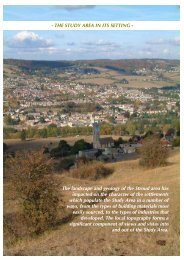
CONSERVATION AREA STATEMENT – CONSERVATION AREA NO. 16 – TOP OF TOWNTOP OF TOWN IN ITS SETTINGThe landscape and geology of the <strong>Stroud</strong> <strong>area</strong>has impacted on the character of the settlementin a number of ways, from the types ofbuilding materials most easily sourced, to thetypes of industries that developed. In visualterms, the surrounding landscape influencesthe first impressions gained on approach to thetown, and the local topography forms asignificant component of views and vistas intoand out of the settlement.An abundance of natural watercourses madethe <strong>Stroud</strong> Valleys ideal as the base formanufacturing and industry, as the flowingwater provided power for the mills. A goodclean water supply was also necessary forwashing the wool used in cloth production.Industrial development naturally occurredalong the valley bottoms, notably the FromeValley, where mills could also be close totransport links.Today, <strong>Stroud</strong> is at the centre of an extensivenetwork of road and rail links and waterways.Many of the earliest roads that served thesettlement ran along the tops of the hills, andtheir extreme steepness and muddiness was adeterrent to much traffic. This certainlyinhibited transport and trade links and ratherisolated the early settlement. However, the 18 thand particularly the 19 th century saw transportimprovements, including the construction of anumber of major new turnpike roads, whichran along the valley bottoms, many of whichreplaced existing hilltop routes.Belmont Road stepping down the hill towards Bisley Road. Thedistinctive wooded valleys, often glimpsed from within the townforming a backdrop.Page 9
CONSERVATION AREA STATEMENT – CONSERVATION AREA NO. 16 – TOP OF TOWNGEOLOGYBetween about 185 and 140 million years ago,during the Jurassic period, a vast limestone beltwas created, stretching between Lincolnshireand the Dorset coast. The Cotswolds, a regionof ambiguous boundaries, is usually held toconstitute the highest part of this belt, a plateauthat rises from the east in Oxfordshire anddescends in a dramatic escarpment to the west,within sight of <strong>Stroud</strong>.During the Jurassic period, a shallow seacovered the <strong>area</strong>, in which a sequence ofsediments settled into alternating layers or‘strata’ of clay, sand and limestone. Althoughthe beds of sediment were each laid down on avirtually horizontal level, subsequent processeshave resulted in shifts in the terrain, so that, inplaces, strata of quite diverse ages andsubstance have ended up next to each other.The whole Cotswold plateau has been tilted,so that the west has risen up, while the east hassunk. Erosion and climatic changes have alsoplayed their part in shaping the landscape.In the past, the whole Cotswold formation wasknown as the Oolite, due to the prevalence ofthis form of limestone throughout the region.Limestone, and in particular oolitic limestone,is extremely permeable, and where it meetsbeds of impervious clay, water is driven out inthe form of springs. Hence the Cotswolds areriddled with streams and brooks as well asrivers. These have been highly active in theformation of the topography, carving deep andcomplex valleys into the ‘Oolite’ plateau, aprocess that continues and means that thelandscape is ever changing.Due to its porous nature, oolitic limestone is‘soft’ when it is newly extracted and may beeasily worked. The mass of oolite is in twobasic layers, separated by a narrow bed ofFullers Earth: the older, deeper layers beingknown as the ‘Inferior Oolite’ and the upperlayers as ‘Great Oolite’.The tilt of the Cotswolds means that the lowerlayers, the ‘Inferior Oolite’, are exposed alongthe western escarpment, where they are moreeasily accessible than in the eastern Cotswolds.The hills encircling <strong>Stroud</strong> were particularlyrich in good quality Lower Inferior Oolitestones, known by masons as ‘Freestones’, dueto the ease with which they can be cut anddressed. Among these is Lower Freestone, ofwhich the fine Painswick Stone is a variety,and Lower Limestone, the eldest of the strata,of which there is a large outcrop at FrocesterHill. Upper Freestone is of poorer quality,mostly used for burning, to create lime mortarsand plasters. At <strong>Stroud</strong>, though, it wassufficiently good to be used for many of thetown’s ‘rock-faced’ rusticated buildings.TOPOGRAPHY AND LANDSCAPEThe town of <strong>Stroud</strong> is famously located at thecentre of what is known as the ‘Five Valleys’.These comprise the valleys of the PainswickStream to the north, the Slad Brook to thenortheast, the river Frome, entering <strong>Stroud</strong>from the southeast and exiting to the west, andthe Nailsworth Valley to the south.To its north, south and east, the town issurrounded by a complex pattern of hills,valleys and coombes.The range of hills to the south of <strong>Stroud</strong>,stretching westward from those topped byRodborough Common and Selsley Common, isterminated by the distinctive form of FrocesterHill on the Cotswold escarpment. From theescarpment, the Cotswold landscape descendsto the flat plain of the Severn Vale.The peaks between the deep valleys formed bythe Frome, Slad Brook and Painswick Streamare riddled with many further valleys. Manyare carved out by the abundance of tributarystreams and brooks, as at Puckshole, where theRuscombe Brook slices southwards betweenthe hill-top villages of Whiteshill and Randwickto the north of <strong>Stroud</strong>.The topography of deep valleys, hills andwinding roads creates endlessly surprisingviews. The traveller’s sense of direction is oftenchallenged, and distant landmarks are revealedthrough vistas in unexpected places. The viewsalso create a warped sense of scale at times:from hilltop to hilltop, far away villages appearrelatively close, with expanses of countrysideor town concealed in valley bottoms or justover the crest of a hill.Page 10
CONSERVATION AREA STATEMENT – CONSERVATION AREA NO. 16 – TOP OF TOWNThe town is not entirely encircled by hills,however. To the west of <strong>Stroud</strong>, the FromeValley broadens, opening out onto the SevernVale. The western limits of the Frome Valleyare marked by Doverow Hill on the north sideand by Frocester Hill on the south. The twohills are distinctive landmarks and frame thewestward vista towards the Severn. At its‘mouth’, the valley base is almost 3km wide(over a mile and a half).APPROACH ROUTES AND VIEWSA significant urban mass is visible on manyapproaches to the town. Yet much of thatwhich may be visually perceived as ‘<strong>Stroud</strong>’,is in fact formed by outlying villages andsettlements, which have become absorbed intothe <strong>Stroud</strong> sprawl. Notably, Rodborough,which sits prominently on a hillside to thesouthwest, lies beyond the Parish boundary.Visually, Rodborough contributes significantlyto the urban mass, yet it is in no sense part of<strong>Stroud</strong> town or parish.The original medieval core of the settlement issited on sloping ground on the lower levels of<strong>Stroud</strong> Hill, in the fork between the RiverFrome and the Slad Brook. Within this <strong>area</strong>,the Top of Town, the land rises in a west toeasterly direction. Today’s town centredescends from this, towards the Frome valleybasin, which accommodates the railway, canaland industrial <strong>area</strong>s of Wallbridge andCheapside.Being on comparatively low ground in relationto the surrounding hills, the town centre is notclearly visible from many points on approachto <strong>Stroud</strong>. In its earliest times, the settlementwould largely have been concealed within theundulating landscape. On many of the town’sapproach routes, the developed <strong>area</strong>s of <strong>Stroud</strong>Hill, Uplands and Rodborough are among thefirst discernable signals to the existence of asettlement.On a number of approaches, however, theroad arrives in the heart of town, having givenfew visual clues to the proximity of anysignificant settlement at all. This is true of thePainswick Road (A46), constructed in 1818.Until just north of the parish boundary, thetown and all high ground to the south areconcealed by trees near to the road and by thevalley. Within the boundary, the road runs lowalong the valley bottom, and from this vantagepoint there is no hint of the approachingsettlement at all. The tall trees bordering theroad at Stratford Park conceal any potentialview of built up <strong>area</strong>s to the south and west; itis only towards the termination of BeechesGreen that an urban vista opens out.A similar effect is experienced along the SladRoad from the northeast. In places, thesteepness of the valleys around <strong>Stroud</strong> hasmeant that parts of the town have avoideddevelopment and narrow fingers of green landproject into the town. Along the Slad Valley,undeveloped fields reach quite close to theheart of the town. Despite the extensivedevelopment of Uplands (to the right) and theTop of the Town above Summer Street (visibleacross the valley to the left), the effect is tocontinue the sense of the Slad Road’s dramaticrural landscape, almost to the point of arrival inthe centre of town. Rodborough Fields, to thesoutheast have similarly remained green andundeveloped.The extension of the countryside into the townthus occurs both physically and visually, thegreen horizons being visible from within thevery centre of town. This forms a verydistinctive and unusual characteristic of <strong>Stroud</strong>.There are a number of features which formstrong visual points of reference on many ofthe approaches to <strong>Stroud</strong>, some of which <strong>area</strong>lso conspicuous landmarks viewed fromwithin the town itself.Among the distinctive and most frequentlyvisible natural forms are the, alreadymentioned, Doverow Hill and the Escarpmentat Frocester and Sandford’s Knoll. These,together with the scrubby land of RodboroughCommon are glimpsed in views even from theheart of the town. Approaching from the eastand north, the River Severn is also sometimesdistantly visible beyond the town.Page 11
CONSERVATION AREA STATEMENT – CONSERVATION AREA NO. 16 – TOP OF TOWNThe unique tower of Selsley Church is amongthe most conspicuous built features of <strong>Stroud</strong>’ssetting, visible from within the town and manyplaces on approach to it.The spire of St Laurence’s Church, despitebeing on relatively low ground, is alsoprominent, especially from within the towncentre. All Saints Church in Uplands isfrequently identifiable, even from afar, itsdisproportionately large size in relation tosurrounding buildings sometimes warping anysense of scale or distance.Other highly conspicuous and less sympatheticlandmark buildings include the tower blockflats on Summer Street and the Law Courts andPolice Station building, both of which occupyextremely prominent sites on <strong>Stroud</strong> Hill. TheLaw Courts building is particularly dominant,conspicuously visible in views from almostevery approach route into the town.Page 12
CONSERVATION AREA STATEMENT – CONSERVATION AREA NO. 16 – TOP OF TOWNTHE BUILT ENVIRONMENTThe built environment of the ConservationArea can be very simply divided into two mainelements, namely: -♦ The buildings themselves♦ The spaces adjacent to and surrounding thebuildings.The next part of this document usesthese two basic headings to examinewhat makes up the “specialarchitectural and historic interest”of the <strong>area</strong>1. THE BUILDINGSWhilst some buildings may be individuallyimportant in a Conservation Area, it is therelationship of buildings one to another,their layout in relation to the streets andfootpaths, and their density, which so oftendefine the character of the <strong>area</strong>.The architectural style and materials of thebuildings will be important factors indetermining what makes the Area “special”.Current and former uses often impact on theforms and styling of individual buildings,their relationships to others nearby and thelevels of activity or motion in the <strong>area</strong>, all ofwhich comprise significant components ofthe Area’s character as a whole.2. THE SPACESThe land around buildings falls into avariety of types including roads, streets,footpaths, gardens, parks, fields,watercourses – the list is almost infinite.Widths and alignments differ, some containgreen features such as trees and grass, someare public and some are private spaces.Page 13
CONSERVATION AREA STATEMENT – CONSERVATION AREA NO. 16 – TOP OF TOWNSUB AREAS IN THE TOP OF TOWNWithin a Conservation Area, it is sometimespossible to identify parts of the Area, whichdiffer in character. Key factors in definingwhere one part of the Conservation Area differsfrom another include the density of buildings,and their relationship to one another and to thehighways. Where clear differences do exist,these are identified as sub-<strong>area</strong>s and theConservation Area is examined using thosesub-<strong>area</strong>s.Three <strong>area</strong>s have been identified as being sub<strong>area</strong>swithin the Top of the Town Study Area.See map 2.To a large extent, these sub-divisions reflect thehistorical evolution of the town centre.Changing tastes, styles and technicalcapabilities influenced the plan forms andbuilding sizes, creating pockets of not onlydiffering architectural styling, but also of variedscale, sense of enclosure and distinctivecharacter.Sub Area 1:The Old TownA large proportion of the StudyArea, taking in most of the Topof Towns ‘historic core’. Thiscovers most of the Western endof the Study Area, being Westof a line along Field Road,Trinity Road and Hollow Lane.Sub Area 2:The Brick QuarterThis covers over half the StudyArea, incorporating streets tothe east of the same line andincluding the two terraces atthe South end of Field Road.Sub Area 3:The Turn of the 20 th CenturyThis sub <strong>area</strong> is notconcentrated to one <strong>area</strong> butcomprises several smaller <strong>area</strong>swithin the whole. These arethe hospital site off TrinityRoad, the school site offParliament Street and an <strong>area</strong>off Castle Street, which includesthe school and adjacentbuildings.Analysis: The Built Environment – Sub Areas Page 14
CONSERVATION AREA STATEMENT – CONSERVATION AREA NO. 16 – TOP OF TOWNSUB AREA 1: THE OLD TOWNThe BuildingsAlthough this sub <strong>area</strong> incorporates parts,which are not strictly of Old Town origins, thewhole sub <strong>area</strong> shares very similarcharacteristics of space, scale, use andjuxtaposition of styles and eras. Due to its longhistory and its variety, the character of this sub<strong>area</strong> is the most complex of the three to define.Middle Street is the main artery through thesub-<strong>area</strong>, and comprises the earliest part of the<strong>Stroud</strong> settlement with many houses survivingfrom the 17 th and 18 th centuries. Sub streetsand lanes branch off, most of which follow theline of the adjacent plots. Castle Pitch andSpring Lane for example, follow the historicboundary of The Castle. (See map 3)The Old Town plan is defined by the historicstreet layout and is the result of organicexpansion rather than planned extensions tothe settlement. The pattern of the buildingshere is defined by the historic street layout,with the buildings being generally grouped interraces or in closely-knit ribbon form.alleys and passageways allow an occasionalview into the rear. An exception to this rule isfound in Castle Street where a few individuallarge houses in large plots can be found.None of the streets in this sub <strong>area</strong> have beenlaid out in a regular form or to a pre-arrangedplan. Consequently few are straight andbuildings are often positioned with norelationship to their neighbours. The density ofbuildings is generally high.The prevailing use within this sub-<strong>area</strong> isresidential. There is a virtually continuousfrontage of houses along Middle Street, LowerStreet and Whitehall. There are also severalservice buildings such as public houses,churches and a school within the <strong>area</strong>, mostbeing located in the narrow side streets, whichbranch off the main through roads.Incorporating the earliest parts of the originalsettlement, this sub <strong>area</strong> features buildingsdating from the 16 th to the 20 th century, thebroadest range of dates and styles of all the sub<strong>area</strong>s in the Study Area.Many of the buildings have been brought rightup to the footpath, though some are set behindrailings, walls or small gardens. The buildingsare irregularly spaced and the presence ofMedieval, Georgianand Victorianbuildings lyingadjacent to oneanother in MiddleStreetPage 15
CONSERVATION AREA STATEMENT – CONSERVATION AREA NO. 16 – TOP OF TOWNOne of the earliest <strong>area</strong>s of development wasthat around Middle Street and Lower Street,which were created largely in the late 17 th andearly 18 th centuries. In general, the buildingshere are of a modest nature and also whollyintermixed with Mediaeval, Georgian andVictorian buildings standing adjacent to oneanother.Key buildings and focal pointsThe Castle in Castle Street is a conspicuousbuilding set within large grounds behind a wallof stone. It was constructed in 1610 by Simonand Jane Chadwell then re-fronted by CharlesFreebury about 1781. At this time it was refrontedin Ashlar stone which included abracketed cornice, pedimented porch on ioniccolumns and sash windows. Attached to thenorth garden wall are two castellated turrets.This building became the home of P H Fisher,a local attorney in 1809 who occupied it untilhis death in 1873. He is known locally for hisbook, ‘Notes and Recollections of <strong>Stroud</strong>’ firstpublished in 1871.Piccadilly Mill, located in Piccadilly, is theonly large industrial building in this sub <strong>area</strong>.It is constructed of red brick with yellow brickdetailing in the form of Voussoirs over thewindows. Though large, it is well hidden fromany significant view by virtue of its locationsurrounded by the houses and cottages inMiddle Street and Lower Street. Glimpses ofthe mill can be obtained from Lower Street.Whitehall terrace is one of the most imposingof classical edifices within this sub <strong>area</strong>. Theterrace was built on the edge of the town inwhat was considered a healthy situationappropriate for successful tradesmen. It isconspicuous both as a result of its detailing, thebuildings are adorned with elaborate cornices,bay windows and stone porches withrusticated pilasters, and as a result of itslocation on high ground at the upper end ofMiddle Street, where a good clear view of thefront elevation is possible.In addition to the more obvious focal pointsand landmarks, there are a number of moreordinary buildings in the sub <strong>area</strong> which makevaluable contributions to its character, oftensimply by providing a good, unprepossessingfoil or context for more architecturallysignificant buildings.Among these are the enormously variedbuildings on the north side of Middle Street.The small-scaled terraced cottages such asnumbers 6 to 18 Lower Street and the whollyvernacular and well preserved stone cottages atthe south west end of Trinity Road. Somebuildings gain distinction through quirky andindividual detailing, thus avoiding beingcompletely overshadowed by their neighbours.This is true of numbers 22 and 23 Lower Street,the Bisley House public house in Middle Streetand number 5 Trinity Road.Left: The Castle, CastlePitchBelow: Whitehall Terrace,WhitehallPage 16
CONSERVATION AREA STATEMENT – CONSERVATION AREA NO. 16 – TOP OF TOWNSome buildings, of varied ages and styles, haveadditional small-scale details, which makethem interesting. These buildings includenumber 3 Middle Street with its decorativebarge boards and 19 th century ornate shopfront, number 18 Lower Street which has asundial and date inscription of 1695 andnumber 15 Lower Street which has roughcastrender finished at the corners with smoothrender detailed to represent corner stones.Modern infill buildingsWithin this sub <strong>area</strong>, there are few majorbuilding developments of the late 20 th century.The two most significant ones are in MiddleStreet, these being the garage and the newhouse opposite and the new houses in SuttonPlace. Neither of these relate to the characterand appearance of the rest of the buildings inthe sub <strong>area</strong>.Significantly, these developments are ofdecidedly modern design, avoiding any kind ofpastiche and the buildings deviate from theprevailing character of the Street with a lack ofclassical or vernacular detailing.Above:Street.Modern infill developments in MiddlePage 17
THE SPACESCONSERVATION AREA STATEMENT – CONSERVATION AREA NO. 16 – TOP OF TOWNOpen space takes two main forms within thissub-<strong>area</strong>:• Streets and roads• Private gardens and yards to the rear ofstreet-fronting buildingsThere is little public open space within thissub-<strong>area</strong>, examples being the wide pavementcreated by the junction of Nelson Street,Middle Street and Castle Street and the oldroad, now blocked off which formerly led fromMiddle Street to the Chapel in Chapel Street.The narrowness of many of the roads and sidestreets contributes to an over all human-scaledemphasis, few spaces being any broader thanthe height of the buildings lining them. Thespaces are well enclosed, with buildingsforming an almost continuous frontage alongmost streets.Motor traffic now flows through all of thehistoric streets. Having once formed part of theroute to Bisley, today it is used more forlocalised and domestic access.Though many buildings have small frontgarden plots which add to the colour diversityof the <strong>area</strong>, most private land is to the rear ofthe buildings and is concealed from view bysurrounding buildings and boundary walls.This renders their visual impact on the mainstreetscapes as minimal. However, these <strong>area</strong>sare more noticeable and important whenviewed from side streets and the mainpedestrian alleys, footpaths and vehicularaccesses between and behind the buildings.There is very little green space in the ‘OldTown’ sub-<strong>area</strong>, although the green of hills andtrees beyond the sub-<strong>area</strong> and the town centreare frequently visible from within. The numberof trees visible from the streets is limited andall are in private gardensWhere trees are to be found they are normallyin groups in older well-established largegardens, such as within the grounds of TheCastle, Spring Hill and Corbett House.The blacktopped highways dominate much ofthis <strong>area</strong> the harshness of the road, being afurther modern intervention, which is notstrictly in character with the majority of theOld Town. However, exceptions to this rulecan be found, for example to the front of thehouses on the south side of Whitehall, thegravel track with shrubby verge adds a pleasingbreak to the harshness of the hard surfaces.At the top of Castle Pitch, a small patch of theoriginal cobbled road surface is visible whichgives an important clue as to the historicappearance of this part of the ConservationArea.Path from Middle Street toChapel StreetEstablished trees are animportant focal pointrising above Field RoadPage - 20 -
CONSERVATION AREA STATEMENT – CONSERVATION AREA NO. 16 – TOP OF TOWNSUB AREA 2: THE BRICK QUARTERThe BuildingsThis is the largest of the sub <strong>area</strong>s and thebuildings are of a different nature to those ofthe Old Town. This is due to the shorterlifespan of the sub <strong>area</strong> and the technical andvisionary capabilities of the 19th and 20thcenturies. [Map 4]Of the whole study <strong>area</strong>, sub <strong>area</strong> 2 is the mostunified in terms of materials and the era fromwhich it dates.The <strong>area</strong> is really a product of high Victorianexpansion and civic improvements, makinguse of the brick terrace, the archetypal late19th century built form. The form ofconstruction of these buildings is simple indesign and massing and on the whole isharmonious and uniform in its appearance.In the mid 19th century the Bisley Road, HornsRoad and the <strong>area</strong> in between was largelyundeveloped. Then, in the late 19th centurythe <strong>area</strong> in between was rapidly developedwith rows of Victorian terraces or detached andsemi-detached villas.The development of this part of the town isclosely associated with two particular people.Between the years 1870 and 1880 GeorgeHolloway was responsible for a number ofsocial improvements to the town anddeveloped the red brick terraces of workingclass houses in the Horns Road <strong>area</strong>. Theestate comprises a double row of brick terracesnorth of Horns Road with shorter terraces tothe south of it. These terraces form a verydistinctive element to the appearance of the<strong>area</strong>.From 1882 and up until the end of the century,Bisley Road was developed with larger villas inpairs or threes some of which were modestlydecorated with Tudor style windows, Dutchgables or barge boards. On the south side ofBisley Old Road and Belmont Road smallersemi detached brick villas were constructed.Above: Dutch gables on a largehouse on Bisley RoadRight: Smaller semi-detached villasin Belmont Road.Page - 21 -
CONSERVATION AREA STATEMENT – CONSERVATION AREA NO. 16 – TOP OF TOWNLike the Old Town, the majority of this <strong>area</strong> istoday taken up by residential properties.Additionally there is a public house, whichcompliments the residential function. Theatmosphere is generally busy, especially atnight and at weekends when most people <strong>area</strong>t home.There are no significant through roads in the<strong>area</strong>, most of the streets serving predominantlyas access to the houses.The alignment of frontages is very closelyallied to the street layout. In the Horns Road<strong>area</strong> the roads and the terraces were createdaltogether, which resulted in continuous rowsof buildings with no curves or staggers tosweep round bends in the road. Somestaggering does occur in Bisley Road, but thisis very subtle with small-scale return endprojections.Most of the 19th century buildings in this sub<strong>area</strong> were built to house the workers of nearbymills. The density of buildings here is high. Inthe Horns Road <strong>area</strong> the buildings areconcentrated in long terraces separated byaccess footpaths shared by several cottages.The long gardens, driveways and shared accesspaths between the terraces create some openspace. The terraces rise in long rows with thecontours of the land and as a result glimpses oflower terraces and of the valleys beyond areobtained from gaps between the buildings.In the Bisley Road and Belmont Road <strong>area</strong>s,the individual or detached houses are alsogrouped together, however with some beingset further back from the road in larger plotsand with spaces between the buildings, thedensity is slightly lower.building styles, and making for an interestingstreet scene.Towards the top end of Bisley Road there arefive pairs of semi-detached properties, whichhave distinctive gables. Numbers 102-108 arestepped back from the road and are lower thanthe street level; three semi-detached pairs aredirectly on the pavement. The steeply pitchedgables of the houses make for an interestingjuncture at the top of the hill.Above: Numbers 94-96 Bisley RoadYork Lodge (shown below) is a good exampleof the great variety and detailing of some 19 thcentury properties, which can be found onBisley Road. York Lodge displays an attractivearray of materials, which were popularlyemployed by 19 th century builders andarchitects. The substantial red brick house isinterjected with buff brickwork, and decorativedetails such as diaper work, terracotta panelsand an Italianate tower.Key buildings and focal pointsBisley RoadTowards the end of the nineteenth centuryBisley Road saw the development of largevillas in pairs or threes. Some of the villas areornately decorative, with each set of villasbeing uniquely designed by individual buildersrather than along row of terraces such onHorns Road, which are built to the samedesign by the same builder. This has resultedin Bisley Road demonstrating a diverse array ofLeft: YorkLodgePage - 22 -
CONSERVATION AREA STATEMENT – CONSERVATION AREA NO. 16 – TOP OF TOWNDutch gables on numbers 37-39 and 45-47 <strong>area</strong>nother quirky and individual feature,combining the mix of local material, stone andbrick. Another characteristic feature of the<strong>area</strong>, bay windows, are found in abundance onthis street. Some of these are double height,but most are single storey giving additionalspace to the front rooms, they normally havepitched roofs to match the main roof.The predominate red brick properties whichline Belmont Road take on a uniformappearance however, on closer inspection thebuildings all have individual detailing, such asdentilling, multi-coloured brick banding andwindow and door surround designs.Horns RoadThe unified terraces along Horns Road are agood example of 19 th century workers housing,built by George Holloway, a local industrialist,during the late 1870s and 1880s. The terracesare less fussy in its detailing, and they haveclearly been planned as a unit, rather thandeveloped in a piecemeal way, as with thehouses on Bisley Road and Belmont Road.Modern and twentieth century developmentAbove: Dutch gables and a bay window onnumbers 37-39, Bisley RoadSouth side of Bisley Old Road and BelmontRoadThe lay of the land has ensured that BelmontRoad has taken on a stepped nature and hasresulted in the semi-detached properties risingvery steeply at a right angle from Bisley Road.As a result it is possible to see the backs ofproperties, as well as the front, clearly. Thechimneys, which gradually step upwardstowards Bisley Old Road, only add to the senseof incline.There has been an amount of developmentduring the 20th century, most notably in therear garden plots to the rear of the Horns Road<strong>area</strong> terraces where a series of garages andsheds have been constructed. These buildingsare an unfortunate eyesore, which have bothdestroyed the layout of the garden plots anddevalued the appearance of the originalterraces. Likewise the 20th century garagespositioned at the end of Bisley Road and HornsRoad create a visual blot on a significant entrypoint to the sub <strong>area</strong>.Below: The terraceduniformity of Horns RoadPage - 23 -
THE SPACESCONSERVATION AREA STATEMENT – CONSERVATION AREA NO. 16 – TOP OF TOWNOn the whole, the Brick Quarter is made up ofstraighter streets than the lanes of the OldTown.To the north of the sub <strong>area</strong>, the density ofbuildings decreases, many more substantialhouses being detached or semi-detached andwithin their own garden grounds. Until theearly 20th century, parts of sub <strong>area</strong> 2 wereconsiderably leafier than they are today. Manyof these have now lost their enclosure and areincreasingly being used as hard standing andparking spaces.Again, the predominant ground surface here isthe black top of the roads and pavements.Some private gardens offer a contrast to thesehard surfaces with lawns, shrubs and flowers,however the impact of this is not great as themany car parking bays have been created atthe bottom the surface of which is commonlyconcrete.The many footpaths, which dissect the <strong>area</strong>and link the terraces to the principal roads addsignificantly to the feeling of space and are animportant characteristic of the <strong>area</strong>.Tree cover is similar to that in the Old Townbeing limited to examples only being found inprivate gardens, or <strong>area</strong>s of wasteland, such asthe land to the rear of Mount Pleasant terrace.Above: Footpaths dissectingthe <strong>area</strong> create open spaceand are an importantcharacteristic of the <strong>area</strong>.Left: Some private gardensoffer a contrast to thepredominantly hard groundsurfaces.Page - 24 -
CONSERVATION AREA STATEMENT – CONSERVATION AREA NO. 16 – TOP OF TOWNSUB AREA 3: TURN OF THE 20 THCENTURYThe BuildingsThis sub <strong>area</strong> consists primarily of largerdetached buildings located within moreextensive grounds. [Map 5]This sub <strong>area</strong> contains a number of piecemealdevelopments, which occurred over the courseof the 19th century. All of the buildings are orwere originally public service buildingsconstructed by various public bodies to serveeither the local community or, as in the case ofthe hospital, <strong>Stroud</strong> as a whole.Trinity ChurchTrinity Church was opened in 1839 with theaim of serving the top of town as a chapel ofease to the Parish Church. The building isconstructed in the Early English style of gothicarchitecture, which dates from 1190 – 1250.This was the worship place of P H Fisherwhose tomb lies in the churchyard.The majority of the buildings in this sub <strong>area</strong>are accessible in some form to the public. Themost used building being the hospital.Perhaps the most valuable role of this sub <strong>area</strong>,though, is in providing services to an otherwisepredominantly residential <strong>area</strong>.General HospitalThe original <strong>Stroud</strong> Dispensary was locatednear the Subscription Rooms in the towncentre and in 1835 a casualty hospital waserected adjacent to it. However, by 1872 thenumber of patients had increased to such anextent that a new hospital was deemednecessary. William Cowle donated one acre ofland adjacent to Trinity Church for the erectionof the new hospital, and a local widow gavethe sum of £1000 for the building. Thisdonation started the fund for the new building,which was finally opened in 1875 at a totalcost of between £6 - 7,000. The originalbuilding had 30 beds. A first extension wasadded in 1890 and a further wing after the FirstWorld War to commemorate peace.Above: Trinity ChurchMethodist ChapelThe Methodist Chapel in Castle Street wasconstructed in 1875 – 6, and was extendedwith the addition of a classroom block beingadded to the rear in 1908. It was converted tohousing in 1985.Above: The Methodist Chapel,Castle StreetAbove: General HospitalPage - 25 -
CONSERVATION AREA STATEMENT – CONSERVATION AREA NO. 16 – TOP OF TOWNParliament Street SchoolParliament Street School was constructed in1883 – 4 of ashlar stone in Tudor style. It wasbuilt by the <strong>Stroud</strong> School Board, whichformed in 1881. The building was enlarged in1898 and, more recently, in 1990, convertedinto <strong>Stroud</strong> Registry Office.THE SPACES IN SUB AREA 3:Like the rest of the Top of the Town, there islittle open space within this sub <strong>area</strong> althoughthe public are allowed into some of thecurtilages in association with the use of thebuilding.The tree cover is also relatively limited withonly a few examples being found amongst thebuildings. As a result the colour of the <strong>area</strong> isdominated by the black pavements, car parksand playgrounds. In some <strong>area</strong>s such as thechurchyard, the hard surfaces are broken by<strong>area</strong>s of grass.Blackboy CentreThe Blackboy School, now a teacher’s centre,in Castle Street, opened in 1844 as a NationalSchool for girls. The school got its name fromthe Black Boy, a Jack Clock of 1744 which waspreviously located on the front of the Duke ofYork in Nelson Street. The clock waspurchased by public subscription and set up onthe front of the school. In 1969 the schoolbecame the teachers centre.Above: The views up Trinity RoadPage - 26 -
CONSERVATION AREA STATEMENT – CONSERVATION AREA NO. 16 – TOP OF TOWNMATERIALS, TEXTURES, COLOURS ANDDETAILINGBy necessity builders in the past usedmaterials, which were available locally and<strong>Stroud</strong> was no different, with early <strong>Stroud</strong>buildings being constructed from stone andtimber.There are several fine examples of buildingsdating back to the 17 th century in <strong>Stroud</strong>displaying traditional construction techniquesand good architectural detailing. It is alsopossible to identify within <strong>Stroud</strong> that withimproved transport and more advancedmanufacturing techniques, from the 19 thcentury, builders had a wider choice ofmaterials such as Welsh roof slates and redstock bricks. This shift in materials isdemonstrated within <strong>Stroud</strong>.Being close to the Escarpment, <strong>Stroud</strong> has hadaccess to the local freestone. This ooliticlimestone was fine, easily cut and of sufficientquality to create dressed stone blocks anddetails, as is evident in many of the buildingsin this <strong>area</strong>Early on the light creamy golden limestone wasused mostly in the form of rubble, especiallyon rear or side elevations, often squared andcoursed and juxtaposed against the dressedashlar construction of the front elevations ofthe buildings. This can be seen for example, atFern Rock House, Middle Street. The rubblehas an attractive textural quality while theashlars attractiveness is in its detailing.The most imposing building in this is the Castlein Castle Street, which is a large 17 th centurybuilding, remodeled in the 18 th and issurrounded by boundary walls containingmock castles.The entrance to theCastle, Castle StreetCharacteristics of the local building vernacularalmost always originated from more than justwhim; details evolved to cope with the specificlimitations of the materials commonlyavailable, as well as to accommodate the usesmade of the buildings and to protect againstweathering and the climate.The insertion of dressed stone windows intorubble walls, for example, had a bearing on thefenestration, or arrangement of windowswithin an elevation. To maintain structuralstability in the rubble, the windows had to beplaced as far from the corners of the buildingsas possible. Stone hood mouldings (as seen, forexample, on buildings of varied scale andstatus including 22, 24 and 44 Middle Street)evolved to help divert rainwater away fromwindows and doors. Water otherwisestreamed off the gutter less roofs, straight downthe wall face.Above: 3,MiddleStreet, dripmoulds andcrosswindowsThe vernacular window, consisting of stonemullioned casements, sometimes with stonetransom, often with stone hood moulding,appears in many guises throughout the OldTown. In addition to being one of the mostdistinctive features of local 16 th and 17 thcentury building, the form has been adaptedand readopted over the centuries, and hascontinued to be used as a conscious stylisticdevice in the 19 th and 20 th centuries. Forexample numbers 22 and 23 Lower Street areof mid 19 th century construction but includeashlar casements with mullions and transoms.One of the earliest and still one of the mostdistinctive characteristics of buildings in theOld Town <strong>area</strong> is the steeply pitched roof.Although many buildings here have since losttheir stone slates, the basic form of the originalpitched roof remains.Page - 27 -
CONSERVATION AREA STATEMENT – CONSERVATION AREA NO. 16 – TOP OF TOWNThis steeply pitched roof was uniquely adaptedby <strong>Stroud</strong> valley builders, who seized upon thepotential for the use of this attic space. Theeconomy of <strong>Stroud</strong> was dependent to such anextent on the production of cloth that manyhouses throughout the locality, of all scales,were created with attics, which could easilyaccommodate the large looms needed for theweaving process. Local houses have adistinctive regularity to their gables, and havemaximised their height, as at numbers 10, 11and 13 Whitehall, substantial 17 th centurytown houses, various houses in Middle Street,and 8, 9, 15, 16 and 18 Lower Street.begun, meaning that domestic buildings in theOld Town no longer needed well-lit attic spaceto the extent they once had. Already, though, amajor shift had occurred with thepopularisation of neo-classical architecture,which also had implications for the roofscapeand form of buildings in the sub <strong>area</strong>. Thestreet-fronting gable, once so fundamental tothe character of the Old Town, died out,increasingly replaced by buildings whoseeaves faced the street in the neo-classicaltradition. This is now a common form amongbuildings here. The surviving steeply pitchedand gable-fronted buildings nevertheless makea distinctive contribution, adding contrast,variety and texture to the roofscape.Georgian neo-classicism was given a boost bythe <strong>Stroud</strong> Valleys’ economic revival andbuilding boom at the end of the 18 th century.The distinctive traditions of the localvernacular were increasingly discarded,developments in technology and transportallowing new materials to be introduced andold rules to be bent. From this point onwardsthe notion of a national style took hold overthe building trade.Above: cross gabled houses in Whitehall,(17th century)Gables fronting the street were essential to theclosely grouped and commonly directlyabutting buildings, in order that windowscould be inserted to allow light into theworkspace.The textile heritage of many 17 th and very early18 th century houses in <strong>Stroud</strong> is easilydiscernible, due to a number of details, whichbecame part of the local vernacular buildingtradition.Typical weavers’ cottages here werecharacteristically of two storeys, with anadditional central attic gable, a centraldoorway, and one or two stone mullionedwindows on each floor. Some weavers’cottages, as at number 24 Middle Street, had asmall oval window high in the gable, which letin extra light, possibly above high shelvingover the looms.The emphasis of this new style of architecturewas on the symmetry and balance of theelevation. Many of the 18 th and 19 th centurybuildings in the sub <strong>area</strong> feature parapets ordecorative eaves cornicing, intended tominimise the visual impact of the roof andemphasise the proportions of the elevation.For example, numbers 1 and 2 Whitehall havea coved eaves cornice, while numbers 4 – 6have a bracketed cornice. Both rows have asymmetrical arrangement of sash windows.Towards the late 18 th century, the demise ofthe cottage industry and the centralising ofweaving processes into large factories hadAbove: 59, Middle Street; demonstrating asymmetrical arrangement of sash windowsPage - 28 -
CONSERVATION AREA STATEMENT – CONSERVATION AREA NO. 16 – TOP OF TOWNSliding box sash windows, introduced to<strong>Stroud</strong> during in the 18 th century, wereextremely popular, eventually ousting thestone mullioned casement in many buildingsthough the former do have a large survival ratein this sub <strong>area</strong>. As well as featuring on new,classically styled buildings, most notably alongWhitehall, sashes were inserted into olderbuildings, replacing unfashionable stonemullioned casements.Elaborate doors and door cases also becameincreasingly used along with the highlypopular six-panel door. Unfortunately, all toooften, these have now been replaced bymodern doors, which bear no resemblance tothe historic ones and look out of place on theclassical façade.A wonderfully elaborate 19 th century porch and doorFrom the 18 th century, there was progressivelybetter access to a broader range of buildingmaterials. Although stone continued to be usedextensively, today a variety of materials,textures and colours are closely juxtaposed inthe Old Town.The locally accessible freestone lent itself wellto smooth ashlar construction and intricatelydressed detailing. In addition, improvedtransportation and haulage meant that highquality stone could be brought from further afield, although the creamy golden tones ofvarieties of limestone, including Bath Stone,have continued to dominate.Although there are some classically styledashlar buildings, these tend to be less visuallyobvious than the more vernacular buildings,which dominate the street scenes.Classical buildings often tend to require a fullview to make the most of their ‘set piece’impact, often relying on the symmetry andbalance of proportions of the building as awhole. For this reason the terrace in Whitehall,which stands high on the north side above itsvernacular counterpart on the south, easilydominates the street scene.Render, in various forms, is certainly asignificant contributor to the spectrum ofmaterials, textures and colours in the sub <strong>area</strong>.The refacing of early buildings with morefashionable elevations in the later 18 th and 19 thcenturies made great use of render. Thissmoothed over rough rubble surfaces andmasked the many alterations and patchy infillbehind.The majority of the rendered buildings in thesub <strong>area</strong> are decorated in mellow cream,yellow or grey tones, intended to maximise theillusion of ashlar stone. As such theycomplement the light golden and creamycolours of the limestone buildings.Although brick was used during the 18 thcentury, it was during the 19 th that the materialreally came into its own. Numerous red brickbuildings from this period now punctuate thestreet scene throughout the sub <strong>area</strong>, thebrightly coloured brick from the works atStonehouse being in plentiful supplythroughout the century. Red brick is oftencombined here with dressed stone details,continuing a tradition of dressed and carvedstone details used in conjunction with rubblewalls or roughcast render or stucco. Manybrick buildings also have polychromatic brickdecorations.Red brick detachedhouse with buffbandingPage - 29 -
CONSERVATION AREA STATEMENT – CONSERVATION AREA NO. 16 – TOP OF TOWNBrick buildings tend to be eye-catchingstructures within this sub <strong>area</strong>, especially inMiddle Street where, against the mellow‘backdrop’ of pale renders and Cotswold stone,the red brick is strikingly different and tends to‘jump out’ visually. These buildings contributegreatly to the character of the Old Town andadd vitality, colour and texture.Although Brick is a common building materialin the Old Town, it by no means dominates thestreet scene. Brick appears on individualbuildings, interspersed between stone-built orrendered buildings.The availability of slate for roofing improvedover the 19 th century and became the favouredmaterial for new roofs, as well as replacingmany former stone roofs. Clay plain tiles alsomake a contribution to the sub <strong>area</strong>’sroofscape. Profiled clay tiles, or Roman tiles,are not as common within the sub <strong>area</strong>. Theold town has great variety and texture in itsroofscape, colours ranging from the goldenbrowns and mossy colours of the Cotswoldstone roof, to the smooth greys of slate and therich and varied reds and browns of the claytile. Traditionally, Welsh slate was the roofingmaterial of choice in the 19th century. Today,however, as in the Old Town, traditional roofsare being eroded and lost, replaced by modernsubstitute materials, including concrete slatesand tiles. Some ridges were originally finishedwith decorative ridge tiles many of which stillsurvive. Decorative bargeboards are alsocommon especially around dormer windows.Modern roofing materials are making animpact here, too. Concrete tiles, artificial slateand asbestos tiles are all evident, the ‘replica’varieties failing to replicate the infinite varietyof colour, texture, size and shape inherent inthe natural material.Red Brick with Ashlarand polychromatic brickdecorationPainted iron railings add adecorative flourish to thissubstantial red brickpropertyMany of the buildings of the 19 th century, <strong>area</strong>dorned with fashionable decorative details,which, while serving little structural purposeadd charm and personality. Such featuresinclude, decorative bargeboards, decorativeridge tiles, dentillation, polychromaticbrickworks and ashlar dressings.Page - 30 -
CONSERVATION AREA STATEMENT – CONSERVATION AREA NO. 16 – TOP OF TOWNTHE CHARACTER OF TOP OF TOWN:A SUMMARYAlthough the sub <strong>area</strong>s have their own unique character traits, they also have a number of strongcommon elements, which, together, make up the character of the Study Area as a whole. Perhapsperversely, one of the strongest defining and unifying characteristics is the <strong>area</strong>’s very diversity:Diversity, fusion and juxtaposition:The <strong>Stroud</strong> <strong>area</strong> is closely associated by many people with the Cotswold vernacular and the useof stone. The town’s evolution has always been closely dependent on developments in woolweaving and textile manufacture. By the 19 th century, the ‘Cotswold’ predominance was beingchallenged by the confident, larger scaled developments of the municipal and industrialboomtown, and in particular by the increasing use of brick.Today, the character of the Top of the Town is one of juxtaposition and strong contrast betweenthese two elements of its history and built heritage.Vernacular:♦ Cotswold stone; dressed stone andrubble♦ Stone slates♦ Steeply pitched roofs and street-frontingattic gables♦ Stone mullioned casement windows♦ Hood mouldings‘Polite’:♦ Ashlar stone and stucco♦ Red brick with stone or contrastingbrick dressings, decorative details♦ Street-fronting eaves; Welsh slate roofs♦ Sash windows; Classical detailing♦ Large scale terrace developmentsIn addition to this ‘split personality’, there is generally an enormous diversity in the architectureof the Top of the Town.While there are distinctive pockets within which buildings of particular types or eras dominate,often the diversity is displayed through direct juxtaposition. Along Middle Street, for example,buildings of a huge range of scales, materials, periods and styles directly abut each other. Thepiecemeal evolution and long history of the settlement is thus extremely evident, visually.Page - 31 -
CONSERVATION AREA STATEMENT – CONSERVATION AREA NO. 16 – TOP OF TOWNPlan form and spaces:Almost unanimously, buildings throughout the Study Areafront directly onto the streets, forming a continuous frontage,or are set behind small garden plots and have very narrowstreet-facing elevations. In Middle Street there is a strongvertical emphasis, due partly to the narrow plot sizes andpartly to the lack of a consistent horizontal plane at rooflevel. Elsewhere, for example, Lower Street, and Whitehalland most of sub <strong>area</strong> two, the plots are mostly narrow, manybeing visually amalgamated by a coherently designedfaçade, which results in a horizontal emphasis.To the rear of the buildings outshuts and extensions ofdifferent styles, sizes and materials encroach onto the smallgarden plots. These add huge variety to the appearance ofthe rear facades of the buildings.Overall, the plan form is regular. In the old town, much hasresulted from ‘organic’ expansion, with lanes and streetsevolving as offshoots and links from the main routes. Thestreets here are, on the whole, straight, often working withthe sloping topography by following the contours of the hill.The 19 th century expansions in sub <strong>area</strong> two, being plannedto a greater degree are generally straighter than in the ‘OldTown’.There are no structured open spaces and private space issufficiently enclosed making minimal impact on the streetscene. Most space behind buildings is private gardens,parking or storage <strong>area</strong>s.The buildings are of a domestic nature and while most areset directly onto the street, or behind small yards or <strong>area</strong>s,some are detached within gardens. These, along with thebuildings in sub <strong>area</strong> three which are also more large scale,create a distinctive break in the otherwise virtuallycontinuous built-up frontage.Small pockets of surprising space are hidden away; examplesof this include the gardens and woodland at Mount Pleasantand the gardens of The Castle and Fir Croft adjacent toSpring Lane. Narrow footpaths provide access to rear gardenplots or buildings behind the main street frontage.Page - 32 -
CONSERVATION AREA STATEMENT – CONSERVATION AREA NO. 16 – TOP OF TOWNSetting, views and landmarks:The top of the town is located on the northeast valleyslopes of the River Frome. To the north of the StudyArea, the countryside rises up to higher contours, and askyline of heavy woodland. The southeast andnorthwest, the built up <strong>area</strong>s of the <strong>Stroud</strong> Valleysextend beyond the visible limits available from the<strong>area</strong>.Within the Area the land rises gradually from west toeast while to the south the land drops quickly throughsteep gradients into the valley below. The flattest partis in the vicinity of Horns Road where the land isalmost level, the terraces aligned to follow the contoursinstead of crossing them.Views along many streets are either truncated by a roadjunction, or are lost gradually by a gentle curve of thebuildings aligning them. This is especially true of theOld Town where the curves or staggers in the buildingstruncate the view. In the New Town, the long clearviews allow an appreciation of the harmonious rows ofterraces and villas.In general the residential <strong>area</strong>s have no landmarkbuildings, which attract the eye of the through traveller.However, to the pedestrian several landmark featuresare discernible, for example, the sham castles on thegarden wall of the Castle, and the terraces rising up thehill to the east of the <strong>area</strong>. In sub <strong>area</strong> three, it is thebuildings themselves that are the most importantelements forming the focal points for public viewing.Other features of interest include steps, railings,retaining walls, narrow alleys and trees all of whichadd to the quality of the <strong>area</strong>.Above: A skyline of heavywoodland rising above the deepvalleys beyond the limits of theArea.Below: Long clear views allowan appreciation of theharmonious rows of terraces withthe built up <strong>area</strong>s of <strong>Stroud</strong>extending beyond.Page - 33 -
CONSERVATION AREA STATEMENT – CONSERVATION AREA NO. 16 – TOP OF TOWNPART III: STRATEGYA REVIEW OF THE CONSERVATIONAREA BOUNDARYThe character appraisal has revealed that theboundary of the <strong>Stroud</strong> Top of TownConservation Area would benefit by someconsiderable changes. The Planning Authorityproposes to redefine the boundary toincorporate the modifications shown on map6.Some minor additions and deletions arenecessary in terms of realignment of theboundary because of physical changes thathave occurred, or because the originalboundary was indecisive.However, some more substantial changes <strong>area</strong>lso considered necessary. It has been foundthat an extensive <strong>area</strong> to the east of the original<strong>Stroud</strong> Top of the Town Conservation Area ifhistorically important to the evolution of thetown.Additions:1. A major addition is to the east of theexisting boundary incorporating LowerChurchfield Road, Churchfield Road,Horns Road, Bisley Road, Belmont Roadand Mount Pleasant. These parts arehistorically important tot he evolution ofthe town and give an indication of a pastperiod of economic prosperity and rapiddevelopment. The <strong>area</strong> is compatible withthe buildings of the same period within theexisting limits of the boundary. While insome <strong>area</strong>s, such as in the vicinity ofMount Pleasant, many of the buildingshave undergone extensive alterationindividually, as a group they still conformto the pattern and scale of developmentwhich characterises the extensive buildingphase of the late 19th century in this part oftown.2. Hall to the north of Field Road – this is alate Victorian building the nature of whichconforms to the identified character.Adjustments:1. Land to the south of Corbett House – theoriginal line here was indecisive.Deletions:1. Land to the south of The Castle – this <strong>area</strong>has been subject to infill development inrecent years. This historic setting to TheCastle has been lost and is no longer ofvalue to the <strong>conservation</strong> <strong>area</strong>.2. Acre Street and Chapel Street to the northof the Area – this <strong>area</strong> has been subject toan almost total redevelopment in recentyears. The historic and conformingcharacter has been substantially lost. Theimportant buildings remaining in this <strong>area</strong>are mostly listed and therefore have theirown statutory protection. The <strong>area</strong> istherefore no longer of value to the<strong>conservation</strong> <strong>area</strong>.DEFINING ISSUES AND PRESSURESIn order to formulate effective <strong>conservation</strong>policies, which will preserve and enhance theprevailing character of the Conservation Area,it is important to assess the sorts of pressures towhich it is subject. Many of the commontrends in development or use can havenegative implications for the retention ofimportant aspects of character and architecturalintegrity.♦ The creation of hard standing and privateparking, especially in the vicinity of HornsRoad is leading to the erosion of enclosed<strong>area</strong>s and yards, the loss of gardens andtheir railings or walls. The terraces ofHorns Road are distinctive in theConservation Area, being set back from theroad, behind enclosed private <strong>area</strong>s andwith rear enclosed private <strong>area</strong>s. This is animportant feature, bridging the divisionbetween public and private space.♦ Traffic congestion and on-street parkingare problematic at times in the whole ofthe <strong>area</strong>. Problems resulting from thePage - 34 -
CONSERVATION AREA STATEMENT – CONSERVATION AREA NO. 16 – TOP OF TOWNnarrowness of the roads have createdrestrictions and visual clutter from parkedvehicles. Most <strong>area</strong>s now suffer fromcongestion and also from the narrowness ofpavements.♦ There are instances where inappropriatemodern infill, often consisting of boxy,poorly designed buildings, damage theprevailing character of vertical and narrowbuilt forms. This is aggravated by a failureto use locally distinctive materials.♦ Alterations to buildings. Manyconstructional elements of the buildingsare under considerable pressure for changeand modernisation. The character of the<strong>conservation</strong> <strong>area</strong> could be very muchdamaged by the whole scale replacementof these features with inappropriate newdesigns, detailing and materials. Suchfeatures include, for example, doors,windows, dormers, roof lights, gutters,roofing materials etcPROPOSALS FOR THE PRESERVATIONAND ENHANCEMENT OF THECONSERVATION AREAIt is the aim of the <strong>District</strong> <strong>Council</strong> that theexisting character of the <strong>Stroud</strong> Top of TownConservation Area be preserved and / orenhanced. Proposals have been preparedwhich will enable this to be achieved.Preservation will be achieved by the refusal ofpermission for the demolition and / oralteration of any building or structure wherethis work would result in damage to thecharacter or appearance of the <strong>area</strong>.Enhancement will be achieved by the use ofDevelopment Control powers and by designguidance to owners and occupiers in the <strong>area</strong>.These are taken from the adopted <strong>Stroud</strong><strong>District</strong> Local Plan (November 2005).Local Plan Policies for developmentaffecting a Conservation Areaor structures, within a Conservation Area, willonly be permitted if either:1. The structure to be demolished makes nopositive contribution to the character orappearance of the <strong>area</strong>; or2. The condition of the building or structure issuch that the cost of repairing andmaintaining it outweighs its importance,and the value derived from its continueduse; and3. Detailed proposals have been approved forthe re-use of the site, including anyreplacement building or other structure thatretain or make a greater contribution to thecharacter or appearance of the <strong>area</strong> than thebuilding or structure to be demolished.Policy BE5:Development within, or affecting the setting ofa Conservation Area, will only be permitted ifall the following criteria are met:1. The siting of the development respectsexisting open spaces, patterns of buildinglayout, trees, hedges, walls and fences, anddoes not harm any positive contributionmade to the character or appearance of theConservation Area by any of these;2. The scale, design, proportions, detailing andmaterials used in the proposeddevelopment are sympathetic to thecharacteristic form in the <strong>area</strong>, andcompatible with adjacent buildings andspaces;3. It does not cause the loss of features ofhistoric or characteristic value; and4. Important views within, into and out of the<strong>area</strong> are protected.Policy BE6:Proposals to alter or extend an unlistedbuilding in a Conservation Area will only bepermitted if the proposal is sympathetic indesign, scale, materials, detailing, colour andlandscaping to the rest of the building and tothe Conservation Area.Policy BE4:Applications involving the demolition of anunlisted building, buildings or other structurePage - 35 -
CONSERVATION AREA STATEMENT – CONSERVATION AREA NO. 16 – TOP OF TOWNPolicy BE7:A change of use of a building in aConservation Area will be permitted if both thefollowing criteria are met:1. The new use will not require any changes inthe appearance or setting of the building,other than those which will preserve orenhance its contribution to the character orappearance of the <strong>area</strong>; and2. Any traffic generation, vehicle parking ornoise can be catered for in a way thatpreserves or enhances the character orappearance of the <strong>area</strong>.Policy BE13:Development will not be permitted where itwould involve significant alteration or causedamage to nationally important archaeologicalremains (whether scheduled or not) or wouldhave a significant impact on the setting ofvisible remains.Policy BE14:Development that affects archaeologicalremains of other than national significance willnot be permitted unless the importance of thedevelopment outweighs the value of theremains.Local Plan policies for developmentaffecting a Listed BuildingThe <strong>Stroud</strong> Town Centre Conservation Areaincludes a great number of listed buildings, as isoften the case in high quality historicenvironments. The following policies are usedto assess development affecting a listedbuilding or it’s setting, where that developmentrequires planning permission.When considering applications for ListedBuilding Consent, the Planning Authority refersto government policy guidance in the form ofPPG15: Planning and the HistoricEnvironment, rather than to Local Planpolicies.Policy BE8:Development involving the total demolition ofa listed building will not be permitted unlessthere are very exceptional circumstances,where all the following criteria are met:1. The listed building concerned is aGrade II Listed Building;2. The condition of the building is suchthat the cost of repairing andmaintaining the building outweigh itsimportance, and the value derived fromits continued use;3. There is no other viable use for thebuilding; and4. The demolition of the building will notcause harm to the setting of any otherlisted building, the character of aConservation Area, or the character ofa street scene.Policy BE9:Development involving the partial demolitionof a listed building, or the demolition of aCurtilage listed building, will only be permittedwhere the demolition will achieve thepreservation of the listed building and itssetting.Policy BE10:Development involving proposals to extend oralter a listed building, or any feature of specialarchitectural or historic interest that contributeto the reasons for its listing, will not bepermitted unless it would preserve thebuilding, its setting, and any features of specialarchitectural or historic interest the buildingpossesses.Policy BE11:A change of use of all or part of a listedbuilding will be permitted only if it wouldpreserve the building, it’s setting, and anyfeatures of special architectural or historicinterest the building possesses.Policy BE12:A proposal for development that affects thesetting of a listed building will only bePage - 36 -
CONSERVATION AREA STATEMENT – CONSERVATION AREA NO. 16 – TOP OF TOWNpermitted where it preserves the setting of theaffected listed building.Design and policy guidance relatingspecifically to the <strong>Stroud</strong> Town CentreConservation Area, and resulting from thisReview follows:Policies and design guidanceThe designation of the <strong>conservation</strong> <strong>area</strong> is notintended to prevent all changes. Change canbe a positive force, especially those that wouldenhance the character of the <strong>area</strong>. As a generalrule, however, it will be expected that worksrequiring Planning Permission will avoiddetracting from the character and appearanceof the Conservation Area and should, whereverpossible, positively preserve or enhance thosequalities. Under section 72 of the Planning(Listed Buildings and Conservation Areas) Act1990, this requirement to pay special attentionto preservation and enhancement extends to allpowers under the Planning Acts, not only thosewhich relate specifically to historic buildings.The Local Planning Authority will thereforeapply the following proposals for preserving orenhancing the character of the ConservationArea when applications for works requiringPlanning Permission are considered.1. New buildings or the extension ofexisting buildings will be required toreflect and respect the existing patternof development especially in terms ofscale, proportion and massing, and intheir relationship to the highways.2. Materials should accord with the typeand mix traditionally used in the <strong>area</strong>.3. Proposals to erect fences, railings orwalls will only be allowed where theyare incorporated in the development ina similar way to those already inexistence and where they aresympathetic to the building on the siteand its immediate surroundings. Thedemolition of, or alteration to, walls orfences in or around the historic plotsand other private spaces will notnormally be permitted. The creation ofrun-ins for parking and hard standingwill not normally be allowed wherethis involves the loss of enclosurearound private front yards or gardenson London Road.4. The formation of new openings forwindows and doors shall accord withthe scale and style of the building.Replacement windows and doorsshould be constructed in traditionalmaterials, detailing and design. The useof uPVC will be strongly resisted, alongwith the use of modern stains incontrasting and/or inappropriatecolours.5. Constructional features including, forexample, rainwater goods, colour andtype of external paints, detailing of thepointing, the number and positioningof roof lights, etc., are significantcontributors to the character ofbuildings. Only traditional repairs to, orreplacements of, such features shouldbe carried out.6. The poorly thought out introduction ofservices to buildings (such as satellitedishes, meter boxes and alarm boxes)can be harmful to the character of thebuildings. Where these fall underPlanning Controls, the locations ofthese elements will be carefullycontrolled.7. Signs and signage play a vital role incontributing to the character of thetown. Poorly designed signs ininappropriate materials can detractfrom the character of the <strong>area</strong>. Handpainted signs on timber remains one ofthe most adaptable and effective formsof advertising and this will beencouraged. The introduction of plasticsigns is normally considered to beinappropriate.8. Lighting units for advertising need tobe designed to ensure that they are notobtrusive and respect the building interms of both setting and colour.Internally illuminated signs will rarelybe acceptable.Page - 37 -
CONSERVATION AREA STATEMENT – CONSERVATION AREA NO. 16 – TOP OF TOWN9. Traditional hanging signs make animportant visual contribution to thecharacter of the <strong>area</strong>, but these alsoneed to be carefully designed andsensitively located on the building.10. Where improvements or enhancementschemes are proposed for groundsurfaces and hard landscaping, itshould be remembered that the needfor road works and the installation ofservices is inevitable and ongoing;hence the <strong>area</strong> requires simpleapproaches to surfacing, which may beeasily patched. High quality materials,which accord with those traditionallyfound in the <strong>area</strong> should be used forboth hard landscaping schemes andground surfacing.11. Parking and traffic. Any opportunitywill be taken through the PlanningDevelopment Control process toimprove existing parking and servicingarrangements. Due regard will be hadto any proposals that may affect thecharacter of the Conservation Areathrough increased traffic generation.12. Development, which detracts from orobstructs an important view through,out of or into a Conservation Area willnot normally be permitted.13. Adjacent development: The LocalAuthority will take special care in thecontrol of development near oradjacent to the Conservation Area, anddevelopment, which may affect thesetting of a Listed Building. Suchdevelopment may not directly impingeon the <strong>area</strong> of building, but mayindirectly affect them (for example, byspoiling views or generating throughtraffic).14. Vacant premises over shops: The LocalAuthority will support bringing vacantupper floors back into use whereverpossible. Residential conversion wouldhelp to meet a widespread need forsmall housing units. There will be apresumption against grantingpermission for applications for shopconversions, which would eliminateseparate accesses to upper floors.Policies and design guidanceThe designation of the <strong>conservation</strong> <strong>area</strong> is notintended to prevent all changes. Change canbe a positive force, especially those that wouldenhance the character of the <strong>area</strong>. As a generalrule, however, it will be expected that worksrequiring Planning Permission will avoiddetracting from the character and appearanceof the Conservation Area and should, whereverpossible, positively preserve or enhance thosequalities. Under section 72 of the Planning(Listed Buildings and Conservation Areas) Act1990, this requirement to pay special attentionto preservation and enhancement extends to allpowers under the Planning Acts, not only thosewhich relate specifically to historic buildings.The Local Planning Authority will thereforeapply the following proposals for preserving orenhancing the character of the ConservationArea when applications for works requiringPlanning Permission are considered.15. New buildings or the extension ofexisting buildings will be required toreflect and respect the existing patternof development especially in terms ofscale, proportion and massing, and intheir relationship to the highways.16. Materials should accord with the typeand mix traditionally used in the <strong>area</strong>.17. Proposals to erect fences, railings orwalls will only be allowed where theyare incorporated in the development ina similar way to those already inexistence and where they aresympathetic to the building on the siteand its immediate surroundings. Thedemolition of, or alteration to, walls orfences in or around the historic plotsand other private spaces will notnormally be permitted. The creation ofrun-ins for parking and hard standingwill not normally be allowed wherethis involves the loss of enclosurearound private front yards or gardens.18. The formation of new openings forwindows and doors shall accord withPage - 38 -
CONSERVATION AREA STATEMENT – CONSERVATION AREA NO. 16 – TOP OF TOWNthe scale and style of the building.Replacement windows and doorsshould be constructed in traditionalmaterials, detailing and design. The useof uPVC will be strongly resisted, alongwith the use of modern stains incontrasting and/or inappropriatecolours.19. Constructional features including, forexample, rainwater goods, colour andtype of external paints, detailing of thepointing, the number and positioningof roof lights, etc., are significantcontributors to the character ofbuildings. Only traditional repairs to, orreplacements of, such features shouldbe carried out.20. The poorly thought out introduction ofservices to buildings (such as satellitedishes, meter boxes and alarm boxes)can be harmful to the character of thebuildings. Where these fall underPlanning Controls, the locations ofthese elements will be carefullycontrolled.21. Parking and traffic. Any opportunitywill be taken through the PlanningDevelopment Control process toimprove existing parking and servicingarrangements. Due regard will be hadto any proposals that may affect thecharacter of the Conservation Areathrough increased traffic generation.22. Development, which detracts from orobstructs an important view through,out of or into a Conservation Area, willnot normally be permitted.23. Adjacent development: The LocalAuthority will take special care in thecontrol of development near oradjacent to the Conservation Area, anddevelopment, which may affect thesetting of a Listed Building. Suchdevelopment may not directly impingeon the <strong>area</strong> of building, but mayindirectly affect them (for example, byspoiling views or generating throughtraffic).PROPOSALS AFFECTING NEUTRAL ZONESA neutral zone is an individual site, or group ofsites, which do not entirely conform to theidentifiable character or appearance of theArea, but where there might be some potentialfor enhancement. Wherever possible, the LocalPlanning Authority will encourage thereplacement or improvement of buildings inthese <strong>area</strong>s, if and when sites become availableor applications are made for development.There are three sites in the Conservation Area,which are regarded as neutral zones. Thesesites are identified on map 8.1. The garage and new house sites in MiddleStreet. This is a small <strong>area</strong>, which fails toconform to or complement the definedcharacter of the <strong>conservation</strong> <strong>area</strong>. Thegarage site is a prime candidate forredevelopment and any proposals will beexpected to contribute a significantenhancement of the <strong>area</strong>.2. The new housing at Sutton Gardens, offMiddle Street. This is an <strong>area</strong> of recentredevelopment in the character andappearance of which does not confirm tothe identified character of the Conservation<strong>area</strong>. For this reason it is not considered tobe important to the <strong>area</strong> of special interest.3. The garage site at the end of Horns Road.This site is again relatively small but is in aconspicuous position at the junction of tworoads. Again it is a prime candidate forredevelopment and proposals for newbuildings here will be expected to conformto the inherent character of the<strong>conservation</strong> <strong>area</strong>, incorporating localdetailing, designs, materials and scale. Anyredevelopment should respect the historiclayout of the <strong>area</strong> and incorporatelandscaping within the overall design,which will preserve the setting of theConservationArea.LISTED BUILDINGSAt present, there are 79 buildings (notincluding monuments) within the <strong>Stroud</strong> Topof the Town Conservation Area, which havebeen listed by the Secretary of State forCulture, Media and Sport as being buildings ofPage - 39 -
CONSERVATION AREA STATEMENT – CONSERVATION AREA NO. 16 – TOP OF TOWNSpecial Architectural or Historic Interest [seemap 7). Some list entries cover a number ofbuildings within a single entry (for example inthe case of terraces), so the number of distinctunits or properties actually covered by listing iscertainly significantly more than the numbercited here.Once a building has been listed, consent fromthe Local Planning Authority is required for anyworks of demolition, alteration or extension,which would affect its character. Any changesto these buildings should also be considered inrelation to the effect they would have on thecharacter and appearance of the ConservationArea.The entire building is listed and controls applyto all works, both internal and external andwhether or not a particular feature isspecifically mentioned in the list description.Consent is also required where routine repairswould involve alterations and consent may berequired for the painting or repainting of theexterior or interior of a listed building.Additionally, the curtilage of a listed building isalso considered to be part of the listedbuilding. ‘Curtilage’ is normally considered tobe the land, buildings and structures which gowith and are subordinate to, the principalbuilding and which would normally beconveyed as a single holding, or which mayhave an historical association. For example, thecurtilage of a town house would normallyinclude any later workshops or washhousesand the perimeter wall or fence of the garden.Any proposals to alter curtilage features wouldbe subject to prior consent from the LocalPlanning Authority.TREESTrees contribute significantly to the characterand quality of the townscape, most notablythose around the church and Bank Gardens,but also the few isolated trees elsewhere.Prior to carrying out any works to a tree, whichgrows in a Conservation Area, except in certaincircumstances, 6 weeks written notice of theproposed works must be given to the LocalPlanning Authority. This is to enable the LocalPlanning Authority to protect the tree with aTree Preservation Order if appropriate in thecircumstances. This restriction does not applyto trees, which have a trunk diameter of lessthan 7.5cms measured at 1.3m above groundlevel.THE PROTECTION OF UNLISTEDBUILDINGSThere are a number of unlisted buildings andstructures in the Conservation Area, which areimportant contributors to its character andappearance.Conservation <strong>area</strong> controls:DemolitionsWorks for the demolition of an unlistedbuilding that has a volume of over 115 cubicmetres needs Conservation Area Consent.Demolition is defined as the total or substantialdestruction of the building concerned. Manyworks, which involve the destruction of onlypart of the building, will not be classed asdemolition and will not require consent.The total or substantial demolition of any wallor other means of enclosure, which is morethan one metre high where fronting a highway,and is more than two metres high in any othersituation, will require Conservation AreaConsent.In accordance with Local Plan Policy,applications involving the demolition of anunlisted building or structure within theConservation Area will only be permitted ifeither:♦ The structure to be demolished makes nopositive contribution to the character orappearance of the <strong>area</strong>; or♦ The condition of the building or structure issuch that the cost of repairing andmaintaining it outweighs its importanceand the value derived from its continueduse; and♦ Detailed proposals have been approved forthe re-use of the site, including anyreplacement building or other structure thatretains or makes a greater contribution tothe character or appearance of the <strong>area</strong>than the building or structure to bedemolished.Page - 40 -
CONSERVATION AREA STATEMENT – CONSERVATION AREA NO. 16 – TOP OF TOWNIn contentious cases, where the building inquestion makes an important positivecontribution to the character or appearance ofthe <strong>conservation</strong> <strong>area</strong>, the <strong>Council</strong> will expectapplicants to address the considerations set outin the Government’s planning policydocument PPG15 (Planning and the HistoricEnvironment). The relevant requirements(particularly paragraphs 4.27 and 3.19) can beviewed online at www.communities.gov.uk(under the Planning pages of the website) or atthe Planning Department.Permitted developmentThe Town and Country Planning GeneralDevelopment Order (GDO 1988) requiresplanning applications for certain types ofdevelopment in <strong>conservation</strong> <strong>area</strong>s which areelsewhere classified as ‘permitteddevelopment’. “These include various types ofcladding; the insertion of dormer windows intoroof slopes; the erection of satellite dishes onwalls, roofs or chimneys fronting a highway;and the installation of radio masts, antennae orradio equipment housing with a volume inexcess of two cubic metres (unless thedevelopment is carried out in an emergency).The size of the house and industrial extensionsthat may be carried out without specificplanning permission is also more restricted”.[PPG15, 4.21]For this reason, the Local Authority proposes toestablish an Article 4 (2) Direction. Article 4Directions allow the Local Planning Authorityto apply controls to works of alteration todwelling houses, which were previouslyallowed through Permitted DevelopmentRights. As a consequence of an Article 4Direction, certain works to certain specifiedproperties require an application for PlanningPermission.In the case of an Article 4 (2) direction, thecontrols only apply in circumstances wherethe proposed works are on elevations whichfront a highway or public open space.The buildings detailed in Appendix I, are thoseto be covered by the Direction. These areunlisted buildings, in use as dwelling houses,and as such they currently have greaterpermitted development rights than otherbuildings in the Conservation Area.The buildings are identified on map 7, ‘ListedBuildings and Article 4 Buildings within theTop of the Town Conservation Area’.Works requiring Planning Permission as aresult of the removal of certain PermittedDevelopment Rights by the Article 4 Directionare outlined in the table overleaf.The vast majority of buildings in thisConservation Area consist of shops, many ofwhich have flats over. For these types ofproperty, there are no ‘Permitted DevelopmentRights’; hence planning permission will berequired to carry out even minor alterationsand works, including the replacement ofwindows.Article 4 DirectionsAlthough the Permitted Development Rights ofhouses (and buildings other than shops andflats) are restricted within a Conservation Area,as outlined above, the additional controlsbrought about by designation of theConservation Area cannot sufficiently preventmany changes to these buildings. If unchecked,a successive number of such changes coulddamage the character of the ConservationArea.Page - 41 -
CONSERVATION AREA STATEMENT – CONSERVATION AREA NO. 16 – TOP OF TOWNDevelopment within the curtilageof a dwelling house:Class A The enlargement, improvement or otheralteration of a dwelling houseClass B The enlargement of a dwelling houseconsisting of an addition of alteration toits roofClass C Any other alteration to the roof of adwelling houseClass D The erection or construction of a porchoutside any external door of a dwellinghouseClass H The installation, alteration orreplacement of a satellite antenna on adwelling house or within the curtilageof a dwelling house[The above being developmentcomprised within Part 1, Classes A, B,C, D and H referred to in Schedule 2 ofthe Town and Country Planning(General Permitted Development)Order 1995, and not beingdevelopment comprised within anyother part]Minor Operations:Class A The erection, construction,maintenance, improvement or alterationof a gate, fence, wall or other means ofenclosureClass C The painting of the exterior of anybuilding or work[The above being developmentcomprised within Part 2, Classes A andC, referred to in Schedule 2 to the saidOrder (1995), and not beingdevelopment comprised within anyother part]Unoccupied buildingsBREACHES OF PLANNING CONTROL ANDENFORCEMENTIt is a criminal offence to execute, or cause tobe executed, without first obtaining ListedBuilding Consent, any works for the demolitionof a listed building, or any works of alterationor extension, which would affect its specialinterest. This includes theft of architecturalfixtures, for example chimneypieces, wallpanelling, plastered ceilings, doors, etc. It isalso an offence to fail to comply with the termsof any condition attached to a Consent.A survey of all the Listed Buildings in <strong>Stroud</strong>was carried out in early 1993. The purpose ofthis survey was to obtain the informationnecessary to analyse the condition of the ListedBuildings and to provide a register of thoseconsidered to be at risk. This is known as theBuildings at Risk Register, which is periodicallyupdated and amended. In order to prevent thedeterioration of poorly maintained listedbuildings, the Local Planning Authority haspowers to serve a Notice to carry out urgentrepairs to an empty or partially occupiedbuilding, the cost of which can be recoveredfrom the owner. In severe cases, it can serve aRepairs Notice requiring the owners to carryout suitable repairs, following which, if thenotice is not complied with, it cancompulsorily purchase the building from theowners.Similarly, it is a criminal offence to carry outdemolition or works, which would requireConservation Area Consent, without havingobtained this.If it appears to the Secretary of State that thepreservation of an unoccupied building in aConservation Area is important for maintainingthe character or appearance of that Area, and ifits condition is a cause of concern, a Noticemay be served on the owner, to direct thaturgent works be undertaken to preserve thebuilding. If the owner then fails to comply withthe Notice, the <strong>District</strong> <strong>Council</strong> can instigatethe work itself, the costs of which can berecovered from the owner.Page - 42 -
CONSERVATION AREA STATEMENT – CONSERVATION AREA NO. 16 – TOP OF TOWNThis document provides a summary of what a<strong>conservation</strong> <strong>area</strong> involves. It is not acomprehensive <strong>statement</strong> of the law, the basis ofwhich is found in the 1990 Planning (ListedBuildings and Conservation Areas) Act.You can find detailed information on theGovernment’s policy in relation to the historicenvironemt in its planning policy guidancenote, PPG15 (this can be found on the Planningpages of the Government’s websitewww.communities.gov.uk). PPG15 forms aframework for planning policy nationwide, withinwhich <strong>Stroud</strong> <strong>District</strong> <strong>Council</strong>’s Local Planpolicies are based. The Built Environmentchapter of the <strong>District</strong>’s adopted Local Plancontains policies on development within oraffecting the setting of a <strong>conservation</strong> <strong>area</strong>.For further information and advice,please contact:The Conservation teamDevelopment Services<strong>Stroud</strong> <strong>District</strong> <strong>Council</strong> Offices, Ebley Mill,Westward Road, <strong>Stroud</strong>, Glos. GL5 4UBTelephone: 01453 766321www.stroud.gov.ukPlanning Enquiries: 01453 754442Page - 43 -
CONSERVATION AREA STATEMENT – CONSERVATION AREA NO. 16 – TOP OF TOWNMAPS1. THE STUDY AREA AND EXISTINGCONSERVATION AREA BOUNDARIES♦ This map shows the Top of theTown STUDY AREA, outlined ina solid red line.2. SUB AREAS WITHIN THE STUDY AREA3. SUB AREA 14. SUB AREA 2♦ Map 2 shows all the sub <strong>area</strong>swithin the STUDY AREA, whilemaps 3-5 show each individualsub <strong>area</strong> in more detail.5. SUB AREA 36. THE PROPOSED TOP OF TOWNCONSERVATION AREABOUNDARY7. LISTED AND ARTICLE 4 BUILDINGS8. NEUTRAL ZONES♦ Map 6 shows the new Top ofTown CONSERVATION AREAoutlined in a solid green line. Themap also shows additions,deletions and realignments ofexisting boundaries♦ Map 7 shows theCONSERVATION AREA outlinedin a solid green line.♦ Map 8 shows theCONSERVATION AREA outlinedin a solid green line.Page - 44 -
TheFolly22Path9186316350169115751121to7 to 23646a24to29 to 5728962113846440484421711412RYELEAZEROAD213848 91297.8mLower LeazesTanklavenderCottageViewGroveCottage1GordonTerrace12105.2m12FAR LEAZES2123120.4m6767ALL S AINTS FIELDSOrton HouseMulberryCHWard BdyCWFair ViewCottageTheCross38272526FARR'S LANE77.1m24Magistrates'CourtPoliceStationFBFBEl Sub StaFB1PH31GroveVillasLBCar ParkNE LSONBM83.78mPARLIAMENT STRE ET1 to 351High View L odgeRYELEAZE CLOSEGrangeView338 5WESLEY COURTGospel HallSpinners Ho useWeavers House1 to 2526 to 41ElSub Sta74LadbrookeSACitadelACRE STREET16Ward Bdy1CitadelHouseCRPARLIAMENT CL4313 to 181444131112ST47CHAPEL12 to 1030ACRESTREET7to103103.9m3412 to 18104.9m1Leazes House20 to 26151728 to 365UPPER LEAZES21154613Posts38 to 469Ho ly CottageThimbleCottage1748to 50331Queens11St Albans109.7m19ChurchSquare106.7m68THE KNOLL21b 252158CHAPEL STREET52 to 74VictoriaCottageRamolhausPARLIAMENT STRE ET27 to 3337PlayhouseChurch60WOOD S TREET116.1mFamilyCentreRecreation Ground55Ward Bdy65111.9mCross HandsInn(PH)CR13120.4mTCBTheChestnuts132118.6m41126.5m615 175STROUD HILLSUMMER STREE T9BIS LEY OLD ROAD2020a1122133.8m282426118.6mNouncellsCross304KeensCottageRoseCottageEl Sub Sta213816MIDDLE HILL24 22 202325HillsideHouse50272630293145Severn ViewMIDDLE HILLFar41ViewSladView PengadlysVillas3337LB142.0mCR1314Fern Cottage4749512522CP5335554WishcotCHPostsCLARE COURTElSubSta5710 111677179CW132The Old Orchard2385142527293537LANGTOFT ROAD24Reservoir(covered)443The4RoseCottagesRoxburghHouse(Youth Centre)17CWPWWard Bdy157STREE T1185.0mPH10CR1 to 6FWBlackbo y86.0m131CASTLE STRE ETCastle Court1 to 184129CWBM88.63m3030aWard BdyAcre282House806 824MIDDLE STREET79GarageCastleVillasOrlyn19to232157890.5m25756CastleVillasFern73Royal126243657SUTTON GARDENS33MIDDLE STREET18194372Works44454695.4mBisleyHouse(PH)675253HouseBM 97.31m64656655 to 5763PICCADILLY5899.1m59El Sub Sta1Hall94Ward BdyCRBM 109.02m6BM101.43m100.3mHOLLOW LANE104.9m13COTTESWOLD RISE747104.9mBM107.56m11BIS LEY1615ROAD2425111.3m37BM114.38m474949a515546Sun set View48a52505456586064BM 146.83m665794681MountPleasant148.7m70173784GalasmindaJacaran da73 81154.5mBM 155.06m31698688BE LMONT ROAD50150.6m60625658BIS LEY OLD ROAD4094a3294167.0mThe Carriageway1RowansThe Rowans1CamdenHouseLappaKiaWaldringfield605658<strong>Stroud</strong> ValleyCommunity SchoolCorbett House783.8mCASTLEZamekLarkhillLB81.7mCastleCottage77.4mCASTLE PITCHto8STREE T84.7m11ElSub StaTHE CASTLEBM 82.55mHouse4Hemlock We lSPRING LANE615LOWER STRE ET60FirCroft55MelbourneHouse86.3m53851 5410BM 87.23m LOWER STREET21214191888.7mHighmeadHouse4219a403TheLindens37BM 90.51mEpworthLodge35Glyfada3334223123191.7mHallBerkeleyVillas2Trinity House26BM 92.7m 93.00mTRINITY ROAD7Holy TrinityChurch<strong>Stroud</strong> General Hospital27 1197.8m98.1m24233125HORNS ROAD29454761593238a 3875 91BIS LEY ROAD40109Ward BdyCR57118.6m485261BM 122.91m6462a6264b739083126.2m102El Sub Sta93LB131.1m1051529BE LMONT ROAD10182228BM 150.50m1 to 1829Castledene4042CastleCoach House131302473931211277610711756.7mLONDON ROAD1792426Castle22PitchCASTLE RISEBM 73.40mMaternity Hospital14Castle GardensCFCastlewoodSPRING LANE78.6mBM 78.69mFIELD ROAD83.5mEl Sub Sta89.3mEl Sub StaBM89.82m11a3752012NURSERY CLOSE31574432a344810716560LB177BM 102.61m18913915116388PC78MOUNTPLEASANT136.2mBM 138.03mBIS LEY137.8mROADCRWard Bdy143.0mBM 145.44mWeavers Croft57.3m122a4CHConcordBM 75.54mSpoutDotburnHemlocks 71.3mWell178.3mEndways22190.2m11Clouds End84 311a15461461Hope Cottages360a101.5m74HORNS ROAD82207DAISY BANKDaisy BankRecreationGroundChapelBM 137.77m<strong>Stroud</strong> Town Cemetery195 219The Field496102.1mCHURCHFIELD ROADCR42.4mPathBM 43.01mSuperstore57.6mCRWard BdyFIELD ROADLB13152066.4mUpper Dorrington TerraceSPRING LANE26CroftonMorningHazeSunnyside15BM 78.57mWaldenRockleighCastlebarFair ViewGreyWallsPark House(Day Hospital)74.7mParkBM 75.05mCourt1 to 16PARK ROADSouthfieldWinsladeCartrefErimu sRockfieldWentworthShiptonGOWLEFieldcotTrevoneROADKen to nFairmeadKild areWo odruffeArosfaFaringd onHi l CrestRyeland sVan onsHi l ViewJesmondDeneBakeryBakeryTheEndfield6Farn Dale128Vicarage10BOWBRIDGE LANE3133Rockfield12RockfieldCottagesRosebankLOWER CHURCHFIELD ROADRosebankVillas4Saltford11Applewood4ChurchfieldCottages143RockHouse7Hi lside8CHURCHFIELD ROADWaysideCrownand Sceptre(PH)ElSubSta92.0mSPIDER LANE1BM 101.81m31Cobden Villas97.5m13103.6mCobdenCottageWaveHillAllotment GardensBM111.23m112.5m118.9mCemeteryBM 119.67mWilminton472BM 50.96mRosecroftDeben HouseSouthwold142027 39CPED & Ward Bdy46.0mUndCP47.9mFWUndED & Ward BdyMP 101.75FWAqueductThames and Severn Canal1216172825ARUNDELLMILLLANEGarage1GarageLONDON ROADSchiehallion67.7mBM68.67mWestminsterHouseRichmond HouseGreenfield6BM 83.87m3230The Coach House49515LBSPIDER LANE6 21012PlayArea1234202253HIGHFIELD ROAD41BIS HOP'S CLOSESTROUD: TOP OF TOWN STUDY AREAMap 2: Sub Areas within the Study AreaScale: 1:2,750This map is reproduced from Ordnance Survey material with thepermission of Ordnance Survey on behalf of the Controller of HerMajesty's Stationery Office © Crown copyright. Unauthorisedreproduction infringes Crown copyright and may lead to prosecutionor civil proceedings. <strong>Stroud</strong> <strong>District</strong> <strong>Council</strong>. 100019682. 2007.This Map has been produced for <strong>Council</strong> purposes only. No further copies maybe made. <strong>Stroud</strong> <strong>District</strong> <strong>Council</strong>, Ebley Mill, Westward Road, <strong>Stroud</strong>, GL5 4UB.KeyStudy Area Sub Area 1Sub Area 2Sub Area 3
CRWhitminster Centre792a631616315205018169171Ward BdyCRRyleazeRYELEAZEROAD2113118438 91297.8m18Lower LeazesTank1314GroveViewlavenderCottageGroveCottageFair View97.8m114GordonTerrace996.6mMIDDLE LEAZESGreenviews12105.2mTheMagnolias97.2m1RockCottages2FAR LEAZESThree´GablesLuken102.7mCottageMagistrates'CourtPoliceStation21GroveRYELEAZE CLOSEPARLIAMENT CL13104.9m159UPPER LEAZESHolly Cottage11106.7mVictoriaCottageRecreation GroundVillas18 5714Leazes HouseThimbleCottage68FBFBEl Sub StaFBCar ParkPARLIAMENT STREETGrangeView2Spinners House26 to 41ElSub Sta4Ladbrooke16143444730ACRESTREET7to10103.9m3415172146331St AlbansChurch109.7m58THE KNOLLRamolhausPlayhousePARLIAMENT STREET60116.1m55Ward Bdy65(PH)InnCross HandsCR120.4mTCB241PH3LBBM83.78m1 to 35High View Lodge33WESLEY CO URTWeavers House1 to 25SACitadel CitadelHouseACRE STREETWard BdyCR13 to 181112CHAPELST2 to 101312 to 1820 to 2628 to 361513Posts38 to 461748to 50QueensSquare21b 2519 21CHAPEL STREET27 to 3337ChurchWOOD STREETFamilyCentre5111.9m1NELSO NGospel Hall52 to 7417PW157STREETPHFW31CW30aAcreHouse2419to235253HallBM 109.02mCOTTESWOLD RISECWWard Bdy1185.0m10CR1 to 6Blackboy86.0m1CASTLE STREETCastle Court1 to 184129BM88.63m30Ward Bdy282806 8MIDDLE STREET79GarageCastleVillasOrlyn2157890.5m25756CastleVillasFern73Royal261243657SUTTO N GARDENS33MIDDLE STREET18194372Works44454695.4mBisleyHouse(PH)67HouseBM 97.31m64656655 to 5763PICCADILLY5899.1m59El Sub Sta194Ward BdyCR6BM101.43m100.3mHOLLOW LANE104.9m13710ZamekEl7<strong>Stroud</strong> ValleyCommunity School83.8mLarkhillCASTLE8STREETLB84.7m11Sub StaBM 82.55mHouse4LOWER STREETHemlock Well60555MelbourneHouse86.3m53851 541214BM 87.23m LOWER STREET1988.7m184219a40TheLindens37BM 90.51m3533223123191.7mBerkeleyVillas2Trinity House15BM 92.7m 93.00mTRINITY RO ADHoly TrinityChurch<strong>Stroud</strong> General Hospital81.7m26Waldringfield605658Corbett HouseCASTLE PITCH77.4m1to8CastleCottageTHE CASTLESPRING LANEFirCroft2HighmeadHouse3EpworthLodgeGlyfada34HallCastledene4042CastleCoach House13BM 73.40mMaternity Hospital172426CastlePitchCastle GardensCFCastlewood78.6mFIELD ROAD83.5m89.3m56.7m22El Sub StaSPRING LANELONDON ROADBM 78.69mCASTLE RISE914El Sub StaWeavers CroftBM 75.54mDotburnSpout57.3m12CHHemlocks 71.3mWell1478.3mUpper Dorrington TerraceConcordEndwaysBM 78.57mClouds EndSuperstore57.6mWard BdyFIELD ROAD66.4m15Park House(Day Hospital)SPRING LANEWinslade13CroftonWaldenCartrefLB74.7mPark1 to 16BM 75.05mCourtPathMorningRockleighHazeSTROUD TOP OF TOWN CONSERVATION AREA: SUB AREA 11:2,500Reproduced from the Ordnance Survey mapping with the permissonof the Controller of Her Majesty's Stationary Office (c) CrownCopyright. Unauthorized reproduction infringes Crown Copyrightand may lead to prosecution or civil proceedings.This Map has been produced for <strong>Council</strong> purposes only.No further copies may be made. <strong>Stroud</strong> <strong>District</strong> <strong>Council</strong>,Ebley Mill, Westward Road, <strong>Stroud</strong>, GL5 4UB.www.<strong>Stroud</strong>.gov.uk 100019682DEVELOPMENTCONTROL
1157122446a621091141228107Centre111.9mSTROUD HILL38142.0mCR5355CLARE COURT576779Hall46BM 146.83mCOTTESW OLD RISEBM 109.02m4506064148.7mBM 155.06m6973 81154.5mBISLEY OLD ROAD167.0m94Ward BdyCR6BM101.43m100.3mHOLLOW LANE104.9m1377104.9mBM107.56m11BISLEY1615ROAD25111.3m37BM114.38m474949a5155Sunset View48a5254568566579468170MountPleasant173784Galasmin daJacaran da318688BELMONT ROAD50150.6m606256584094a32941Allotment GardensStone Manor Court72127Ward Bdy57Trinity House32BISLEY ROADCR118.6m6129BM 150.50mHoly Trinity38a 3840TRINITY ROADChurch254852731 to 1819Stone Manor7 11BM 122.91m298347223253 to 6121BM 92.7m 93.00m<strong>Stroud</strong> General Hospital97.8m2698.1m233159759162a6264b90126.2mEl Sub Sta9310515BELMONT ROAD182928303133HORNS ROAD24456164102LB131.1m103073121762934127117Maternity Hospital89.3mEl Sub StaBM89.82m11a3752012NURSERY CLOSE31574432a344810716560LB177BM 102.61m18913915116388PC78MOUNTPLEASANT136.2mBM 138.03mBISLEY137.8mROADCRWard Bdy143.0mBM 145.44m122290.2mEndways211111a1546160a101.5mHORNS ROAD207DAISY B AN KDaisy BankRecreationGroundChapel195 219461Hope Cottages37482BM 137.77m<strong>Stroud</strong> Town Cemetery135.3m4 3The Field496102.1mCHURCHFIELD ROADPark House(Day Hospital)74.7mParkBM 75.05mCourt1 to 16PARK ROADWin slad eCartrefErimusRockfieldWentwo rthShip tonGOWLEFieldco tTrevon eROADKento nFairmeadKildareWoo druffeAro sfaFaring do nHill CrestRyelan dsVano nsHill ViewJesmondDeneBakeryBakeryTheEndfield6Farn Dale8Vicarage10BOWBRIDGE LANE3133Rockfield12RockfieldCottag esRoseb ankLOWER CHURCHFIELD ROADRosebankVillas4Saltford11Applewood4ChurchfieldCottages143RockHouse7Hillside8CHURCHFIELD ROADWaysid eCrownand Sceptre(PH)ElSubStaSPIDER LANE1BM 101.81m31Cobden Villas97.5m103.6mCobdenCottageWaveHillAllotment GardensBM111.23m112.5m118.9mBM 119.67mSouthfield1292.0m13CemeterySTROUD TOP OF TOWN CONSERVATION AREA: SUB AREA 2 (THE BRICK QUARTER)1:2,600This map is reproduced from Ordnance Survey material with the permission of Ordnance Survey on behalf of the Controller of HerMajesty's Stationery Office © Crown copyright. Unauthorised reproduction infringes Crown copyright and may lead to prosecutionor civil proceedings. <strong>Stroud</strong> <strong>District</strong> <strong>Council</strong> 100019682 2005This Map has been produced for <strong>Council</strong> purposes only. No further copies may be made. <strong>Stroud</strong> <strong>District</strong> <strong>Council</strong>, Ebley Mill,Westward Road, <strong>Stroud</strong>, GL5 4UB.
176163501112El Sub StaFBCar ParkViewSpinners House26 to 41ElSub Sta4Ladbrooke1434447ACRESTREET3446109.7m58PARLIAMENT STREET60116.1mWard BdyCRTCB120.4m157to1031PH3LBBM83.78m1 to 35High View Lodge33WESLEY COURTGospel HallWeavers House1 to 25SACitadel CitadelHouseACRE STREETWard BdyCR13 to 181112CHAPELST12 to 10312 to 1820 to 2628 to 361513Posts38 to 461748to 50QueensSquare21b 2519 21CHAPEL STREET52 to 7427 to 3337ChurchWOOD STREETFamilyCentre75111.9m1TheChestnuts24126.5m6STROUD HILL17NELSONPW157STREETPHFW31CW30aAcreHouse2419to235253HallBM 109.02mCOTTESWOLD RISE4CWWard Bdy1185.0m10CR1 to 6Blackboy86.0m1CASTLE STREETCastle Court1 to 184129BM88.63m30Ward Bdy288026 8MIDDLE STREET79GarageCastleVillasOrlyn2157890.5m2575CastleVillasFernRoyal673261243657SUTTON GARDENS33MIDDLE STREET18194372Works44454695.4mBisleyHouse(PH)67HouseBM 97.31m64656655 to 5763PICCADILLY5899.1m59El Sub Sta194Ward BdyCR6BM101.43m100.3mHOLLOW LANE104.9m1377104.9mBM107.56m11BISLEY1615ROAD102ZamekEl7<strong>Stroud</strong> ValleyCommunity School83.8mLarkhillCASTLE8STREETLB84.7m11Sub StaBM 82.55mHouse4Hemlock Well5LOWER STREET6055MelbourneHouse86.3m53851 541214BM 87.23m LOWER STREET1988.7m184219a40TheLindens37BM 90.51m3533223123191.7mBerkeleyVillas2Trinity House15BM 92.7m 93.00mTRINITY ROADHoly TrinityChurch<strong>Stroud</strong> General Hospital7 1197.8m81.7m26Waldringfield605658Corbett HouseCASTLE PITCH77.4m1to8CastleCottageTHE CASTLESPRING LANEFirCroft2HighmeadHouse3EpworthLodgeGlyfada34Hall98.1m2423Castledene4240CastleCoach House13BM 73.40mMaternity Hospital56.7m172426Castle22PitchCastle GardensCFCastlewood78.6mFIELD ROAD83.5m89.3mEl Sub Sta11a5SPRING LANELONDON ROADBM 78.69mCASTLE RISE914El Sub StaBM89.82m3STROUD TOP OF TOWN CONSERVATION AREA: SUB AREA 3 (TURN OF THE 20TH CENTURY)1:2,000This map is reproduced from Ordnance Survey material with the permission of Ordnance Survey on behalf of the Controller of HerMajesty's Stationery Office © Crown copyright. Unauthorised reproduction infringes Crown copyright and may lead to prosecutionor civil proceedings. <strong>Stroud</strong> <strong>District</strong> <strong>Council</strong> 100019682 2005This Map has been produced for <strong>Council</strong> purposes only. No further copies may be made. <strong>Stroud</strong> <strong>District</strong> <strong>Council</strong>, Ebley Mill,Westward Road, <strong>Stroud</strong>, GL5 4UB.
STROUD: TOP OF TOWN STUDY AREAMap 6: Proposed Conservation Area BoundaryScale: 1:2,750This map is reproduced from Ordnance Survey material with thepermission of Ordnance Survey on behalf of the Controller of HerMajesty's Stationery Office © Crown copyright. Unauthorisedreproduction infringes Crown copyright and may lead to prosecutionor civil proceedings. <strong>Stroud</strong> <strong>District</strong> <strong>Council</strong>. 100019682. 2007.This Map has been produced for <strong>Council</strong> purposes only. No further copies maybe made. <strong>Stroud</strong> <strong>District</strong> <strong>Council</strong>, Ebley Mill, Westward Road, <strong>Stroud</strong>, GL5 4UB.KeyProposedConservationAreaAdditions to Existing CADeletions from Existing CABoundary Adjustments to Existing CA
14TheFolly227Path918631616375121501696811575141212to7 to 236446a24to29 to 572894762112648a1384464048442165711412Path (u m)1Car ParkWard Bd yCRRyleazeRYELEAZEROAD2131184891297.8mLower L eazesTan k1314GroveViewlavenderCottageGroveCottag eFair View97.8m1GordonTerrace9Greenviews12105.2mTheMagnolias12RockCottagesFA R LEAZ ES102.7m2123120.4m6767ALL SAINTS FIELDS697152Orton House62MulberryCHWard Bd yCWCottageMountPleasantTheCross38272526FA RR 'S L ANE77.1m24Magistrates'CourtPoliceStation1PHFBFBEl Sub StaFB31GroveVillasCar ParkLBNELSONPARLIAMENT STREET1 to 358 51High View LodgeRYELEAZE CLOSEGrangeView33WESLEY COURTGospel HallSpinners HouseWeavers House1 to 2526 to 41ElSub Sta74LadbrookeSACitadel CitadelHouseACRE STREET16Ward Bd yPH3130aAcreHouse2423CR1PAR LIA MEN T CL4313 to 18144413111247CHA PELST12 to 1030ACR EST REETWard Bd yto103103.9m3412 to 181104.9mLeazes House20 to 261517528 to 36UPPER LEAZESThimbleCottage21154613Posts38 to 469Holly Co tag e1748to 5033111St AlbansChurch109.7mQueensSquare19 2158106.7mTHE KN OL L21b 25CHA PEL ST REET52 to 74VictoriaCottageRamolhausPlayhousePARLIAMENT STREET27 to 3337Church60WOOD STREET116.1mFamilyCentreRecreation Ground5565Ward Bd y111.9mCross HandsInn(PH )CR13120.4mTCBTheChestnuts132118.6m41126.5m615 175STROUD HILLSUMMER STREETBISLEY OLD ROAD92020a1122133.8m282426118.6mNouncellsCross304KeensCottageRoseCottageEl Sub Sta213816MIDDLE HILL24 22 202325HillsideHouse50273029LB3145334Severn ViewSladViewVillas37142.0mMIDDLE HILL1FarViewPengadlysCR1314Fern Cottage4749512522CP5355354WishcotCHPo stsCLARE COURTElSubSta5710 111677179CW132The Old Orchard2385142527293537LANGTOFT ROADReservoir(covered)244MILTONGROVE3639317PW157STREETFWCWto195253HallCOTT ESWOLD R ISE466064148.7m6973 81154.5mBISLEY OLD ROAD167.0mCarlton Gardens24RoseCottagesTheRowansThe RowansThe ManseGardensCamdenHouseLappa57.0m KiaHotel1Def DefWaldringfieldCWWard Bd y6056581185.0m10CR1 to 6Blackboy86.0m1CASTLE STREETCastle Court1 to 18<strong>Stroud</strong> ValleyCommunityPrimary SchoolCorbett House42930Ward Bd y281283.8m80CASTLE6 879Cottage77.4mOrlyn21GarageCastleVillasElZamekSub StaLarkhill84.7mLB81.7mCASTLE PITCHMIDDLE STREETto8STREET11THE CA ST LE5FernRoyal90.5mMIDDLE STREET75784Hemlock We lHouseSPRING LANELOWER STREET52555 606CastleVillasMelbourneHouse86.3m547353261243658107331819194372Works444546BisleyHouse(PH )67House64656655 to 5763PICC AD ILLYEpworthCastleLodgeHall21214LOWER STREET88.7mFirCroftHighmeadHouseSUTTON GARDENS184219a95.4m403TheLindens3735Glyfada333422 23315899.1m59191.7mBerkeleyVi las2El Su b Sta1Trinity House2692.7m9TRINITY ROAD4Ward Bd y7CR6100.3mHoly TrinityChurch<strong>Stroud</strong> General HospitalHOLLOW LANE104.9m13727104.9m7 1197.8m98.1m11BISLEY161524ROAD23 312524HORNS ROAD2529111.3m4547615937327538a 3847914949a4051BISLEY ROAD10955Ward Bd yCRSunset View118.6m4857526152505456645862a6264b7390665837126.2m1029468170MountPleasantEl Su b Sta93LB173784Galasminda131.1mJacaranda105318688BELMONT ROAD50150.6m15606256584029BELMONT ROAD94a101822329428The Carriageway1 to 182912832303133Allotment GardensStone Manor Court197Stone Manor53 to 612112Castledene4240CastleCoach House131307393121761074127117Maternity Hospital56.7m17LONDON ROAD92426Castle22PitchCASTLE RISECastle GardensCFCastlewood78.6mFIELD ROAD83.5m89.3mEl Sub Sta11a352012NURSERY CLOSE315732a34481071651771391511638878MOUNTPLEASANT136.2mBISLEY137.8mROADCRWard Bd y143.0m122SPR IN G LA NE14El Sub Sta74460LB189PCWeavers Croft57.3m122a4CHConcordSp ou tHemlocks 71.3mWellDotburn178.3mEndways22190.2m1111a15461461Hope Cottages360a101.5m74HORNS ROAD82207DAISY BANKDaisy BankRecreationGround<strong>Stroud</strong> Town CemeteryChapel135.3m195 2194 38The Field496102.1mClouds EndCHU RC HFIELD ROA DCR42.4mPathSuperstore57.6mCRWard Bd yFIELD ROADLB13152066.4mUpper Dorrington TerraceSPR IN G LA NE26CroftonMorningHazeSunnyside15WaldenRockleighCastlebarFair ViewGreyWallsPark House(Day Hospital)74.7mParkCourt1 to 16PARK ROADSouthfieldWinsladeCartrefErimusRockfieldWentworthShiptonGOW LEFieldcotTrevoneROADKentonFairmeadKildareWoodruffeArosfaFaringdonHi l CrestRyelandsVanonsHi l ViewJesmondDeneBakery6BakeryTheEndfieldFarn Dale128Vicarage10BOWBRIDGE LANE3133Rockfield12RockfieldCottagesRosebankLOWER CH UR CHF IEL D ROADRosebankVillas4Saltford11Applewood4Chu rch fieldCottag es143RockHouse7Hi lside8CHU RC HFIELD ROA DWaysideCrownand Sceptre(PH)ElSubSta92.0mSPIDER LANE131Cobden Villas97.5m13103.6mCobdenCottageWaveHillAllotment Gardens112.5m118.9mCemetery27 39CP2Deben HouseSouthwold1420Stone46.0mUndCPFWUndED & Ward Bdy12162825MILLARUNDELLLANEGarageGarageLONDON ROADSchiehallion67.7mWestminsterHouse3049515LBSPIDER LANE6 21012122022HIGHFIELD ROAD41Thames and Severn CanalAqueductED & Ward Bdy47.9mMP 101.75FW172O12GreenfieldRichmond HousePen-mael61032Th e Co ach H ou se60PlayArea443453BISHOP'S CLOSEHIGHFIELD ROAD2467ClovellySTROUD: TOP OF TOWN STUDY AREAMap 7: Listed Builldings and Proposed Article 4 BuildingsScale: 1:2,875This map is reproduced from Ordnance Survey material with thepermission of Ordnance Survey on behalf of the Controller of HerMajesty's Stationery Office © Crown copyright. Unauthorisedreproduction infringes Crown copyright and may lead to prosecutionor civil proceedings. <strong>Stroud</strong> <strong>District</strong> <strong>Council</strong>. 100019682. 2007.This Map has been produced for <strong>Council</strong> purposes only. No further copies maybe made. <strong>Stroud</strong> <strong>District</strong> <strong>Council</strong>, Ebley Mill, Westward Road, <strong>Stroud</strong>, GL5 4UB.FIELD HOUSE GARDENSKeyStudy AreaProposed Article 4 BuildingListed Building
22Path9186316350169115751121to7 to 23646a24to29 to 5728621113846440484421711412Ward BdyCRRyleazeRYELEAZEROAD21311848 91297.8mLower LeazesTank1314GroveViewlavenderCottageGroveCottageFair View97.8m1GordonTerrace9Greenviews12Magnolias105.2m1Cottages2FAR LEAZES102.7m2123120.4m6767ALL S AINTS FIELDS6971Orton House62MulberryCHWard BdyCWCottage2526 27FARR'S LANE77.1m24Magistrates'CourtPoliceStationFBFBEl Sub StaFB1PH31GroveVillasLBGrangeViewCar ParkNE LSONBM83.78mPARLIAMENT STREE T1 to 358 51High View L odgeRYELEAZE CLOSE33WESLEY COURTGospel HallSpinners Ho useWeavers House1 to 2526 to 41ElSub Sta74LadbrookeSACitadel CitadelHouseACRE STREET16Ward BdyCR1PARLIAMENT CL4313 to 181112131444ST47CHAPEL12 to 1030ACRESTREET7to103103.9m3412 to 181104.9mLeazes House20 to 261517528 to 36UPPER LEAZESThimbleCottage21154613Posts38 to 469Ho ly Cottage1748to 5033111St AlbansChurch109.7mQueensSquare106.7m68THE KNOLL21b 2519 2158CHAPEL STREET52 to 74VictoriaCottageRamolhausPlayhousePARLIAMENT STREE T27 to 3337Church60WOOD S TREET116.1mFamilyCentreRecreation Ground55Ward Bdy65111.9mCross HandsInn(PH)CR13120.4mTCBTheChestnuts132118.6m41126.5m615 175STROUD HILLSUMMER STREE T9BIS LEY OLD ROAD2020a1122133.8m282426118.6mNouncellsCross304KeensCottageRoseCottageEl Sub Sta213816MIDDLE HILL24 22 202325HillsideHouse5027263029LB3145433Severn ViewSladViewVillas37142.0mMIDDLE HILL1FarViewPengadlysCR1314Fern Cottage4749512522CP5335554WishcotCHPostsCLARE COURTElSubSta5710 111677179CW132The Old Orchard2385142527293537LANGTOFT ROAD24Reservoir(covered)4MILTON4RoseCottagesRoxburghHouse(Youth Centre)17CWPWWard Bdy157STREE T1185.0mPH10CR1 to 6FWBlackbo y86.0m131CASTLE STRE ETCastle Court1 to 18429CW30BM88.63m30aWard BdyAcreHouse2812806 824MIDDLE STREET79GarageCastleVillasOrlyn19to232157890.5m25756CastleVillasFern73Royal261243657SUTTON GARDENS33MIDDLE STREET18194372Works444546BisleyHouse(PH)5253House95.4mBM 97.31m6764656655 to 5763PICCADILLY5899.1m59El Sub Sta1Hall94Ward BdyCRBM 109.02m6BM101.43m100.3mHOLLOW LANE104.9m13COTTESWOLD RISE747104.9mBM107.56m11BIS LEY1615ROAD25111.3m37BM114.38m474949a515546Sun set View48a52505456856064BM 146.83m665794681MountPleasant148.7m70173784GalasmindaJacaran daBM 155.06m3169868873 81BE LMONT ROAD154.5m50150.6m60625658BIS LEY OLD ROAD4094a3294167.0m110224The Rowans<strong>Stroud</strong> ValleyCommunity School783.8mCASTLEZamekLarkhillLB8STREE T84.7m11ElSub StaBM 82.55mHouse4Hemlock We l5LOWER STRE ET6055MelbourneHouse86.3m53851 541214BM 87.23mLOWER STREET1988.7m184219a40TheLindens37BM 90.51m3533223123191.7mBerkeleyVillas2Trinity HouseBM 92.7m 93.00mTRINITY ROAD7Holy TrinityChurch<strong>Stroud</strong> General Hospital7 1197.8m2529473238a 38BIS LEY ROAD40Ward BdyCR57118.6m4861BM 122.91m62a 527383292228BM 150.50m1 to 183261LappaKiaWaldringfield605658Corbett HouseCASTLE PITCH77.4m81.7mtoCastleCottageTHE CASTLESPRING LANEFirCroft2HighmeadHouse3EpworthLodgeGlyfada34Hall2698.1m242331HORNS ROAD4561597591109646264b90126.2m102El Sub Sta93LB131.1m10515BE LMONT ROAD1018292830Castledene4042CastleCoach House131302739312176107412711756.7mLONDON ROAD1792426Castle22PitchCASTLE RISEBM 73.40mMaternity Hospital14Castle GardensCFCastlewoodSPRING LANE78.6mBM 78.69mFIELD ROAD83.5mEl Sub Sta89.3mEl Sub StaBM89.82m11a3752012NURSERY CLOSE31574432a344810716560LB177BM 102.61m18913915116388PC78MOUNTPLEASANT136.2mBM 138.03mBIS LEY137.8mROADCRWard Bdy143.0mBM 145.44mWeavers Croft57.3m122a4CHConcordBM 75.54mSpoutHemlocks 71.3mWellDotburn178.3mEndways22190.2m1111a15461461Hope Cottages360a101.5m74HORNS ROAD82207DAISY BANKDaisy BankRecreationGroundChapelBM 137.77m<strong>Stroud</strong> Town Cemetery135.3m195 2194 3Clouds End8The Field496102.1mCHURCHFIELD ROADCR42.4mPathBM 43.01mSuperstore57.6mCRWard BdyFIELD ROADLB152066.4mUpper Dorrington TerraceSPRING LANE26CroftonMorningHazeSunnyside15BM 78.57mWaldenRockleighCastlebarFair ViewGreyWallsPark House(Day Hospital)74.7mParkBM 75.05mCourt1 to 16PARK ROADSouthfieldWinsladeCartrefErimu sRockfieldWentworthShiptonGOWLEFieldcotTrevoneROADKen to nFairmeadKild areWo odruffeArosfaFaringd onHi l CrestRyeland sVan onsHi l ViewJesmondDeneBakeryBakeryTheEndfield6Farn Dale128Vicarage10BOWBRIDGE LANE3133Rockfield12RockfieldCottagesRosebankLOWER CHURCHFIELD ROADRosebankVillas4Saltford11Applewood4ChurchfieldCottages143RockHouse7Hi lside8CHURCHFIELD ROADWaysideCrownand Sceptre(PH)ElSubSta92.0mSPIDER LANE1BM 101.81m31Cobden Villas97.5m13103.6mCobdenCottageWaveHillAllotment GardensBM111.23m112.5m118.9mCemeteryBM 119.67mWilminton4727 39CP2BM 50.96mRosecroftDeben HouseSouthwold142046.0mUndCPFWUndED & Ward BdyMP 101.751216172825ARUNDELLMILLLANEGarageGarageLONDON ROADSchiehallion67.7mBM68.67mWestminsterHouseBM 83.87m323049515LBSPIDER LANE6 21012Play1234202253HIGHFIELD ROAD41Thames and Severn CanalAqueductSTROUD: TOP OF TOWN STUDY AREAMap 8: Neutral Zones within the Study AreaScale: 1:2,750This map is reproduced from Ordnance Survey material with thepermission of Ordnance Survey on behalf of the Controller of HerMajesty's Stationery Office © Crown copyright. Unauthorisedreproduction infringes Crown copyright and may lead to prosecutionor civil proceedings. <strong>Stroud</strong> <strong>District</strong> <strong>Council</strong>. 100019682. 2007.This Map has been produced for <strong>Council</strong> purposes only. No further copies maybe made. <strong>Stroud</strong> <strong>District</strong> <strong>Council</strong>, Ebley Mill, Westward Road, <strong>Stroud</strong>, GL5 4UB.KeyStudy AreaNeutral Zone
APPENDIX I: Rev. 21.04.2009<strong>Stroud</strong> Top of Town Conservation Area. Article 4 (2) Direction.A shedule of properties included in the Direction are as follows:Street or RoadBuildings covered by the Direction:Mount Pleasant 3Bisley Old Road 86Belmont Road 10, 12, 14,16, 18, 22, 23, 26, 38, 48.Bisley Road 2, 6, 8,22, 23, 25, 26, 27, 28, 29, 34, 3941, 46, 47, 48, 50, 51, 52, 53, 54, 56, 5860, 61, 63, 69, 71, 75, 79, 81, 83, 85, 8793, 94, 96, 98, 100, 102, 103, 104, 108Spider Hill2-3 Cobden VillasChurchfield Road 5 and 8 Rosebank1 and 2, Rosebank VillasBowbridge Lane. (Lower Churchfield Rd) 21, 23, 25, 27Horns Road 11, 15, 27, 29, 31, 33, 35, 37, 39, 51, 61,63, 66, 68, 77, 79,81, 82, 83, 84, 95, 105,107, 143, 151, 155, 163, 165, 177, 179,185, 189, 191, 195, 207, 215.Middle Street 21, 28, 29, 30, 31, 32, 59, 60, 61, 62, 63,67, 68, 69, 71, 73, 74, 75, 76, 78, 79,Fern Royal'.Acre Street 27, 30, 30a, Acre House.Lower Street 1 and 2 Berkeley Villas, 10, 40, 42, 55, 56,57, 58, 59, 60.Trinity Road 5Wherever possible this document uses the number of the properties only.House names are only used where they appear to be the only identification.
GLOSSARYAshlar stoneDressed stonework, where blocks are laid inregular courses with carefully squared sides andcorners, often with fine joints.CorniceA projecting moulding at a wallhead, abovewindows and doors, or as the top horizontaldivision of the entablature in classicalarchitecture.CurtilageAn <strong>area</strong> of ground ancillary to and belonging to abuilding. The precise edges defining a building’scurtilage are largely determined by the physicalrelationship between the building and itssurroundings, and past and present ownershipand use.Diminishing coursesWhere the size of roofing slates increase as theyrun away from the ridge.Dormer windowsWindows projecting from the pitch of a roof.GableThe vertical part of an end wall of a building,contained within the roof slope.‘Great Rebuilding’ phaseA process, which took place between the 16 thand 18 th centuries, transforming the housingstock of the country. Standards of living,particularly for those of affluence, were greatlyimproved.Hipped roofRoof with four slopes, the shorter of which arereferred to as the hipped ends.HornsOn sash windows, a small extension of thevertical stiles past the meeting rails. Theseappeared from the mid-19 th century, to addstability to windows with fewer, finer glazingbars and larger panes of glass. Not a feature ofearly sash windows.Hood-mould (also known as ‘drip mould’)A projecting stone moulding, designed to divertwater off the face of a wall, above doors,windows or archways. A typical local vernacularfeature commonly combined with stonemullions.JettyProjection of an upper storey in a timber framedbuilding.Mortar filletsTriangular length of mortar at the verges of aroof, between the underside of the slates and thetop of the wall.Mullion windowLocally, these are windows with stone surroundsand stone upright ‘posts’ (“mullions”), whichdivide the glazed lights. Glass was traditionallydirectly glazed into the stone framework, withone or two opening lights set within iron subframes.‘Polite’ architectureA style of architecture introduced during the 17 thcentury and based upon national andinternational pattern books. In direct contrast tovernacular styles which are built according tolocal traditions.Rubble stoneStone walls, either un-coursed or coursedroughly, with thick joints.Sash windowWindow where the opening lights slide up anddown in a cased frame (see ‘horns’).SlatesStone roofing material. Also referred to as stonetiles in the Cotswolds. Traditionally laid indiminishing courses.‘Strap’ pointing (also known as ‘ribbon’pointing)Pointing which juts forward from the surface ofthe stone or brick usually carried out withcement- rich mortars. It is a highly unsuitablemethod of pointing historic buildings.Swept valleyRoofing valleys formed by slates or tiles cut andlaid into a curve, rather than lead or zincflashing. Occurring at any junction where tworoof pitches interject at 90°.VernacularAn architectural style ‘of its place,’ using localmaterials and local craftsmen, according to localtraditions. Usually refers to small houses andcottages of humble origins, but can also extendto large buildings of importance. Often referredto as the opposite of ‘polite’ architecture, whichis national or internationally influenced.
For further advice and information,please contact:The Conservation Team,Development Services,<strong>Stroud</strong> <strong>District</strong> <strong>Council</strong> Offices,Ebley Mill, Westward Road,<strong>Stroud</strong>, Glos. GL5 4UBTelephone: 01453 766321www.stroud.gov.ukWhere can I get more information?This document provides a summary of what a<strong>conservation</strong> <strong>area</strong> involves. It is not a comprehensive<strong>statement</strong> of the law, the basis of which is found in the1990 Planning (Listed Buildings and ConservationAreas) Act.You can find detailed information on the Government’spolicy in relation to the historic environment in itsplanning policy guidance note, PPG15 (this can befound on the Planning pages of the Government’swebsite: www.communities.gov.uk). PPG15 forms asframework for planning policy nationwide, withinwhich <strong>Stroud</strong> <strong>District</strong> <strong>Council</strong>’s Local Plan policies arebased. The Built Environment chapter of the currentversion of the <strong>District</strong>’s Local Plan contain policies ondevelopment within or affecting the setting of a<strong>conservation</strong> <strong>area</strong>. (www.stroud.gov.uk).- DRAFT JUNE 2007 -