- Page 1: Weather for the MarinerCDR Donna Se
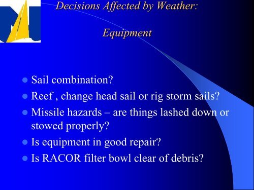
- Page 6 and 7: Decisions Affected by Weather:Navig
- Page 8 and 9: Weather Tools Available On• Barom
- Page 10 and 11: Weather Tools Onboard Navy 44• Ch
- Page 12 and 13: Typical chart receivedonboard a Nav
- Page 15 and 16: Nautical Weather Sayings• Red sky
- Page 17 and 18: Marine Weather Thumb Rules• Pay a
- Page 19 and 20: Marine Weather Thumb Rules• Low a
- Page 21 and 22: Marine Weather Thumb Rules• Chang
- Page 23 and 24: Air Masses• Air masses are vast b
- Page 25 and 26: Can you pick out the5 types of air
- Page 27 and 28: Pressure• The Earth is alwaysthro
- Page 29 and 30: High Pressure• Air circulates aro
- Page 31 and 32: Pressure• Atmospheric pressure is
- Page 33 and 34: Pressure and P`essure Trends• Wat
- Page 35 and 36: Wind and Pressure• Wind is the re
- Page 37 and 38: Wind and Pressure• Weather charts
- Page 39 and 40: The red arrow indicates your boat
- Page 41 and 42: Air Masses and Frontal Systems• W
- Page 43 and 44: Cold Front• Cold Air pushes under
- Page 45 and 46: Cold Front Weather Sequence• Wind
- Page 47 and 48: Cold Front Weather Sequence• As f
- Page 49 and 50: Microburst Sequence
- Page 51 and 52: Warm Front Weather• Cirrus clouds
- Page 53 and 54: Nimbostratus (Ns)Altostratus (As)Ci
- Page 55:
Occluded Front• Occurs when cold
- Page 58 and 59:
Typical chart receivedonboard a Nav
- Page 60 and 61:
Nautical Weather Sayings• Red sky
- Page 62 and 63:
Forecasting weather usingclouds•
- Page 64 and 65:
CloudsAltocumulus Ac(mackerel skies
- Page 66 and 67:
Cloudscumulus Cu (heap)
- Page 68 and 69:
CloudsCumulonimbus Cb
- Page 70 and 71:
CloudsCumulonimbus with waterspout
- Page 72 and 73:
Red Sky at NightSailor’s Delight
- Page 74 and 75:
“Mackerel Skies and Mare’s Tail
- Page 76 and 77:
USN Official Use Only ResourcesNava
- Page 78 and 79:
Location of NOAA Buoys
- Page 80 and 81:
Location of NOAA Buoys
- Page 82:
Location of NOAA Buoys
- Page 86 and 87:
SSB or HF Radio• Voice Broadcasts
- Page 88 and 89:
Wind WarningsGale Warnings: 34 - 47
- Page 90 and 91:
Hurricane Warnings• Definite Clos
- Page 92 and 93:
Hurricanes and Tropical Storms• A
- Page 94 and 95:
Onboard Weather ChartsHF Facsimile
- Page 96 and 97:
Weather Charts• Weather Charts ca
- Page 98 and 99:
Weather Chart Symbols
- Page 100 and 101:
Weather Charts and Symbols• Surfa
- Page 102 and 103:
Deciphering Wind Barbs• Wind barb
- Page 104 and 105:
Deciphering Wind BarbsWhat is the d
- Page 106:
Weather Chart Symbols
- Page 109:
Surface Forecast Charts for 24 hr 4
- Page 112 and 113:
Remember what the bold 564 isoheigh
- Page 114 and 115:
Upper Level Weather Charts• Upper
- Page 116 and 117:
5640 isoheight (bold line) shows th
- Page 118:
Why is Sea State Important?• Beca
- Page 123 and 124:
Remember what the bold 564 isoheigh
- Page 125:
Questions???