Fort Mountain State Park Trail Map - Georgia State Parks and ...
Fort Mountain State Park Trail Map - Georgia State Parks and ...
Fort Mountain State Park Trail Map - Georgia State Parks and ...

Create successful ePaper yourself
Turn your PDF publications into a flip-book with our unique Google optimized e-Paper software.
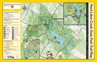
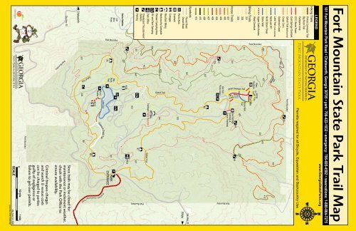
Tower <strong>Trail</strong>SCALE01/2 mile 1 mile<strong>Map</strong> Data Oct. 2008printed Nov. 2010 | 20M-$1860<strong>Park</strong> BoundaryCriminal trespass charges<strong>and</strong> search & rescue costscan be charged to partiesguilty of negligence orfailure to get user permits.<strong>Park</strong> BoundaryGa. Hwy. 52Since trails may be closed formaintenance or inclement weather,check with the <strong>Park</strong> Office toensure availability.Chatsworth301Gahuti <strong>Trail</strong>303301i C o n n ec t o r Tr a i l#2#6-15P PicnicShelter 5i n h o tGoldmineCreek<strong>Trail</strong>Lake <strong>Trail</strong>P#3CliffMineRoad<strong>Park</strong> BoundaryBigRock<strong>Trail</strong>P301PARKENTRANCEPPHorse Stables407#1#1-5Office303P<strong>Park</strong>ing301407301#1Checkpoint "You are Here"markers<strong>Park</strong> Boundary401P<strong>Park</strong> OfficeGahuti <strong>Trail</strong>400Mtn. Bike<strong>Trail</strong>head Permit RequiredRV <strong>and</strong> Tent CampingPioneer Camping AreaBackcountry Campsite408Gahuti <strong>Trail</strong>301<strong>Mountain</strong> BikingCottagesOverlook401Picnic Area302Paved RoadGravel RoadEllijay301Ga. Hwy. 52Symbols412410408407#4407405403404#2P403Old <strong>Fort</strong>Picnic Area401400P<strong>Park</strong> BoundaryHorse <strong>Trail</strong>s301Cool SpringsOverlook &Gahuti <strong>Trail</strong>head303302410302401West Overlook <strong>Trail</strong>CCC Stone#4#5Stone Wall<strong>Trail</strong>Biking <strong>Trail</strong>s301<strong>Park</strong> Boundary<strong>Fort</strong> Mtn.West OverlookWestOverlookTower <strong>Trail</strong>Upper Cabin AccessN. Stone301Stone Wall404407410412North Stone TowerMulti-use 201201401Lake <strong>Trail</strong> (multi-purpose)Goldmine Creek405401Creek Conn.#3Gahuti <strong>Trail</strong> (Backcountry)<strong>Park</strong> BoundaryCool Springs OverlookCCC Stone TowerCampers LoopPermits required for all Bicycle, Equestrian <strong>and</strong> Backcountry UsePinhoti Connector <strong>Trail</strong>Big Rock <strong>Trail</strong>Hiking <strong>Trail</strong>sLEGENDwww.<strong>Georgia</strong><strong>State</strong><strong>Park</strong>s.org181 <strong>Fort</strong> <strong>Mountain</strong> <strong>Park</strong> Road • Chatsworth, <strong>Georgia</strong> 30705 • park: 706-422-1932 • emergency: 706-695-4592 • reservations: 1-800-864-7275<strong>Fort</strong> <strong>Mountain</strong> <strong>State</strong> <strong>Park</strong> <strong>Trail</strong> <strong>Map</strong>
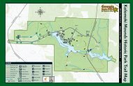
Accessibility for selected trailsCombination <strong>Trail</strong>s: made by combining trails shown on the map.Mystery of <strong>Fort</strong> <strong>Mountain</strong>High atop <strong>Fort</strong> <strong>Mountain</strong> are the rocky ruins of an ancient “stonewall” with prehistoric origin steeped in legend. Generations ofarchaeologists <strong>and</strong> historians have unsuccessfully sought to unravelthe riddle of this wall, one of several stone assemblages scatteredthroughout the Southeast. More than 150 years after its discovery,answers still evade us as to who built the wall, when <strong>and</strong> for whatpurpose.Theories abound, <strong>and</strong> one of the more realistic explanations is thatthe wall was built around 500 A.D. by a tribe of Native Americansfor ceremonial or religious purposes. Others assert the wall was builtby w<strong>and</strong>ering b<strong>and</strong>s of Welsh explorers during the 14th century asfortification against Indians. Welsh Prince Madoc has been creditedwith building several stone petroglyphs in the Southeast aftersupposedly sailing into Alabama. Another theory, based on Cherokeelegend, is that the wall was built by the “Moon Eyes,” a race of lightskinnedpeople who could see in the dark because of their larger orpaler eyes. Or perhaps Spanish conquistadors, possibly Hernado deSoto, built the wall as a defense against Indian attacks.Since no artifacts have been found to support these theories, no oneknows who built the “wall of stones” zigzagging across the southernface of the Cohutta mountain range’s most prominent peak. This partof the southern Appalachian <strong>Mountain</strong>s rises above the PiedmontPlain <strong>and</strong> offers 80-mile views, making it an ideal location forceremonial practices or defensive needs.The stone wall runs east <strong>and</strong> west for 855 feet, <strong>and</strong> its height variesfrom two to six feet. Archaeologists believe it was much higher beforeexploration <strong>and</strong> plunder by previous scientists <strong>and</strong> treasure hunters.Adding to the mystery are 30 “pits” built into the wall. Were thesegun emplacements or symbolic to some ceremonial practice of earlierinhabitants? Will the secrets contained within these stones foreverremain a mystery?<strong>Trail</strong> Safety & Etiquette• Tell someone your itinerary <strong>and</strong> expected return time.• Be prepared for unexpected weather changes by dressing inlayers <strong>and</strong> carrying rain gear.• Take a map, water, snacks, first aid kit, flashlight <strong>and</strong> whistle.Three short blasts on a whistle are known as a call for help.• Do not stray from trails. If you become lost, stay in onelocation <strong>and</strong> wait for help. This will make it easier for rescuersto find you.• Pack out all trash.• Keep pets on a leash.• Do not pick flowers or disturb wildlife.• Protect the l<strong>and</strong>scape by staying on trails.<strong>Mountain</strong> Biking Safety & Etiquette• Wear a helmet.• Bikers yield to hikers <strong>and</strong> horses.• Announce your presence to others. When passing, a polite“On your left” or “On your right” is suggested.• Carry maintenance tools <strong>and</strong> replacement inner tubes.• Prevent erosion by staying on trails <strong>and</strong> not skidding.235023002250220021502100 feet above sea level clockwise0.5-Mile LoopAvg. Travel Time: 1 HourFoot Travel Only.Compacted Natural Soil SurfaceAvg. Grade: 14%; Max: 30%/200LFMin. Width: 30 InchesAvg. X-slope: 12%; Max: 30%/20LFCool Springs Overlook <strong>Trail</strong> 100% accessible by 2002 st<strong>and</strong>ards.260025002400230022002100 feet above sea level clockwise0 1 2 3 4 5 6 7 8290028502800275027002650Gahuti <strong>Trail</strong>(Backcountry)8.2 Mile LoopAvg. Travel Time: 5 HoursFoot Travel Only.Compacted Natural Soil SurfaceAvg. Grade: 10%; Max: 25%/500LFMin. Width: 18 InchesAvg. X-slope: 12%; Max: 30%/50LFCamping by Permit Only.Big Rock <strong>Trail</strong>Lake <strong>Trail</strong>The Big Rock Nature <strong>Trail</strong>travels from the ridgeline nearthe lake down into a mountainhollow, then crosses a dividingridge <strong>and</strong> returns up GoldMine Creek passing severalsmall cascades <strong>and</strong> waterfalls.Wildflowers abound in spring.The Gahuti <strong>Trail</strong> travels aroundthe edge of the park, passingjust below the summits of bothCohutta <strong>and</strong> <strong>Fort</strong> mountains.Ever changing, the trail is bothbeautiful <strong>and</strong> challenging in allseasons. Hikers should alwaysbe aware of changing weather.Four backcountry campsitesare available for use by permit.feet above sea level clockwise1.2-Mile LoopAvg. Travel Time: 1 HourOpen to Biking & Foot Travel.Starts <strong>and</strong> ends at picnic shelter #5Compacted Natural Soil SurfaceAvg. Grade: 4%; Max: 20%/75LFMin. Width: 30 InchesAvg. X-slope: 12%; Max: 25%/60LFBikers must yield to all other users.The Lake <strong>Trail</strong> loops around<strong>Fort</strong> <strong>Mountain</strong>’s lake <strong>and</strong>can be accessed from thecampgrounds, cottage areas,picnic area <strong>and</strong> picnic shelter#5, <strong>and</strong> the Big Rock <strong>Trail</strong>parking area. <strong>Trail</strong> is mostaccessible traveled clockwise.In this manner, users descendthe 75 lineal feet 20% grade.Stone Tower Combo:West Overlook, CCC Stone Tower290028502800275027002650 feet above sea level clockwise0.9-Mile LoopAvg. Travel Time: 1 HourFoot Travel Only.Compacted Natural Soil SurfaceAvg. Grade: 14%; Max: 20%/250LFMin. Width: 36 InchesAvg. X-slope: 12%; Max: 15%/45LFStone Steps on East Part of Loop2650260025502500245024000feet above sea level1.6-Mile Combination LoopAvg. Travel Time: 1 1/4 HoursFoot Travel Only.Compacted Natural Soil SurfaceAvg. Grade: 10%; Max: 25%/150LFMin. Width: 18 InchesAvg. X-slope: 12%; Max: 25%/25LFBeware of bikes on Lake <strong>Trail</strong>The Upper Cabin Loop is hikedby using the Upper Cabin Access<strong>Trail</strong> to the Lake <strong>Trail</strong>, proceedingThe Stone Tower Loop is hikedby traveling uphill on the WestOverlook <strong>Trail</strong> <strong>and</strong> returningon the CCC Stone Tower <strong>Trail</strong>.Year-round vistas from WestOverlook.Upper Cabin Combo:Upper Cabin Access, Lake <strong>Trail</strong>, Goldmine Creek, Gahuti1clockwiseto the Goldmine Creek <strong>Trail</strong> <strong>and</strong>returning on the Gahuti <strong>Trail</strong> tothe upper cottage area.This combination of trails offersexcellent vistas from the upperlevels of the ridgeline <strong>and</strong>wonderful views of the lake <strong>and</strong>Goldmine Creek. The creek wasnamed for early goldmining,with some of the old mining pitsvisible along the trail.CLIMATE DATA FOR CHATSWORTH, GEORGIAAvg. Avg. Avg.Month High Low Mean Precip. Record High Record LowJan 49ºF 30ºF 39ºF 5.86 in 79ºF (1949) -10ºF (1985)Feb 54ºF 32ºF 43ºF 4.93 in 79ºF (1989) 0ºF (1966)Mar 63ºF 40ºF 51ºF 6.34 in 87ºF (2000) 7ºF (1993)Apr 72ºF 47ºF 59ºF 4.30 in 91ºF (2002) 25ºF (1987)May 79ºF 56ºF 68ºF 4.28 in 95ºF (1962) 33ºF (1971)Jun 86ºF 65ºF 75ºF 4.38 in 103ºF (1988) 42ºF (1984)Jul 89ºF 69ºF 79ºF 4.76 in 103ºF (1952) 52ºF (1967)Aug 89ºF 68ºF 78ºF 3.65 in 103ºF (1983) 51ºF (1968)Sep 83ºF 62ºF 72ºF 5.00 in 102ºF (1954) 32ºF (1967)Oct 73ºF 49ºF 69ºF 3.31 in 94ºF (1954) 23ºF (1952)Nov 62ºF 40ºF 51ºF 4.79 in 86ºF (1961) 12ºF (1955)Dec 53ºF 33ºF 43ºF 4.92 in 78ºF (1956) -4ºF (1983)260024002200200018001600 feet above sea level0 214.6-Mile LoopAvg. Travel Time: 4 Hours/BikeOpen to Biking & Foot TravelCompacted Natural Soil SurfaceAvg. Grade: 10%; Max: 25%/1330LF20% Ascending in last 3 milesMin. Width: 48 InchesAvg. X-slope: 12%; Max: 20%/50LFHikers Yield To Bicyclists.<strong>Trail</strong> Closed to Horses.GradeX-slopeWidth4301 Biking <strong>Trail</strong>68clockwise10 12The East-West Bike Loop israted by many as one of themost beautiful <strong>and</strong> challengingbike trails in the southeasternUnited <strong>State</strong>s. Users travel frommountain ridge top to valley floor,through pine <strong>and</strong> scrub laurelthickets, upl<strong>and</strong> hardwood <strong>and</strong>cove forests, by old mines, thenwaterfalls <strong>and</strong> rhododendronsalong Hassler’s Mill Creek beforereturning up the mountain.All trail profiles start <strong>and</strong> end at their trailheads unless otherwise indicated.Obstacles may include uneven surfaces, exposedrock <strong>and</strong> tree roots, fallen trees <strong>and</strong>/or limbs, steps,long steep grades, loose stones <strong>and</strong> leaf litter,softness, mud, icing, or other slick conditions whenwet, poisonous plants, heat or cold in season,insects, snakes, <strong>and</strong> wild animals including bears.Horse <strong>Trail</strong>sMore than 25 miles of horse trails offer loop rides varying from3 to 16 miles. Riders must bring their own horses <strong>and</strong> register atthe stables; or can rent guided horses from the concessionaire.First-time riders must attach a photocopy proof of a negativeCoggins test. <strong>Park</strong>ing is at the stables access (west side of thepark). Check the website or call ahead for trail closings duringbad weather.The horse trails pass through varied environments, from lushforest coves to wind-swept ridge tops. Wildflowers catch theeye in early spring, green foliage is bountiful during summer,changing leaf colors welcome fall, <strong>and</strong> spectacular vistas arrivewith winter. Cliffs, waterfalls, old mines (some that providenatural “air-conditioning” during summer <strong>and</strong> warm air duringwinter), <strong>and</strong> ab<strong>and</strong>oned mining equipment add interest tothe trails. Horse watering stations are at approximately twomileintervals.The shorter loops, which begin at the stables <strong>and</strong> go pastwaterfalls, are the easier trails, with most at a 20% or less grade.Basic rules apply: riders must stay on marked trails; no trailriding between sunset <strong>and</strong> sunrise; no reckless or fast riding; <strong>and</strong>horses should not be left unattended or unbridled. Anyonefound in violation of these rules will face criminal prosecution(OCGA 12-3-10) <strong>and</strong> be banned from use of horse trails atall state parks.