Hard Labor Creek State Park Trail Map - Georgia State Parks and ...
Hard Labor Creek State Park Trail Map - Georgia State Parks and ...
Hard Labor Creek State Park Trail Map - Georgia State Parks and ...

You also want an ePaper? Increase the reach of your titles
YUMPU automatically turns print PDFs into web optimized ePapers that Google loves.
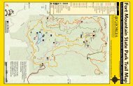
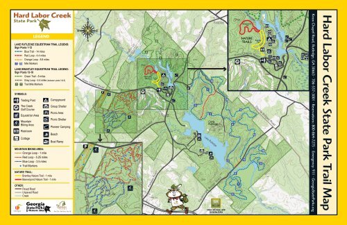
LEGENDLAKE RUTLEDGE EQUESTRIAN TRAIL LEGEND:Sign Posts 1-12Blue <strong>Trail</strong> - 14 milesRed Loop - 4.4 milesOrange Loop - 8.8 miles1 - 15 Mile MarkersLAKE BRANTLEY EQUESTRIAN TRAIL LEGEND:Sign Posts 13-18Green <strong>Trail</strong> - 8 milesGray Loop - 4.4 miles (between posts 3 & 6)1 - 7 <strong>Trail</strong> Mile MarkersSYMBOLS:Trading PostThe <strong>Creek</strong>Golf CourseEquestrian AreaMountainBiking AreaRestroomCottageMOUNTAIN BIKING AREA:Orange Loop - 1 mileRed Loop - 5.25 milesBlue Loop - 3.5 miles<strong>Trail</strong> MarkersNATURE TRAIL:Brantley Nature <strong>Trail</strong> - 1 mileBeaverpond Nature <strong>Trail</strong> - 1 mileOTHER:Paved RoadUnpaved Road<strong>Creek</strong>CampgroundGroup ShelterPicnic AreaPicnic ShelterPioneer CampingBeachBoat RampPARK BOUNDARYKnox Chapel RoadPARK BOUNDARY NDARYPForestSe viceRoadice RoadSe r v278 12<strong>Hard</strong><strong>Labor</strong><strong>Creek</strong>RutledgeWalton Co.Morgan Co.45Beaverpond<strong>Trail</strong>NATURETRAILSOld Mill Road6Brantley<strong>Trail</strong>Fairplay Road3PARK BOUNDARY PARK BOUNDARY2Lake Brantley71<strong>Hard</strong><strong>Labor</strong>PARK BOUNDARY<strong>Creek</strong>2Fairplay Road1315CampRutledgeLake RutledgeFairplayFambrough Bridge RoadFREE MOBILE APPDOWNLOAD14546Knox Chapel Road871311<strong>Hard</strong> <strong>Labor</strong> <strong>Creek</strong>Beaverpond<strong>Trail</strong>NATURETRAILS12Brantley<strong>Trail</strong>Double Bridges Road9<strong>Hard</strong>10<strong>Labor</strong>PARK BOUNDARY<strong>Creek</strong>Lake BrantleyFairplay Road<strong>Hard</strong> <strong>Labor</strong> <strong>Creek</strong>Knox Chapel Road, Rutledge, GA 30663 • 706-557-3001 • Reservations: 800-864-7275 • Emergency: 911 • <strong>Georgia</strong><strong>State</strong><strong>Park</strong>s.org<strong>Hard</strong> <strong>Labor</strong> <strong>Creek</strong> <strong>State</strong> <strong>Park</strong> <strong>Trail</strong> <strong>Map</strong>
<strong>Hard</strong> <strong>Labor</strong> <strong>Creek</strong> <strong>State</strong> <strong>Park</strong>, located in Morgan <strong>and</strong>Walton counties, is one of the largest state parks in<strong>Georgia</strong>. The park’s unusual name is derived from abold stream that cuts an easterly course through thepark <strong>and</strong> joins the Apalachee River 25 miles away. Thepark came into being during the Great Depressionwhen the National <strong>Park</strong> Service acquired 44 parcelsof l<strong>and</strong>, joining them to form the 5,804-acre <strong>Hard</strong><strong>Labor</strong> <strong>Creek</strong> Recreational Demonstration Area. Thesite’s purpose was to demonstrate the reclamationof marginal farml<strong>and</strong> for recreation. The task of l<strong>and</strong>stabilization, along with early facility construction, wascompleted by the Civilian Conservation Corps <strong>and</strong>the Work Progress Administration. Beginning in 1934,these industrious workers planted thous<strong>and</strong>s of trees,built dikes <strong>and</strong> terraces, constructed roads <strong>and</strong> clearedlakebeds. In 1946, the Recreation Demonstration Areawas given to the <strong>State</strong> of <strong>Georgia</strong> <strong>and</strong> became knownas <strong>Hard</strong> <strong>Labor</strong> <strong>Creek</strong> <strong>State</strong> <strong>Park</strong>.Rules for Stable Use <strong>and</strong> Equestrian <strong>Trail</strong>s:• Present a negative equine infectious anemia test foreach horse.• Ride only during daylight, between dawn <strong>and</strong>sunset.• Do not ride on roadways or any other area that isnot clearly identified for equestrians.• Do not ride in a fast or reckless manner.• Attend horses at all times.• Ride no more than 2 abreast on trails.• Do not graze horses.• Camp only in the designated campground.• Do not ride horses into the campground.• Do not picnic in the campground.• Do not stable horses using a tie-line or temporarycorral.• Do not put more than one horse in each stall.• Dogs must be leashed <strong>and</strong> attended at all times.• Only registered overnight park visitors may stablehorses.• Return stall key(s) to the park office by 1 p.m. onthe day of departure.• Remove soiled bedding from stall(s) prior todeparting.• Do not consume alcoholic beverages in day-useareas.• No smoking in the stable area.BRANTLEY TRAIL NATURE <strong>Trail</strong>850800750700650600BEAVERPOND NATURE <strong>Trail</strong>8508007507006506000 1MilesBrantley <strong>Trail</strong> - 1 mile, Compacted Soil Surface, EASY TO MODERATEAn easy walk characterized by mature hardwoods, this trail hasreminders of the park’s origin. A prominent ravine echoes thepast <strong>and</strong> the result of poor l<strong>and</strong>-use practices. Much of the l<strong>and</strong>which comprises <strong>Hard</strong> <strong>Labor</strong> <strong>Creek</strong> <strong>State</strong> <strong>Park</strong> was eroded cotton<strong>and</strong> corn fields <strong>and</strong> only marginally productive. Originally knownas <strong>Hard</strong> <strong>Labor</strong> <strong>Creek</strong> National Recreation Demonstration Area,l<strong>and</strong> stabilization was one of the first projects accomplished in the1930s by the Civilian Conservation Corps.BEAVERPOND TRAIL0 1MilesBeaverpond <strong>Trail</strong> - 1 mile, Compacted Soil Surface, EASY TO MODERATEBe sure you do not miss the tulip poplar (liriodendron tulipiferaL) found on the left not long on your hike. Using care, step to itsbase <strong>and</strong> gain a greater appreciation of its size. Another featureof importance are the wetl<strong>and</strong>s. These cradles of life contain therequired food, shelter, <strong>and</strong> water for organisms across the entirefood chain.MOUNTAIN BIKE TRAIL AREAThere are 10 miles of mountain trails appropriate for the beginner to advanced experience level mountainbiking. The Orange Loop is about 1-mile on level ground which takes the rider through an interesting areaof regenerating pine forest. The Red Loop is a more challenging 5.25-mile loop that will take the rider up<strong>and</strong> down gently sloping terrain, <strong>and</strong> crosses older hardwood forest of mixed pine <strong>and</strong> hardwood st<strong>and</strong>s.Along the way are lush fern covered stream bottoms, boulder formations, <strong>and</strong> cascading streams. This trail israted more for the Intermediate/Advanced riders. The Blue Loop is the newest bike trail that is a 3.5-mileloop rated for Beginner/Intermediate riders <strong>and</strong> highlights four creekside excursions. Joining the <strong>Park</strong>ingLot <strong>and</strong> the Orange <strong>Trail</strong> to the Red <strong>and</strong> Blue <strong>Trail</strong>s is the Purple Connector <strong>Trail</strong>, a .5-mile, bi-directionalBeginner level trail featuring a gentle climb <strong>and</strong> ascent through a spacious hardwood st<strong>and</strong>. Riders may alsoenjoy seeing wildlife like deer, turkey, <strong>and</strong> possibly fox squirrels as they enjoy a day of biking.EQUESTRIAN AREAThe equestrian area features trails of various lengths upto 22 miles. A gated entrance allows secured access. Inaddition to the trails this area includes paved parking,campsites with water <strong>and</strong> electricity, a bathroom withhot showers, <strong>and</strong> a large riding ring. A negative equineinfectious anemia test must be presented prior to ridingany state park trail.Lake Rutledge Equestrian <strong>Trail</strong>This 14-mile trail features both mature hardwood<strong>and</strong> hardwood/pine forests. Most striking are thebottoms <strong>and</strong> the creeks that course through them.Often one feels relocated to a more mountainoussetting. Short climbs of moderate difficulty arecommon throughout the trail. Four return loopscan be used to measure a ride’s length <strong>and</strong> duration.The section of trail across Fambrough Bridge Roadis used less often <strong>and</strong> offers a ride of quiet solitude.The Lake Rutledge equestrian trail is open to hikers(see etiquette).Lake Brantley Equestrian <strong>Trail</strong>This 8-mile trail has both pine <strong>and</strong> hardwood forests.Deep gorges <strong>and</strong> granite outcroppings are common.A rock quarry used by the Civilian ConservationCorps can be seen if you are especially observant.For a shorter ride take the gray loop <strong>and</strong> cut thedistance in half. Use caution crossing Fairplay Roadby dismounting.The Lake Brantleyequestrian trailis open to hikers(see etiquette).SAFETY TIPS• Tell someone your itinerary <strong>and</strong> expectedreturn time.• Take a map, water, snacks, first aid kit, flashlight<strong>and</strong> whistle. Three short blasts on a whistle areknown as a call for help.• Do not stray from trails. If you become lost, stayin one location <strong>and</strong> wait for help. This will makeit easier for rescuers to find you.• Don’t count on cell phones to work in remoteareas, but if they do, be able to give detailsabout your location.• Invest in good hiking socks such as those foundat sporting goods stores. Avoid blisters bycarrying “moleskin” <strong>and</strong> applying it as soon asyou feel hot spots on your feet.• Be prepared for unexpected rain <strong>and</strong> windwhich can lead to hypothermia. Always carryquality rain gear <strong>and</strong> turn back in bad weather.If you become wet or cold, it is important toget dry <strong>and</strong> warm as quickly as possible.• Dress in layers <strong>and</strong> avoid cotton.ETIQUETTE• Pack out all trash.• Keep dogs on a leash at all times.• Do not pick flowers, disturb wildlife or takeanything off the park.• Protect the park <strong>and</strong> help prevent erosion bystaying on the trails.• Give the right-of-way to equestrians. Do notmake loud noises or hurried movements aroundhorses.TICKSThese arthropods feed on warm-blooded animals.They do not fly or jump; they come in contact withus or our pets when we walk in tall grass or brush. It ispossible to contract diseases such as Rocky MountainSpotted Fever or Lyme Disease if an infected tickstays attached for a long period of time. Use insectrepellant <strong>and</strong> always check yourself <strong>and</strong> your pet aftereach hike. Ticks should be removed with tweezers.Avoid crushing the tick. Nail polish, hot matches, orkerosene will NOT make a tick let go. If you developa fever or rash within 2 to 3 weeks after a tick bite,see your physician.printed on recycled paper20,000 / $1760 - July 2013