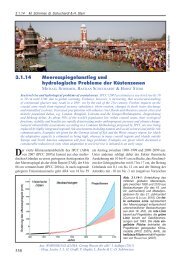
High-resolution wave climate analysis in the Helgoland area - GKSS
High-resolution wave climate analysis in the Helgoland area - GKSS
High-resolution wave climate analysis in the Helgoland area - GKSS

You also want an ePaper? Increase the reach of your titles
YUMPU automatically turns print PDFs into web optimized ePapers that Google loves.
2.3 Added value for <strong>the</strong> small-scale <strong>wave</strong> simulation <strong>in</strong> terms of extremes 19<br />
Figure 2.8: Quantile-quantile plots of HF and KMH simulated significant <strong>wave</strong> height <strong>in</strong> meters<br />
for <strong>the</strong> period 1990-2001 at po<strong>in</strong>ts a) DWP b) LNA c) HH1 d) HH2 e) DE1 f) DE2.<br />
eastwards of <strong>Helgoland</strong> <strong>the</strong> 99-percentile of significant <strong>wave</strong> height is about one meter higher<br />
compared to <strong>the</strong> HF simulation. Fur<strong>the</strong>rmore, for <strong>the</strong> K-model run, small scale features<br />
of <strong>the</strong> bathymetry are visible <strong>in</strong> <strong>the</strong> distribution of <strong>the</strong> <strong>wave</strong> extremes. While large-scale<br />
features of extreme <strong>wave</strong> statistics are quite similar <strong>in</strong> both simulations, <strong>the</strong> small scale<br />
differences may be significant for coastal protection. Figure 2.8 shows a comparison of <strong>the</strong><br />
frequency distribution for significant <strong>wave</strong> heights near different coastal facilities obta<strong>in</strong>ed<br />
from <strong>the</strong> HF and <strong>the</strong> KMH h<strong>in</strong>dcasts. The positions of <strong>the</strong> analyzed po<strong>in</strong>ts can be <strong>in</strong>ferred<br />
from Figure 2.1. Although <strong>the</strong> K-model is driven with boundary conditions from <strong>the</strong> HF<br />
run and both simulations utilize <strong>the</strong> same w<strong>in</strong>d forc<strong>in</strong>g, differences <strong>in</strong> <strong>the</strong> frequency distributions,<br />
<strong>in</strong> particular for near coastal locations, do emerge. The details of <strong>the</strong>se differences<br />
depend on <strong>the</strong> location. At DWP both h<strong>in</strong>dcasts are ra<strong>the</strong>r similar. Here water depth is<br />
about 20 meters and <strong>the</strong> shadow<strong>in</strong>g effect of <strong>the</strong> island plays a m<strong>in</strong>or role as <strong>the</strong> prevail<strong>in</strong>g<br />
w<strong>in</strong>d and <strong>wave</strong> directions are from <strong>the</strong> southwest to <strong>the</strong> northwest. At LNA <strong>the</strong> situation is<br />
different. LNA is also located at <strong>the</strong> western side of <strong>the</strong> island, but here bathymetry effects<br />
become important. While <strong>the</strong> lower 75% of <strong>the</strong> simulated <strong>wave</strong> height distributions are still<br />
ra<strong>the</strong>r similar <strong>in</strong> <strong>the</strong> HF and <strong>the</strong> KMH, <strong>the</strong> uppermost 20% are remarkably higher <strong>in</strong> <strong>the</strong><br />
K-model simulation (Fig. 2.8b), demonstrat<strong>in</strong>g <strong>the</strong> results of shoal<strong>in</strong>g 1 for <strong>the</strong> KMH <strong>wave</strong>s.<br />
1 Shoal<strong>in</strong>g occurs when <strong>the</strong> <strong>wave</strong>s enter shallow water. The <strong>wave</strong> speed and <strong>wave</strong> length decrease,