

Wills Creek Watershed - Crossroads RC&D
Wills Creek Watershed - Crossroads RC&D
Wills Creek Watershed - Crossroads RC&D

Create successful ePaper yourself
Turn your PDF publications into a flip-book with our unique Google optimized e-Paper software.
L A N D U S E I N T H E W I L L S C R E E K W A T E R S H E D<br />
AGRICULTURAL<br />
Agriculture in the <strong>Wills</strong> <strong>Creek</strong> <strong>Watershed</strong> not only<br />
Land<br />
is a very visible activity, it’s also big business.<strong>Wills</strong><br />
<strong>Creek</strong> <strong>Watershed</strong> contains about 166,000 acres of<br />
agricultural land, which accounts for 39 percent of<br />
the land use. Hay and cattle make up the main<br />
agricultural products. Maintaining a healthy<br />
environment is critical to maintaining a healthy<br />
agricultural industry; that is why farmers were<br />
among the first conservationists in the area.<br />
Agriculture in the<br />
<strong>Wills</strong> <strong>Creek</strong> <strong>Watershed</strong><br />
Although declining in recent years, the agricultural industry has<br />
been important in the history of the watershed, and still<br />
encompasses 39 percent of the land use. Since the time the forests<br />
were cleared for agricultural purposes in the early 1800s, much of<br />
the area remains in agricultural production today. After extensive<br />
strip mined areas were reclaimed, much of the land was planted to<br />
grass to prevent soil erosion.This is now being used as pasture or<br />
hay for beef cattle.The average size farm in the watershed is 184<br />
acres. Hay and corn for grain are the predominant crops grown.<br />
The predominate livestock industry is beef cattle.<br />
Since the first settlers arrived in <strong>Wills</strong><br />
<strong>Creek</strong>, their survival was dependent<br />
on what could be produced off the<br />
land. This dependency was based on<br />
the soil’s ability to produce enough<br />
food. In the early days small farms fed<br />
individual families. Today with the<br />
mechanization of modern farm<br />
SC:NRCS<br />
equipment, farms have grown and now<br />
feed many, many people. The average size of a farm has increased<br />
from 99 acres in 1924 to 184 acres in 1996.<br />
The agricultural industry has declined within the <strong>Wills</strong> <strong>Creek</strong><br />
<strong>Watershed</strong>.There are fewer acres in pasture land (198,956 in 1924)<br />
and fewer crop acres planted (118,667 in 1924).<br />
26<br />
LIVESTOCK PRODUCTION<br />
ANIMAL NUMBER<br />
Beef cattle/calves 50,000<br />
Dairy Cows 2,400<br />
Hogs 8,000<br />
Sheep/Lambs 2,600<br />
Agriculture in <strong>Wills</strong> <strong>Creek</strong> Today<br />
Livestock is the major agricultural industry in the<br />
region with pasture land encompassing 91,686 acres,<br />
some of which has been strip mined and reclaimed.<br />
Hay and corn are the predominant crops grown in the<br />
watershed with cropland encompassing 74,222 acres.<br />
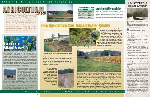
How Agriculture Can Impact Water Quality<br />
NRCS<br />
Manure Storage allows for proper handling of waste.<br />
Confined livestock operations can produce a large<br />
amount of animal waste. This waste must be<br />
dispersed in a proper way, over the appropriate<br />
number of acres, so that plants can absorb the<br />
nutrients in the material and excess nutrients do<br />
not enter into the stream.<br />
Proper handling,<br />
application, and<br />
disposal of agricultural<br />
chemicals and fertilizers<br />
are vital to the health<br />
of our watershed<br />
community. Water that<br />
runs off the land carries<br />
these excess materials<br />
and can pollute the<br />
rivers, lakes, and<br />
streams.<br />
NRCS<br />
NRCS<br />
SC<br />
Gully erosion washes away<br />
precious topsoil.<br />
Pond covered with algae<br />
Allowing livestock to graze in woodlands<br />
increases soil erosion. Grazing animals<br />
along riparian corridors destabilizes<br />
the streambank, which causes soil<br />
erosion and reduces the quality of<br />
the riparian corridor. In addition,<br />
animal waste can directly enter<br />
streams. This increases the nutrient<br />
levels in the water and alters the habitat<br />
by increasing algae and other plant life.<br />
This decreases the dissolved oxygen<br />
available for aquatic life.<br />
Growing crops on highly erodible land increases the potential for soil erosion.<br />
Erosion not only reduces the ability to raise crops in the future, but it<br />
produces sediment in suspension throughout the watershed ecosystem.<br />
Turbidity in the water influences plant and animal life by not allowing sunlight<br />
to penetrate and putting a coating of soil particles along the substrate.<br />
Within <strong>Wills</strong> <strong>Creek</strong> <strong>Watershed</strong> 74,222 acres are planted in cropland. Of these<br />
acres, 16,000 acres are located within soil units classified as highly erodible.<br />
The current erosion rate in the <strong>Wills</strong> <strong>Creek</strong> <strong>Watershed</strong> is 5.8 tons of soil loss<br />
per year.This translates into a total annual soil loss of 151,000 tons! Most of<br />
the soil lost is topsoil, the most productive and fertile part of the soil.<br />
W I L L S C R E E K . . . O U R B A C K Y A R D W A T E R S H E D<br />
27<br />
NRCS<br />
A HISTORICAL<br />
PERSPECTIVE<br />
NRCS<br />
Dust Bowl Timeline (1931-34)<br />
1931:<br />
Drought strikes the Midwestern and Southern plains.<br />
Over plowed and overgrazed fields were starting to lose<br />
their precious topsoil to the wind.<br />
1932:<br />
There are 14 dust storms reported at year’s end.<br />
1933:<br />
· March: Franklin Roosevelt starts his first term.<br />
· March: Soil Conservation Service is created by<br />
President Roosevelt.<br />
· April 14: The worst black blizzard in U.S. History, is<br />
coined Black Sunday.<br />
· April 15: Dust Bowl is named the day after Black<br />
Sunday.<br />
· April 27: Hugh Hammond Bennett (Father of Soil<br />
and Water Conservation), sways the Congress into<br />
declaring Soil erosion a national menace. Outside the<br />
Congressional hearing is a dust storm.<br />
· May: Farmers lose a year’s worth of crops and face<br />
foreclosures.<br />
· September: With hunger and displaced families on<br />
the rise, the Federal Surplus Relief Corporation is<br />
formed, which distributes apples, meat, beans, flour and<br />
cotton.<br />
· There are 38 dust storms by year’s end, children in the<br />
Midwest scurry to school with moistened cloths clutched<br />
to their noses.<br />
1934:<br />
· May: Drought reaches historical proportions,27 states<br />
are severely affected, and it consumes more than 75<br />
percent of the country.<br />
· June: Many more farmers are facing failed crops, the<br />
Frazier-Lemke Farm Bankruptcy Act is passed to restrict<br />
the ability of banks to dispossess farmers in times of<br />
distress.<br />
· In the “Yearbook of Agriculture” for 1934 it stated,<br />
“Approximately 35 million acres of formerly cultivated<br />
land have essentially been destroyed for crop<br />
production...100 million acres now in crops lose all or<br />
most of the topsoil;125 million acres of land now in crops<br />
is rapidly losing topsoil…”<br />
· The first great dust storm kicks up in the Great Plains,<br />
and sends dust to the nation’s capital where the sun is<br />
blotted out, drives grit into the teeth of New Yorkers<br />
and scatters dust on the decks of ships 300 miles out<br />
to sea.