

Wills Creek Watershed - Crossroads RC&D
Wills Creek Watershed - Crossroads RC&D
Wills Creek Watershed - Crossroads RC&D

Create successful ePaper yourself
Turn your PDF publications into a flip-book with our unique Google optimized e-Paper software.
W I L L S C R E E K W A T E R S H E D<br />
WHAT ISa <strong>Watershed</strong> ?<br />
WHAT ISa<br />
<strong>Watershed</strong> ?<br />
Everyone lives in a watershed. A watershed is an area of land in which all the water drains down to a common outlet.<br />
All the land in the <strong>Wills</strong> <strong>Creek</strong> <strong>Watershed</strong> drains to <strong>Wills</strong> <strong>Creek</strong>. As the water moves down the slopes and across<br />
the surfaces, it is influenced by the land and how we use it. It travels across forests, farms, suburban lawns and city<br />
streets through streams, lakes and wetlands as surface water, or it seeps into the soil and moves as groundwater.<br />
A watershed does not acknowledge political boundaries and includes all living things within its boundaries as<br />
members of its community. Every living thing in the <strong>Wills</strong> <strong>Creek</strong> <strong>Watershed</strong> is part of the same watershed community.<br />
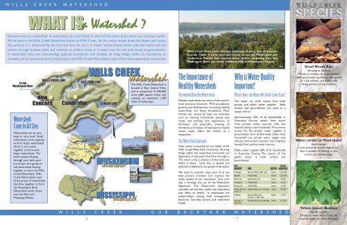
To the<br />
Muskingum River<br />
<strong>Watershed</strong>s<br />
Come In All Sizes<br />
<strong>Watershed</strong>s can be very<br />
large or very small. Small<br />
watersheds come together<br />
to form larger watersheds<br />
which in turn come<br />
together to form even<br />
larger watersheds. The<br />
small streams flowing<br />
through your back yard<br />
are all part of a group of<br />
sub-watersheds flowing<br />
together to form the <strong>Wills</strong><br />
<strong>Creek</strong> <strong>Watershed</strong>. <strong>Wills</strong><br />
<strong>Creek</strong> <strong>Watershed</strong> is part<br />
of the group of watersheds<br />
that flow together to form<br />
the Muskingum River<br />
<strong>Watershed</strong>, which drains<br />
into the Ohio and<br />
Mississippi Rivers.<br />
6<br />
WILLS CREEK<br />
MUSKINGUM<br />
<strong>Watershed</strong><br />
MISSISSIPPI<br />
<strong>Watershed</strong><br />
<strong>Watershed</strong> The Importance of<br />
<strong>Watershed</strong><br />
The <strong>Wills</strong> <strong>Creek</strong> <strong>Watershed</strong> is<br />
located in East Central Ohio<br />
and is comprised of 436,600<br />
acres (682 square miles) and<br />
contains an estimated 1,390<br />
miles of waterways.<br />
VS:GSWCD<br />
NRCS<br />
<strong>Wills</strong> <strong>Creek</strong> flows north through Guernsey County into Coshocton<br />
County. There it turns west and moves across the Muskingum and<br />
Coshocton County line several times before emptying into the<br />
Muskingum River just north of Adams Mills in Muskingum County.<br />
Healthy <strong>Watershed</strong>s<br />
Threatened Healthy <strong>Watershed</strong>s<br />
Healthy watersheds are some of the nation’s<br />
most precious resources. With populations<br />
growing and development increasing, healthy<br />
watersheds are being threatened. Most<br />
threats are caused by land use. Activities<br />
such as clearing forestlands, paving new<br />
roads and parking lots, application of<br />
fertilizers and pesticides, plowing of<br />
farmlands, and release of improperly treated<br />
waste water affect the health of a<br />
watershed.<br />
The <strong>Watershed</strong> Approach<br />
Clean water is essential for the health of the<br />
<strong>Wills</strong> <strong>Creek</strong> <strong>Watershed</strong> community. All living<br />
things within the watershed community are<br />
dependent on the water that flows through it.<br />
The water is like a memory of the land over<br />
which it flows. Land that is abused and<br />
polluted is reflected in the quality of the water.<br />
We need to consider ways each of us can<br />
help protect, maintain and improve the<br />
water quality of our watershed. One such<br />
way is through the use of the <strong>Watershed</strong><br />
Approach. The <strong>Watershed</strong> Approach<br />
considers all activities within the watershed<br />
that affect its health. It emphasizes the<br />
relationships among land management<br />
decisions, everyday actions and watershed<br />
health.<br />
Why is Water Quality<br />
Important?<br />
Where Does the Water We Drink Come From?<br />
The water we drink comes from both<br />
private and public water supplies. Both<br />
surface and groundwater are used as a<br />
supply source.<br />
Approximately 32% of all households in<br />
Guernsey County obtain their water<br />
from private water sources with the<br />
majority being rural households.The primary<br />
source for the private water supplies is<br />
groundwater from drilled wells. Other than<br />
household use, private water supply uses<br />
include commercial, livestock and irrigation<br />
mostly from surface water sources.<br />
Public water supplies 68% of all households<br />
in Guernsey County. The source of the<br />
public water is both surface and<br />
groundwater.<br />
PUBLIC AVG USAGE<br />
WATER SUPPLY SOURCE SUPPLY TYPE GALLONS PER DAY<br />
Cambridge Reservoir Filled by <strong>Wills</strong> <strong>Creek</strong> Surface 3,586,000<br />
Byesville 8 Drilled Wells Ground 1,053,000<br />
Quaker City Leatherwood <strong>Creek</strong> Surface 48,000<br />
Cumberland 2 Drilled Wells Ground 54,250<br />
Pleasant City 3 Drilled Wells Ground 51,000<br />
Western Guernsey<br />
Service Co.<br />
Purchases Water from Cambridge Surface 183,000<br />
Kimbolton Purchases Water from<br />
Guernsey Co. Water Dept.<br />
Surface 21,600<br />
Guernsey Co.<br />
Water Dept.<br />
Purchases Water from Cambridge Surface 679,000<br />
W I L L S C R E E K . . . O U R B A C K Y A R D W A T E R S H E D<br />
7<br />
JCK<br />
MW:ODNR<br />
Small Mouth Bass<br />
Micropterus dolomieu<br />
Thrives in medium to large streams,<br />
with good water quality, current, gravel<br />
or rock bottom, and banks with<br />
dense patches of waterwillow.<br />
MW:ODNR<br />
Water strider or Pond skater<br />
Gerris remigis<br />
Lives primarily on still waters, but<br />
also is capable of walking on the<br />
surface of running water.<br />
Yellow (sweet) Buckeye<br />
Aesculus octandra<br />
Grows in moist areas. Fruits are<br />
smooth, unlike the Ohio Buckeye.