Pinellas Alternatives Analysis
Cultural Resources Reconnaissance Study - PSTA
Cultural Resources Reconnaissance Study - PSTA
- No tags were found...

Create successful ePaper yourself
Turn your PDF publications into a flip-book with our unique Google optimized e-Paper software.
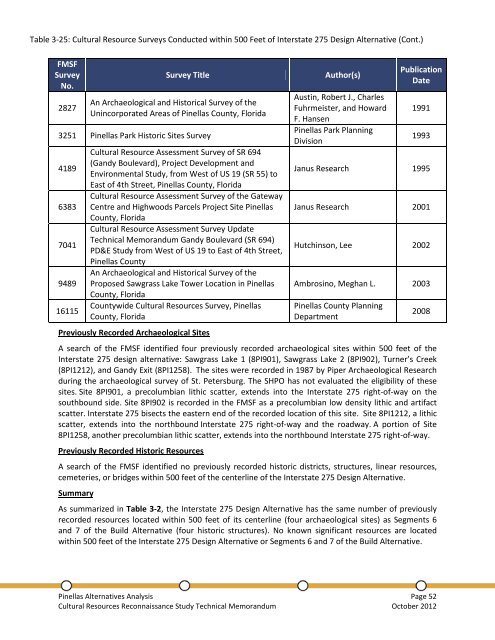
Table 3-25: Cultural Resource Surveys Conducted within 500 Feet of Interstate 275 Design Alternative (Cont.)FMSFSurveyNo.2827Survey TitleAn Archaeological and Historical Survey of theUnincorporated Areas of <strong>Pinellas</strong> County, Florida3251 <strong>Pinellas</strong> Park Historic Sites Survey418963837041948916115Cultural Resource Assessment Survey of SR 694(Gandy Boulevard), Project Development andEnvironmental Study, from West of US 19 (SR 55) toEast of 4th Street, <strong>Pinellas</strong> County, FloridaCultural Resource Assessment Survey of the GatewayCentre and Highwoods Parcels Project Site <strong>Pinellas</strong>County, FloridaCultural Resource Assessment Survey UpdateTechnical Memorandum Gandy Boulevard (SR 694)PD&E Study from West of US 19 to East of 4th Street,<strong>Pinellas</strong> CountyAn Archaeological and Historical Survey of theProposed Sawgrass Lake Tower Location in <strong>Pinellas</strong>County, FloridaCountywide Cultural Resources Survey, <strong>Pinellas</strong>County, FloridaPreviously Recorded Archaeological SitesAuthor(s)Austin, Robert J., CharlesFuhrmeister, and HowardF. Hansen<strong>Pinellas</strong> Park PlanningDivisionPublicationDate19911993Janus Research 1995Janus Research 2001Hutchinson, Lee 2002Ambrosino, Meghan L. 2003<strong>Pinellas</strong> County PlanningDepartmentA search of the FMSF identified four previously recorded archaeological sites within 500 feet of theInterstate 275 design alternative: Sawgrass Lake 1 (8PI901), Sawgrass Lake 2 (8PI902), Turner’s Creek(8PI1212), and Gandy Exit (8PI1258). The sites were recorded in 1987 by Piper Archaeological Researchduring the archaeological survey of St. Petersburg. The SHPO has not evaluated the eligibility of thesesites. Site 8PI901, a precolumbian lithic scatter, extends into the Interstate 275 right-of-way on thesouthbound side. Site 8PI902 is recorded in the FMSF as a precolumbian low density lithic and artifactscatter. Interstate 275 bisects the eastern end of the recorded location of this site. Site 8PI1212, a lithicscatter, extends into the northbound Interstate 275 right-of-way and the roadway. A portion of Site8PI1258, another precolumbian lithic scatter, extends into the northbound Interstate 275 right-of-way.Previously Recorded Historic ResourcesA search of the FMSF identified no previously recorded historic districts, structures, linear resources,cemeteries, or bridges within 500 feet of the centerline of the Interstate 275 Design Alternative.SummaryAs summarized in Table 3-2, the Interstate 275 Design Alternative has the same number of previouslyrecorded resources located within 500 feet of its centerline (four archaeological sites) as Segments 6and 7 of the Build Alternative (four historic structures). No known significant resources are locatedwithin 500 feet of the Interstate 275 Design Alternative or Segments 6 and 7 of the Build Alternative.2008<strong>Pinellas</strong> <strong>Alternatives</strong> <strong>Analysis</strong> Page 52Cultural Resources Reconnaissance Study Technical Memorandum October 2012