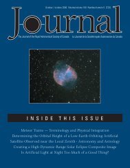
crew of meteorologists to get their helium-filled Kytoon totow aloft a cable with high-speed sensors for measuringthermal turbulence (Figure 4).A forecast of rough fall weather was coming true. On 1966July 25, I had arrived in Penticton with Mel Lytle, the DominionObservatory’s carpenter. We set up a small camp on the summitand, in steady blazing sunshine, we erected two observingplatforms, 5-m high. My plan was to compare the quality ofsolar images photographed by a pair of 15-cm refractors onplatforms that were spaced 1.5 km apart on the mountain’splateau. Two weeks of labouring at construction had landedme in Penticton Hospital on August 7 with muscular spasmsgripping my back. Midway through a week of treatment, Icommented to the physiotherapist that it had been cloudy thatmorning since sunrise, the first such day since I arrived fromOttawa. Her matter-of-fact response startled me: “Oh, thatjust means we’re going to have an early fall.” Her confidentprediction was rooted in years of tending an apricot orchardon one of the westward-facing terraces rising above OkanaganLake. She explained that there were years when the seeminglyendless sunny days stopped abruptly; cloudy days then becamecommonplace and prevailed until spring.This was my first exposure to any negative comment aboutfall or winter weather in the Okanagan. What I had been toldearlier about winter conditions on Mt. Kobau emphasizedpositive aspects; the summit was sometimes seen rising throughthe cloud at night by pilots descending to land at Penticton, orduring the day by skiers on higher slopes nearby. Conditionshad indeed changed when I got back to the mountain a weekor two later. Cirrus-streaked skies predominated. Even so wewere encouraged by good days with short periods lastingapproximately 30 minutes when image definition over afield-of-view of 6′ × 6′ was aperture-limited (Figure 5). On thenext-to-last day of our campaign, August 30, we awakened toa nasty shock; heavy hoar frost covered our tents and trailer tothe depth of a centimetre (Figure 6). <strong>The</strong>re was no longerdoubt about an early fall.Back in our slowly ascending Scout, Aren and I disputed thenumber and sharpness of the turns we had already made andhow many were left. <strong>The</strong> odometer was too coarse to indicatethe remaining distance to the camp. Suddenly our headlightspicked out through the fog two red taillights at the spacing ofa large truck. I raged at the abandonment of a large vehiclewhere it blocked the road. I crept up to it, aiming a bit towardsthe side I thought was opposite to the mountain’s edge. Movinggingerly, Aren got out to investigate. He came back doubledup with laughter, motioning for me to come and inspect the“vehicle.” It was the storage/workshop trailer in the encampmentof three large trailers! We had arrived at the summit in fog sothick that we could only see the end of that one trailer. Wegroped our way to the commissary, roused the cook, and wolfeddown a hot supper before turning in for the night.Figure 5 — Sunspot Region McMath 8454 as it was forming on 1966 August 24.Figure 6 — Hoar frost covers the solar site-testing camp 1966 August 30. <strong>The</strong>all-white observing platform for the solar refractor is at upper left.Figure 7 — Fog-bound journalists and photographers at the summit,1966 October 23.98 JRASC | Promoting Astronomy In Canada June / juin 2011
<strong>The</strong> next day, Sunday, 1966 October 23, was scheduled for anon-site visit by the National Advisory Committee on Astronomy(NACA). This body was appointed to advise the Minister ofMines & Technical Surveys (MTS), the federal agency thenresponsible for the operation of the Observatories Branch, onthe development of a national observatory on Mt. Kobau. Atmid-morning, the mountain was still shrouded in fog. That didnot discourage a couple of carloads of newspaper reportersfrom making their way to the summit (Figure 7) to await thearrival of a busload of senior Canadian scientists and theirguests. <strong>The</strong> site manager for A.B. Sanderson was reluctant topermit that bus to proceed up the mountain until he wasassured by the meteorologist at Penticton Airport that the fogwas lifting. After more than an hour’s delay, the bus arrived inthinning fog (Figure 8). Its occupants were treated to hot drinks(Figure 9) before they set off to tramp over to the summit inankle-deep sticky snow (Figure 10).Figure 8 — Busload of distinguished scientists guided to a parking spot bySite <strong>Man</strong>ager Jock Crawford.<strong>The</strong> visit did not convert doubters into believers that Mt. Kobauwas the best site for Canada’s major optical telescope. Neitherwere there any defectors from among the faithful at the nextday’s meeting of the NACA in Penticton. <strong>The</strong> virtues of Mt.Kobau were stoutly defended. But there was growing insistenceby astronomers from eastern Canada for a national astronomicalfacility to be located in the Southern Hemisphere.3. Early Impressions of Mt. KobauMy initial impressions of Mt. Kobau had been favourable.I first visited the mountain on 1965 October 01 with J.L.( Jack) Locke, then Chief of the Stellar Physics Division at theDominion Observatory, Ottawa. Together with R.M. (Bert)Petrie, Dominion Astronomer and Director of DAO, and hiswife Jean, we bounced along a rough trail to the summit in aLand Rover driven by Graham Odgers. At the top, we found along, broad ridge aligned generally north-south with its highestpoint at its SE corner on a knoll surmounted by a fire lookout.<strong>The</strong> slightly lower location for the QE II Telescope was on alarge hillock a few hundred metres to the NW, marked by asmall cement pad beneath the map that is the centre of attentionin Figure 11. Most of the southern end of the ridge wasboulder-strewn open meadow covered with sagebrush and variousgrasses that looked tinder dry in early autumn. Isolated standsof alpine fir dotted the landscape.A large depression, called Testalinden Lake (Figure 12), about0.5 km north of the primary site, had been scooped out decadesearlier by local orchardists to impound water for irrigation.When filled by spring snow-melt, the lake covered over ahectare to a maximum depth of 2.4 m. Studies were underwayabout the practicality of sealing the lake bottom to create areservoir for both agricultural and astronomical needs. <strong>The</strong>NW side of Testalinden Lake was heavily forested, but soonopened onto a broad, sage-covered meadow. Beyond that meadow,a thick forest of mixed conifers, including stands of talllodgepole pine, covered the northern extremes of the ridge.Figure 9 — Future Nobel Laureate Gerhard Herzberg (extreme right) chatswith future First Director of the Herzberg Institute of Astrophysics, Jack Locke(left), 1966 October 23.A few hours spent tramping around the ridge that mild hazyday sufficed to pick several locations worth testing as sites for asolar tower telescope. I came away convinced that Mt. Kobauwas a valid choice for a multi-disciplinary national observatory.My companions of that day felt otherwise. Odgers was bluntlypessimistic; he had spent enough days on the mountain torecognize a consistent upflow on its flanks by mid-morningthat produced abundant local cumulus clouds above the ridge.I was already aware of this tendency at mountain solar sites inthe U.S. southwest, specifically at Kitt Peak (Arizona) andSacramento Peak (New Mexico). In each case, they countedon tower telescopes at sufficient height to be above the earlymorning inversion layers for optimum observing conditions.Estimation of the minimum tower height was to be part ofmy site investigations. Petrie was far more concerned with thedistracting effect of other telescopes proposed for Mt. Kobauon the quick completion of the QEII Telescope.June / juin 2011JRASC | Promoting Astronomy In Canada99