Hydrogeology and siting of micro-dams around Léo Burkina Faso
Hydrogeology and siting of micro-dams around Léo ... - SamSamWater
Hydrogeology and siting of micro-dams around Léo ... - SamSamWater

You also want an ePaper? Increase the reach of your titles
YUMPU automatically turns print PDFs into web optimized ePapers that Google loves.
<strong>Hydrogeology</strong> <strong>and</strong> <strong>siting</strong> <strong>of</strong> <strong>micro</strong>-<strong>dams</strong> <strong>around</strong> <strong>Léo</strong>, <strong>Burkina</strong> <strong>Faso</strong>14 June 2010Index1 Introduction 11.1 Background 11.2 Purpose <strong>of</strong> visit 12 Area 12.1 Location 12.2 Climate 12.3 Geology <strong>and</strong> topography 12.4 Vegetation 13 Micro-<strong>dams</strong> constructed in 2008-2009 13.1 Introduction 13.2 Sanga 13.3 Danfina 13.4 Tabou 14 Hydrogeological assessment <strong>of</strong> the <strong>micro</strong>-<strong>dams</strong> 14.1 Last year’s measurements 14.2 Hydrology <strong>around</strong> the Sanga <strong>micro</strong>-dam 14.3 Water quality <strong>around</strong> the Sanga <strong>micro</strong>-dam 14.4 Hydrology <strong>around</strong> the Sissili proposed <strong>micro</strong>-dam site 14.5 Water balance Sanga (<strong>micro</strong>-dam constructed in 2008-2009) 14.6 Water balance Danfina (<strong>micro</strong>-dam constructed in 2008-2009) 14.7 Effect <strong>of</strong> a <strong>micro</strong>-dam on downstream water availability 14.8 Hydrological monitoring system 15 Proposed sites for <strong>micro</strong>-dam construction 15.1 Introduction 15.2 Kayéro 15.3 Kayérobo 15.4 Onliassan 15.5 Tékoura 15.6 Sissili 16 Potential additional new sites for <strong>micro</strong>-dam construction 16.1 Introduction 16.2 Yelbouga 16.3 Bonapia 17 Conclusions <strong>and</strong> recommendations 17.1 Hydrogeological assessment <strong>of</strong> the <strong>micro</strong>-<strong>dams</strong> 17.2 Other conclusions <strong>and</strong> recommendations 17.3 Suitability <strong>of</strong> proposed <strong>and</strong> potential sites for <strong>micro</strong>-dam construction 11
<strong>Hydrogeology</strong> <strong>and</strong> <strong>siting</strong> <strong>of</strong> <strong>micro</strong>-<strong>dams</strong> <strong>around</strong> <strong>Léo</strong>, <strong>Burkina</strong> <strong>Faso</strong>14 June 20108 References 18.1 Text 18.2 Maps 18.3 S<strong>of</strong>tware 1Appendix 1 Topographic map 1Appendix 2 Overview <strong>of</strong> population <strong>and</strong> water users per site (source: CREDO) 1Appendix 3 Monitoring plan 1Appendix 4 Mission story 12
<strong>Hydrogeology</strong> <strong>and</strong> <strong>siting</strong> <strong>of</strong> <strong>micro</strong>-<strong>dams</strong> <strong>around</strong> <strong>Léo</strong>, <strong>Burkina</strong> <strong>Faso</strong>14 June 20101 Introduction1.1 BackgroundSince 2006 CREDO, a <strong>Burkina</strong> <strong>Faso</strong> based NGO, implements a four year water program in the South <strong>of</strong><strong>Burkina</strong> <strong>Faso</strong>.The objectives <strong>of</strong> the programme are:• To facilitate sustainable access to safe water for drinking <strong>and</strong> household use.• To reduce waterborne diseases by promoting hygiene practices <strong>and</strong> sanitation.One <strong>of</strong> the activities <strong>of</strong> the programme is the construction <strong>of</strong> <strong>micro</strong>-<strong>dams</strong> to increase the water levelsin surrounding wells. In 2008 CREDO started the renovation <strong>of</strong> two <strong>micro</strong>-<strong>dams</strong> (in Sanga <strong>and</strong>Danfina), after the consultation <strong>of</strong> two Dutch experts, Mr. Henk Haas <strong>and</strong> Mr. Huib Povel. The two<strong>micro</strong>-<strong>dams</strong> are finished now, a third one (Tabou) is under construction.The programme is funded by the European Commission (EC), <strong>and</strong> the Dutch NGO’s Aqua for All (A4A)<strong>and</strong> Woord en Daad.In 2008 Woord en Daad submitted a proposal to Aqua for All for the construction <strong>of</strong> three more<strong>micro</strong>-<strong>dams</strong>. Aqua for All proposed to do a geophysical <strong>and</strong> hydrogeological research first, beforeproceeding with the construction <strong>of</strong> the <strong>micro</strong>-<strong>dams</strong>. Besides this, Aqua for All asked for a monitoringplan for the collection <strong>of</strong> information on key indicators like precipitation <strong>and</strong> water availability in thewells as the scientific preparation for the proposed construction <strong>of</strong> the three more <strong>micro</strong>-<strong>dams</strong>.1.2 Purpose <strong>of</strong> visitIn January 2010 Aqua for All asked S<strong>and</strong>er de Haas to carry out a mission to <strong>Burkina</strong> <strong>Faso</strong> to assessthe hydrogeological aspects <strong>of</strong> this project. This mission report is the result <strong>of</strong> the mission that tookplace from 10 February 2010 until 23 February 2010.The purpose <strong>of</strong> the mission is to define a scientific methodology to asses existing <strong>micro</strong>-<strong>dams</strong> <strong>and</strong>potential sites for new <strong>micro</strong>-<strong>dams</strong>. To achieve this the following activities were planned:1. Assess the effects <strong>of</strong> the two <strong>micro</strong>-<strong>dams</strong> in Sanga <strong>and</strong> Danfina on water levels in the wells<strong>and</strong> on water quality. Besides that, look at rain water data <strong>and</strong> information about water use(e.g. for drinking water, gardening, livestock, etc.).2. Assess the suitability <strong>of</strong> five sites (as selected by CREDO) for <strong>micro</strong>-dam construction, with theexpected effect on the availability <strong>of</strong> drinking water as the main criterion (raising the watertable in the wells) <strong>and</strong> also the costs for the construction <strong>of</strong> the <strong>micro</strong>-dam;3. Develop together with CREDO a system to monitor (with the communities) the effect <strong>of</strong> the<strong>micro</strong>-<strong>dams</strong>: water level in the wells <strong>and</strong> in deeper water layers, data on precipitation, waterquality (pH, conductivity) <strong>and</strong> water use (drinking water, gardens, livestock);4. Train CREDO's technician.Unfortunately no technician has been hired at the time <strong>of</strong> writing. So instead <strong>of</strong> training I tried toexplain as much as possible to the program manager <strong>and</strong> write it down in this report.3
<strong>Hydrogeology</strong> <strong>and</strong> <strong>siting</strong> <strong>of</strong> <strong>micro</strong>-<strong>dams</strong> <strong>around</strong> <strong>Léo</strong>, <strong>Burkina</strong> <strong>Faso</strong>14 June 20102 Area2.1 LocationThe recently constructed <strong>dams</strong> <strong>and</strong> all proposed sites for dam construction are located within a 40 kmradius <strong>of</strong> <strong>Léo</strong>, in the province <strong>of</strong> Sissili in the South <strong>of</strong> <strong>Burkina</strong> <strong>Faso</strong>. <strong>Léo</strong> is located about 10 km north<strong>of</strong> the border between <strong>Burkina</strong> <strong>Faso</strong> <strong>and</strong> Ghana.CREDO has an <strong>of</strong>fice <strong>and</strong> compound in Kayéro, about 14 km North <strong>of</strong> <strong>Léo</strong>. All dam sites are shown onFigure 1, a more detailed topographic map is added in Appendix 1.Figure 1 Overview map, blue markers indicate a (potential) dam site, red markers are forreference2.2 ClimateThe average annual temperature in the area is 27.5 °C. March is the warmest month with an averagemaximum temperature <strong>of</strong> 38.2 °C <strong>and</strong> December is the coolest month with an average minimumtemperature <strong>of</strong> 18.7 °C. At the time <strong>of</strong> this mission it was extremely warm for the season withtemperatures rising to above 40 °C.4
<strong>Hydrogeology</strong> <strong>and</strong> <strong>siting</strong> <strong>of</strong> <strong>micro</strong>-<strong>dams</strong> <strong>around</strong> <strong>Léo</strong>, <strong>Burkina</strong> <strong>Faso</strong>14 June 2010Annual rainfall is on average <strong>around</strong> 940 mm (FAO, 2005). Generally, the rainy season starts in earlyMay <strong>and</strong> ends in late September or October, depending on the year. Although the last years rainfall isbecoming more erratic <strong>and</strong> concentrated in the months July, August <strong>and</strong> September.Annual potential evapotranspiration is <strong>around</strong> 1660 mm (FAO, 2005).All rivers in the area are seasonal <strong>and</strong> discharge only occurs during <strong>and</strong> shortly after the rainy season.After that, surface water is only present in (natural) depressions in the rivers, upstream <strong>of</strong> <strong>dams</strong> <strong>and</strong>in pits along the road where water from the road surface is being diverted to.Figure 2 shows the average precipitation <strong>and</strong> potential evapotranspiration throughout the year withtheir st<strong>and</strong>ard deviations.109Precipitationst<strong>and</strong>ard deviatonPETst<strong>and</strong>ard deviaton876mm/day5432101-jan1-feb1-mrt1-apr1-mei1-jun1-jul1-aug1-sep1-okt1-nov1-decFigure 2 Precipitation <strong>and</strong> potential evpotranspiration throughout the year for <strong>Léo</strong> based onNew_LocClim (FAO, 2005)2.3 Geology <strong>and</strong> topographyThe area <strong>around</strong> <strong>Léo</strong> is relatively flat with shallow incised river valleys. The elevations <strong>around</strong> the areavary between 300 <strong>and</strong> 350 meter above sea level. The sub-surface consists <strong>of</strong> undifferentiatedmigmatites <strong>and</strong> granito-gneisses <strong>of</strong> Precambrian age (Hottin, G. & Ouedraogo, O.F., 1976 <strong>and</strong>Direction de la Géologie et des Mines, 1968).The upper part <strong>of</strong> the soil consist <strong>of</strong> weathering products from the crystalline basement. This top partis mostly clay <strong>and</strong>/or laterite. Although only slightly permeable this top layer has a high storagecapacity <strong>and</strong> forms an aquifer. H<strong>and</strong> dug wells <strong>and</strong> scoopholes are constructed in this upper aquifer.In the river valleys (especially in depressions <strong>and</strong> upstream <strong>of</strong> <strong>dams</strong>) the soil is covered by a layer <strong>of</strong>clay sedimented by the river. This top layer <strong>of</strong> clay varies in depth between a few mm’s to more than ameter. The upper part <strong>of</strong> it dries <strong>and</strong> cracks during the dry season.5
<strong>Hydrogeology</strong> <strong>and</strong> <strong>siting</strong> <strong>of</strong> <strong>micro</strong>-<strong>dams</strong> <strong>around</strong> <strong>Léo</strong>, <strong>Burkina</strong> <strong>Faso</strong>14 June 2010Figure 3 From left to right: granito-gneiss outcrop, laterite <strong>and</strong> clayThe fractured top part <strong>of</strong> the underlying crystalline basement forms a deeper aquifer. Since the waterwill only be stored <strong>and</strong> transported trough fractures, this aquifer is discontinuous, has a lowpermeability <strong>and</strong> very low storage capacity. Most (all?) boreholes (“forages”) are constructed in thisaquifer.Figure 4 From left to right: a scoophole, an uncovered (h<strong>and</strong> dug) well <strong>and</strong> a borehole withh<strong>and</strong> pumpAccording to the geophysical measurements carried out in 2010 by DEC Ltd the top <strong>of</strong> the crystallinebasement near the river varies between a few meters <strong>and</strong> about 20 m below ground level. Moredetails on the geophysical measurements <strong>and</strong> geology (drill logs) can be found in the reports “Travauxde realization de dix (10) forages positives equips de pompe volonta dans les communes de Bieha,Kassou, Leo en Tho, Provinces de la Sissili et du Ziro - Rapport de fin de travaux“ (CREDO / BESER Sarl,2009) <strong>and</strong> “Rapport d'investigations geophysiques sur cinq (5) sites de <strong>micro</strong>-barrages dans laProvince de la Sissili pour le compte de CREDO “ (DEC Ltd, 2010).6
<strong>Hydrogeology</strong> <strong>and</strong> <strong>siting</strong> <strong>of</strong> <strong>micro</strong>-<strong>dams</strong> <strong>around</strong> <strong>Léo</strong>, <strong>Burkina</strong> <strong>Faso</strong>14 June 20102.4 VegetationThe area is covered by savannah trees <strong>and</strong> shrubs. Along the river (<strong>and</strong> especially near <strong>dams</strong>) smallscale agricultural plots (“jardins”) can be found were vegetables are grown using irrigation water fromthe surface water or (shallow) wells <strong>and</strong> scoopholes.Figure 5 Small-scale agriculture plot near the <strong>micro</strong>-dam <strong>of</strong> DanfinaAt many locations (all over the area) bushfires <strong>and</strong> the carbonised remains <strong>of</strong> bushfires are found.Grasses, shrubs <strong>and</strong> trees are set on fire for no particular reason (“just to see how far it gets”). As aresult <strong>of</strong> this vast areas <strong>of</strong> l<strong>and</strong> contain no, or hardly any undergrowth (most trees seem to survive).This greatly increases the risk <strong>of</strong> erosion <strong>and</strong> reduces infiltration during the rainy season since therains will slam the soil preventing water from infiltrating. Starting bushfires is illegal in the area, butthat doesn’t seem to make a difference. CREDO also opposes starting bushfires, but these instructionsshould be intensified, especially in the catchments <strong>of</strong> the <strong>micro</strong>-<strong>dams</strong> since bushfires will greatlyincrease the risk <strong>of</strong> siltation <strong>of</strong> the <strong>dams</strong>.Figure 6 An area without any undergrowth due to recent bushfires (left) <strong>and</strong> desertificationnear Bonapio, partly (or greatly) caused by bushfires (right)7
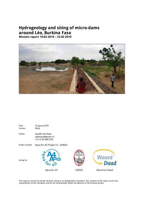
<strong>Hydrogeology</strong> <strong>and</strong> <strong>siting</strong> <strong>of</strong> <strong>micro</strong>-<strong>dams</strong> <strong>around</strong> <strong>Léo</strong>, <strong>Burkina</strong> <strong>Faso</strong>14 June 20103 Micro-<strong>dams</strong> constructed in 2008-20093.1 IntroductionDuring the mission 3 sites were visited where <strong>dams</strong> were constructed in 2008 <strong>and</strong> 2009 by CREDO, 5proposed sites for dam construction <strong>and</strong> (on request <strong>of</strong> CREDO) 2 additional potential sites for damconstruction.The locations <strong>of</strong> all dam sites (<strong>and</strong> their catchment areas) are presented in Figure 7. The three siteswhere a dam was constructed in 2008-2009 will be discussed in the following paragraphs. Theproposed <strong>and</strong> potential sites will be discussed in the next chapters.Figure 7 Locations <strong>of</strong> <strong>micro</strong>-<strong>dams</strong> <strong>and</strong> proposed sites. The green line indicates the catchmentarea <strong>of</strong> each dam site.Details on the population, the number <strong>of</strong> water users <strong>and</strong> cattle per site was collected by CREDO inthe document “Les données sur l’exploitation des anciens <strong>micro</strong>-barrages et nouveaux sites” (CREDO,2010). This document is reproduced in Appendix 2.3.2 SangaThe <strong>micro</strong>-dam <strong>of</strong> Sanga is located about 9.5 km East <strong>of</strong> <strong>Léo</strong>. The dam is constructed betweenNovember 2008 <strong>and</strong> March 2009. More details on the dimensions <strong>and</strong> construction can be found in“Description du barrage de Sanga, révisé” (Henk Haas, 2008). The catchment area <strong>of</strong> this dam has asurface area <strong>of</strong> 2.8 km 2 (the smallest <strong>of</strong> all visited sites).At the time <strong>of</strong> visit the water level was 1.34 m below the level <strong>of</strong> the spillway. According to thevillagers the surface water never dries up completely, although the area greatly reduces near the end<strong>of</strong> the dry season. At the time <strong>of</strong> visit the surface water covered an area <strong>of</strong> about 3,000 m 2 . The8
<strong>Hydrogeology</strong> <strong>and</strong> <strong>siting</strong> <strong>of</strong> <strong>micro</strong>-<strong>dams</strong> <strong>around</strong> <strong>Léo</strong>, <strong>Burkina</strong> <strong>Faso</strong>14 June 2010maximum surface area <strong>of</strong> the reservoir upstream <strong>of</strong> the <strong>micro</strong>-dam was measured with a spirit levelinstrument <strong>and</strong> GPS <strong>and</strong> is about 16,300 m 2 .Figure 8 Overview <strong>of</strong> the Sanga dam siteThe surface water in the reservoir is intensely used by people fetching water in barrels for brickmaking, washing clothes <strong>and</strong> cattle. On the riverbanks <strong>around</strong> (<strong>and</strong> especially just downstream <strong>of</strong>) thedam are many agricultural plots. In <strong>and</strong> <strong>around</strong> these agricultural plots there are several scoopholes,mainly downstream <strong>of</strong> the dam. Some <strong>of</strong> them were dry at the time <strong>of</strong> visit, but most <strong>of</strong> themcontained water (generally 1 - 2 m deep).Around the agricultural plots just downstream <strong>of</strong> the dam there are also 3 deeper wells (6 - 8 m deep).One well (nr. 3) is contaminated <strong>and</strong> contains very dirty water. This well isn’t used. Water from theother two wells is used for drinking <strong>and</strong> washing, but also for agriculture when the shallowerscoopholes have dried up.The soil in the riverbed consists <strong>of</strong> clay on top <strong>of</strong> laterite. The clay is the thickest in the lowest parts <strong>of</strong>the reservoir <strong>and</strong> the thickness gradually decreases towards the sides.CREDO told that they have considered to remove the clay upstream <strong>of</strong> the dam to increase infiltration.They decided not to do so because they were afraid that there would be no more surface water left atthe end <strong>of</strong> the dry season.Drinking water is currently being fetched from the uncovered open wells near the dam <strong>and</strong> in aborehole in the village (constructed by CREDO last year). There used to be more water points(boreholes) in the village, but they are broken.3.3 DanfinaThe <strong>micro</strong>-dam <strong>of</strong> Danfina (or Danfouna as indicated on some maps) is located about 17 km North-East <strong>of</strong> <strong>Léo</strong>. The dam is constructed between November 2008 <strong>and</strong> March 2009. More details on thedimensions <strong>and</strong> construction can be found in “Description du barrage de Danfina, révisé” (Henk Haas,2008). The catchment area <strong>of</strong> this dam has a surface area <strong>of</strong> 11.1 km 2 .Figure 9 Overview <strong>of</strong> the Danfina dam siteAt the time <strong>of</strong> visit the water level was 0.66 m below the level <strong>of</strong> the spillway <strong>and</strong> covered an area <strong>of</strong>about 12,000 m 2 .9
<strong>Hydrogeology</strong> <strong>and</strong> <strong>siting</strong> <strong>of</strong> <strong>micro</strong>-<strong>dams</strong> <strong>around</strong> <strong>Léo</strong>, <strong>Burkina</strong> <strong>Faso</strong>14 June 2010Signs <strong>of</strong> erosion (gullies) are visible on both sides <strong>of</strong> the dam. During the rainy season the water levelgets so high that water flows over <strong>and</strong> <strong>around</strong> the dam (not only the spillway) damaging the dam <strong>and</strong>creating erosion gullies. These problems were discussed with Henk Haas <strong>and</strong> Huib Povel <strong>and</strong> plans arecurrently being made to fix these problems.The soil in the riverbed consists <strong>of</strong> clay on top <strong>of</strong> laterite. At some locations the laterite has a highs<strong>and</strong> content making the scoopholes collapse.The surface water reservoir is intensely used by people fetching water in barrels for brick making,washing clothes <strong>and</strong> cattle. On the riverbanks <strong>around</strong> the dam are many agricultural plots located. In<strong>and</strong> <strong>around</strong> these agricultural plots there are several scoopholes. Some <strong>of</strong> them were dry at the time<strong>of</strong> visit, but most <strong>of</strong> them contained water (generally a few meters deep).Further away from the dam (200 – 300 m on the riverbanks) are a number <strong>of</strong> old open h<strong>and</strong>dug wells.They are only used if the shallow wells/scoopholes near the dam dry up.Drinking water is currently being fetched from boreholes <strong>and</strong> a number <strong>of</strong> water points in the village.The water from the shallow wells/scoopholes near the dam is only used for irrigation.3.4 TabouThe <strong>micro</strong>-dam <strong>of</strong> Tabou (or Timbo as indicated on some maps) is located about 29 km North <strong>of</strong> <strong>Léo</strong>.Construction works on the dam took place between November 2008 <strong>and</strong> March 2009. Due to politicalproblems the work is not finished yet. CREDO hopes to restart the constructions soon. More details onthe dimensions <strong>and</strong> construction can be found in “Description du barrage de Tabou, révisé” (HenkHaas, 2008). The catchment area <strong>of</strong> this dam has a surface area <strong>of</strong> 564 km 2 .Figure 10 Overview <strong>of</strong> the Tabou dam siteAt the time <strong>of</strong> visit there was some surface water present in a number <strong>of</strong> small natural depressions inthe riverbed.On the riverbanks near the dam are a number <strong>of</strong> agricultural plots located. People fetch water fromscoopholes <strong>and</strong> shallow wells for irrigation. Normally water is fetched by lowering a bowl or bucketwith a rope, but at one (larger) scoophole a motor pump was present. According to the owner, thewater level drops quickly if he uses this pump, but after about 2 hours the water has risen again to it’soriginal level.The soil <strong>around</strong> the riverbed consists <strong>of</strong> clay on top <strong>of</strong> laterite.Since the construction <strong>of</strong> this dam was already decided, but not yet finished, the site is notrepresentative for a location with a <strong>micro</strong>-dam, nor for a location without a <strong>micro</strong>-dam, so no furthermeasurements were done at this site.10
<strong>Hydrogeology</strong> <strong>and</strong> <strong>siting</strong> <strong>of</strong> <strong>micro</strong>-<strong>dams</strong> <strong>around</strong> <strong>Léo</strong>, <strong>Burkina</strong> <strong>Faso</strong>14 June 20104 Hydrogeological assessment <strong>of</strong> the <strong>micro</strong>-<strong>dams</strong>4.1 Last year’s measurementsDuring the previous dry season (from December 2008 to May 2009) the water level in 9 wells in Sanga,Danfina <strong>and</strong> Tabou were measured once a month. The results <strong>of</strong> these measurements are presentedin the report ”Récolte de données sur les <strong>micro</strong>-barrages” by CREDO <strong>and</strong> are also presented in thischapter.SangaAt Sanga the measurements were carried out in wells nr. 1, 3 <strong>and</strong> 5 near the <strong>micro</strong>-dam (see Figure 15for the locations <strong>of</strong> the wells).The measurements show a declining water level in all three wells from December 2008 onwards. AfterFebruary 2009 one well dries up <strong>and</strong> in the other wells the water level declines further. In May 2009 asecond well is dry.4,543,53SangaWell 1 (2008-2009)Well 2 (2008-2009)Well 3 (2008-2009)Well 1 (Feb. 2010)Well 2 (Feb. 2010)Well 3 (Feb. 2010)2,521,510,50dec jan feb mrt apr meiFigure 11 Water level measurements in 3 wells at Sanga, the Sanga <strong>micro</strong>-dam was constructedbetween November 2008 <strong>and</strong> March 2009However, there is uncertainty on how the water levels were measured <strong>and</strong> whether or not (<strong>and</strong> how)any conversions or calculations have been done on the measured values. Above all, there is alsouncertainty on which well in the report is which well in the field.The measurements taken during the field visit in February 2010 are completely different compared tothe values measured a year earlier (the dots in Figure 11). This adds to the uncertainties <strong>and</strong> makes itimpossible to draw conclusions from the measurements.DanfinaThe measurements at Danfina were carried out in three old open h<strong>and</strong> dug wells about 200 to 300 maway from the dam.11
<strong>Hydrogeology</strong> <strong>and</strong> <strong>siting</strong> <strong>of</strong> <strong>micro</strong>-<strong>dams</strong> <strong>around</strong> <strong>Léo</strong>, <strong>Burkina</strong> <strong>Faso</strong>14 June 2010The measurements show a steadily declining water level from December 2008 until February 2009.After February 2009 one well falls dry <strong>and</strong> in the other wells the water declines further, but lessrapidly.109876DanfinaWell 1 (2008-2009)Well 2 (2008-2009)Well 3 (2008-2009)Well 1 (Feb. 2010)Well 2 (Feb. 2010)Well 3 (Feb. 2010)543210dec jan feb mrt apr meiFigure 12 Water level measurements in 3 wells at Danfina, the Danfina <strong>micro</strong>-dam wasconstructed between November 2008 <strong>and</strong> March 2009However there is uncertainty on how the water levels were measured <strong>and</strong> whether or not (<strong>and</strong> how)any conversions or calculations have been done on the measured values.The measurements taken during the field visit in February 2010 (the dots in Figure 12) are 4 to 7meters higher than the values measured a year earlier. This seems a rather large difference, too largeto be accounted for by the construction <strong>of</strong> the <strong>micro</strong>-dam. So probably also here something wentwrong with the measurements or calculations/conversions afterwards.TabouIn Tabou, the measurements were carried out in three open h<strong>and</strong> dug wells/scoopholes in anagricultural plot just upstream <strong>of</strong> the dam.The measurements show a declining water level from December 2008 until April 2009 when all threewells are almost dry. The measurement in May 2009 show an increase in the water level <strong>of</strong> all threewells, probably because <strong>of</strong> the first rains.12
<strong>Hydrogeology</strong> <strong>and</strong> <strong>siting</strong> <strong>of</strong> <strong>micro</strong>-<strong>dams</strong> <strong>around</strong> <strong>Léo</strong>, <strong>Burkina</strong> <strong>Faso</strong>14 June 20101210TabouWell 1 (2008-2009)Well 2 (2008-2009)Well 3 (2008-2009)86420dec jan feb mrt apr meiFigure 13 Water level measurements in 3 wells at TabouIt was not clear which well was which, so it was not possible to compare the measurements doneduring the field visit.4.2 Hydrology <strong>around</strong> the Sanga <strong>micro</strong>-damThe Sanga <strong>micro</strong>-dam was constructed between November 2008 <strong>and</strong> March 2009. By chance theGeoEye satellite captured two very high resolution images <strong>of</strong> the site shortly after the construction <strong>of</strong>the dam in May <strong>and</strong> June 2009 (Figure 14). These images are viewable in Google Earth <strong>and</strong> GoogleMaps (http://maps.google.com/maps?f=q&source=s_q&hl=nl&geocode=&q=&sll=11.067739,-2.051182&sspn=0.125678,0.219727&ie=UTF8&ll=11.096498,-2.009243&t=k&spn=). On the first image(taken at 25 May 2009) the area upstream <strong>of</strong> the dam is still dry, while only a few days later thesecond image (captured at 5 June 2009) shows that the first rains have filled the reservoir upstream <strong>of</strong>the dam. According to field measurements <strong>and</strong> observations, the reservoir was not completely full atthe time <strong>of</strong> the second satellite photo.13
<strong>Hydrogeology</strong> <strong>and</strong> <strong>siting</strong> <strong>of</strong> <strong>micro</strong>-<strong>dams</strong> <strong>around</strong> <strong>Léo</strong>, <strong>Burkina</strong> <strong>Faso</strong>14 June 2010Figure 14 Satellite image <strong>of</strong> the Sanga <strong>micro</strong>-dam site just before the first rains (left imagecaptured at 25 May 2009) <strong>and</strong> <strong>and</strong> shortly after the first rains (right image captured at 5 June2009)During the field visits in February 2010 the water level, electrical conductivity (EC), temperature <strong>and</strong>depth were measured <strong>of</strong> each scoophole <strong>and</strong> well surrounding the <strong>micro</strong>-dam <strong>of</strong> Sanga. Figure 15shows a satellite photo with the locations <strong>of</strong> all wells <strong>and</strong> scoopholes that were measured. The yellowline is the <strong>micro</strong>-dam, the red part it’s spillway. The light blue polygon is the area covered by waterwhen the water is at spillway level. The darker blue polygon is the surface water at 13 February 2010.The circles indicate wells, the squares scoopholes. All red wells <strong>and</strong> scoopholes are part <strong>of</strong> themonitoring programme. The white one’s aren’t but they were measured during the field visit.14
<strong>Hydrogeology</strong> <strong>and</strong> <strong>siting</strong> <strong>of</strong> <strong>micro</strong>-<strong>dams</strong> <strong>around</strong> <strong>Léo</strong>, <strong>Burkina</strong> <strong>Faso</strong>14 June 2010Figure 15 Overview <strong>of</strong> the wells <strong>and</strong> scoopholes near the Sanga <strong>micro</strong>-damBased on the measurements in the scoopholes <strong>and</strong> wells a longitudinal pr<strong>of</strong>ile was created showingthe water level in the shallow scoopholes <strong>and</strong> the deeper wells. Only the wells <strong>and</strong> scoopholes thatwere directly in, or near the riverbed were used for this pr<strong>of</strong>ile.Figure 16 Longitudinal pr<strong>of</strong>ile along the river at Sanga. The brown line is the ground surface,the blue line the shallow groundwater table. The purple line is the groundwater in the deeperwells. The numbers correspond to the well numbers in Figure 15.15
<strong>Hydrogeology</strong> <strong>and</strong> <strong>siting</strong> <strong>of</strong> <strong>micro</strong>-<strong>dams</strong> <strong>around</strong> <strong>Léo</strong>, <strong>Burkina</strong> <strong>Faso</strong>14 June 2010It can clearly be seen that there is a difference in the groundwater level between the shallowscoopholes <strong>and</strong> the two deeper wells. This shallow groundwater table is high near the surface waterupstream <strong>of</strong> the dam <strong>and</strong> slowly deepening downstream. The <strong>micro</strong>-dam is clearly recharging thisshallow groundwater table. Without a dam it would be lower, or possibly non existing anymore.In the two deeper wells a second (deeper) water level is visible. The water is 4 to 5 meters deeper thanthe shallow groundwater table. These wells probably abstract water from the weathered hard rock.Based on this single measurement it cannot be said if there is any connection between the waterlevels in these two wells, but this is likely. Both <strong>of</strong> them were in use at the time <strong>of</strong> measurement whichcan have a significant effect on the water level. Periodical measurements as planned (paragraph 4.8)should give more information on this.The influence <strong>of</strong> the <strong>micro</strong>-dam on the water level in the deeper wells is not as clear as it is on theshallow groundwater table. It is however likely that the shallow groundwater slowly percolates down<strong>and</strong> recharges the weathered hard rock aquifer were these deeper wells are in.With the measurements <strong>of</strong> the scoopholes <strong>and</strong> wells a cross-sectional pr<strong>of</strong>ile was also created. Forthis pr<strong>of</strong>ile only the measurements a few meters downstream <strong>of</strong> the dam were used, as well as thewell <strong>and</strong> borehole North <strong>of</strong> the <strong>micro</strong>-dam. During the field visit the water level in the borehole wasnot measured. The borehole was properly closed <strong>and</strong> bacteriological safe so no attempts were madeto open it for a measurement <strong>and</strong> risking polluting it. The depth <strong>and</strong> water level are based on thedrilling logs (CREDO / BESER Sarl, 2009). Figure 17 shows the cross-sectional pr<strong>of</strong>ile with the measuredwater levels <strong>and</strong> the geological information from the drilling log <strong>of</strong> the borehole.Figure 17 Cross-sectional pr<strong>of</strong>ile along the river at Sanga. The brown line is the groundlevel,the blue line the shallow groundwater table. The purple line the groundwater in the deeperwells. The numbers correspond to the well numbers in Figure 15.This pr<strong>of</strong>ile shows the shallow groundwater table (blue line) in the scoopholes increases in leveltowards the sides.It is possible, but not certain, that the weathered hard rock aquifer at the deeper well near the dam(nr. 1) <strong>and</strong> the old well near the road (nr .7) is hydraulically connected (purple line). As both wells areh<strong>and</strong>-dug they probably get their water from the weathered hard rock layer, this corresponds with thedrill log from the borehole 100 m away.The borehole in the village (at the far right side <strong>of</strong> the figure) is in a third aquifer with a different watertable (red line). The drilling log <strong>of</strong> this borehole shows that the borehole is drilled into the fracturedgranite aquifer.4.3 Water quality <strong>around</strong> the Sanga <strong>micro</strong>-damNo thorough analysis was done on water quality. Only electrical conductivity (EC) <strong>and</strong> temperaturewere measured once at each scoophole <strong>and</strong> well. Both temperature <strong>and</strong> EC are probably (largely)influenced by whether or not the scoophole or well was in use, but they can give an indication for thewater quality <strong>and</strong> local differences between water points.16
<strong>Hydrogeology</strong> <strong>and</strong> <strong>siting</strong> <strong>of</strong> <strong>micro</strong>-<strong>dams</strong> <strong>around</strong> <strong>Léo</strong>, <strong>Burkina</strong> <strong>Faso</strong>14 June 2010The EC <strong>of</strong> the surface water in the reservoir upstream <strong>of</strong> the dam was 173 μS/cm with a temperature<strong>of</strong> 25.9 °C.EC’s in the (shallow) scoopholes varied between 150 <strong>and</strong> 320 μS/cm. Temperatures varied between 23<strong>and</strong> 26 °C.EC’s in the (deeper) wells varied between 220 <strong>and</strong> 290 μS/cm. Temperatures varied between 25 <strong>and</strong> 27°C.The EC in the borehole was 105 μS/cm with a temperature <strong>of</strong> 30.4 °C. The high temperature isremarkable since the borehole was intensely used at the time <strong>of</strong> measurement, so the water wasdefinitely fresh from the borehole. Possibly the pumping mechanism (h<strong>and</strong> pump) warms the water.All EC’s indicate fresh water with relatively small amounts <strong>of</strong> dissolved ions. However, the EC is noindication for the <strong>micro</strong>-biological quality <strong>of</strong> the water.At the time <strong>of</strong> construction (January 2009) the water from the borehole was chemically <strong>and</strong>bacteriological tested in a laboratory (CREDO / BESER Sarl, 2009). No <strong>micro</strong>-biological contaminationwas found. It is remarkable that the EC at that time <strong>of</strong> construction was 600 μS/cm while in February2010 is was only 105 μS/cm.Some wells which were formerly used for drinking water are now polluted by litter <strong>and</strong> are no longerin use. Some wells <strong>and</strong> scoopholes that are use for gardening or for cattle are also polluted withdebris (sticks, old buckets, etc.) <strong>and</strong> contain animals (flies, lizards, frogs <strong>and</strong> bats).CREDO advises the people not to get drinking water from any well <strong>and</strong> only use the water fromboreholes. Since all wells are open und thus easily contaminated this is logical. But water from thesewells could very well be <strong>of</strong> drinking water quality if the well wouldn’t be open. Most (probably all)pollution (chemical <strong>and</strong> <strong>micro</strong>biological) comes from outside (dirty buckets, ropes, debris, animals). Ifsuch a well would be closed <strong>of</strong>f properly <strong>and</strong> fitted with a (h<strong>and</strong>) pump the water would probably beperfectly safe to drink.Although CREDO advises not to, some people still fetch their drinking water from the open wells.Some because it is convenient (e.g. because <strong>of</strong> the distance to the borehole). While others do itbecause the boreholes are too busy or far, or they like the (“clayey”) taste <strong>of</strong> water from the wellsbetter.4.4 Hydrology <strong>around</strong> the Sissili proposed <strong>micro</strong>-dam siteSissili is one <strong>of</strong> the proposed sites for construction <strong>of</strong> a new <strong>micro</strong>-dam. At the site <strong>and</strong> old dam ispresent that has recently broken down. More details on the Sissili site can be found in paragraph 5.6.The water level, electrical conductivity (EC), temperature <strong>and</strong> depth were measured at all wells <strong>and</strong>the only scoophole present. Figure 18 shows a satellite photo (taken at 5 June 2009) where a largesurface water reservoir can be seen upstream <strong>of</strong> the dam. At this time, the dam was not breached yet.When the dam exactly breached is not certain, but it is presumably when the water reached it’smaximum level at the end <strong>of</strong> June, just a few weeks after this image was taken. The yellow line is thedam, the black part shows were it has breached.The circles indicate wells, the square indicates a scoophole. All wells <strong>and</strong> the scoophole are part <strong>of</strong> themonitoring program.17
<strong>Hydrogeology</strong> <strong>and</strong> <strong>siting</strong> <strong>of</strong> <strong>micro</strong>-<strong>dams</strong> <strong>around</strong> <strong>Léo</strong>, <strong>Burkina</strong> <strong>Faso</strong>14 June 2010Figure 18 Overview <strong>of</strong> the wells <strong>and</strong> scoopholes near the Sissili <strong>micro</strong>-damThe measured water levels at the proposed dam site <strong>of</strong> Sissili show the hydrological situation <strong>of</strong> a sitewithout a dam (since the dam has breached <strong>and</strong> lost it’s purpose). Figure 19 shows the longitudinalcross-section on the riverbanks, close to the river.18
<strong>Hydrogeology</strong> <strong>and</strong> <strong>siting</strong> <strong>of</strong> <strong>micro</strong>-<strong>dams</strong> <strong>around</strong> <strong>Léo</strong>, <strong>Burkina</strong> <strong>Faso</strong>14 June 2010Figure 19 Longitudinal pr<strong>of</strong>ile along the river at Sissili. The brown line is the ground level, theblue line the shallow groundwater table. The numbers correspond to the well numbers inFigure 18.The groundwater table is gently sloping downstream, no effects <strong>of</strong> a dam can be seen. The water tablein all wells <strong>and</strong> the single scoophole are all more or less at the same depth <strong>and</strong> thus get their waterfrom the same aquifer (at least at the time <strong>of</strong> visit).It is however remarkable that the villagers claim that both wells in the agricultural plot downstream <strong>of</strong>the dam (the two on the left side <strong>of</strong> Figure 19, depth <strong>around</strong> 8 m) dry up <strong>around</strong> March as well as themuch deeper well (on the right side <strong>of</strong> Figure 19, <strong>around</strong> 20 m deep) about 200 m upstream. Thismight indicate that the lower part <strong>of</strong> the deep well is in a very poor aquifer. Meaning that once theupper aquifer (were the wells get their water from now) has dried up, the well can hardly extract anywater from the deeper aquifer. The planned measurements <strong>of</strong> the monitoring program should givemore information on whether this is the case or not.The cross-sectional pr<strong>of</strong>ile (Figure 20) shows a groundwater table that is nearly flat, or slightlydecreasing towards the riverbanks. The slight decrease might be caused by the extractions from thesewells <strong>and</strong> scoophole, or might be the residual result <strong>of</strong> the short period that the dam was still intact<strong>and</strong> there was water infiltrating from the river towards the riverbanks. The planned measurementsshould tell more about this.Figure 20 Cross-sectional pr<strong>of</strong>ile along the river at Sissili. The brown line is the ground level,the blue line the shallow groundwater table. The numbers correspond to the well numbers inFigure 18.19
<strong>Hydrogeology</strong> <strong>and</strong> <strong>siting</strong> <strong>of</strong> <strong>micro</strong>-<strong>dams</strong> <strong>around</strong> <strong>Léo</strong>, <strong>Burkina</strong> <strong>Faso</strong>14 June 20104.5 Water balance Sanga (<strong>micro</strong>-dam constructed in 2008-2009)Based on the few measurements done last year <strong>and</strong> the short visit this year it is hard to get acomplete underst<strong>and</strong>ing on the hydrology <strong>of</strong> the <strong>micro</strong>-<strong>dams</strong>. However, with all information gatheredit is possible to set up a basic water balance so it becomes clear which fluxes are most important inthe hydrology <strong>of</strong> <strong>around</strong> the <strong>micro</strong>-dam.Since the volume <strong>of</strong> the reservoir upstream <strong>of</strong> the dam is relatively small compared to the totalamount <strong>of</strong> discharge <strong>of</strong> the river, the reservoir will be filled quickly after the start <strong>of</strong> the rainy season<strong>and</strong> will remain completely full until the end <strong>of</strong> the rainy season.Once the rains have stopped the river will no longer flow <strong>and</strong> the reservoir will be filled up to the level<strong>of</strong> the spillway. Then, the level in the reservoir will start to decrease due to:- evaporation;- infiltration <strong>of</strong> water into the soil;- use <strong>of</strong> water by cattle (drinking);- use <strong>of</strong> water for other reasons (brick making, washing, gardening, etc.).In the case <strong>of</strong> Sanga, the water level at mid February was 1.34 m below the level <strong>of</strong> the spillway. Thelast rains had occurred at the end <strong>of</strong> October, so the drop in water level had occurred over a period <strong>of</strong>approximately 105 days.The decrease <strong>of</strong> the water level because <strong>of</strong> evaporation can be estimated based on historicalmeteorological data. The tool New_LocClim (FAO, 2005) produces a good estimation for the averagedaily evaporation. For the area <strong>around</strong> <strong>Léo</strong> the average total evaporation from the end <strong>of</strong> October tothe middle <strong>of</strong> February is 0.46 m. This means that 0.46 m <strong>of</strong> the total drop in water level is caused byevaporation.Infiltration is harder to estimate, since it largely depend on the soil. According to the experiencedlocal hydrogeologist Mr. Traore, the average infiltration <strong>around</strong> these types <strong>of</strong> soil is 2 to 5 mm/day.Over a period <strong>of</strong> 105 days infiltration causes a drop in water level <strong>of</strong> somewhere between 0.21 m(0.002 m/day x 105 days) <strong>and</strong> 0.53 m (0.005 m/day x 105 days).The drop in water level by cattle is mainly accounted for by cows. They are the largest in number inthe area <strong>and</strong> drink more than goats <strong>and</strong> sheep. According to CREDO a total number <strong>of</strong> 3000 cows usethe reservoir for drinking, although they don’t come to the Sanga reservoir every day. It is estimatedthat <strong>around</strong> 1000 cows come to drink at the reservoir every day. On average an African cow drinks 27liters water per day (Nissen-Petersen, 2006). The total amount <strong>of</strong> water that is used by cattle is:27 x 1000 = 27,000 = 27liter per cow cows liter m 3per day per day per dayTo calculate the effect on the water level this amount has to be divided by the surface area <strong>of</strong> thereservoir. The maximum surface area <strong>of</strong> the reservoir (when the reservoir is filled up to the spillway)is <strong>around</strong> 16,300 m 2 . In February the surface area <strong>of</strong> the water was reduced to <strong>around</strong> 3,000 m 2 . Sothe average surface area between October <strong>and</strong> February is <strong>around</strong> 9,700 m 2 . This is not completelyaccurate since in real the decrease in surface area will not be linear like it is assumed here, but thiscan be neglected.So between October <strong>and</strong> February 2,835 m 3 (27 m 3 /day * 105 days) <strong>of</strong> water is being extracted out <strong>of</strong>the reservoir with an average surface area <strong>of</strong> 9,700 m 2 . This has caused a drop in water level <strong>of</strong> 0.29 m(2,835 m 3 / 9,700 m 2 ).The decrease <strong>of</strong> water level for other sources like washing <strong>and</strong> brick making can be calculated in thesame way. Based on field observations the amount <strong>of</strong> water that is being extracted for brick making ismuch larger than the extractions for other sources (e.g. washing). Brick makers get water in 200 lbarrels which they fill at the reservoir <strong>and</strong> transport with a donkey-cart to the brick making site. It isestimated that on average 100 barrels are being filled per day. 100 barrels times 200 liter gives a totalextraction <strong>of</strong> 20,000 liter per day, which equals 20 m 3 per day. Divided by an average surface area <strong>of</strong>the reservoir <strong>of</strong> 9,700 m 2 , this causes a drop in water level <strong>of</strong> 0.22 m.20
<strong>Hydrogeology</strong> <strong>and</strong> <strong>siting</strong> <strong>of</strong> <strong>micro</strong>-<strong>dams</strong> <strong>around</strong> <strong>Léo</strong>, <strong>Burkina</strong> <strong>Faso</strong>14 June 2010So the total drop in water level between the end <strong>of</strong> October until February is estimated to be between1.49 <strong>and</strong> 1.18 m (depending on the rate <strong>of</strong> infiltration), see Table 1.In case <strong>of</strong>high infiltration(5 mm/day)In case <strong>of</strong>low infiltration(2 mm/day)Evaporation 0.46 m 0.46 mInfiltration 0.53 m 0.21 mCattle (cows) 0.29 m 0.29 mOther uses (brick making) 0.22 m 0.22 mTotal decrease in water level 1.49 m 1.18 mNote that water for irrigation is not taken into account here, since this water is (in the case <strong>of</strong> Sanga) extracted from scoopholes<strong>and</strong> wells <strong>and</strong> (usually) not from the surface water reservoir.Table 1 Decrease in water level at Sanga between October <strong>and</strong> FebruaryThe actual drop in water level was measured to be 1.34 m, which seems tot correspond well with thecalculated values. This gives confidence in the assumptions <strong>and</strong> estimations.The infiltration rate is probably closer to 5 mm per day, than to 2 mm per day. This makes sense withfield observations, since the thickness <strong>of</strong> the clay at Sanga was less compared to other sites.Now that all (or at least the major) factors influencing the surface water reservoir are known, it is alsopossible to calculate the total amount <strong>of</strong> water that infiltrates during a whole year because <strong>of</strong> a <strong>micro</strong>dam.For the following calculations an infiltration rate <strong>of</strong> 4 mm per day is assumed.The amount <strong>of</strong> water that infiltrates depends on the area covered by water <strong>and</strong> thus varies per month.Table 2 gives an overview <strong>of</strong> the surface area, the amount <strong>of</strong> evaporation, the amount <strong>of</strong> infiltration<strong>and</strong> water use by cattle <strong>and</strong> brick making per month. The calculation is based on a reservoir that iscompletely full in June, remains full (because <strong>of</strong> the ongoing rains) until October <strong>and</strong> then slowlydecreases in size by 35% each month. In this way the surface area in February corresponds to themeasured surface area at the time <strong>of</strong> visit <strong>and</strong> the reservoir doesn’t dry up completely at the end <strong>of</strong>the dry season (as claimed by the villagers).reservoirsize evaporation evaporationinfiltration(4 mm/day)cattle(cows)other users(brick making)m 2 mm/month m 3 m 3 m 3 m 3Jan 4,476 139 623 537 810 600Feb 2,910 142 414 349 810 600Mar 1,891 172 325 227 810 600Apr 1,229 170 209 148 810 600May 799 167 133 96 810 600Jun 16,300 139 2.258 1,956 810 600Jul 16,300 122 1.988 1,956 810 600Aug 16,300 111 1.816 1,956 810 600Sep 16,300 114 1.861 1,956 810 600Oct 16,300 132 2.156 1,956 810 600Nov 10,595 126 1.336 1,271 810 600Dec 6,887 127 871 826 810 600year 13,992 13,234 9,720 7,200Table 2 Reservoir size <strong>and</strong> amounts <strong>of</strong> evaporation, infiltration <strong>and</strong> water use for the reservoir<strong>of</strong> SangaAs can be seen in Table 2, a total amount <strong>of</strong> more than 13,000 m 3 <strong>of</strong> water infiltrates into the groundbecause <strong>of</strong> the <strong>micro</strong>-dam. This amount is about the same as the maximum volume <strong>of</strong> surface waterstored upstream <strong>of</strong> the dam. The volume is so large because during the rainy season the waterinfiltrates over a large area <strong>and</strong> the water in the reservoir is still replenished by the ongoing rains.According to CREDO <strong>around</strong> 700 people live near the Sange <strong>micro</strong>-dam. The <strong>micro</strong>-dam stores <strong>around</strong>13,000 m 3 <strong>of</strong> water into the ground, this equals an amount <strong>of</strong> 52 liter per person per day (all year21
<strong>Hydrogeology</strong> <strong>and</strong> <strong>siting</strong> <strong>of</strong> <strong>micro</strong>-<strong>dams</strong> <strong>around</strong> <strong>Léo</strong>, <strong>Burkina</strong> <strong>Faso</strong>14 June 2010round). Most probably not all <strong>of</strong> this ground water can be extracted, but this shows that the amount<strong>of</strong> ground water recharged by the <strong>micro</strong>-dam is significant.Apart from a year-round source for drinking water for cattle, brick making <strong>and</strong> washing, the <strong>micro</strong>damat Sanga adds 13,000 m 3 <strong>of</strong> groundwater to the area. Part <strong>of</strong> this infiltrated water is extracted bythe surrounding shallow wells <strong>and</strong> scoopholes for drinking <strong>and</strong> irrigation, another part percolatesdeeper into the ground <strong>and</strong> might recharge the deeper groundwater in the weathered <strong>and</strong> fracturedhard rocks. How much <strong>of</strong> the water will eventually flow towards these deeper aquifers is hard toestimate <strong>and</strong> depends on the local situation.4.6 Water balance Danfina (<strong>micro</strong>-dam constructed in 2008-2009)Using the same procedure as described above a water balance can be calculated for Danfina.In the case <strong>of</strong> Danfina, the water level at mid February was 0.66 m below the level <strong>of</strong> the spillway. Thelast rains had occurred at the end <strong>of</strong> October, so the 0.66 m drop in water level had occurred over aperiod <strong>of</strong> about 105 days.As at Sanga, evaporation has caused an estimated drop in water level <strong>of</strong> 0.46 m.The soil <strong>of</strong> the reservoir upstream <strong>of</strong> the Danfina <strong>micro</strong>-dam is more clayey than the soil in Sanga.When using the estimated low infiltration rate <strong>of</strong> 2 mm/day this will result in a drop <strong>of</strong> water level <strong>of</strong>0.21 m. In this case the evaporation <strong>and</strong> infiltration alone will result in a drop <strong>of</strong> water level <strong>of</strong> 0.67 m,which is about the same as the measured value <strong>of</strong> 0.66 m. Since water use by cattle <strong>and</strong> for brickmaking is not even taken into account this cannot be correct. So presumably the infiltration rate atDanfina is less than 2 mm/day.The estimated number <strong>of</strong> 1,000 cows that come to drink at the Danfina reservoir cause a drop inwater level <strong>of</strong> about 0.17 m. And the estimated 150 barrels a which are being filled result in a drop <strong>of</strong>about 0.19 m. Combined with the evaporation (but without infiltration) this adds up to a drop in waterlevel <strong>of</strong> 0.82 m, which is also more than the measured value <strong>of</strong> 0.66 m. So even when there is noinfiltration at all (which is unlikely) the estimations <strong>of</strong> evaporation <strong>and</strong> water use by cattle <strong>and</strong> brickmaking are too large. This means that either the evaporation or the use for cattle <strong>and</strong> brick making isoverestimated, or there is residual inflow <strong>of</strong> water to the reservoir (possibly delayed groundwater flowfrom the riverbanks or upstream).Additional measurements could indicate which <strong>of</strong> the parameters causes this difference. But based onthe measurements <strong>and</strong> estimations it can be said that the infiltration rate at Danfina is most probablylower than at Sanga, most likely <strong>around</strong> or lower than 2 mm/day. This corresponds to the fieldobservations since the soil <strong>of</strong> the reservoir was more clayey at Danfina compared to most other sites.4.7 Effect <strong>of</strong> a <strong>micro</strong>-dam on downstream water availabilityAn issue <strong>of</strong>ten raised regarding the construction <strong>of</strong> <strong>dams</strong> in arid areas is the effect on downstreamwater availability. Will the <strong>micro</strong>-dam reduce the water availability downstream?In the case <strong>of</strong> the <strong>micro</strong>-<strong>dams</strong> in this area that will not be the case. The effect on downstream wateravailability depends on the amount <strong>of</strong> water that is stored by the dam, compared to the total amount<strong>of</strong> water that flows through the river. If a substantial amount <strong>of</strong> the total discharge is stored upstream<strong>of</strong> a dam, downstream water availability might be at stake.Of the visited <strong>dams</strong>, Sanga has the smallest catchment size <strong>and</strong> is therefore the most sensitive in thisregard. Although even in the case <strong>of</strong> Sanga the <strong>micro</strong>-dam will only retain less than 0,5% <strong>of</strong> the totalamount <strong>of</strong> water that will flow through the river (volume <strong>of</strong> reservoir / (catchment size * averagerainfall * run<strong>of</strong>f coefficient)). Therefore there will be no negative downstream effects <strong>of</strong> a <strong>micro</strong>-dam.4.8 Hydrological monitoring systemA monitoring system was set up to monitor the hydrological situation at Sanga (where there is a<strong>micro</strong>-dam) <strong>and</strong> at Sissili (proposed dam site). The monitoring programme is added to this report inAppendix 2.22
<strong>Hydrogeology</strong> <strong>and</strong> <strong>siting</strong> <strong>of</strong> <strong>micro</strong>-<strong>dams</strong> <strong>around</strong> <strong>Léo</strong>, <strong>Burkina</strong> <strong>Faso</strong>14 June 2010At both locations a number <strong>of</strong> wells <strong>and</strong> scoopholes are selected in which the water level will bemonitored twice a month. The water level in the reservoir upstream <strong>of</strong> the <strong>micro</strong>-dam will bemeasured relative to the spillway twice a month.In the wells the water level will be measured relative to the rim <strong>of</strong> the well. In the scoopholes an ironrod has been hammered in the ground. The water level in the scoopholes will be measured relative tothis iron rod.The elevation <strong>of</strong> all reference points (rims <strong>of</strong> the wells <strong>and</strong> iron rods) has been measured with a spiritlevel instrument relative to the spillway <strong>of</strong> the dam.A CREDO employee <strong>and</strong> villager have been instructed on how to measure water levels <strong>and</strong> wereprovided with a measuring tape, a notebook <strong>and</strong> a pen.In each village (Sanga <strong>and</strong> Sissili) a rain gauge has been installed. A villager was provided with ameasuring cylinder <strong>and</strong> instructed on how to take the daily rainfall measurements.The rain gauges have a diameter <strong>of</strong> 12.5 cm <strong>and</strong> using the measuring cylinder the volume <strong>of</strong> water canbe measured in ml.12 ml <strong>of</strong> water in the measuring cylinder corresponds to a rainfall <strong>of</strong> 1 mm.At the sites with <strong>micro</strong>-<strong>dams</strong> CREDO has already set up a system where owners <strong>of</strong> cows <strong>and</strong> brickmakers that use the water in the reservoir have to pay for usage. This registration system can be usedto get in impression <strong>of</strong> the amount <strong>of</strong> water that is being extracted for brick making <strong>and</strong> cattle. Waterthat is extracted from wells <strong>and</strong> scoopholes (for agriculture, washing or drinking) however is notregistered. Since water for these purposes is extracted from many different locations (scoopholes <strong>and</strong>wells) <strong>and</strong> in small amounts per visit (bucket or jerrycan) it is very hard to make monitoring system forthis.CREDO has to collect all measurements <strong>of</strong> rainfall <strong>and</strong> water levels <strong>and</strong> report them to Woord en Daad<strong>and</strong> Aqua for All.CREDO should make sure that it is clear to everybody if <strong>and</strong> how any calculations or conversions havebeen done to the actual field measurements. Both the original measurements <strong>and</strong> calculated valueshave to be send to Woord en Daad <strong>and</strong> Aqua for All.23
<strong>Hydrogeology</strong> <strong>and</strong> <strong>siting</strong> <strong>of</strong> <strong>micro</strong>-<strong>dams</strong> <strong>around</strong> <strong>Léo</strong>, <strong>Burkina</strong> <strong>Faso</strong>14 June 20105 Proposed sites for <strong>micro</strong>-dam construction5.1 IntroductionAs requested by A4A <strong>and</strong> Woord en Daad the five proposed sites for <strong>micro</strong>-dam construction werevisited <strong>and</strong> evaluated. The locations <strong>of</strong> the sites are presented in Figure 7.The following paragraphs give a short description <strong>of</strong> each site <strong>and</strong> some characteristics. All findingsare summarised in paragraph 7.3.5.2 KayéroKayéro (or Kayoro as indicated on some maps) is located about 14 km North <strong>of</strong> <strong>Léo</strong>, only a fewhundred metres from the CREDO compound.The catchment area <strong>of</strong> this proposed dam site has a surface area <strong>of</strong> 27.5 km 2 .Figure 21 Overview <strong>of</strong> the Kayéro dam siteAt this site an about 15 year old earth dam with a diversion spillway (the spillway is not in the dam,but next to it) is present. During the rainy season the discharge <strong>of</strong> the river is too large for the spillway<strong>and</strong> the dam overflows. Since the dam isn’t constructed for overflowing water, heavy erosion has beentaking place. After a few more years the dam is likely to break.Figure 22 Erosion <strong>of</strong> the old dam <strong>of</strong> Kayéro because <strong>of</strong> the river overflowing the dam during therainy seasonA few options are possible:1. Remove the old dam <strong>and</strong> build a new one.2. Renovate the old dam <strong>and</strong> raise it’s crest in such a way that water no longer overflows thedam (this won’t increase the capacity <strong>of</strong> the reservoir, since the spillway remains the samelevel).3. Renovate the old dam <strong>and</strong> reinforce the sides so overflowing water won’t damage the dam.4. Renovate the old dam <strong>and</strong> enlarge (deepen <strong>and</strong>/or widen) the spillway in such a way thatwater no longer overflows the dam.24
<strong>Hydrogeology</strong> <strong>and</strong> <strong>siting</strong> <strong>of</strong> <strong>micro</strong>-<strong>dams</strong> <strong>around</strong> <strong>Léo</strong>, <strong>Burkina</strong> <strong>Faso</strong>14 June 2010The first option is probably the most expensive <strong>and</strong> not necessary. The second option is probablymore expensive than the third <strong>and</strong> fourth option <strong>and</strong> since it won’t increase the water availability <strong>of</strong>the dam the third or fourth options are probably the best. CREDO <strong>and</strong> the donors should decide onwhich option to choose.The soil in the riverbed consists <strong>of</strong> clay on top <strong>of</strong> laterite.At the time <strong>of</strong> visit there was still surface water present upstream <strong>of</strong> the dam, but according to CREDOthe reservoir dries up every year. In the vicinity <strong>of</strong> the dam a number <strong>of</strong> small-scale agricultural plotswith h<strong>and</strong> dug open wells are present The water from these wells is used for gardening, but also fordrinking, because (according to the users) it tastes better than the water from the borehole in thevillage. The open water near the dam is used for cattle <strong>and</strong> brick making.5.3 KayéroboKayérobo is located about 1.7 km North-East <strong>of</strong> Kayéro, along the same river as the Kayéro dam site.The catchment area <strong>of</strong> this proposed dam site has a surface area <strong>of</strong> 37.0 km 2 .Figure 23 Overview <strong>of</strong> the Kayérobo dam siteThe proposed dam site is located in a forested part <strong>of</strong> the riverbed between a natural hill <strong>and</strong> arelatively steep slope <strong>of</strong> the riverbank. This makes the location very suitable for a dam. Care must betaken however that during river floods the water will also flow <strong>around</strong> the other side <strong>of</strong> the hill. Thisdoesn’t have to be a problem, but must be taking in account during planning <strong>and</strong> construction.The soil in the riverbed consists <strong>of</strong> clay on top <strong>of</strong> laterite.At the time <strong>of</strong> visit no surface water was present neither any wells nor scoopholes. A few hundredmeters away from the proposed dam site are some agricultural plots in the riverbed. These willprobably be inundated when a dam is constructed.Drinking water is currently being fetched from a borehole at the school in the village.5.4 OnliassanOnliassan is located about 12 km South-West <strong>of</strong> <strong>Léo</strong>.The catchment area <strong>of</strong> this proposed dam site has a surface area <strong>of</strong> 52.4 km 2 .Figure 24 Overview <strong>of</strong> the Onliassan dam siteThe proposed dam site is located near a depression in the riverbed were surface water was present.The slope <strong>of</strong> the riverbanks is (especially on the South site) relatively flat, so a potential dam should berelatively long.25
<strong>Hydrogeology</strong> <strong>and</strong> <strong>siting</strong> <strong>of</strong> <strong>micro</strong>-<strong>dams</strong> <strong>around</strong> <strong>Léo</strong>, <strong>Burkina</strong> <strong>Faso</strong>14 June 2010The soil in the riverbed consists <strong>of</strong> clay on top <strong>of</strong> a very s<strong>and</strong>y clay/laterite. To the sides <strong>of</strong> the riverbedthe clay is covered by a mixture <strong>of</strong> weathered rocks, silt <strong>and</strong> s<strong>and</strong> which have been eroded from theslopes. Within the catchment vast areas were bushfires had burned can be seen. At some locationsthis has clearly led to increased erosion. This poses a significant risk for the potential <strong>micro</strong>-dam assiltation might be a problem.Although there are some scoopholes present near the surface water reservoir, this water was onlyused for washing cloths. The water from the reservoir itself is being used for cattle <strong>and</strong> brick making.No agriculture takes places near the surface water. It remains unclear why.Drinking water is being fetched from a number <strong>of</strong> boreholes in the village <strong>and</strong> an old deep open well,both a few hundred meter away from the dam. Since the construction <strong>of</strong> the boreholes a few yearsago, the stress on this well has decreased <strong>and</strong> it now has water all year round, where before it driedup at the end <strong>of</strong> the dry season.5.5 TékouraTékoura (or Tiékoura as indicated on some maps) is located about 12 km South-West <strong>of</strong> <strong>Léo</strong>, at theborder <strong>Burkina</strong> <strong>Faso</strong> – Ghana border.The catchment area <strong>of</strong> this proposed dam site has a surface area <strong>of</strong> 31.1 km 2 <strong>and</strong> is largely located inGhana.Figure 25 Overview <strong>of</strong> the Tékoura dam siteThe proposed dam site is located near a depression in the riverbed were surface water was st<strong>and</strong>ing.The slope <strong>of</strong> the riverbanks is relatively flat on both sides, so a potential dam should be relatively long.The soil in the riverbed consists <strong>of</strong> clay on top <strong>of</strong> laterite.There are a few scoopholes present near the surface water reservoir which are used for washingcloths <strong>and</strong> to provide drinking water for cattle when the surface water reservoir dries up. Thereservoir dries up most <strong>of</strong> the years, especially since cattle from neighbouring villages comes to drinkhere as the other surface water reservoirs in the area have dried up. The water from the reservoiritself is being used for cattle <strong>and</strong> brick making. No agriculture takes places near the surface water. Itremains unclear why.Drinking water is being fetched from a borehole in the village <strong>and</strong> an old deep open well, both a fewhundred meter away from the dam. There is great stress on the well as a new borehole that wasconstructed last year by CREDO, doesn’t function properly. CREDO is in dispute with the constructor toget it fixed, but after fixing it breaks down again quickly. It is unclear what the problem is, possiblys<strong>and</strong> is entering the borehole.26
<strong>Hydrogeology</strong> <strong>and</strong> <strong>siting</strong> <strong>of</strong> <strong>micro</strong>-<strong>dams</strong> <strong>around</strong> <strong>Léo</strong>, <strong>Burkina</strong> <strong>Faso</strong>14 June 20105.6 SissiliSissili (or Sissily as indicated on some maps) is located about 13.5 km North-East <strong>of</strong> <strong>Léo</strong>The catchment area <strong>of</strong> this proposed dam site has a surface area <strong>of</strong> 22.6 km 2 .Figure 26 Overview <strong>of</strong> the Sissili dam siteAt this site an old dam built in the 1930’s is present. Unfortunately the river breached the dam anumber <strong>of</strong> years ago. Since then the community has tried to fix the dam themselves a number <strong>of</strong>times, but this doesn’t hold (probably since there is no spillway) <strong>and</strong> the dam breaks again. With theproper materials <strong>and</strong> funding the dam can probably relatively easily be fixed with the construction <strong>of</strong>a proper (concrete) spillway.The soil in the riverbed consists <strong>of</strong> clay on top <strong>of</strong> laterite.At the time <strong>of</strong> visit no surface water was present. In the river is one old open well (used for drinkingwater) <strong>and</strong> a scoophole (used to give water to the cattle). Near the dam there are some agriculturalplots with four open wells used for irrigation.Drinking water is currently being fetched from the well in the riverbed <strong>and</strong> boreholes in the village.27
<strong>Hydrogeology</strong> <strong>and</strong> <strong>siting</strong> <strong>of</strong> <strong>micro</strong>-<strong>dams</strong> <strong>around</strong> <strong>Léo</strong>, <strong>Burkina</strong> <strong>Faso</strong>14 June 20106 Potential additional new sites for <strong>micro</strong>-dam construction6.1 IntroductionOn request <strong>of</strong> CREDO two additional sites that are potential locations for a <strong>micro</strong>-dam have beenvisited, although they are not among the five proposed sites for the current project. One <strong>of</strong> them(Yelbouga) is on a waiting list. At the other site (Bonapia) construction <strong>of</strong> the dam is about to start. Thelocation <strong>of</strong> these sites is presented in Figure 7.6.2 YelbougaYelbouga (or Yélébouga as indicated on some maps) is located about 21 km East <strong>of</strong> <strong>Léo</strong>.Figure 27 Overview <strong>of</strong> the Yelbouga dam siteAt this site an old dam is present, after 22 years it has breached a few years ago. With the propermaterials <strong>and</strong> funding the dam can probably relatively easily be fixed with the construction <strong>of</strong> aproper (concrete) spillway.Drinking water is currently fetched from a number <strong>of</strong> water points in the village all connected to asingle borehole with a high yield (a so called “APS”). Since there is no longer a surface water reservoirdrinking water for the cattle also relies on these water points, making them very busy.6.3 BonapiaBonapia (or Banapio as indicated on some maps) is located about 33 km North <strong>of</strong> <strong>Léo</strong>.Figure 28 Overview <strong>of</strong> the Bonapia dam siteThe potential dam site is located in a forested part <strong>of</strong> the riverbed with relatively steep slopes <strong>of</strong> theriverbanks.28
<strong>Hydrogeology</strong> <strong>and</strong> <strong>siting</strong> <strong>of</strong> <strong>micro</strong>-<strong>dams</strong> <strong>around</strong> <strong>Léo</strong>, <strong>Burkina</strong> <strong>Faso</strong>14 June 2010The material in the riverbed <strong>and</strong> riverbanks however seems to be more clayey than at the other sites.So it is uncertain what the effect <strong>of</strong> a dam on the groundwater level will be. Since the damconstruction is about to start soon, it will be useful to evaluate whether shallow (up to 10 m deep)wells near the dam have water all year round. If this is the case these wells can be equipped with a(h<strong>and</strong>)pump which can make them suitable for drinking water.Drinking water is currently being fetched from a borehole <strong>and</strong> two old open wells in the village, butthis is not enough for everybody.29
<strong>Hydrogeology</strong> <strong>and</strong> <strong>siting</strong> <strong>of</strong> <strong>micro</strong>-<strong>dams</strong> <strong>around</strong> <strong>Léo</strong>, <strong>Burkina</strong> <strong>Faso</strong>14 June 20107 Conclusions <strong>and</strong> recommendations7.1 Hydrogeological assessment <strong>of</strong> the <strong>micro</strong>-<strong>dams</strong>At the <strong>micro</strong>-dam site <strong>of</strong> Sanga the hydrogeology <strong>around</strong> the <strong>micro</strong>-dam is characterised by threeaquifers:- a shallow aquifer consisting <strong>of</strong> (river)sediments <strong>and</strong> weathering products (clay, s<strong>and</strong>y silts <strong>and</strong>laterite), most scoopholes are dug into this first aquifer- under the (river)sediments the weathered hard rock zone makes up a second aquifer, most openwells are dug into this aquifer- below the weathered hard rock the fractures <strong>of</strong> the underlying hard rock make up a third aquifer,most boreholes (forages) are drilled into this aquifer.Based on field observations <strong>and</strong> drill logs it is presumed that this situation is representative for theother <strong>micro</strong>-dam sites <strong>and</strong> proposed <strong>micro</strong>-dam sites in the area <strong>around</strong> <strong>Léo</strong>.The first aquifer is directly recharged by the surface water reservoir created by the <strong>micro</strong>-dam. Fromthis top layer <strong>of</strong> sediments, the water will slowly seep downward <strong>and</strong> recharge the second aquifer(weathered hard rock). From the weathered hard rock the water will also flow into the cracks <strong>and</strong>fractures <strong>of</strong> the third aquifer (fractured hard rock), but in which rate <strong>and</strong> to what extend this willhappen depends on the local geological situation (where are the cracks, are they interconnected, etc.).Since the end <strong>of</strong> the last rainy season (October 2009) until the time <strong>of</strong> the field visit (February 2010)the water level in the reservoir upstream <strong>of</strong> the <strong>micro</strong>-<strong>dams</strong> has dropped because <strong>of</strong> evaporation,water use (mainly by cattle <strong>and</strong> for brick making) <strong>and</strong> infiltration <strong>of</strong> water into the ground. About 1/3<strong>of</strong> the drop in water level is caused by evaporation, 1/3 by water use by cattle <strong>and</strong> brick making <strong>and</strong>1/3 because <strong>of</strong> infiltration into the ground. The amount <strong>of</strong> infiltration depends on the localpermeability <strong>and</strong> clogging <strong>of</strong> the soil near the dam <strong>and</strong> varies from site to site.Since surface water from the reservoir infiltrates into the ground all year round (since there is surfacewater upstream <strong>of</strong> the dam all year round) the <strong>micro</strong>-dam increases the groundwater recharge <strong>and</strong>availability: usually the amount <strong>of</strong> infiltration is larger than the volume stored in the surface waterreservoir. This groundwater could be a significant source <strong>of</strong> safe (drinking) water. In the case <strong>of</strong> Sanga(700 inhabitants that live in the surroundings <strong>of</strong> the dam) the amount <strong>of</strong> recharge by the <strong>micro</strong>-dam isequal to more than 50 liter per person per day (all year round). The amounts at other (potential)<strong>micro</strong>-dam sites will be comparable. The actual amount <strong>of</strong> available ground water will depend on theinfiltration rate <strong>of</strong> the soil near the dam, the surface area <strong>of</strong> the reservoir (height <strong>of</strong> the dam <strong>and</strong> thewidth <strong>and</strong> gradient <strong>of</strong> the riverbed) <strong>and</strong> the recoverability.A main issue regarding the <strong>micro</strong>-<strong>dams</strong> is their objective. On the one h<strong>and</strong> the purpose <strong>of</strong> a <strong>micro</strong>damis provide a year round source <strong>of</strong> surface water which can be used for cattle, brick making,washing <strong>and</strong> irrigation, while on the other h<strong>and</strong> the <strong>dams</strong> recharge the groundwater. Thisgroundwater is currently mainly being used for irrigation <strong>and</strong> (at some sites) as drinking water. Thelarger the amount <strong>of</strong> groundwater recharge, the more groundwater will be available, but this willreduce the amount <strong>of</strong> surface water. The dilemma that CREDO <strong>and</strong> the villagers had at Sanga whetheror not to remove the clay upstream <strong>of</strong> the dam to increase the infiltration rate is a clear example <strong>of</strong>the opposed interests.CREDO advises the villagers not to drink the water from open wells since they are contaminated bythe buckets <strong>and</strong> ropes used to fetch the water. Although CREDO advises not to, at most locationspeople still use this water for drinking. Either because it is more convenient (more nearby, less busy)or because it tastes better.At most sites there is a borehole available for drinking water supply in the village near the dam. Most<strong>of</strong> these boreholes are intensively used for human drinking water. But when there is no more surfacewater available during the dry season, even the cattle has to drink from these boreholes making themeven more busy.The direct effect <strong>of</strong> a <strong>micro</strong>-dam on the drinking water in the boreholes will probably be small sincethe boreholes are hundreds <strong>of</strong> meters away from the dam <strong>and</strong> 40 to 60 meters deep. The boreholesget their water from the fractures in the hard rock which are <strong>of</strong>ten non-continuous. But this doesn’t30
<strong>Hydrogeology</strong> <strong>and</strong> <strong>siting</strong> <strong>of</strong> <strong>micro</strong>-<strong>dams</strong> <strong>around</strong> <strong>Léo</strong>, <strong>Burkina</strong> <strong>Faso</strong>14 June 2010have to be a problem since most (or all) boreholes, also the ones where there is no <strong>micro</strong>-dam, havewater all year round anyway.A <strong>micro</strong>-dam will increase the availability <strong>of</strong> surface water <strong>and</strong> groundwater <strong>and</strong> thus provide a (inmost cases) year round source <strong>of</strong> surface water for cattle, brick making, washing <strong>and</strong> irrigation.Besides this, the <strong>micro</strong>-dam will decrease the stress on the boreholes <strong>and</strong> wells that are being usedfor human drinking water. In this way the <strong>micro</strong>-<strong>dams</strong> will have an indirect effect on drinking wateravailability.Since the <strong>micro</strong>-<strong>dams</strong> do increase the water availability <strong>of</strong> the open h<strong>and</strong> dug wells near the dam,these wells could be used for human drinking water. At some locations these wells are already beingused for drinking water, but since the wells are open they are easily polluted (by animals, birddroppings, or dirty buckets <strong>and</strong> ropes). If these wells would be closed <strong>of</strong>f on the top <strong>and</strong> equippedwith a (h<strong>and</strong>)pump they can provide safe drinking water.In this way, the <strong>micro</strong>-dam will not only provide water for cattle, brick making, washing <strong>and</strong> irrigation,but also provide a source <strong>of</strong> safe drinking water. Depending on the yield <strong>of</strong> these wells <strong>and</strong> the size <strong>of</strong>the village, it might even be possible that at some locations these wells can provide enough drinkingwater, so it is not necessary to build a borehole. The conversion <strong>of</strong> an existing open well into a closedwell with a (h<strong>and</strong>)pump is much cheaper that the construction <strong>of</strong> a new borehole. The money savedcan be used to construct extra <strong>micro</strong>-<strong>dams</strong>, or to construct boreholes in places that are not suitablefor a <strong>micro</strong>-dam.However, research should be carried out to find out whether these wells can provide enough water(yield) <strong>and</strong> don’t dry up during the dry season. The monitoring program should give information onthis, but it is recommended to carry out additional field tests to gain extra information. At a selectednumber <strong>of</strong> sites a pumping test could be carried out for example. Using a motor pump the well couldbe emptied in a short time span, after which the rate in which the water level rises again should bemeasured. This gives information on the hydraulic conductivity <strong>of</strong> the aquifer.If CREDO <strong>and</strong> donor organisations are interested in this plan, it is recommended to select a number <strong>of</strong>potential sites <strong>and</strong> wells, carry out extra measurements <strong>and</strong> start a pilot project at one or two sites.Additionally, if CREDO <strong>and</strong> the inhabitants want to increase the groundwater recharge <strong>and</strong> thusincrease the groundwater availability, it will be useful to remove clay upstream <strong>of</strong> the dam. Possiblybrick making (for which clay is being used) can be promoted in the vicinity <strong>of</strong> the reservoir. However,there must be agreement on what is being preferred: surface water or groundwater.7.2 Other conclusions <strong>and</strong> recommendationsThe large number <strong>of</strong> bush fires that are started in the area have to be stopped. They pose a great riskfor desertification since all undergrowth is destroyed. They increase the amount <strong>of</strong> erosion, makingroads impassable, <strong>and</strong> increase the amount <strong>of</strong> siltation at the <strong>micro</strong>-<strong>dams</strong> which reduces theirinfiltration rates <strong>and</strong> reduces their storage capacity. Besides this the lack <strong>of</strong> vegetation makes itharder for rainwater to infiltrate, which reduces (on the long term) the recharge <strong>of</strong> groundwater <strong>and</strong>thus risks the depletion <strong>of</strong> natural aquifers where the boreholes are drilled into. If bush fires arestarted for agriculture or to fight vermin, it is justifiable, but most bush fires are started without areason (“just to see how far it gets”) <strong>and</strong> should be stopped.At many villages there are boreholes that are no longer in use. Some <strong>of</strong> them are broken orsometimes parts have been stolen which have taken them out <strong>of</strong> service. At many <strong>of</strong> these boreholesit is not known what the exact problem is: the pump can be broken, or the borehole itself might havecollapsed. At some sites new boreholes are constructed to replace the malfunctioning ones. It ispresumed that at many sites the malfunctioning is caused by problems with the pump while theborehole itself is still intact. Since the drilling <strong>of</strong> the borehole is much more expensive than the pump,it is presumed that at many sites it might be (much) cheaper to fix the pump than to drill a newborehole <strong>and</strong> place a new pump. CREDO might take an active role in the rehabilitation <strong>of</strong> existingboreholes, although the issue <strong>of</strong> ownership might pose a difficulty: what if another organisation hasconstructed a borehole <strong>and</strong> it malfunctions, can CREDO go in <strong>and</strong> fix it?Since there are so many technical issues relating the <strong>micro</strong>-<strong>dams</strong>, boreholes <strong>and</strong> water supply ingeneral, it is highly recommended that CREDO hires a technician. It was already planned that a31
<strong>Hydrogeology</strong> <strong>and</strong> <strong>siting</strong> <strong>of</strong> <strong>micro</strong>-<strong>dams</strong> <strong>around</strong> <strong>Léo</strong>, <strong>Burkina</strong> <strong>Faso</strong>14 June 2010technician was hired before the field visit in February 2010, but unfortunately this didn’t work out.However, CREDO should find <strong>and</strong> hire a technician as soon as possible to work on the <strong>micro</strong>-damprojects <strong>and</strong> other technical issues.Besides hiring a technician CREDO should make sure all documentation on the project (missionreports, designs, drawings, maps, measurements, etc.) is properly archived <strong>and</strong> can be made availableif needed.7.3 Suitability <strong>of</strong> proposed <strong>and</strong> potential sites for <strong>micro</strong>-dam constructionThe following table give a summary <strong>of</strong> properties <strong>of</strong> the proposed <strong>and</strong> potential sites for <strong>micro</strong>-damconstruction <strong>and</strong> their expected effect on drinking water availability.old dam presentsurface waterpresent duringvisit halfFebruary 2010gardening <strong>around</strong>potential <strong>dams</strong>iteshallow wellspresentSissili Tékoura Onliassan Kayérobo Kayérodo shallow wellsdry up?drinking watersituationtopographyexpected effecton drinking wateryes,currentlyfullyfunctioning,buterodingyes(driesup everyyear)yesyes (for nogardening<strong>and</strong> drinking)borehole present invillage <strong>and</strong> people drinkfrom wells in gardens(water tastes betterbecause <strong>of</strong> the clay)no no no no - borehole present invillageno yes no yes (forwashing)noyes(driesup most<strong>of</strong> theyears)noyes (forwashing <strong>and</strong>animals)yes,broken,has beentried t<strong>of</strong>ixed ano yes yes (forwashing <strong>and</strong>animals)number <strong>of</strong>timesyesforages <strong>and</strong> deep oldwell (doesn't dry up)no (but water only one deep well,level drops to forage has been built6 m below last year by CREDO but isground broken, constructorsurface) won't fix it properly.yesborehole present invillage <strong>and</strong> people drinkfrom wells in gardensold dam should fairbe renovated<strong>and</strong> raised,made erosionpro<strong>of</strong> or spillwayenlargedvery suitable low (when no drinkingwater wells areconstructed along withthe dam),fair (if drinking waterwells are constructed)quite flat on one low (when no drinkingside, erosion risk water wells aredue to bush fires constructed along withthe dam),fair (if drinking waterwells are constructed)relativly flathole in old <strong>dams</strong>hould be filledup <strong>and</strong> spillwaycreatedlow (when no drinkingwater wells areconstructed along withthe dam),fair (if drinking waterwells are constructed)fairYelbougaBonapiayes,brokennono no no yes (altoughquite deep)no(notanymore)? ? borehole present, butvery busyyesvery few water pointspresent, no suitablelocations for boreholeshole in old <strong>dams</strong>hould be filledup <strong>and</strong> spillwaycreatedsuitableonly indirect (when nodrinking water wells areconstructed along withthe dam),fair (if drinking waterwells are constructed)uncertain (although theneed for drinking wateris high, the soil is moreclayey than at otherplaces)At all sites a <strong>micro</strong>-dam will increase the availability <strong>of</strong> surface water during the dry season. Thissurface water can provide a good source <strong>of</strong> drinking water for cattle, brick making, washing <strong>and</strong>irrigation.32
<strong>Hydrogeology</strong> <strong>and</strong> <strong>siting</strong> <strong>of</strong> <strong>micro</strong>-<strong>dams</strong> <strong>around</strong> <strong>Léo</strong>, <strong>Burkina</strong> <strong>Faso</strong>14 June 2010At the sites <strong>of</strong> Kayéro, Sissili <strong>and</strong> Yelbouga there is an old broken dam present. The repairs <strong>of</strong> the<strong>dams</strong> at these sites can be done at relatively low costs (compared to the construction <strong>of</strong> a new dam).At Kayéro <strong>and</strong> Sissili the people also get drinking water from the shallow wells near these <strong>dams</strong>. Sothe repairs <strong>of</strong> these <strong>dams</strong> will increase the drinking water availability at these sites. However, thewells that are being used for drinking are open wells <strong>and</strong> are therefore easily contaminated. It istherefore recommended to convert these wells into safe drinking water wells by covering the well <strong>and</strong>install a (h<strong>and</strong>) pump.At Yelbouga drinking water is currently being fetched from a number <strong>of</strong> very busy water points in thevillage. During the dry season water for cattle is also fetched from these wells, making them evenmore busy. The repairs <strong>of</strong> the dam at Yelbouga will therefore have an indirect effect on the wateravailability since it will reduce the stress on the water points in the village. If the repairs <strong>of</strong> the damare combined with the construction <strong>of</strong> shallow drinking water wells the dam will have a directlypositive effect on drinking water availability. Since this site was not among the proposed dam sites, itwas only paid a short visit <strong>and</strong> the geology wasn’t inspected. So it is not sure whether any shallow wellcan provide enough water to serve as drinking water wells.The site <strong>of</strong> Kayérobo is very suitable for the construction <strong>of</strong> a <strong>micro</strong>-dam. If the construction <strong>of</strong> the<strong>micro</strong>-dam is combined with the construction <strong>of</strong> shallow drinking water wells with a (h<strong>and</strong>) pump thedam will have a positive effect on drinking water availability.At the sites <strong>of</strong> Onliassan <strong>and</strong> Tékoura there was still surface water present in natural depressions <strong>of</strong>the riverbed. This surface water was only used for cattle <strong>and</strong> washing. No agriculture or brick makingwas being carried out. It remains unclear why. The construction <strong>of</strong> a <strong>micro</strong>-dam will increase thewater availability at these sites, but since the water isn’t being used intensively it is uncertain whetherthis increased amount <strong>of</strong> water will be used.At Onliassan people currently rely on boreholes <strong>and</strong> an old deep open well for drinking water. Theboreholes <strong>and</strong> well have water all year round, so for drinking water it is not necessary to construct a<strong>micro</strong>-dam. The construction <strong>of</strong> a <strong>micro</strong>-dam combined with the shallow drinking water wells couldcreate new drinking water points, but it is uncertain whether this is necessary. It is probably a betterinvestment to make the old open drinking water well in the village <strong>micro</strong>-biologically safe by coveringthe well <strong>and</strong> placing a (h<strong>and</strong>) pump.At Tékoura there is only one old open deep well where people get their drinking water from. Last yearCREDO constructed a borehole, but it doesn’t function properly. CREDO is still discussing with theconstructor to get it fixed. The construction <strong>of</strong> a <strong>micro</strong>-dam combine with the shallow drinking waterwells can create new drinking water point, but it is uncertain whether this is necessary. It is probably abetter investment to make the old open drinking water well in the village <strong>micro</strong>-biologically safe bycovering the well <strong>and</strong> placing a (h<strong>and</strong>) pump <strong>and</strong> to keep putting effort in fixing the borehole properly.33
<strong>Hydrogeology</strong> <strong>and</strong> <strong>siting</strong> <strong>of</strong> <strong>micro</strong>-<strong>dams</strong> <strong>around</strong> <strong>Léo</strong>, <strong>Burkina</strong> <strong>Faso</strong>14 June 20108 References8.1 TextCREDO, Les données sur l’exploitation des anciens <strong>micro</strong>-barrages et nouveaux sites, , March 2010CREDO, Rapport naratif annuel, Give them a cup <strong>of</strong> water, July 2009CREDO, Récolte de données sur les <strong>micro</strong>-barragesCREDO / BESER Sarl, Travaux de realization de dix (10) forages positives equips de pompe volontadans les communes de Bieha, Kassou, Leo et Tho, Provinces de la Sissili et du Ziro - Rapport de fin detravaux, February 2009DEC Ltd, Rapport d'investigations geophysiques sur cinq (5) sites de <strong>micro</strong>-barrages dans la Provincede la Sissili pour le compte de CREDO, February 2010Dool, M. van den, Wood en Daad, Proposal Research Project Dams <strong>Burkina</strong> <strong>Faso</strong>, A4A-76.70.003-card24, 2 October 2009Haas, H., PUM / CREDO, Description du barrage de Danfina, révisé, PUM 47797 M BF, December 2008Haas, H., PUM / CREDO, Description du barrage de Sanga, révisé, PUM 47797 M BF, November 2008Haas, H., PUM / CREDO, Description du barrage de Tabou, révisé, PUM 47797 M BF, 4 November 2008Haas, H., PUM / CREDO, Propositions pour des barrages en la province de Sissili, PUM 44087 M BF, 12March 2008Nissen-Petersen, E., Water from Small Dams, 2006http://www.scribd.com/doc/26991013/Book-4-Water-From-Small-DamsRodier, J. & Auvray, C., Comite inter-africain d'etudes hydrauliques (C.I.E.H.), Estimation <strong>of</strong> discharges<strong>of</strong> ten year floods for catchments with a surace area less than 200 sq. km. in West Africa, July 1965Woord en Daad / CREDO, A4A application file, Give them a cup <strong>of</strong> water in <strong>Burkina</strong> <strong>Faso</strong>, L09043081128, 28 November 2008Monographie de la province de la Sissilihttp://www.inforoute-communale.gov.bf/prov-new/sissili/mono-sissili.htm8.2 MapsArmy Map Service (LD), Corps <strong>of</strong> Engineers, U.S. Army, Washington D.C., West Africa 1:250,000, NC30-3 series G504, <strong>Léo</strong>, Edition 1-AMS, 1955Direction de la Géologie et des Mines, Carte de reconnaissance photogéologique, 1/200 000,Republique de Haute Volta, <strong>Léo</strong>, , 1968http://eusoils.jrc.ec.europa.eu/esdb_archive/EuDASM/Africa/images/maps/download/afr_leo_ha.jpgHottin, G. & Ouedraogo, O.F., Direction de la Géologie et des Mines, Carte Géologique de laRépublique de Haute-Volta 1/1 000 000, , 1976http://eusoils.jrc.ec.europa.eu/esdb_archive/EuDASM/Africa/images/maps/download/afr_geo_ha.jpgInstitut géographique du <strong>Burkina</strong>, Ouagadougou, Carte de l'Afrique de L'Ouest a 1/200 000, <strong>Burkina</strong><strong>Faso</strong>, Feulllie NC-30-XXII, <strong>Léo</strong>, , 1984Institut Géographique National, Paris, Carte de l'Afrique de L'Ouest a 1/200 000, <strong>Burkina</strong> <strong>Faso</strong>, FeulllieNC-30-XXIII, Pô, 2ème édition, June 196834
<strong>Hydrogeology</strong> <strong>and</strong> <strong>siting</strong> <strong>of</strong> <strong>micro</strong>-<strong>dams</strong> <strong>around</strong> <strong>Léo</strong>, <strong>Burkina</strong> <strong>Faso</strong>14 June 2010Aster GDEMhttp://www.gdem.aster.ersdac.or.jp/8.3 S<strong>of</strong>twareNew_LocClim, Local climate estimator, 2005, FAOhttp://www.fao.org/nr/climpag/pub/en3_051002_en.asp35
<strong>Hydrogeology</strong> <strong>and</strong> <strong>siting</strong> <strong>of</strong> <strong>micro</strong>-<strong>dams</strong> <strong>around</strong> <strong>Léo</strong>, <strong>Burkina</strong> <strong>Faso</strong>14 June 201036
Appendix 1Topographic map
Appendix 2(source: CREDO)Overview <strong>of</strong> population <strong>and</strong> water users per site
CHRISTIAN RELIEF AND DEVELOPMENT ORGANISATION (CREDO)PDISGive Them A Cup Of WaterLes données sur l’exploitation des anciens <strong>micro</strong>-barrages et nouveaux sitesvillagespopulation Nombred’habitantproche dubarrageNombre deBarrique d’eauprélevé par jourNombre de bœufqui s’abreuventdans le <strong>micro</strong>barrageUtilisation finale descotisationsOnliessan 3500 90 100 6700 Pas de cotisationSissili 3650 170 30 5000 Pour réparer les foragesKayéro 1303 1303 10 3000 Pas de cotisation encoreKayérobo 1797 1797 L’eau ne reste pasdans le bas-fond àcause du manquede barrage700 Pas de cotisation encoreBonapio 1107 500 30 15 000 Pas de cotisation encoreTékoura 1005 280 20 1220 par jourSanga 1355 700 100 3000 Entretien du barrageDanfina 1646 1000 150 1000 par jour Entretien du barrageTabou 2646 500 80 3500 Les bénéficiaires n’ontencore commencé à fairedes cotisationsNotons que pour les autres villages le chiffre donné pour les bœufs sont le nombre qui s’abreuventhabituellement dans le <strong>micro</strong>-barrage. LE Nombre de bœuf par jour n’est pas connu.
Appendix 3Monitoring plan
S<strong>and</strong>er de Haas02-03-2010Waterlevel measurementsMeasurements <strong>of</strong> the waterlevels should be done 2 times per month.Once at the beginning <strong>of</strong> the month (1 st or 2 nd ) <strong>and</strong> once halfway the month (<strong>around</strong> the 15 th ). Themeasured waterdepths should be written down in the notebook.If the well or waterhole is dry, this should also be written down in the notebook.The measurements should be carried out as indicated in the following pictures:WellMeasure the distance from the edge <strong>of</strong> thewell to the waterlevel:Waterhole with iron pinMeaure the distance from the top <strong>of</strong> the ironpin to the waterlevel:RainfallThe amount <strong>of</strong> rainfall should be measured every day (if there has been rain).The water that is collected in the rain gauge should be poured over in the measuring cylinder <strong>and</strong> theamount (in ml) should be written down in the notebook.
Sanganumber description1 Well in between gardens, closer to the dam than number 42 Water hole in garden, near number 13 Old dirty well near the dam4 Well in between gardens, further away from the dam than number 15 Water hole, near number 46 Water hole just outside <strong>of</strong> garden7 Old deep well next to the main roadMeasure the waterlevel upstream <strong>of</strong> the dam (the depth below thedam spillway)iron pin inreservoir Measure the waterlevel <strong>of</strong> the reservoir (relative to iron pin in the lake)
If the waterlevel in the reservoir upstream <strong>of</strong> the dam is high, the waterlevel can be measured relativeto the spillway <strong>of</strong> the dam:If the waterlevel is getting lower, it can no longer be measured from the dam (since the water is to<strong>of</strong>ar away from the dam). If this is the case, the water can be measured relative to the top <strong>of</strong> the ironpin that is in the reservoir:
Sissilinumber description1 Old deep well, closest to the main road2 Well under the treesShallow well under the trees (dry at the time <strong>of</strong> my visit in February3 2010)4 Water hole used for cattle5 Well in gardens, close to entrance <strong>of</strong> gardens6 Well in gardens, closest to the dam7 Well in gardens, closer to river than number 88 Well in gardens, furthest away from the damdam Measure the waterlevel if there is any water near the dam
If there is water near the dam, measure the waterlevel relative to the top <strong>of</strong> the dam:
Appendix 4Mission story
Wednesday February 10 2010Flight to Ouagadougou via Paris. Arrival in <strong>Burkina</strong> <strong>Faso</strong> in the late evening.Thursday February 11 2010Meeting with Awa, Paul Pare <strong>and</strong> Apphiah in Credo Office Ouagadougou in the morning. After lunchtransport to <strong>Léo</strong>. After dropping the luggage in <strong>Léo</strong> visit to the site <strong>of</strong> Onliessan were geopysicalmeasurements were undertaken. Talked with Mr. Traoré Adama (hydrogeologist).Friday February 12 2010Site reconnaissance <strong>and</strong> measurements at Kayero (old dam present, plans for renewal) <strong>and</strong> Kayerobo(potential location for new dam) in the morning. Site reconaissance <strong>and</strong> measurements at Tabou (damunder construction) in the afternoon.Saturday February 13 2010Site reconnaissance <strong>and</strong> measurements at sites Sanga <strong>and</strong> Danfina (<strong>dams</strong> finished <strong>and</strong> fullyfunctioning). Short visit to Yelbouga (potential dam site).Sunday February 14 2010Calculations <strong>and</strong> reporting.Monday February 15 2010Site reconnaissance <strong>and</strong> measurements at Onliassan, Tékoura (potential locations for new <strong>dams</strong>) <strong>and</strong>Sissili (old broken dam present, plans for renovation).Tuesday February 16 2010Arranging materials <strong>and</strong> rain gauges in <strong>Léo</strong>, site reconnaissance <strong>and</strong> measurements at Bonapia(potential dam site).Wednesday February 17 2010Installation <strong>of</strong> reference points at Sanga.Thursday February 18 2010Spirit level still hasn't arrived yet. Visit to the Ministry <strong>of</strong> Agriculture to get precipitation data.Friday February 19 2010Spirit level instrument has arrived. Elevation measurements at Sanga <strong>and</strong> Sissili.Saturday February 20 2010Installation <strong>of</strong> rain gauges. Calculation <strong>and</strong> writing report.Sunday February 21 2010Calculations <strong>and</strong> reporting.Monday February 22 2010Henk Haas <strong>and</strong> Huib Povel arrived, discussions on the <strong>micro</strong>-<strong>dams</strong> (hydrology <strong>and</strong> construction), fieldvisit with Henk <strong>and</strong> Huib to Sanga <strong>and</strong> Sissili.Tuesday February 23 2010Debriefing. Transport to Ouagadougou. End <strong>of</strong> mission.