Download - GLIMS: Global Land Ice Measurements from Space
Download - GLIMS: Global Land Ice Measurements from Space
Download - GLIMS: Global Land Ice Measurements from Space
- No tags were found...

Create successful ePaper yourself
Turn your PDF publications into a flip-book with our unique Google optimized e-Paper software.
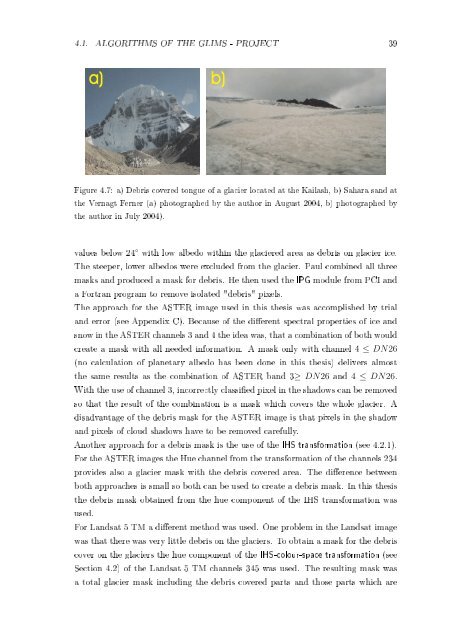
4.1. ALGORITHMS OF THE <strong>GLIMS</strong> - PROJECT 39a) b)Figure 4.7: a) Debris covered tongue of a glacier located at the Kailash, b) Sahara sand atthe Vernagt Ferner (a) photographed by the author in August 2004, b) photographed bythe author in July 2004).values below 24 ◦ with low albedo within the glaciered area as debris on glacier ice.The steeper, lower albedos were excluded <strong>from</strong> the glacier. Paul combined all threemasks and produced a mask for debris. He then used the IPG module <strong>from</strong> PCI anda Fortran program to remove isolated "debris" pixels.The approach for the ASTER image used in this thesis was accomplished by trialand error (see Appendix C). Because of the dierent spectral properties of ice andsnow in the ASTER channels 3 and 4 the idea was, that a combination of both wouldcreate a mask with all needed information. A mask only with channel 4 ≤ DN26(no calculation of planetary albedo has been done in this thesis) delivers almostthe same results as the combination of ASTER band 3≥ DN26 and 4 ≤ DN26.With the use of channel 3, incorrectly classied pixel in the shadows can be removedso that the result of the combination is a mask which covers the whole glacier. Adisadvantage of the debris mask for the ASTER image is that pixels in the shadowand pixels of cloud shadows have to be removed carefully.Another approach for a debris mask is the use of the IHS transformation (see 4.2.1).For the ASTER images the Hue channel <strong>from</strong> the transformation of the channels 234provides also a glacier mask with the debris covered area. The dierence betweenboth approaches is small so both can be used to create a debris mask. In this thesisthe debris mask obtained <strong>from</strong> the hue component of the IHS transformation wasused.For <strong>Land</strong>sat 5 TM a dierent method was used. One problem in the <strong>Land</strong>sat imagewas that there was very little debris on the glaciers. To obtain a mask for the debriscover on the glaciers the hue component of the IHS-colour-space transformation (seeSection 4.2) of the <strong>Land</strong>sat 5 TM channels 345 was used. The resulting mask wasa total glacier mask including the debris covered parts and those parts which are