2004-2006 Murat Avci
Durupinar's Great Telçeker Earthflow Geologic Formation
Durupinar's Great Telçeker Earthflow Geologic Formation

Create successful ePaper yourself
Turn your PDF publications into a flip-book with our unique Google optimized e-Paper software.
<strong>Murat</strong> <strong>Avci</strong> 437<br />
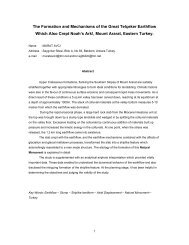
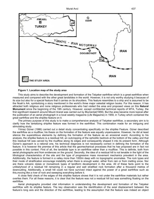
Figure 1. Location map of the study area<br />
This study aims to describe the development and formation of the Telçeker earthflow which is a great earthflow when<br />
measured and compared with the other great landslides in the world. However, it is not only worthy studying it because of<br />
its size but also for a special feature that it carries on its shoulders. This feature resembles to a ship and is assumed to be<br />
the Noah’s Ark, symbolizing a story mentioned in the world’s three major celestial religion books. For this reason, it has<br />
attracted both religious and none religious professionals who had visited the area and proposed views on this Natural<br />
Monument since the beginning of the 19th century. However, except confidential technical reports of MTA, Turkey, the<br />
first significant research around Mount Ararat was carried out by Blumental(1959). But the area became more topical after<br />
the publication of an aerial photograph in a local weekly magazine (Life Magazine) in 1959, in Turkey which contained the<br />
great earthflow and the shiplike feature on it.<br />
The primary purpose of this study is to make a comprehensive analysis of Telçeker earthflow, a secondary aim is to<br />
clarify how the tantalizing shiplike feature was formed in the earthflow. This combination made for an intriguing and<br />
stimulating study.<br />
Yılmaz Güner (1986) carried out a detail study concentrating specifically on the shiplike Feature. Güner described<br />
the earthflow as a mudflow; his thesis on the formation of the feature was equally unpersuasive. However, he did at least<br />
silence the superstitious elements by defining the formation of the feature as an erosional event. According to his<br />
analysis, the shiplike feature is a residiual hill, an outcropping of the ophiolitic bedrock at the bottom of the valley and that<br />
this residual hill was carved by the mudflow along its edges and consequently shaped it into its present form. Although<br />
Güner’s approach is a rational one, his technical diagnosis is not necessarily correct in defining the formation of the<br />
feature. It is however the premise of this article that the geomechanical processes that he has proposed are in fact not<br />
possible in this context. First of all, the landslide type is an earthflow rather than a mudflow. This is definite, both from<br />
aerial photographs and from evidences on the ground. Secondly, the idea of a residual hill is not tenable in the light of the<br />
lithological characteristics of the site and the type of progressive mass movement mechanics prevalent in the area.<br />
Additionally, the feature is formed in a valley more than 1000m deep with no topographic anomalies. The rock types and<br />
their mode of stratification encourage instability when there is enough water, either from rain or from melting snow. Nor<br />
are there volcanic dykes or monadnock types of landform development in the area. All of these facts point to the<br />
unlikelyhood of a residual hill remaining in a regular and well stratified rock formation after a thousand metres of<br />
downcutting. Additionally, a small hill could not have survived intact against the power of a great earthflow such as<br />
this,moving like a river of rock and sweeping everything before it.<br />
A close field check of the edges of the shiplike feature shows that it is not under the earthflow materials but rather<br />
overlies them. For all these reasons, it is clear that the feature was not a residual hill but was something floating on the<br />
earthflow.<br />
Aerial photographs provided vital information in understanding the development and formation of the Telçeker<br />
earthflow with its shiplike feature. The key observation was the identification of the axial displacement between the<br />
feature’s long axis and the direction of the earthflow, leading to the assumption that the feature was indeed an object