Juma Sustainable Development Reserve: The ... - The REDD Desk
Juma Sustainable Development Reserve: The ... - The REDD Desk
Juma Sustainable Development Reserve: The ... - The REDD Desk

You also want an ePaper? Increase the reach of your titles
YUMPU automatically turns print PDFs into web optimized ePapers that Google loves.
20<br />
Amazonas <strong>Sustainable</strong> Foundation<br />
Since these private areas do not belong to the State of Amazonas, they are excluded<br />
from the project, and the carbon contained in their forests will not be accounted.<br />
However, ongoing activities in these areas can impact the project area inside the reserve,<br />
and thus will receive special attention in the activities included in the monitoring<br />
plan.<br />
2.3 Deforestation<br />
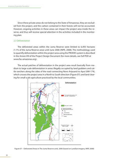
<strong>The</strong> deforested areas within the <strong>Juma</strong> <strong>Reserve</strong> were limited to 6,493 hectares<br />
(1.1% of the <strong>Juma</strong> <strong>Reserve</strong> area) until June 2006 (INPE, 2008). <strong>The</strong> methodology used<br />
to quantify deforestation within the project area using the PRODES system is described<br />
in the Annex VIII of the Project Design Document (for more details, see full PDD at<br />
www.fas-amazonas.org).<br />
<strong>The</strong> actual patches of deforestation in the project area result basically from medium<br />
to large scale deforestation in areas illegally occupied by land grabbers and cattle<br />
ranchers along the sides of the road connecting Novo Aripuanã to Apuí (AM-174),<br />
which crosses the project area in a North to South direction (Figure 07); and land clearing<br />
for small scale agriculture practiced by the local communities.<br />
Figure 07 – Deforested Areas in <strong>The</strong> <strong>Juma</strong> <strong>Reserve</strong> untiL 2006 (based on LandSat imagery, INPE 2008)