
You also want an ePaper? Increase the reach of your titles
YUMPU automatically turns print PDFs into web optimized ePapers that Google loves.
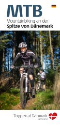
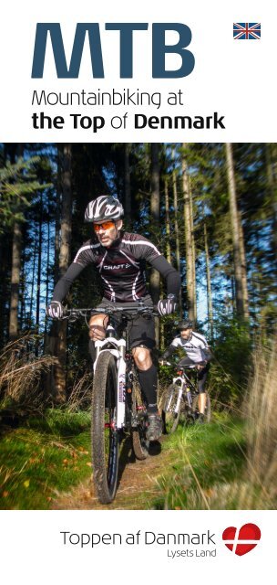
<strong>MTB</strong><br />
Mountainbiking at<br />
the Top of Denmark
2<br />
3<br />
Endless<br />
opportunities for<br />
<strong>MTB</strong><br />
adventures<br />
The Top of Denmark offers a wealth of opportunities<br />
for adventures by bike. <strong>MTB</strong> enthusiasts are prima rily<br />
drawn to the five tracks that have been constructed<br />
in the region. These tracks can be found in Skagen,<br />
Katsig (west of Frederikshavn), Sæby, Tornby and<br />
Bagterp on the southern outskirts of Hjørring. On<br />
the following pages you can find detailed descriptions<br />
of these tracks, which have all been laid out in<br />
forests and dune plantations.<br />
During the course of the year a number of races and events<br />
are held in which guests are also welcome to take part. See<br />
the list on page 17.<br />
In addition to the adrenalin kick offered by these dedicated<br />
<strong>MTB</strong> routes, you’re sure to want to try somewhat longer trips<br />
by mountain bike, whereby the element of competition is<br />
replaced by a sense of community and relaxed enjoyment<br />
– meaning there’s also time to enjoy the scenery and the<br />
attractive countryside. Several cycle routes of varying length<br />
are described on pages 12-15. Folders and maps are available<br />
at local tourist offices – see page 16 for more details.<br />
If you’re spontaneous and curious by nature, you’re probably<br />
quite happy to head off on your bike in the general direction<br />
of a landscape that suits you: Flat, undulating or hilly.<br />
There’s always a gravel track or a forest road that’ll take you<br />
away from the traffic on the highway and closer to nature.
4<br />
5<br />
5<br />
great<br />
tracks<br />
On a mountain bike you can be sure of a wealth<br />
of great adventures in the country side with<br />
family or friends. Whether you’re looking for<br />
thrills and a great form of exercise or just<br />
the chance to enjoy the beautiful scenery<br />
and the fresh air, the Top of Denmark boasts<br />
5 great tracks that have been laid out with<br />
degrees of difficulty to suit riders of all abilities.<br />
You can see the tracks at gpsies.com by<br />
searching under Username “Toppenafdanmark”.<br />
Tornby Klitplantage<br />
Sæbygaard Skov<br />
Katsig Bakker<br />
Bagterp Plantage<br />
Skagen Klitplantage
6<br />
7<br />
© OpenStreetMap-bidragsydere<br />
START/FINISH<br />
© OpenStreetMap-bidragsydere<br />
START/FINISH<br />
Tornby Klitplantage<br />
Skagen Klitplantage<br />
DEGREE OF DIFFICULTY:<br />
<br />
LENGTH OF TRACK: VERTICAL METRES:<br />
DEGREE OF DIFFICULTY: LENGTH OF TRACK: VERTICAL METRES:<br />
14 km. 180 m. 13.6 km. 44 m.<br />
The track runs between lakes, dunes and tall trees. The track is technically<br />
challenging for even the best riders. The entire route is single<br />
track with many tight bends and a view of Skagerrak. A fun route,<br />
and although there are relatively few vertical metres, you’re always<br />
either climbing or descending and there are several places where the<br />
route runs through sand. The track is well-maintained and you should<br />
follow the white arrows – at places you can follow the black route if<br />
you’re looking for an even greater challenge. The track has everything<br />
you could wish for – drops, steps, sandpits and explosive climbs.<br />
DIFFICULTY: For experienced riders.<br />
DIRECTION OF TRAVEL: The track should be ridden clockwise.<br />
STARTING POINT: Car park on Købstedvej in Tornby.<br />
GPS OF STARTING POINT: N 57°31.442’ E 9°56.288’<br />
Altitude (m)<br />
PROFILE:<br />
30<br />
20<br />
10<br />
0<br />
-10<br />
The <strong>MTB</strong> route runs through the eastern part of the dune plantation<br />
and takes in gravel tracks, sandy terrain and well-maintained stable<br />
surfaces. The route has a good flow, as well as a level of difficulty that<br />
allows beginners to enjoy it to the full. If you wish to ride through a<br />
rock garden, this is also an option. The area has only a few hills and<br />
the climbs are kept to a minimum, so everyone can enjoy cycling and<br />
the countryside at the same time.<br />
DIFFICULTY: For beginners and moderately experienced riders.<br />
DIRECTION OF TRAVEL: The track should be ridden clockwise.<br />
STARTING POINT: Car park at Skagen OK & Motion’s clubhouse,<br />
Gl. Landevej 47.<br />
GPS OF STARTING POINT: N 57°43.359’ E 10°33.153’<br />
PROFILE:<br />
Altitude (m)<br />
20<br />
15<br />
10<br />
5<br />
0<br />
0 1 2 3 4 5 6 7 8 9 10 11 12 13<br />
Distance (km)<br />
0 1 2 3 4 5 6 7 8 9 10 11 12 13 14<br />
Distance (km)
8<br />
9<br />
© OpenStreetMap-bidragsydere<br />
START/FINISH<br />
© OpenStreetMap-bidragsydere<br />
START/FINISH<br />
Sæbygaard Skov<br />
Katsig Bakker<br />
DEGREE OF DIFFICULTY:<br />
<br />
LENGTH OF TRACK: VERTICAL METRES:<br />
DEGREE OF DIFFICULTY: LENGTH OF TRACK: VERTICAL METRES:<br />
5.1 km. 75 m. 3.4 km. 144 m.<br />
The newly established <strong>MTB</strong> track in the forest at Sæbygård throws up<br />
challenges for both beginners and experienced mountain bike riders.<br />
The track is 5.1 km long and splits into two tracks at several points<br />
– with a white arrow for riders of all abilities and a red arrow for experienced<br />
riders. Wooden bridges have been established at several<br />
points on the track. A fast track with a good flow.<br />
DIFFICULTY: For moderately experienced riders.<br />
DIRECTION OF TRAVEL: The track should be ridden anticlockwise.<br />
STARTING POINT: Car park at Skovlyst.<br />
GPS OF STARTING POINT: N 57°20.315’ E 10°30.374<br />
The route in the hills of Katsig Bakker has many short, steep climbs,<br />
as well as a number of exciting descents and a rock garden. Practically<br />
the entire route is single track and there’s therefore not much time<br />
to relax, which makes the track that much more demanding.<br />
DIFFICULTY: For experienced riders.<br />
DIRECTION OF TRAVEL: The track should be ridden anticlockwise.<br />
STARTING POINT: 100 m west of the car park at the entrance<br />
to Skt. Jørgens Kilde.<br />
GPS OF STARTING POINT: N 57°26.981’ E 10°20.549’<br />
Altitude (m)<br />
PROFILE:<br />
25<br />
20<br />
15<br />
10<br />
5<br />
PROFILE:<br />
Altitude (m)<br />
85<br />
80<br />
75<br />
70<br />
65<br />
60<br />
55<br />
0,0 0,5 1,0 1,5 2,0<br />
2,5 3,0 3,5 4,0 4,5 5,0<br />
Distance (km)<br />
0,0 0,5 1,0 1,5 2,0 2,5 3,0 3,5 4,0<br />
Distance (km)
10<br />
DK-11<br />
START/FINISH<br />
© OpenStreetMap-bidragsydere<br />
Bagterp Plantage<br />
DEGREE OF DIFFICULTY: LENGTH OF TRACK: VERTICAL METRES:<br />
<br />
4.3 km.<br />
47 m.<br />
A fun track with countless bends running through a small plantation<br />
on the southern outskirts of Hjørring. The route doesn’t boast many<br />
vertical metres, but goes up and down all the time, and if you pick up<br />
the pace, the route presents a challenge for most riders. The track<br />
runs through different types of woodland.<br />
DIFFICULTY: For beginners and moderately experienced riders.<br />
DIRECTION OF TRAVEL: The track should be ridden anticlockwise.<br />
STARTING POINT: Car park at Aalborgvej.<br />
GPS OF STARTING POINT: N 57°26.421’ E 9°59.681’<br />
Good conduct<br />
on <strong>MTB</strong><br />
<br />
Ride only where you’re allowed<br />
• In the countryside you can only cycle on roads and tracks.<br />
• Do not ride on marked bridle paths, hiking trails, etc., off the<br />
forest roads.<br />
• Do not ride on ancient monuments, burial mounds, dykes<br />
and steps.<br />
• Do not ride in private forests from sunset until 6.00 a.m.<br />
the following morning.<br />
• You may ride on the beach – but not in the dunes.<br />
Ride responsibly<br />
• Adjust your speed and keep your distance – the highway<br />
code also applies in the countryside.<br />
• Do not cycle alone – remember your helmet, phone and<br />
European Health Insurance Card.<br />
• Do not ride on fragile tracks during very wet periods: use the<br />
robust tracks and forest roads. Only ride the <strong>MTB</strong> track in the<br />
direction specified.<br />
• Remember that you always ride at your own risk – the tracks<br />
are maintained on a regular basis, but their condition cannot<br />
be guaranteed, and unforeseen obstacles may appear.<br />
PROFILE:<br />
Altitude (m)<br />
45<br />
40<br />
35<br />
30<br />
25<br />
0,0 0,5 1,0 1,5 2,0 2,5 3,0 3,5 4,0<br />
Distance (km)<br />
Show consideration<br />
• Slow down when meeting other visitors in the forest. If you<br />
have a bell, use it in good time – or utter a verbal “ding-ding”.<br />
• Pay particular attention when encountering horses. Slow right<br />
down and make sure that the rider has seen you – particularly<br />
if approaching from the rear. The sound of squealing brakes<br />
frightens horses.<br />
• Do not drop litter in the countryside.
DK-12<br />
DK-13<br />
Other great<br />
cycling adventures<br />
in the region<br />
The <strong>MTB</strong> tracks represent only a fraction of the possibilities for<br />
cyclists at the Top of Denmark. A day on a mountain bike can<br />
take you further into the region to some of the other cycle routes<br />
or give you a chance to explore the region as a whole.<br />
On this and the following pages you can find a list of selected<br />
cycle routes in our region. They’re not actual <strong>MTB</strong> routes, but are<br />
still exciting. Some of the routes are marked and described in<br />
<strong>folder</strong>s, whilst others are simply sections of the dense network<br />
of gravel roads, gravel tracks and forest roads that link some of<br />
the properties scattered throughout the countryside. Information<br />
about these routes is available at local tourist offices, where<br />
you can also find maps and information about minor local routes.<br />
You can also find the routes at www.gpsies.com by searching<br />
under Username: “Toppenafdanmark”.<br />
Grøn tur (Green tour)<br />
An exciting and varied route of around 60 km in the area<br />
707<br />
around Frederikshavn which will take you through bogs,<br />
dunes, heaths, woods and river valleys – whilst at the same time<br />
running past burial mounds, manor houses and ancient monuments<br />
dating back to the Iron Age.<br />
I fiskens tegn (The sign of the fish)<br />
On this 35-km route you’ll have the sea as your companion,<br />
as well as cycling along the banks of streams and<br />
415<br />
over bridges. You’ll see fishing boats and a hive of activity at the<br />
harbour in Hirtshals, thus providing a stark contrast to the idyllic and<br />
peaceful stream of Uggerby Å, where patient anglers will be hoping<br />
to catch trout.<br />
Højt over havet (High above the sea)<br />
A 44-km cycle trip over some of Vendsyssel’s highest hilltops<br />
offering impressive views of the sea and the land.<br />
414<br />
From Hirtshals via Aabyen to Mygdal and onward to Tornby, before<br />
arriving back in Hirtshals.<br />
Rovfuglenes Rige<br />
(Kingdom of the birds of prey)<br />
416<br />
This 38-km trip at the headland of Skagens Odde runs<br />
through the kingdom of the birds of prey. The headland acts as a funnel<br />
for birds of prey on their migratory routes north during spring. Look<br />
up into the sky – you’re sure to catch sight of lots of buzzards, and<br />
perhaps also a white-tailed eagle or an osprey.
14<br />
15<br />
Østkystruten (East Coast Route)<br />
A section of the national cycle route along the coast<br />
5 from Skagen to Sønderborg. At the Top of Denmark<br />
the route runs past Aalbæk and its delightful harbour, the Bangsbo<br />
area, and the towns of Sæby and Voerså.<br />
Hærvejens cykelrute<br />
(Ancient Road Hærvejen’s cycle route)<br />
3<br />
The northernmost 31 km of Ancient Road Hærvejen’s<br />
cycle route takes you through attractive undulating landscape<br />
southwest of Frederikshavn, before running through flatter landscape,<br />
a former fjord arm, to Østervrå on the fringe of Jyske Ås.<br />
Tolneruten (Tolne route)<br />
Regional cycle route of 55 km that runs from Frederikshavn<br />
through Tolne and Sindal to Hjørring. It then<br />
62<br />
continues over the bridge crossing the stream of Liver Å to join<br />
the West Coast Route. The hilly landscape was formed during the<br />
last ice age.<br />
Bollerruten (Boller route)<br />
The Boller route is a 32-km regional cycle route that<br />
60<br />
links Ancient Road Hærvejen’s cycle route at Jyske<br />
Ås to the Tolne route at Hjørring. The route runs past the manor<br />
house at Boller Hovedgaard and through fertile farmland.<br />
Vestkystruten (West Coast Route)<br />
Running from Skagen to the German border, the<br />
1<br />
route is 560 km long. It runs via Tversted to Hirtshals,<br />
through inland dunes at the plantation of Tornby Klitplantage up<br />
over the cliff at Lønstrup and Rubjerg Knude to Løkken, before<br />
heading further south.
16<br />
17<br />
Practical info:<br />
IN THE EVENT OF EMERGENCY<br />
If you have an accident or meet someone who’s had an accident,<br />
you’ll need to call for help. In Denmark you need to use<br />
the European emergency number 112. Accidents on <strong>MTB</strong> usually<br />
occur out in the countryside, where it can be difficult to state<br />
an exact address. In this case, it’s vital that you either have a<br />
GPS that can specify the coordinates of your position or you<br />
can remember the name of the <strong>MTB</strong> track that you’re riding on.<br />
It’s always a good idea to have ID on you and preferably also<br />
a note with telephone numbers of your next of kin, as well as<br />
information about any conditions or allergies that the emergency<br />
services need to be aware of.<br />
How to find<br />
your way round<br />
the region<br />
The tourist offices at the Top of Denmark can help you with maps<br />
and brochures, as well as directions to the various tracks and routes.<br />
You can find the 5 <strong>MTB</strong> tracks described earlier and selected cycle<br />
routes in our region at www.gpsies.com. Under the “Discover” menu,<br />
you can select “Extended search” and write “Toppenafdanmark” in<br />
the “Username” field. Tracks and routes within the Top of Denmark<br />
region will then appear. You can also scan the QR code – this leads<br />
directly to the descriptions of the routes.<br />
GPSies is also available as an app for your<br />
smartphone, thus ensuring that you always<br />
have the information close at hand.<br />
Get the app at App-store or Google Play.<br />
The tracks can also be downloaded as files to your own GPS.<br />
RENTAL OF <strong>MTB</strong> CYCLES:<br />
Alfred Pedersens Eftf., Skagen<br />
www.cykelhandler.com, tel. +45 98 44 25 28<br />
Cykelgården Sæby<br />
www.cykelgaardensaeby.dk, tel. +45 98 46 14 10<br />
Hirtshals Cykeludlejning<br />
www.hirtshalscykler.dk, tel. +45 98 94 21 96<br />
Vendelbo Cykler, Hjørring<br />
www.vendelbocykler.dk, tel. +45 96 23 97 98<br />
Vittrup Cykeludlejning, Løkken<br />
www.vittrup-cykeludlejning.dk, tel. +45 42 71 71 26<br />
LINKS TO <strong>MTB</strong> EVENTS IN THE REGION:<br />
www.rødspætteløbet.dk<br />
www.coast2coast.nu<br />
www.nordicmtbrace.dk<br />
www.traedtil.dk<br />
<strong>MTB</strong> CLUBS IN THE REGION:<br />
Skagen <strong>MTB</strong>-klub: www.skagen-mtb.dk<br />
Sæby Motions Cykel Club: www.saebymcc.dk<br />
Aalbæk Cykelklub: www.aalbaekcykelklub.dk<br />
<strong>MTB</strong> Frederikshavn: www.mtb9900.dk<br />
Cycle Clubben Hjørring: www.cch-hj.dk<br />
The clubs can also be found on Facebook.
18<br />
19<br />
The 5 <strong>MTB</strong><br />
tracks at the<br />
Top of Denmark<br />
Kandestederne<br />
Råbjerg Mile<br />
Grenen<br />
Gl. Skagen<br />
SKAGEN<br />
SKAGEN KLITPLANTAGE<br />
Hulsig<br />
Tannis Bugt<br />
Skiveren<br />
Skagbanke<br />
Kattegat<br />
Hune<br />
KÅS<br />
Moseby<br />
tsminde<br />
Saltum<br />
Birkelse<br />
alvrimmen<br />
Rubjerg<br />
Knude<br />
PANDRUP<br />
LØNSTRUP<br />
Nr.Lyngby<br />
Vittrup<br />
LØKKEN<br />
Ingstrup<br />
V.Hjermitslev<br />
ÅBYBRO<br />
Skallerup<br />
Sønderlev<br />
Horne<br />
Tornby<br />
Vidstrup<br />
Vennebjerg<br />
HJØRRING<br />
Hundelev<br />
BAGTERP PLANTAGE<br />
Sr.Rubjerg/<br />
Gølstrup<br />
Vrensted<br />
Børglum<br />
Stenum<br />
Thise<br />
Ø.Hjermitslev<br />
BRØNDERSLEV<br />
BIERSTED<br />
HIRTSHALS<br />
TORNBY KLITPLANTAGE<br />
Nørlev<br />
TYLSTRUP<br />
NR.HALNE<br />
VADUM<br />
VRÅ<br />
Serritslev<br />
Tolstrup<br />
Sulsted<br />
VESTBJERG<br />
Uggerby<br />
Bjergby<br />
TVERSTED<br />
Mygdal<br />
Astrup<br />
Sønderskov<br />
Lørslev Ugilt<br />
Ilbro<br />
TÅRS<br />
Ø.Brønderslev<br />
Jerslev<br />
Hallund<br />
Hollensted<br />
Ørum<br />
Ravnstrup<br />
HJALLERUP<br />
VODSKOV<br />
Hørmested<br />
Hellum<br />
Glimsholt<br />
Sæsing<br />
Try<br />
SINDAL<br />
Brønden<br />
Tuen<br />
BINDSLEV<br />
ØSTERVRÅ<br />
Blæsbjerg<br />
Mosbjerg<br />
Vogn<br />
Morild<br />
Flauenskjold<br />
Tolne<br />
KATSIG BAKKER<br />
Lendum<br />
Try<br />
DYBVAD<br />
Rørholt<br />
Kvissel Elling<br />
Åsted<br />
Gærum<br />
Stenhøj<br />
Thorshøj<br />
Hørby<br />
Understed<br />
Karup<br />
Syvsten<br />
Aalbæk<br />
Jerup<br />
STRANDBY<br />
Lyngså<br />
Mølholt<br />
Præstbro<br />
Voerså<br />
Agersted<br />
DRONNINGLUND<br />
ASÅ<br />
Ålbæk Bugt<br />
Hirsholmene<br />
FREDERIKSHAVN<br />
SÆBY<br />
SÆBYGAARD SKOV
wizion.dk<br />
toppenafdanmark.dk<br />
tad@toppenafdanmark.dk<br />
www.facebook.com/toppenafdanmark