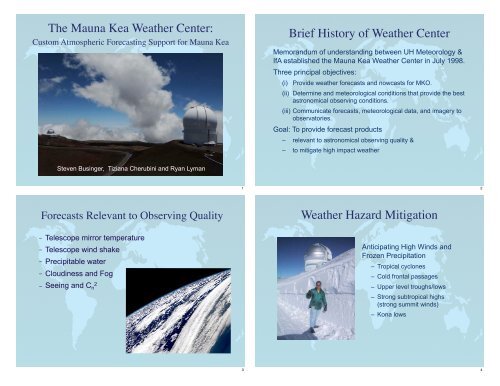
The Mauna Kea Weather Center: Brief History of Weather Center ...
The Mauna Kea Weather Center: Brief History of Weather Center ...
The Mauna Kea Weather Center: Brief History of Weather Center ...

You also want an ePaper? Increase the reach of your titles
YUMPU automatically turns print PDFs into web optimized ePapers that Google loves.
<strong>The</strong> <strong>Mauna</strong> <strong>Kea</strong> <strong>Weather</strong> <strong>Center</strong>:<br />
Custom Atmospheric Forecasting Support for <strong>Mauna</strong> <strong>Kea</strong><br />
Steven Businger, Tiziana Cherubini and Ryan Lyman<br />
Forecasts Relevant to Observing Quality<br />
– Telescope mirror temperature<br />
– Telescope wind shake<br />
– Precipitable water<br />
– Cloudiness and Fog<br />
– Seeing and C n 2<br />
1<br />
3<br />
<strong>Brief</strong> <strong>History</strong> <strong>of</strong> <strong>Weather</strong> <strong>Center</strong><br />
Memorandum <strong>of</strong> understanding between UH Meteorology &<br />
IfA established the <strong>Mauna</strong> <strong>Kea</strong> <strong>Weather</strong> <strong>Center</strong> in July 1998.<br />
Three principal objectives:<br />
(i) Provide weather forecasts and nowcasts for MKO.<br />
(ii) Determine and meteorological conditions that provide the best<br />
astronomical observing conditions.<br />
(iii) Communicate forecasts, meteorological data, and imagery to<br />
observatories.<br />
Goal: To provide forecast products<br />
– relevant to astronomical observing quality &<br />
– to mitigate high impact weather<br />
<strong>Weather</strong> Hazard Mitigation<br />
Anticipating High Winds and<br />
Frozen Precipitation<br />
– Tropical cyclones<br />
– Cold frontal passages<br />
– Upper level troughs/lows<br />
– Strong subtropical highs<br />
(strong summit winds)<br />
– Kona lows<br />
2<br />
4
Current Status<br />
MKWC forecasts issued twice daily, Monday through Friday<br />
Twice Daily <strong>Weather</strong> Research& Forecast (WRF) model runs<br />
Satellite and model graphics provided by web server(s)<br />
Comprehensive data archive developed & maintained<br />
Experience is accumulating in custom forecasting<br />
Research and development are ongoing<br />
Silicon Mechanics HPC<br />
<strong>The</strong> MKWC HPC system is comprised <strong>of</strong> 16 compute<br />
nodes, 128 CPUs (Intel Xeon L5420 Quad-Core 2.50GHz),<br />
with high-speed communication links between nodes<br />
(Infiniband cards and switches). <strong>The</strong> system includes a<br />
RAID-6 storage component.<br />
5<br />
7<br />
Two Linux Servers provide<br />
– Data ingest<br />
mkwc.ifa.hawaii.edu<br />
– Data assimilation and WRF input<br />
– Graphic/Web<br />
– Redundant product distribution<br />
– Archive function<br />
Key Variables in Twice-Daily<br />
MKWC Forecasts<br />
Cloud cover, fog,<br />
precipitation<br />
Summit winds and<br />
temperature<br />
Precipitable water<br />
Seeing, Cn 2 , and wind<br />
pr<strong>of</strong>iles<br />
6<br />
8
Seeing Verification using MKAM<br />
Data: March to August, 8 hours (8pm to 4am HST), nightly averages<br />
0 < wind speed < 5<br />
5 < wind speed < 10<br />
10 < wind speed < 15<br />
15 < wind speed < 20<br />
wind speed > 20<br />
Tendency to overestimate episodes <strong>of</strong> higher<br />
surface wind speed under stable conditions.<br />
00, night 1 12, night 1<br />
Transitional “bubble” <strong>of</strong> turbulence<br />
By eliminating these cases from the dataset: RMS = 0.28 and<br />
CORR = 0.7<br />
Seeing Verification using MKAM<br />
June 13/14, 2010 (HST)<br />
Another example <strong>of</strong> a night<br />
when WRF prediction<br />
underestimate the observed<br />
seeing.<br />
17<br />
19<br />
Seeing Verification using MKAM<br />
July 26/27, 2010 (HST)<br />
Example <strong>of</strong> a night when WRF<br />
prediction underestimated the<br />
observed seeing: a temporary<br />
increase in the winds in the<br />
boundary layer stir up a “bubble”<br />
<strong>of</strong> turbulence that the model does<br />
not resolve… perhaps due to lack<br />
<strong>of</strong> spatial or temporal resolution.<br />
Seeing Verification using MKAM<br />
<strong>The</strong> dates corresponding to cases <strong>of</strong> “large” overestimation<br />
have all in common the same synoptic scenario:<br />
– Strong large scale subsidence ! very stable atmosphere<br />
– Strong/tight surface pressure gradients resulting in moderate to<br />
high winds at the summit (wind speed > 15-18 mph).<br />
<strong>The</strong> atmospheric stability does not allow turbulence to<br />
develop, therefore good/average seeing is observed.<br />
WRF generates more turbulence than it should as a<br />
consequence <strong>of</strong> the high surface winds ! skew in the<br />
scatterplot.<br />
18<br />
20
Seeing Calibration using MKAM<br />
Third Calibration – Current E min pr<strong>of</strong>ile<br />
Calibration <strong>of</strong> the background TKE (E min) is performed for each<br />
integral layer (6 MASS layers + 1 GL layer):<br />
Synergy with Meteorology Community<br />
21<br />
23<br />
Seeing Calibration using MKAM<br />
Statistics have been run for the two nights <strong>of</strong> each WRF<br />
cycle verifying the MKAM observations. Data are nightly<br />
averaged: 8 hours from 8pm to 4am HST.<br />
Second calibration – Jun to Aug<br />
00 UTC cycle 12 UTC cycle<br />
N1 N2 N1 N2<br />
RMS 0.33 0.34 0.34 0.35<br />
CORR 0.62 0.63 0.60 0.60<br />
Synergy with Meteorology Community<br />
WRF is a community-supported research and forecast model.<br />
NSF and NOAA funding – yearly updates and improvements.<br />
Local Analysis and Prediction System (LAPS) data assimilation<br />
application for WRF developed in collaboration with NOAA ESRL.<br />
Unidata provides much <strong>of</strong> the input data for LAPS/WRF and the<br />
web distribution s<strong>of</strong>tware used by MKWC.<br />
– Satellite derived atmospheric motion vectors (e.g., cloud drift<br />
winds) from UW CIMSS.<br />
– COSMIC Satellite Constellation: refractivity data from limbsoundings<br />
– National <strong>Center</strong> for Atmospheric Research<br />
– GPS IPW in collaboration with UH Geophysics and NOAA.<br />
– Calibration and assimilation <strong>of</strong> lightning data in collaboration<br />
with ONR and NASA.<br />
Vog Measurement and Prediction (VMAP) Project<br />
22<br />
24
Vog Measurement and Prediction<br />
VMAP project is facilitated by MKWC. See<br />
http://mkwc.ifa.hawaii.edu/vmap/index.cgi<br />
Sulfate Aerosol Animation<br />
25<br />
27<br />
Sulfur Dioxide Animation<br />
New Synergy<br />
New Post Doctoral Fellow started this Jan – will tackle a broader WRF<br />
verification effort as part <strong>of</strong> a project to use WRF output in an ecology study<br />
funded by an NSF water resources management grant.<br />
NOAA is funding a satellite x-band downlink that will bring NASA and NOAA<br />
POES data to UH. Project related to launch <strong>of</strong> GOES-R satellite in 2016.<br />
– MODIS<br />
– AQUA<br />
– AIRS<br />
– TRMM<br />
– POES<br />
– DMS<br />
26<br />
28
MKWC Future Work<br />
Increase spatial and temporal resolution <strong>of</strong> WRF<br />
– challenge here is to overcome numerical instability due<br />
to forcing from terrain at scale <strong>of</strong> grid resolution.<br />
Implement WRF Variational Data Assimilation<br />
Textbook Now Available<br />
29<br />
31<br />
MKWC Future Work<br />
• Increase the skill <strong>of</strong> conventional and seeing forecasts<br />
with help <strong>of</strong> validation statistics.<br />
• Provide forecast variables with finer temporal and<br />
spatial resolution.<br />
• Issue longer-term seeing forecasts.<br />
• Proposal to expand MKWC service to Chile.<br />
Introduction (Businger)<br />
Seeing Clearly<br />
1. Atmospheric Turbulence Authors<br />
1.1 Atmospheric turbulence from the perspective <strong>of</strong> a meteorologist………….………………..(Raman)<br />
1.2 Atmospheric turbulence for astronomy……………………………………………..………..….(Vernin)<br />
2. Instrumentation for Observing Optical Turbulence<br />
2.1 Remote optical turbulence sensing: present and future………………………….………..(Tokovinin)<br />
2.2 Standard and commonly used optical turbulence pr<strong>of</strong>ilers ……….……………..………(Chun et al.)<br />
2.3 Seeing by site monitors versus VLT image quality ………………………….………...(Sarazin et al.)<br />
3. Adaptive Optics - Interferometry<br />
3.1 Introduction to Adaptive Optics: <strong>The</strong> Quest for Image Quality……….…...(Tokovinin and Businger)<br />
4. Modeling Optical Turbulence<br />
4.1 <strong>The</strong> “Missing Link” Between Meteorology and Astronomy…………………………...(Simons & Roy)<br />
4.2 Optical Turbulence Modeling and Forecast.<br />
Towards a new era for ground-based astrononmy………………….……………………….(Masciadri)<br />
4.3 An operational perspective for modeling optical turbulence…......(Cheribini, Businger, and Lyman)<br />
30<br />
32
Questions?<br />
33