Maine Department of Transportation Caribou Connector ... - Maine.gov
Maine Department of Transportation Caribou Connector ... - Maine.gov
Maine Department of Transportation Caribou Connector ... - Maine.gov

You also want an ePaper? Increase the reach of your titles
YUMPU automatically turns print PDFs into web optimized ePapers that Google loves.
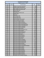
<strong>Caribou</strong> 6462.30<br />
Alignment Option 2, shown on Figure 2-6, includes an upgrade <strong>of</strong> 0.35 miles <strong>of</strong> Route 1 beginning at<br />
the High Street intersection north to the Route 89 intersection. It then diverges from Route 1 and<br />
extends north through a mix <strong>of</strong> agricultural land and forest east <strong>of</strong> the Cary Medical Center. It then<br />
swings west, crossing Route 1 and more open, agricultural land and forest before intersecting with<br />
Route 161 near Ogren Road at the <strong>Caribou</strong>-Woodland municipal boundary.<br />
Alignment Option 2 includes 4.8 miles <strong>of</strong> new-alignment highway and 0.35 miles <strong>of</strong> existing highway<br />
reconstruction, including a 0.16-mile section <strong>of</strong> Route 161 that would be upgraded at the intersection<br />
<strong>of</strong> Route 161 and the Route 1-161 <strong>Connector</strong>.<br />
Alignment Option 2 has the second highest amount <strong>of</strong> wetland impact (20 acres) <strong>of</strong> the alignment<br />
options considered and substantial farmland impacts (54 acres). It would result in the loss <strong>of</strong> 7<br />
commercial and 15 residential properties, with potentially severe economic consequences to the City<br />
<strong>of</strong> <strong>Caribou</strong>.<br />
Alignment Option 2 was dismissed from consideration because, although it would satisfy the<br />
transportation elements <strong>of</strong> the NEPA Purpose and Need, it is not practicable because the City <strong>of</strong><br />
<strong>Caribou</strong> opposes the commercial property and business impacts, and has substantial environmental<br />
impacts to non-aquatic resources (see Table 3-2, below). Other alignment options retained for<br />
consideration would satisfy the transportation elements <strong>of</strong> the NEPA Purpose and Need with less<br />
impact to aquatic resources and other natural and social environmental resources.<br />
Alignment Option 3<br />
Alignment Option 3, shown on Figure 2-6, is on primarily new alignment. It includes an upgrade <strong>of</strong><br />
Route 1 along an approximately 0.11 mile long section then extends along new alignment northeast<br />
roughly parallel to the Montreal, <strong>Maine</strong>, and Atlantic (MM&A) railway before swinging northwest,<br />
crossing Route 89, and traveling along 1.2 miles <strong>of</strong> the Bangor-Aroostook Trail (a publicly-owned trail<br />
along a former rail line used by ATVs and snowmachines), crossing predominantly undeveloped<br />
forest; crossing Route 1, and then traversing farmlands and forest before intersecting with Route 161<br />
near Ogren Road at the <strong>Caribou</strong>-Woodland municipal boundary along the same alignment as<br />
Alignment Option 2.<br />
Alignment Option 3 includes 5.4 miles <strong>of</strong> new-alignment highway and 0.27 miles <strong>of</strong> existing highway<br />
reconstruction, including the upgrade <strong>of</strong> a 0.16-mile section <strong>of</strong> Route 161 at the intersection <strong>of</strong> Route<br />
161 and the Route 1-161 <strong>Connector</strong> and 0.11 miles <strong>of</strong> Route 1 at the south end <strong>of</strong> the <strong>Connector</strong>.<br />
As seen on Table 3-2 (below), Alignment Option 3 has the highest amount <strong>of</strong> wetland impact (22<br />
acres) <strong>of</strong> the alignment options considered and substantial farmland impacts (49 acres). It would<br />
result in the loss <strong>of</strong> 5 commercial and 12 residential properties, with potentially severe economic<br />
consequences to the City <strong>of</strong> <strong>Caribou</strong>.<br />
Alignment Option 3 was dismissed from consideration because, although Alignment Option 3 satisfies<br />
the transportation elements <strong>of</strong> the NEPA Purpose and Need and is practicable, it would result in the<br />
greatest impact to wetlands (22 acres) <strong>of</strong> the alignment options considered. There are other<br />
alternatives under consideration that would have less wetland impact and would be less<br />
environmentally damaging.