2007 Spring

You also want an ePaper? Increase the reach of your titles
YUMPU automatically turns print PDFs into web optimized ePapers that Google loves.
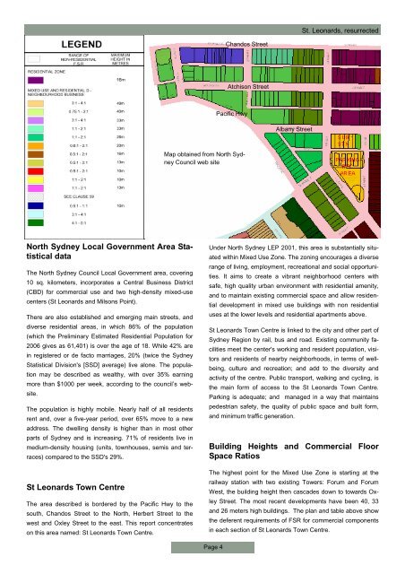
St. Leonards, resurrected<br />
Chandos Street<br />
Atchison Street<br />
Pacific Hwy<br />
Albany Street<br />
Map obtained from North Sydney<br />
Council web site<br />
North Sydney Local Government Area Statistical<br />
data<br />
The North Sydney Council Local Government area, covering<br />
10 sq. kilometers, incorporates a Central Business District<br />
(CBD) for commercial use and two high-density mixed-use<br />
centers (St Leonards and Milsons Point).<br />
There are also established and emerging main streets, and<br />
diverse residential areas, in which 86% of the population<br />
(which the Preliminary Estimated Residential Population for<br />
2006 gives as 61,401) is over the age of 18. While 42% are<br />
in registered or de facto marriages, 20% (twice the Sydney<br />
Statistical Division's [SSD] average) live alone. The population<br />
may be described as wealthy, with over 35% earning<br />
more than $1000 per week, according to the council’s website.<br />
The population is highly mobile. Nearly half of all residents<br />
rent and, over a five-year period, over 65% move to a new<br />
address. The dwelling density is higher than in most other<br />
parts of Sydney and is increasing. 71% of residents live in<br />
medium-density housing (units, townhouses, semis and terraces)<br />
compared to the SSD's 29%.<br />
St Leonards Town Centre<br />
The area described is bordered by the Pacific Hwy to the<br />
south, Chandos Street to the North, Herbert Street to the<br />
west and Oxley Street to the east. This report concentrates<br />
on this area named: St Leonards Town Centre.<br />
Under North Sydney LEP 2001, this area is substantially situated<br />
within Mixed Use Zone. The zoning encourages a diverse<br />
range of living, employment, recreational and social opportunities.<br />
It aims to create a vibrant neighborhood centers with<br />
safe, high quality urban environment with residential amenity,<br />
and to maintain existing commercial space and allow residential<br />
development in mixed use buildings with non residential<br />
uses at the lower levels and residential apartments above.<br />
St Leonards Town Centre is linked to the city and other part of<br />
Sydney Region by rail, bus and road. Existing community facilities<br />
meet the center's working and resident population, visitors<br />
and residents of nearby neighborhoods, in terms of wellbeing,<br />
culture and recreation; and add to the diversity and<br />
activity of the centre. Public transport, walking and cycling, is<br />
the main form of access to the St Leonards Town Centre.<br />
Parking is adequate; and managed in a way that maintains<br />
pedestrian safety, the quality of public space and built form,<br />
and minimum traffic generation.<br />
Building Heights and Commercial Floor<br />
Space Ratios<br />
The highest point for the Mixed Use Zone is starting at the<br />
railway station with two existing Towers: Forum and Forum<br />
West, the building height then cascades down to towards Oxley<br />
Street. The most recent developments have been 40, 33<br />
and 26 meters high buildings. The plan and table above show<br />
the deferent requirements of FSR for commercial components<br />
in each section of St Leonards Town Centre.<br />
Page 4