Archaeology in Northumberland
Celebrating 25 years of Archaeology in Northumberland
Celebrating 25 years of Archaeology in Northumberland

You also want an ePaper? Increase the reach of your titles
YUMPU automatically turns print PDFs into web optimized ePapers that Google loves.
logy – 1990-2015<br />
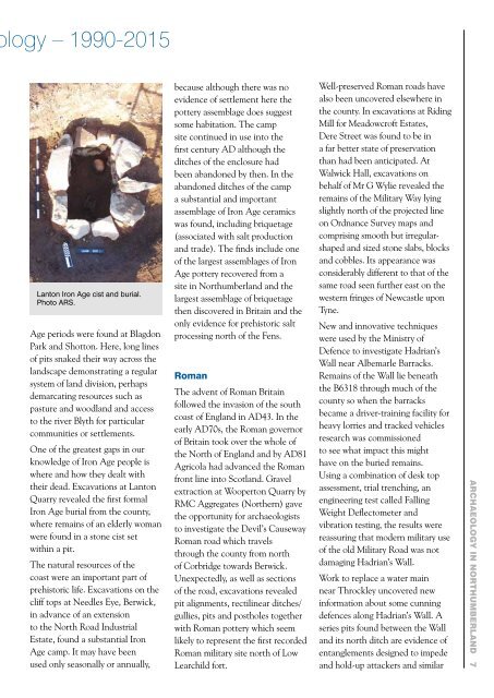
Lanton Iron Age cist and burial.<br />
Photo ARS.<br />
Age periods were found at Blagdon<br />
Park and Shotton. Here, long l<strong>in</strong>es<br />
of pits snaked their way across the<br />
landscape demonstrat<strong>in</strong>g a regular<br />
system of land division, perhaps<br />
demarcat<strong>in</strong>g resources such as<br />
pasture and woodland and access<br />
to the river Blyth for particular<br />
communities or settlements.<br />
One of the greatest gaps <strong>in</strong> our<br />
knowledge of Iron Age people is<br />
where and how they dealt with<br />
their dead. Excavations at Lanton<br />
Quarry revealed the first formal<br />
Iron Age burial from the county,<br />
where rema<strong>in</strong>s of an elderly woman<br />
were found <strong>in</strong> a stone cist set<br />
with<strong>in</strong> a pit.<br />
The natural resources of the<br />
coast were an important part of<br />
prehistoric life. Excavations on the<br />
cliff tops at Needles Eye, Berwick,<br />
<strong>in</strong> advance of an extension<br />
to the North Road Industrial<br />
Estate, found a substantial Iron<br />
Age camp. It may have been<br />
used only seasonally or annually,<br />
because although there was no<br />
evidence of settlement here the<br />
pottery assemblage does suggest<br />
some habitation. The camp<br />
site cont<strong>in</strong>ued <strong>in</strong> use <strong>in</strong>to the<br />
first century AD although the<br />
ditches of the enclosure had<br />
been abandoned by then. In the<br />
abandoned ditches of the camp<br />
a substantial and important<br />
assemblage of Iron Age ceramics<br />
was found, <strong>in</strong>clud<strong>in</strong>g briquetage<br />
(associated with salt production<br />
and trade). The f<strong>in</strong>ds <strong>in</strong>clude one<br />
of the largest assemblages of Iron<br />
Age pottery recovered from a<br />
site <strong>in</strong> <strong>Northumberland</strong> and the<br />
largest assemblage of briquetage<br />
then discovered <strong>in</strong> Brita<strong>in</strong> and the<br />
only evidence for prehistoric salt<br />
process<strong>in</strong>g north of the Fens.<br />
Roman<br />
The advent of Roman Brita<strong>in</strong><br />
followed the <strong>in</strong>vasion of the south<br />
coast of England <strong>in</strong> AD43. In the<br />
early AD70s, the Roman governor<br />
of Brita<strong>in</strong> took over the whole of<br />
the North of England and by AD81<br />
Agricola had advanced the Roman<br />
front l<strong>in</strong>e <strong>in</strong>to Scotland. Gravel<br />
extraction at Wooperton Quarry by<br />
RMC Aggregates (Northern) gave<br />
the opportunity for archaeologists<br />
to <strong>in</strong>vestigate the Devil’s Causeway<br />
Roman road which travels<br />
through the county from north<br />
of Corbridge towards Berwick.<br />
Unexpectedly, as well as sections<br />
of the road, excavations revealed<br />
pit alignments, rectil<strong>in</strong>ear ditches/<br />
gullies, pits and postholes together<br />
with Roman pottery which seem<br />
likely to represent the first recorded<br />
Roman military site north of Low<br />
Learchild fort.<br />
Well-preserved Roman roads have<br />
also been uncovered elsewhere <strong>in</strong><br />
the county. In excavations at Rid<strong>in</strong>g<br />
Mill for Meadowcroft Estates,<br />
Dere Street was found to be <strong>in</strong><br />
a far better state of preservation<br />
than had been anticipated. At<br />
Walwick Hall, excavations on<br />
behalf of Mr G Wylie revealed the<br />
rema<strong>in</strong>s of the Military Way ly<strong>in</strong>g<br />
slightly north of the projected l<strong>in</strong>e<br />
on Ordnance Survey maps and<br />
compris<strong>in</strong>g smooth but irregularshaped<br />
and sized stone slabs, blocks<br />
and cobbles. Its appearance was<br />
considerably different to that of the<br />
same road seen further east on the<br />
western fr<strong>in</strong>ges of Newcastle upon<br />
Tyne.<br />
New and <strong>in</strong>novative techniques<br />
were used by the M<strong>in</strong>istry of<br />
Defence to <strong>in</strong>vestigate Hadrian’s<br />
Wall near Albemarle Barracks.<br />
Rema<strong>in</strong>s of the Wall lie beneath<br />
the B6318 through much of the<br />
county so when the barracks<br />
became a driver-tra<strong>in</strong><strong>in</strong>g facility for<br />
heavy lorries and tracked vehicles<br />
research was commissioned<br />
to see what impact this might<br />
have on the buried rema<strong>in</strong>s.<br />
Us<strong>in</strong>g a comb<strong>in</strong>ation of desk top<br />
assessment, trial trench<strong>in</strong>g, an<br />
eng<strong>in</strong>eer<strong>in</strong>g test called Fall<strong>in</strong>g<br />
Weight Deflectometer and<br />
vibration test<strong>in</strong>g, the results were<br />
reassur<strong>in</strong>g that modern military use<br />
of the old Military Road was not<br />
damag<strong>in</strong>g Hadrian’s Wall.<br />
Work to replace a water ma<strong>in</strong><br />
near Throckley uncovered new<br />
<strong>in</strong>formation about some cunn<strong>in</strong>g<br />
defences along Hadrian’s Wall. A<br />
series pits found between the Wall<br />
and its north ditch are evidence of<br />
entanglements designed to impede<br />
and hold-up attackers and similar<br />
<strong>Archaeology</strong> <strong>in</strong> <strong>Northumberland</strong> 7