

SUSTAINABILITY
dx6L306WkZQ
dx6L306WkZQ

You also want an ePaper? Increase the reach of your titles
YUMPU automatically turns print PDFs into web optimized ePapers that Google loves.
SANCTUARY<br />
Feature<br />
Maritime Environmental Protection<br />
Guidance for Royal Navy operators at sea<br />
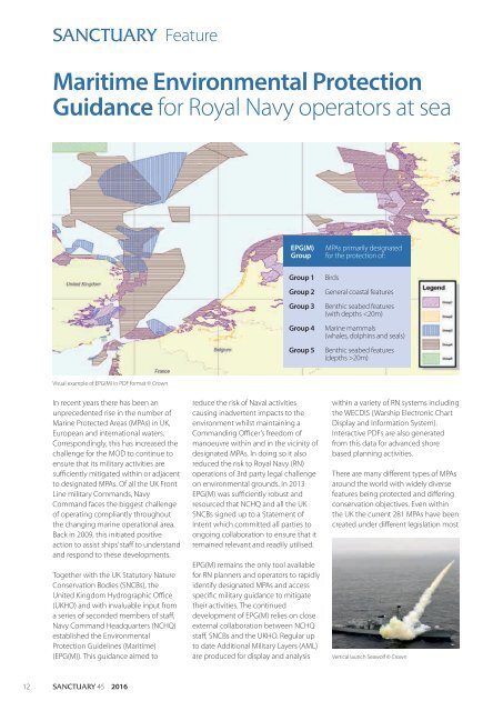
EPG(M)<br />
Group<br />
Group 1<br />
Group 2<br />
Group 3<br />
Group 4<br />
Group 5<br />
MPAs primarily designated<br />
for the protection of:<br />
Birds<br />
General coastal features<br />
Benthic seabed features<br />
(with depths 20m)<br />
Visual example of EPG(M) in PDF format © Crown<br />
In recent years there has been an<br />
unprecedented rise in the number of<br />
Marine Protected Areas (MPAs) in UK,<br />
European and international waters.<br />
Correspondingly, this has increased the<br />
challenge for the MOD to continue to<br />
ensure that its military activities are<br />
sufficiently mitigated within or adjacent<br />
to designated MPAs. Of all the UK Front<br />
Line military Commands, Navy<br />
Command faces the biggest challenge<br />
of operating compliantly throughout<br />
the changing marine operational area.<br />
Back in 2009, this initiated positive<br />
action to assist ships’ staff to understand<br />
and respond to these developments.<br />
Together with the UK Statutory Nature<br />
Conservation Bodies (SNCBs), the<br />
United Kingdom Hydrographic Office<br />
(UKHO) and with invaluable input from<br />
a series of seconded members of staff,<br />
Navy Command Headquarters (NCHQ)<br />
established the Environmental<br />
Protection Guidelines (Maritime)<br />
(EPG(M)). This guidance aimed to<br />
reduce the risk of Naval activities<br />
causing inadvertent impacts to the<br />
environment whilst maintaining a<br />
Commanding Officer’s freedom of<br />
manoeuvre within and in the vicinity of<br />
designated MPAs. In doing so it also<br />
reduced the risk to Royal Navy (RN)<br />
operations of 3rd party legal challenge<br />
on environmental grounds. In 2013<br />
EPG(M) was sufficiently robust and<br />
resourced that NCHQ and all the UK<br />
SNCBs signed up to a Statement of<br />
Intent which committed all parties to<br />
ongoing collaboration to ensure that it<br />
remained relevant and readily utilised.<br />
EPG(M) remains the only tool available<br />
for RN planners and operators to rapidly<br />
identify designated MPAs and access<br />
specific military guidance to mitigate<br />
their activities. The continued<br />
development of EPG(M) relies on close<br />
external collaboration between NCHQ<br />
staff, SNCBs and the UKHO. Regular up<br />
to date Additional Military Layers (AML)<br />
are produced for display and analysis<br />
within a variety of RN systems including<br />
the WECDIS (Warship Electronic Chart<br />
Display and Information System).<br />
Interactive PDFs are also generated<br />
from this data for advanced shore<br />
based planning activities.<br />
There are many different types of MPAs<br />
around the world with widely diverse<br />
features being protected and differing<br />
conservation objectives. Even within<br />
the UK the current 281 MPAs have been<br />
created under different legislation most<br />
Vertical launch Seawolf © Crown<br />
12<br />
SANCTUARY 45 2016