

A new urban paradigm pathways to sustainable development
PiF37
PiF37

Create successful ePaper yourself
Turn your PDF publications into a flip-book with our unique Google optimized e-Paper software.
Iraq, Pakistan, Syria and Yemen as well as<br />
the Democratic Republic of the Congo,<br />
Nigeria and South Africa. The data<br />
visualisation suggests that there are at<br />
least as many cities ranking high on the<br />
fragility scale (scoring 3–4) in high- and<br />
upper-middle-income settings as in<br />
lower-middle- and low-incomes ones.<br />
Third, fragile cities are not confined <strong>to</strong><br />
countries wrecked by armed conflict. There<br />
were roughly 40 war-affected (UCDP 2016)<br />
and 33 fragile states in 2015. 5 There is little<br />
doubt that cities in countries such as Iraq,<br />
South Sudan or Syria are especially at risk<br />
of instability. But cities in these countries<br />
are not the only ones at high risk.<br />
Fourth, it is not necessarily the largest<br />
cities that are most susceptible <strong>to</strong> fragility.<br />
Rather, it is smaller and medium-sized<br />
cities that are most at risk. The data<br />
visualisation demonstrates that just three<br />
megacities (over 10 million people) and<br />
three very large cities (with between 5<br />
and 10 million people) are at high risk of<br />
fragility (3–4 on the scale). These include<br />
Baghdad, Dar es Salaam, Johannesburg,<br />
Karachi, Lagos and Shanghai. But there<br />
are another 56 large cities (1–5 million<br />
people), 42 medium cities (500,000–<br />
1 million people) and 40 smaller cities<br />
(250,000–500,000 people) that are<br />
classified as ‘fragile’.<br />
Fifth, the fastest growing cities appear<br />
<strong>to</strong> be especially vulnerable <strong>to</strong> fragility.<br />
Most cities around the world are growing<br />
at between 0 and 3 per cent. The data<br />
visualisation detects 87 cities—most of<br />
them in the rust belt of the USA, in the<br />
UK, France, Germany, Russia, Ukraine<br />
and parts of China—that are shrinking<br />
in size (Igarapé Institute 2016). Yet the<br />
most-at-risk cities are those that are<br />
growing at a pace of 4 per cent or more.<br />
The risks are especially prominent<br />
in sub-Saharan Africa, the Middle<br />
East and South and East Asia, where<br />
the vast majority of future city<br />
population growth is projected.<br />
Sixth, the most violent cities in the<br />
world are not where you think they are.<br />
While some research organisations rank<br />
cities according <strong>to</strong> homicide rates, their<br />
assessments are often heavily biased due<br />
<strong>to</strong> variations in reporting (Economist 2016).<br />
The fragile cities data visualisation tracks<br />
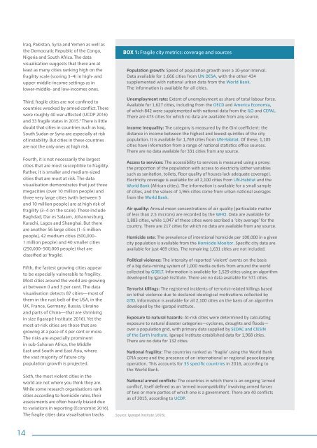
BOX 1: Fragile city metrics: coverage and sources<br />
Population growth: Speed of population growth over a 10-year interval.<br />
Data available for 1,666 cities from UN DESA, with the other 434<br />
supplemented with national <strong>urban</strong> data from the World Bank.<br />
The information is available for all cities.<br />
Unemployment rate: Extent of unemployment as share of <strong>to</strong>tal labour force.<br />
Available for 1,627 cities, including from the OECD and America Economia,<br />
of which 842 were supplemented with national data from the ILO and CEPAL.<br />
There are 473 cities for which no data are available from any source.<br />
Income inequality: The category is measured by the Gini coefficient: the<br />
distance in income between the highest and lowest quintiles of the city<br />
population. It is available for 1,769 cities from UN-Habitat. Of these, 1,105<br />
cities have information from a range of national statistics office sources.<br />
There are no data available for 331 cities from any source.<br />
Access <strong>to</strong> services: The accessibility <strong>to</strong> services is measured using a proxy:<br />
the proportion of the population with access <strong>to</strong> electricity (other variables<br />
such as sanitation, <strong>to</strong>ilets, floor quality of houses lack adequate coverage).<br />
Electricity coverage is available for all 2,100 cities from UN-Habitat and the<br />
World Bank (African cities). The information is available for a small sample<br />
of cities, and the values of 1,965 cities come from <strong>urban</strong> national averages<br />
from the World Bank.<br />
Air quality: Annual mean concentrations of air quality (particulate matter<br />
of less than 2.5 microns) are recorded by the WHO. Data are available for<br />
1,883 cities, while 1,047 of these cities were ascribed a ‘city average’ for the<br />
country. There are 217 cities for which no data are available from any source.<br />
Homicide rate: The prevalence of intentional homicide per 100,000 in a given<br />
city population is available from the Homicide Moni<strong>to</strong>r. Specific city data are<br />
available for just 469 cities. The remaining 1,631 cities are not included.<br />
Political violence: The intensity of reported ‘violent’ events on the basis<br />
of a big data-mining system of 1,000 media outlets from around the world<br />
collected by GDELT. Information is available for 1,529 cities using an algorithm<br />
developed by Igarapé Institute. There are no data available for 571 cities.<br />
Terrorist killings: The registered incidents of terrorist-related killings based<br />
on lethal violence due <strong>to</strong> declared ideological motivations collected by<br />
GTD. Information is available for all 2,100 cities on the basis of an algorithm<br />
developed by the Igarapé Institute.<br />
Exposure <strong>to</strong> natural hazards: At-risk cities were determined by calculating<br />
exposure <strong>to</strong> natural disaster categories—cyclones, droughts and floods—<br />
over a population grid, with primary data supplied by SEDAC and CIESIN<br />
of the Earth Institute. Igarapé Institute established data for 1,968 cities.<br />
There are no data for 132 cities.<br />
National fragility: The countries ranked as ‘fragile’ using the World Bank<br />
CPIA score and the presence of an international or regional peacekeeping<br />
operation. This accounts for 33 specific countries in 2016, according <strong>to</strong><br />
the World Bank.<br />
National armed conflicts: The countries in which there is an ongoing ‘armed<br />
conflict’, itself defined as an ‘armed incompatibility’ involving armed forces<br />
of two or more parties of which one is a government. There are 40 conflicts<br />
as of 2015, according <strong>to</strong> UCDP.<br />
Source: Igarapé Institute (2016).<br />
14