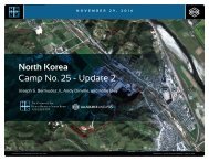
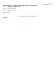
H R N K CAMP NO. 25 Figure 19 Entrance Entrance and checkpoint Furniture factory and lumberyard Prisoner housing Entrance Probable leadership memorial hall Water treatment Light industry Guard barracks Entrance Headquarters and administration Entrance Main entrance and checkpoint Agricultural and livestock support area Reported crematorium Possible processing plant Terraced orchards 0 200 m Central Compound and Administrative Areas, September 21, 2015. (41.833 N, 129.727 E) COPYRIGHT ©ALLSOURCE ANALYSIS, INC. 2016 COPYRIGHT © 2015 BY DIGITALGLOBE, INC., SEPTEMBER 21, 2015 24 BACK
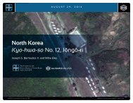
H R N K CH’OMA-BONG CAMP RESTRICTED NO. 25 AREA North Korea: Imagery Analysis of Camp No. 25 - Update 2 Immediately outside the western corner of the central camp, and sharing one of its walls, is a small walled-in area that escapees describe as a crematory. 10 Agriculture Areas Located within the camp’s perimeter are approximately 79 hectares (0.3 square miles) of cultivated fields of grain crops immediately north of the central camp and orchards on the hillsides to the west and south (Figure 20). During 2010, there was an expansion of the camp’s outer perimeter to encompass more land for agricultural. On the east side the wall separating the camp from the two flat agricultural fields immediately to the north was razed and a new wall erected encompassing them. Guard towers were placed in the center of these fields to provide full coverage of the expanded perimeter. During 2012, a large greenhouse was erected on the west side of these fields, on the northern perimeter. Subsequently, during 2015, a new variety of crop was planted in the western portion of the two fields (Figure 21). The steep terrain to the south and west of the central compound requires terraced agriculture and is covered with orchards. With the expansion of the camp’s outer perimeter during 2009-2010, this area 10 Camp 25, Chongjin, North Korea, available at http://freekorea.us/camps/25-2/. was enlarged, and approximately 12-15 farming buildings were razed and these areas converted into agricultural fields. With the expansion of the perimeter, an old burial ground along the northern boundary and another along the southern boundary were incorporated within the camp. Neither of these burial grounds has exhibited any evidence of activity during the period under study. This would suggest that any Camp No. 25 prisoner deaths are dealt with by cremation or burial elsewhere. Additionally, two years after the perimeter expansion during 2012-2013, an area northwest of the agricultural support area was used for temporary greenhouses. These were likely used to start the plants for the orchards that were subsequently planted in the area immediately to the west. Between May and October 2014, a small facility was built in the center of terraced orchards in the southern agricultural area (Figure 22). This facility is approximately 100 meters (109 yards) from the central walled compound and consists of a retention pond, a small stepped structure built into the side of the hill, and several smaller outbuildings. Although its exact purpose is unknown, it appears to be a processing facility, probably associated with the orchards. All fields are well defined, maintained, and irrigated. The absence of any mechanical agricultural equipment in any imagery indicates that the fields and orchards are planted, maintained, and harvested by hand. All fields were under active cultivation during the period under study. With the exception of normally anticipated activities in typical rural North Korea settings, no other changes of significance are noted in the acres under cultivation during the past 18 months. Additional Activities Aside from the activities and facilities noted above, there are several others worthy of comment—a small secured compound, two old cemeteries, and two air defense sites. 11 Located within the extreme southwest corner of Camp No. 25’s perimeter is a small 25 meter by 25 meter (27 yard by 27 yard) walled compound that was constructed during 2010 (Figure 23, Figure 24). Inside the compound is one 11 The Korean tradition of burying the dead in burial mounds on hilltops and slopes (typically south facing) dates back centuries. While the practice is fading in South Korea it remains strong in North Korea, especially in rural areas. Typically, a grave site is located among ancestral graves and occupies a small round or oblong cleared area. In the center is the actual grave, over which a small mound in erected. Often a simple grave marker is placed in front of the burial mound. 14 meter by 9 meter (15 yard by 9 yard) single-story building. Approximately 100 meters to the east is a 14 meter by 6 meter (15 yard by 6 yard) single-story building. The relative isolation of the walled compound within the camp and the fact that it is overlooked by seven guard positions is strongly suggestive of a high security prison compound as its size and construction are not consistent with DPRK practices for the storage of heavy equipment or munitions. Immediately adjacent to Camp No. 25’s perimeter are two air defense artillery sites—one to the west and one to the south (Figure 25, Figure 26). With the expansion of the perimeter in 2010, the southern anti-aircraft artillery (AAA) site, consisting of a battery of eight light caliber anti-aircraft guns, was removed and its land incorporated into the expanded perimeter. It was replaced by a new AAA site 60 meters to the south of the expanded perimeter. The AAA site to the west consists of a battery of six medium caliber anti-aircraft guns. Both sites consist of headquarters, barracks, and support buildings. Although these are well placed to provide protection to Camp No. 25, they are more likely components of the integrated air defense of Ch’ŏngjin-si. COPYRIGHT ©ALLSOURCE ANALYSIS, INC. 2016 25


![CV-MBM[186]](https://img.yumpu.com/59137292/1/190x238/cv-mbm186.jpg?quality=85)