Record of Protected Structures New - Louth County Council
Record of Protected Structures New - Louth County Council
Record of Protected Structures New - Louth County Council

Create successful ePaper yourself
Turn your PDF publications into a flip-book with our unique Google optimized e-Paper software.
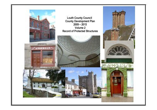
<strong>Louth</strong> <strong>County</strong> <strong>Council</strong><br />
<strong>County</strong> Development Plan<br />
2009 – 2015<br />
Volume 2<br />
<strong>Record</strong> <strong>of</strong> <strong>Protected</strong> <strong>Structures</strong>
<strong>Louth</strong> <strong>County</strong> <strong>Council</strong><br />
Development Plan 2009-2015<br />
<strong>Record</strong> <strong>of</strong> <strong>Protected</strong> <strong>Structures</strong><br />
Index Grid Map<br />
1 2<br />
3 4<br />
5<br />
6<br />
10 11<br />
12<br />
13<br />
11a 11a 11a 11a<br />
11a 11a 11a<br />
11b<br />
11b<br />
Planning Department<br />
<strong>Louth</strong> <strong>County</strong> <strong>Council</strong><br />
<strong>County</strong> Hall, Millennium Centre,<br />
Saint Alphonsus Road, Dundalk.<br />
Telephone: 042 9353180<br />
E-Mail: planning@louthcoco.ie<br />
7<br />
12a 12a<br />
12a 12a<br />
15a 15a<br />
15a 15a<br />
7A<br />
7A 7A 7A 7A 7A 7A<br />
4a<br />
4a<br />
2a 2a 2a 2a 2a 2a<br />
2a 2a 2a 2a 2a 2a 2a<br />
5b 5b 5b 5b 5b 5b 5b<br />
5b<br />
14 15<br />
16<br />
17a<br />
17a 17a<br />
18a 18a 18a<br />
18a<br />
17 18<br />
19<br />
20a 20a 20a 20a 20a 20a 20a 20a 20a 20a 20a 20a 20a 20a 20a 20a 20a 20a<br />
20a 20a 20a<br />
20 21<br />
22<br />
22b<br />
22b 22b<br />
23 24<br />
25<br />
8<br />
25a 25a<br />
25a<br />
25b<br />
25b<br />
22a 22a<br />
22a 22a<br />
Legend<br />
Note: Details shown on this map are for information purposes only.<br />
�<br />
Further details on any item should be clarified with <strong>Louth</strong> <strong>County</strong> <strong>Council</strong>.<br />
The map has been produced by <strong>Louth</strong> <strong>County</strong> <strong>Council</strong> with available Local Authority and<br />
Ordnance Survey data.<br />
(C) Ordnance Survey Ireland. All rights reserved. License Number 2003/07CCMA/<br />
<strong>Louth</strong> Local Authorities.<br />
Unauthorised reproduction <strong>of</strong> this map infringes state copyright.<br />
5a 5a 5a 5a 5a 5a 5a 5a 5a 5a 5a 5a 5a<br />
5a<br />
9a<br />
9a 9a 9a 9a 9a 9a 9a<br />
9b 9b 9b 9b 9b 9b 9b 9b 9b 9b 9b 9b 9b 9b 9b 9b 9b 9b<br />
9b<br />
9<br />
<strong>Protected</strong> Structure<br />
Dundalk & Environs Development<br />
Plan Boundary.<br />
All <strong>Protected</strong> <strong>Structures</strong><br />
within this boundary are in<br />
The Dundalk & Environs Development Plan
⊳<br />
1<br />
310648.2<br />
310648.2 323379.4<br />
317049.9<br />
Planning Department<br />
<strong>Louth</strong> <strong>County</strong> <strong>Council</strong><br />
<strong>County</strong> Hall, Millennium Centre,<br />
Saint Alphonsus Road, Dundalk.<br />
Telephone: 042 9353180<br />
E-Mail: planning@louthcoco.ie<br />
Note: Details shown on this map are for information purposes only.<br />
Further details on any item should be clarified with <strong>Louth</strong> <strong>County</strong> <strong>Council</strong>.<br />
The map has been produced by <strong>Louth</strong> <strong>County</strong> <strong>Council</strong> with available Local Authority and Ordnance Survey data.<br />
(C) Ordnance Survey Ireland. All rights reserved. License Number 2003/07CCMA/<strong>Louth</strong> Local Authorities.<br />
Unauthorised reproduction <strong>of</strong> this map infringes state copyright.<br />
Not to scale when printed A3 Landscape<br />
-<br />
5<br />
�<br />
�<br />
1<br />
<strong>Louth</strong> <strong>County</strong> <strong>Council</strong><br />
<strong>Record</strong> <strong>of</strong> <strong>Protected</strong> <strong>Structures</strong><br />
Sheet No<br />
1<br />
( <strong>Protected</strong> Structure<br />
323379.4 320290.8<br />
�317049.9<br />
-<br />
�<br />
320290.8
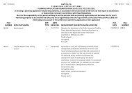
I. D. No. Map<br />
Sheet<br />
<strong>Louth</strong> <strong>County</strong> Development Plan 2009 - 2015.<br />
<strong>Record</strong> <strong>of</strong> <strong>Protected</strong> <strong>Structures</strong>.<br />
Address Name Description Notes NIAH No.<br />
see<br />
buildings<strong>of</strong>ireland.ie<br />
LHS001-001 1 Ravensdale Park Dwelling - Former<br />
School<br />
Detached former school, built c. 1830, now in private domestic use.<br />
Page 1 <strong>of</strong> 1 <strong>of</strong> Map 1.
⊳<br />
1<br />
310648.2<br />
310648.2 323379.4<br />
317049.9<br />
Planning Department<br />
<strong>Louth</strong> <strong>County</strong> <strong>Council</strong><br />
<strong>County</strong> Hall, Millennium Centre,<br />
Saint Alphonsus Road, Dundalk.<br />
Telephone: 042 9353180<br />
E-Mail: planning@louthcoco.ie<br />
9999999<br />
8<br />
7<br />
111111111111111<br />
Note: Details shown on this map are for information purposes only.<br />
Further details on any item should be clarified with <strong>Louth</strong> <strong>County</strong> <strong>Council</strong>.<br />
The map has been produced by <strong>Louth</strong> <strong>County</strong> <strong>Council</strong> with available Local Authority and Ordnance Survey data.<br />
(C) Ordnance Survey Ireland. All rights reserved. License Number 2003/07CCMA/<strong>Louth</strong> Local Authorities.<br />
Unauthorised reproduction <strong>of</strong> this map infringes state copyright.<br />
Not to scale when printed A3 Landscape<br />
-<br />
5<br />
�<br />
�<br />
<strong>Louth</strong> <strong>County</strong> <strong>Council</strong><br />
<strong>Record</strong> <strong>of</strong> <strong>Protected</strong> <strong>Structures</strong><br />
Sheet No<br />
2<br />
( <strong>Protected</strong> Structure<br />
323379.4 320290.8<br />
�317049.9<br />
-<br />
�<br />
320290.8
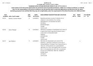
I. D. No. Map<br />
Sheet<br />
<strong>Louth</strong> <strong>County</strong> Development Plan 2009 - 2015.<br />
<strong>Record</strong> <strong>of</strong> <strong>Protected</strong> <strong>Structures</strong>.<br />
Address Name Description Notes NIAH No.<br />
see<br />
buildings<strong>of</strong>ireland.ie<br />
Lhs002-001 2 Drummullagh St Andrew's Church Church Freestanding former Church <strong>of</strong> Ireland church, dated 1838, Three-bay nave, three-stage pinnacled<br />
square tower centrally located at west end, single-bay chancel to east end with lean-to vestry projecting<br />
from south side.<br />
LHS002-007 2 Beacon, Cornamucklagh Beacon Lighthouse Freestanding light beacon, built c. 1880, one <strong>of</strong> a pair. Circular-plan, tapering shaft, conical ro<strong>of</strong>. Ashlar<br />
granite ro<strong>of</strong>, projecting eaves corbel string. Uncoursed rubble granite walling.<br />
LHS002-008 2 Lighthouse, Cornamucklagh Lighthouse Lighthouse Freestanding light beacon, built c. 1880, one <strong>of</strong> a pair. Circular-plan, tapering shaft, conical ro<strong>of</strong>. Ashlar<br />
granite ro<strong>of</strong>, projecting eaves corbel string. Uncoursed rubble granite walling.<br />
LHS002-009 2 Cornamucklagh House Detached three-bay two-storey house, built c. 1920. Slightly projecting flat-ro<strong>of</strong>ed single-storey entrance<br />
porch flanked by full-height canted bay windows, single-storey pitched ro<strong>of</strong> wing to east.<br />
Page 1 <strong>of</strong> 1 <strong>of</strong> Map 2.<br />
13833004<br />
13900201<br />
13900202<br />
13900203
⊳<br />
-<br />
291260.2<br />
291260.2 316702.1<br />
310381.5<br />
Planning Department<br />
<strong>Louth</strong> <strong>County</strong> <strong>Council</strong><br />
<strong>County</strong> Hall, Millennium Centre,<br />
Saint Alphonsus Road, Dundalk.<br />
Telephone: 042 9353180<br />
E-Mail: planning@louthcoco.ie<br />
- �<br />
�<br />
Note: Details shown on this map are for information purposes only.<br />
Further details on any item should be clarified with <strong>Louth</strong> <strong>County</strong> <strong>Council</strong>.<br />
The map has been produced by <strong>Louth</strong> <strong>County</strong> <strong>Council</strong> with available Local Authority and Ordnance Survey data.<br />
(C) Ordnance Survey Ireland. All rights reserved. License Number 2003/07CCMA/<strong>Louth</strong> Local Authorities.<br />
Unauthorised reproduction <strong>of</strong> this map infringes state copyright.<br />
Not to scale when printed A3 Landscape<br />
6<br />
5<br />
<strong>Louth</strong> <strong>County</strong> <strong>Council</strong><br />
<strong>Record</strong> <strong>of</strong> <strong>Protected</strong> <strong>Structures</strong><br />
Sheet No<br />
3<br />
666666666666666<br />
1111111111111<br />
2<br />
( <strong>Protected</strong> Structure<br />
3333333333333<br />
316702.1 300902.4<br />
�310381.5<br />
4<br />
�<br />
300902.4
I. D. No. Map<br />
Sheet<br />
<strong>Louth</strong> <strong>County</strong> Development Plan 2009 - 2015.<br />
<strong>Record</strong> <strong>of</strong> <strong>Protected</strong> <strong>Structures</strong>.<br />
Address Name Description Notes NIAH No.<br />
see<br />
buildings<strong>of</strong>ireland.ie<br />
Lhs003-001 3 Roche Roche Castle Ruin Pale frontier castle from 1230, triangular plan, walled enclosure with bastions, great hall, and gatehouse.<br />
LHS003-002 3 Drumbilla Kiln Detached lime kiln, built c. 1860, now a ruin. Rectangular-plan, extended to north with additional kiln c.<br />
1870, ramp to east.<br />
LHS003-003 3 Dungooly Dungooly Bridge Road Bridge Double-span road-over-river stone bridge built c. 1830. 13900302<br />
LHS003-005 3 Shortstone West House Detached three-bay two-storey house, built c. 1800. Rectangular-plan with return to west, single-storey<br />
flat-ro<strong>of</strong>ed addition to south-west angle c. 1950.<br />
LHS003-006 3 Slieve House Detached three-bay single-storey house, built c. 1800. Rectangular-plan, single-storey link to two-bay<br />
two-storey house c. 1950 to west with attached outbuildings and east and west farmyard.<br />
Page 1 <strong>of</strong> 1 <strong>of</strong> Map 3.<br />
13900301<br />
13900305<br />
13900306
⊳<br />
3<br />
301050.0<br />
301050.0 316896.1<br />
310575.4<br />
12<br />
12<br />
13<br />
13<br />
14 14 14 14 14 14 14<br />
14 14 14 14 14 14 14 14<br />
15<br />
15<br />
Planning Department<br />
<strong>Louth</strong> <strong>County</strong> <strong>Council</strong><br />
<strong>County</strong> Hall, Millennium Centre,<br />
Saint Alphonsus Road, Dundalk.<br />
Telephone: 042 9353180<br />
E-Mail: planning@louthcoco.ie<br />
16<br />
16<br />
1 �<br />
7<br />
�<br />
Note: Details shown on this map are for information purposes only.<br />
Further details on any item should be clarified with <strong>Louth</strong> <strong>County</strong> <strong>Council</strong>.<br />
The map has been produced by <strong>Louth</strong> <strong>County</strong> <strong>Council</strong> with available Local Authority and Ordnance Survey data.<br />
(C) Ordnance Survey Ireland. All rights reserved. License Number 2003/07CCMA/<strong>Louth</strong> Local Authorities.<br />
Unauthorised reproduction <strong>of</strong> this map infringes state copyright.<br />
Not to scale when printed A3 Landscape<br />
17<br />
17<br />
22<br />
22<br />
19<br />
19<br />
20<br />
20<br />
23<br />
23<br />
21<br />
21<br />
3<br />
4<br />
26<br />
26<br />
25<br />
25<br />
27<br />
27<br />
28<br />
28<br />
29<br />
29<br />
5<br />
40<br />
40<br />
<strong>Louth</strong> <strong>County</strong> <strong>Council</strong><br />
<strong>Record</strong> <strong>of</strong> <strong>Protected</strong> <strong>Structures</strong><br />
Sheet No<br />
4<br />
See See See See See See See See See See See See See See Sheet Sheet Sheet Sheet Sheet Sheet Sheet Sheet Sheet Sheet Sheet Sheet Sheet Sheet No. No. No. No. No. No. No. No. No. No. No. No. No. No. 4a-Ravensdale<br />
4a-Ravensdale<br />
4a-Ravensdale<br />
4a-Ravensdale<br />
4a-Ravensdale<br />
4a-Ravensdale<br />
4a-Ravensdale<br />
4a-Ravensdale<br />
4a-Ravensdale<br />
4a-Ravensdale<br />
4a-Ravensdale<br />
6d<br />
6d 6d 6d 6d 6d 6d 6d 6d 6d 6d 6d 6d 6d<br />
6666666666666666666<br />
6c<br />
6c<br />
31 31 31 31 31 31 31 31 31 31 31 31 31<br />
31 31 31 31 31 31 31 31 31 31 31<br />
36<br />
36 36 36 36 36 36 36 36 36 36 36<br />
7777777777777<br />
34<br />
34 34 34 34 34 34 34 34 34 34 34 34 34 34 34 34 34 34 34 34 34 34 34<br />
(<br />
37 37 37 37 37 37 37 37 37 37 37 37 37 37 37 37 37 37 37<br />
37<br />
38 38 38 38 38 38 38 38 38 38 38 38 38<br />
38<br />
39 39 39 39 39 39 39<br />
39 39 39 39 39 39 39 39 39 39 39 39 39 39 39 39 39<br />
8888888888888888888<br />
9<br />
10 10 10 10<br />
10 10 10 10<br />
11 11 11 11 11 11 11<br />
11 11 11 11 11 11 11 11<br />
<strong>Protected</strong> Structure<br />
316896.1 310692.3<br />
�310575.4<br />
All <strong>Protected</strong> <strong>Structures</strong> within<br />
this boundary are in the<br />
Dundalk & Environs Plan<br />
5<br />
�<br />
310692.3
CF<br />
FF<br />
N1<br />
CR<br />
CR<br />
N1<br />
CR<br />
UND<br />
Proleek<br />
CF<br />
Lime Works<br />
25<br />
25<br />
PROLEEK ACRES<br />
Reservoir<br />
CF<br />
Megalithic<br />
Tomb<br />
CF<br />
FF<br />
CR<br />
UND<br />
TKF<br />
Fulacht Fia<br />
Planning Department<br />
<strong>Louth</strong> <strong>County</strong> <strong>Council</strong><br />
<strong>County</strong> Hall, Millennium Centre,<br />
Saint Alphonsus Road, Dundalk.<br />
Telephone: 042 9353180<br />
E-Mail: planning@louthcoco.ie<br />
UND<br />
CF<br />
CF<br />
CF<br />
CF<br />
CR<br />
FF<br />
Ringfort<br />
Souterrain<br />
UND<br />
Ringfort<br />
Ringfort<br />
FF<br />
CR<br />
CR<br />
CS<br />
CR<br />
FF<br />
CF<br />
BROUGHATTIN<br />
6d 6d 6d 6d 6d 6d 6d 6d 6d 6d 6d 6d 6d<br />
6d 6d 6d 6d 6d 6d 6d 6d 6d 6d 6d<br />
Enclosure<br />
(Site <strong>of</strong>)<br />
Thompson's<br />
Bridge<br />
CS<br />
R174<br />
Church<br />
Aqueduct<br />
6c<br />
6c<br />
Ravensdale<br />
Bridge<br />
Note: Details shown on this map are for information purposes only.<br />
Further details on any item should be clarified with <strong>Louth</strong> <strong>County</strong> <strong>Council</strong>.<br />
The map has been produced by <strong>Louth</strong> <strong>County</strong> <strong>Council</strong> with available Local Authority and Ordnance Survey data.<br />
(C) Ordnance Survey Ireland. All rights reserved. License Number 2003/07CCMA/<strong>Louth</strong> Local Authorities.<br />
Unauthorised reproduction <strong>of</strong> this map infringes state copyright.<br />
Not to scale when printed A3 Landscape<br />
UND<br />
Post<br />
Office<br />
6<br />
31<br />
31<br />
CR<br />
6b<br />
6b<br />
36<br />
36<br />
CR<br />
32<br />
32<br />
R174<br />
34<br />
34<br />
35 35 35 35 35<br />
35 35 35 35 35 35 35 35<br />
Ravensdale<br />
37 37 37 37<br />
37 37 37 37 37<br />
Anaverna Bridge<br />
Ringfort<br />
38<br />
38<br />
UND<br />
DOOLARGY<br />
<strong>Louth</strong> <strong>County</strong> <strong>Council</strong><br />
<strong>Record</strong> <strong>of</strong> <strong>Protected</strong> <strong>Structures</strong><br />
Sheet No 4(a) - Ravensdale<br />
Ringfort's<br />
Carrabane<br />
( <strong>Protected</strong> Structure<br />
�
I. D. No. Map<br />
Sheet<br />
<strong>Louth</strong> <strong>County</strong> Development Plan 2009 - 2015.<br />
<strong>Record</strong> <strong>of</strong> <strong>Protected</strong> <strong>Structures</strong>.<br />
Address Name Description Notes NIAH No.<br />
see<br />
buildings<strong>of</strong>ireland.ie<br />
Lhs004-002 4 Balregan The Water Lodge House Detached three-bay two-storey over basement red brick house, built c. 1840. Square-plan. Originally<br />
the miller’s house. Includes stable yards and remains <strong>of</strong> mill.<br />
Lhs004-003 4 Aghaboys Mount Oliver Convent/nunnery Detached thirteen-bay single- and two-storey former country house by Sir John McNeill, built c. 1800,<br />
now in use as convent. Irregular plan, enlarged and remodelled c. 1850, two-storey central bay,<br />
pedimented entrance, flanked by single-storey balustraded bays, giant Corinthian portico & multiple<br />
ranges <strong>of</strong> extensions.<br />
Lhs004-004 4 Aghnaskeagh Aghnaskeagh Cairns Cairn/portal tomb<br />
Lhs004-005 4 Proleek Dolmen And Portal Tomb Dolmen<br />
Lhs004-006 4 Anaverna Anaverna House & Stables House c. 1790, by Thaddeus Gallagher, five-bay two-storey Georgian House, incl. Cast iron gates with Greek<br />
key pattern.Three ranges <strong>of</strong> multiple-bay two-storey stone former stable complex, now in private<br />
domestic and commercial use. U-plan surrounding cobbled yard.<br />
LHS004-006B 4 Anaverna Anaverna Stables In The<br />
Curtilage Of Anavaerna Ho.<br />
Stables Three ranges <strong>of</strong> multiple-bay two-storey stone former stable complex, built c. 1790, now in private<br />
domestic and commercial use. U-plan surrounding cobbled yard, single-storey lean-to c. 1850 and glass<br />
conservatory to west, stone steps to first floor south within yard, bellcote to south.<br />
LHS004-006C 4 Anaverna Doolargy Anaverna Gate Lodge Gate Lodge Detached three-bay single-storey former gate lodge, built c. 1840, now in private domestic use.<br />
Rectangular-plan, lean-to return and extension to west.<br />
LHS004-006D 4 Anaverna Ravensdale Anavernagate Lodge Gate Lodge Detached two-bay single-storey former gate lodge, built c. 1850, now in private domestic use. Central<br />
gable-fronted porch to east elevation.<br />
Lhs004-007 4 Anavernagh Sweat House & Stone<br />
Corbelled <strong>Structures</strong><br />
Sweathouse<br />
Lhs004-008 4 Doolargy St Mary's Catholic Church Church Freestanding Roman Catholic church, built c. 1840. T-plan, sacristy to east, cast-iron bellcote to northeast.<br />
Barn Church with pointed windows and pinnacles, incl boundary walls.<br />
Lhs004-009 4 Doolargy Sweat House & Stone<br />
Corbelled <strong>Structures</strong><br />
Lhs004-010 4 Doolargy Sweat House & Stone<br />
Corbelled <strong>Structures</strong><br />
Lhs004-011 4 Doolargy Sweat House & Stone<br />
Corbelled <strong>Structures</strong><br />
Sweathouse<br />
Sweathouse<br />
Sweathouse<br />
LHS004-012 4 Falmore Falmore Hall Country House Detached five-bay two-storey over basement house, built c. 1810. U-plan, full-height bow to south-west<br />
elevation, two-storey late eighteenth century former house, now wing, to north-west.<br />
LHS004-013 4 Calwood House, Balregan Calwood House House Detached three-bay two-storey former parochial house, built c. 1880, now in private domestic use.<br />
Rectangular-plan, canted bay to west, pitched and hipped ro<strong>of</strong>ed returns to east and north-east, recent<br />
extension to north and conservatory to south-east.<br />
Page 1 <strong>of</strong> 3 <strong>of</strong> Map 4.<br />
13900405<br />
13900414<br />
13900423<br />
13900423<br />
13900425<br />
13900422<br />
13900435<br />
13900401<br />
13900402
I. D. No. Map<br />
Sheet<br />
<strong>Louth</strong> <strong>County</strong> Development Plan 2009 - 2015.<br />
<strong>Record</strong> <strong>of</strong> <strong>Protected</strong> <strong>Structures</strong>.<br />
Address Name Description Notes NIAH No.<br />
see<br />
buildings<strong>of</strong>ireland.ie<br />
LHS004-014 4 Balregan House, Balregan Balregan House House Detached three-bay single-storey over basement with attic former miller's house, built c. 1760, now in<br />
use as private house. T-plan, half-dormer to east elevation.<br />
LHS004-015 4 Millbrook House, Balregan Millbrook House House Detached three-bay two-storey house, built c. 1840. Rectangular-plan, lean-to return and extension to<br />
north c. 1960, porch to south<br />
LHS004-016 4 Saint Brigid's Roman Catholic<br />
Church, Kilcurry<br />
Saint Brigid's Roman<br />
Catholic Church<br />
Church Freestanding Roman Catholic church, dated 1896. Cruciform-plan, shallow transepts to east and west,<br />
apse to south, three-stage tower between east transept and nave, sacristy to south-east.<br />
LHS004-017 4 Woodlawn, Faughart Upper Woodlawn House Detached three-bay two-storey house, built c. 1870, now ruinous. 13900407<br />
LHS004-019 4 Plaster Railway Bridge Single-arched stone road-over-rail bridge, built c. 1880. 13900409<br />
LHS004-020 4 Plaster Railway Bridge Single-arch stone road-over-railway bridge, built c. 1880. 13900410<br />
LHS004-021 4 Thistle House, Plaster Thistle House House Detached seven-bay two-storey house, built c. 1760, formerly five-bay, extended by two-bays to west.<br />
Formerly T-plan, returns and extension to north and east elevations, gable-fronted porch to south<br />
elevation.<br />
LHS004-022 4 Mount St.Frances, Aghaboys Mount St. Frances House Detached three-bay two-storey house, built c. 1870. Square-plan, porch to west, single-storey extension<br />
to north.<br />
LHS004-023 4 Mount Pleasant Lime Works,<br />
Aghaboys<br />
Mount Pleasant Lime<br />
Works<br />
Kiln Detached former lime kiln, built c. 1830, no longer in use. Irregular plan. Random rubble uncoursed<br />
stone walling. Triple arches, red brick surrounds, to west elevation for lime production; square-headed<br />
window and door openings to north elevation with red brick surrounds.<br />
LHS004-024 4 Ballymascanlon Gate Lodge Detached three-bay single-storey with attic former gate lodge, built c. 1820, now in private domestic use.<br />
Rectangular-plan, two-bay two-storey flat-ro<strong>of</strong>ed extension to east.<br />
LHS004-025 4 Proleek Acres Proleek Lime Works Kiln Detached stone former lime kiln, dated 1848. Irregular plan. Squared-and-snecked stone walling,<br />
crenellated parapet, bellcote to west, red brick dressings. Segmental-headed door openings to east, red<br />
brick arch; round-headed kiln opening to west elevation, date plaque reading "1848", inscriptions<br />
illegible. Lime works situated in open field.<br />
LHS004-026 4 Aghnaskeagh House,<br />
Aghnaskeagh<br />
LHS004-027 4 Ravensdale House,<br />
Ravensdale Park<br />
LHS004-028 4 Marble Bridge, Ravensdale<br />
Park<br />
13900403<br />
13900404<br />
13900406<br />
13900411<br />
13900412<br />
13900413<br />
13900416<br />
13900417<br />
Aghnaskeagh House House Detached two-storey house, built c. 1840. 13900418<br />
Ravensdale House Stables Detached former stables, built c. 1830, now in private domestic use. 13900419<br />
Marble Bridge Road Bridge Single-arch road-over-river bridge, built c. 1790. 13900420<br />
Page 2 <strong>of</strong> 3 <strong>of</strong> Map 4.
I. D. No. Map<br />
Sheet<br />
<strong>Louth</strong> <strong>County</strong> Development Plan 2009 - 2015.<br />
<strong>Record</strong> <strong>of</strong> <strong>Protected</strong> <strong>Structures</strong>.<br />
Address Name Description Notes NIAH No.<br />
see<br />
buildings<strong>of</strong>ireland.ie<br />
LHS004-029 4 Curralhir Bridge, Ravensdale<br />
Park<br />
Curralhir Bridge Road Bridge Double-arch road-over-river bridge, built c. 1780. 13900421<br />
LHS004-031 4 Sruhan house, Doolargy Sruhan House House Detached three-bay two-storey over basement house, built c. 1870. Canted bay to east elevation, halfdormers<br />
to south elevation, projecting timber sheeted bay to attic storey c. 1970 and integral carriage<br />
arch to west elevation.<br />
LHS004-032 4 Doolargy Court House Court House Detached gable-fronted single-bay two-storey court house, built c. 1850, no longer in use. Rectangularplan.<br />
LHS004-034 4 Caraban House, Doolargy Caraban House House Detached three-bay two-storey with attic house, built c. 1845. Half-dormer to west, crenellated entrance<br />
porch to west, canted bay windows to north and south, extension to east, c. 2005.<br />
LHS004-035 4 Ravensdale National School,<br />
Doolargy<br />
Ravensdale National<br />
School<br />
School Detached three-bay two-storey with attic former school, built c. 1850, now in domestic use. Double-pile,<br />
porch to west, extension to east.<br />
LHS004-036 4 Ravensdale House, Doolargy Ravensdale House Country House Detached three-bay two-storey with attic house, built c. 1770. Return and lean-to addition to east. 13900431<br />
LHS004-037 4 Doolargy Cottage, Doolargy Doolargy Cottage House Detached six-bay two-storey over basement house, built c. 1780. L-plan, lean-to extension to east c.<br />
1950, porch to south c. 1950.<br />
LHS004-038 4 Doolargy House, Doolargy Doolargy House House Detached double-pile three-bay two-storey over basement house, built c. 1780. Rectangular-plan, twostorey<br />
canted bay to north elevation, single-storey extension to east c. 1900.<br />
LHS004-039 4 Ravensdale Parochial house,<br />
Doolargy<br />
Ravensdale Parochial<br />
House<br />
LHS004-040 4 Gate Lodge - Ravensdale Park Gate Lodge Ravensdale<br />
Park<br />
Parochial House Detached three-bay two-storey parochial house, built c. 1880. Rectangular-plan, single-bay breakfronts<br />
to south and west elevations, porch to west elevation, extension c. 1900 to east.<br />
Gate Lodge Three bay single storey Gate Lodge associated with Ravensdale Park House.<br />
Page 3 <strong>of</strong> 3 <strong>of</strong> Map 4.<br />
13900426<br />
13900427<br />
13900429<br />
13900430<br />
13900432<br />
13900433<br />
13900434
⊳<br />
4<br />
310813.0<br />
310813.0 317110.7<br />
310789.9<br />
Planning Department<br />
<strong>Louth</strong> <strong>County</strong> <strong>Council</strong><br />
<strong>County</strong> Hall, Millennium Centre,<br />
Saint Alphonsus Road, Dundalk.<br />
Telephone: 042 9353180<br />
E-Mail: planning@louthcoco.ie<br />
67<br />
67<br />
1<br />
66 66 66 66 66 66 66 66 66 66 66 66 66<br />
66 66 66 66 66 66 66<br />
69 69 69 69 69 69 69 69 69 69 69 69 69<br />
69<br />
2 �<br />
See See See See See See See Sheet Sheet Sheet No. No. 5b-Omeath<br />
5b-Omeath<br />
5b-Omeath<br />
5b-Omeath<br />
5b-Omeath<br />
5b-Omeath<br />
8<br />
��<br />
Note: Details shown on this map are for information purposes only.<br />
Further details on any item should be clarified with <strong>Louth</strong> <strong>County</strong> <strong>Council</strong>.<br />
The map has been produced by <strong>Louth</strong> <strong>County</strong> <strong>Council</strong> with available Local Authority and Ordnance Survey data.<br />
(C) Ordnance Survey Ireland. All rights reserved. License Number 2003/07CCMA/<strong>Louth</strong> Local Authorities.<br />
Unauthorised reproduction <strong>of</strong> this map infringes state copyright.<br />
Not to scale when printed A3 Landscape<br />
<strong>Louth</strong> <strong>County</strong> <strong>Council</strong><br />
<strong>Record</strong> <strong>of</strong> <strong>Protected</strong> <strong>Structures</strong><br />
Sheet No<br />
5<br />
30 30 30 30 30 30 30 30 30 30 30 30 30 30 30 30 30 30 30<br />
30 30 30 30 30 30 30 66666666666666 51 51 51 51 51 51 51<br />
51 51 51<br />
33<br />
33 33 33 33 33 33 33 33 33 33 33 33 33 33 33 33 33 33 33<br />
See See Sheet Sheet Sheet Sheet Sheet Sheet Sheet Sheet Sheet Sheet Sheet Sheet Sheet Sheet Sheet Sheet Sheet Sheet Sheet Sheet No. No. 5a-Carlingford<br />
5a-Carlingford<br />
23 23 23 23 23 23 23<br />
23 23 23 23 23 23 23 23 23 23 23<br />
46<br />
46<br />
50 50 50 50 50 50 50<br />
50 50 50 50 50 50 50 50 50<br />
7777777777777777777777777<br />
8888888888888 64 64 64 64 64 64 64 64 64 64 64 64 64<br />
64 64 64 64 64<br />
15 15 15 15 15 15 15 15 15 15 15 15 15 15 15 15 15 15 15<br />
15<br />
39 39 39 39 39 39 39 39 39 39 39 39 39<br />
39<br />
11 11 11 11 11 11 11<br />
11<br />
16<br />
11<br />
16<br />
11<br />
16 16 16 16 16 16 16 16 16 16 16 16 16 16 16 16 16<br />
16 16 16 16 16 16 16 16 16 16 16<br />
71<br />
71<br />
( <strong>Protected</strong> Structure<br />
ACA Boundary<br />
317110.7 320455.6<br />
�310789.9<br />
-<br />
�<br />
320455.6
4.4<br />
4.1<br />
Flat<br />
HWM<br />
4.1<br />
5.1<br />
4.6<br />
4.0<br />
4.0<br />
Fire Station<br />
2.7<br />
3.0<br />
Quay<br />
3.0<br />
Pier<br />
3.9<br />
4.1<br />
Rock<br />
Pigeon House<br />
(In Ruins)<br />
HWM<br />
2.7<br />
3.3<br />
3.5<br />
Area Under Construction<br />
Sailing<br />
Sand and Shingle<br />
Club<br />
Slipway<br />
2.2<br />
Area Under Construction<br />
10Kv<br />
Pond<br />
Pond<br />
3.9<br />
3.1<br />
3.2<br />
3.9<br />
2.1<br />
Sand and Shingle<br />
Slip<br />
3.6<br />
3.7<br />
Chalk<br />
House<br />
3.3<br />
3.7<br />
5.5<br />
RC<br />
Church<br />
4.1<br />
Tholsel St<br />
Woods<br />
Harbour<br />
LWM<br />
Quay<br />
3.5<br />
Pier<br />
Quay<br />
Mud<br />
Monument<br />
3.2<br />
4.2<br />
Park<br />
3.6<br />
Taaffes<br />
Castle<br />
Car<br />
3.6<br />
4.1<br />
<strong>New</strong>ry St<br />
5.9<br />
Presb<br />
Ch<br />
6.2<br />
11.0<br />
(In Ruins)<br />
Abbey<br />
8.8<br />
Grave Yard<br />
Court<br />
Abbey<br />
Trinity Mews<br />
8.2<br />
Trinity Close<br />
City Wall<br />
Construction<br />
Area Under<br />
Market St<br />
6.8<br />
6.2<br />
City Wall<br />
21.9<br />
Hall<br />
River Street<br />
10.7<br />
10Kv<br />
Shingle<br />
3.8<br />
and<br />
Sand<br />
5.3<br />
3.4<br />
(In Ruins)<br />
4.5<br />
14.2<br />
6.2<br />
Back Lane<br />
King John's Castle<br />
Sand and Shingle<br />
Stn<br />
GS<br />
15.6<br />
City Wall<br />
31<br />
31<br />
31<br />
31<br />
31<br />
31<br />
31<br />
31<br />
31<br />
31<br />
31<br />
31<br />
31<br />
31<br />
31<br />
31<br />
31<br />
31<br />
31<br />
31<br />
31<br />
31<br />
31<br />
31<br />
31<br />
31<br />
31<br />
31<br />
31<br />
31<br />
31<br />
31<br />
31<br />
31<br />
31<br />
31<br />
31<br />
31<br />
31<br />
31<br />
31<br />
31<br />
31<br />
31<br />
31<br />
31<br />
31<br />
31<br />
31<br />
30<br />
30<br />
30<br />
30<br />
30<br />
30<br />
30<br />
30<br />
30<br />
30<br />
30<br />
30<br />
30<br />
30<br />
30<br />
30<br />
30<br />
30<br />
30<br />
30<br />
30<br />
30<br />
30<br />
30<br />
30<br />
30<br />
30<br />
30<br />
30<br />
30<br />
30<br />
30<br />
30<br />
30<br />
30<br />
30<br />
30<br />
30<br />
30<br />
30<br />
30<br />
30<br />
30<br />
30<br />
30<br />
30<br />
30<br />
30<br />
30<br />
55<br />
55<br />
55<br />
55<br />
55<br />
55<br />
55<br />
55<br />
55<br />
55<br />
55<br />
55<br />
55<br />
55<br />
55<br />
55<br />
55<br />
55<br />
55<br />
55<br />
55<br />
55<br />
55<br />
55<br />
55<br />
55<br />
55<br />
55<br />
55<br />
55<br />
55<br />
55<br />
55<br />
55<br />
55<br />
55<br />
55<br />
55<br />
55<br />
55<br />
55<br />
55<br />
55<br />
55<br />
55<br />
55<br />
55<br />
55<br />
55<br />
54<br />
54<br />
54<br />
54<br />
54<br />
54<br />
54<br />
54<br />
54<br />
54<br />
54<br />
54<br />
54<br />
54<br />
54<br />
54<br />
54<br />
54<br />
54<br />
54<br />
54<br />
54<br />
54<br />
54<br />
54<br />
54<br />
54<br />
54<br />
54<br />
54<br />
54<br />
54<br />
54<br />
54<br />
54<br />
54<br />
54<br />
54<br />
54<br />
54<br />
54<br />
54<br />
54<br />
54<br />
54<br />
54<br />
54<br />
54<br />
54<br />
58<br />
58<br />
58<br />
58<br />
58<br />
58<br />
58<br />
58<br />
58<br />
58<br />
58<br />
58<br />
58<br />
58<br />
58<br />
58<br />
58<br />
58<br />
58<br />
58<br />
58<br />
58<br />
58<br />
58<br />
58<br />
58<br />
58<br />
58<br />
58<br />
58<br />
58<br />
58<br />
58<br />
58<br />
58<br />
58<br />
58<br />
58<br />
58<br />
58<br />
58<br />
58<br />
58<br />
58<br />
58<br />
58<br />
58<br />
58<br />
58<br />
57<br />
57<br />
57<br />
57<br />
57<br />
57<br />
57<br />
57<br />
57<br />
57<br />
57<br />
57<br />
57<br />
57<br />
57<br />
57<br />
57<br />
57<br />
57<br />
57<br />
57<br />
57<br />
57<br />
57<br />
57<br />
57<br />
57<br />
57<br />
57<br />
57<br />
57<br />
57<br />
57<br />
57<br />
57<br />
57<br />
57<br />
57<br />
57<br />
57<br />
57<br />
57<br />
57<br />
57<br />
57<br />
57<br />
57<br />
57<br />
57<br />
56<br />
56<br />
56<br />
56<br />
56<br />
56<br />
56<br />
56<br />
56<br />
56<br />
56<br />
56<br />
56<br />
56<br />
56<br />
56<br />
56<br />
56<br />
56<br />
56<br />
56<br />
56<br />
56<br />
56<br />
56<br />
56<br />
56<br />
56<br />
56<br />
56<br />
56<br />
56<br />
56<br />
56<br />
56<br />
56<br />
56<br />
56<br />
56<br />
56<br />
56<br />
56<br />
56<br />
56<br />
56<br />
56<br />
56<br />
56<br />
56<br />
59<br />
59<br />
59<br />
59<br />
59<br />
59<br />
59<br />
59<br />
59<br />
59<br />
59<br />
59<br />
59<br />
59<br />
59<br />
59<br />
59<br />
59<br />
59<br />
59<br />
59<br />
59<br />
59<br />
59<br />
59<br />
59<br />
59<br />
59<br />
59<br />
59<br />
59<br />
59<br />
59<br />
59<br />
59<br />
59<br />
59<br />
59<br />
59<br />
59<br />
59<br />
59<br />
59<br />
59<br />
59<br />
59<br />
59<br />
59<br />
59<br />
18<br />
18<br />
18<br />
18<br />
18<br />
18<br />
18<br />
18<br />
18<br />
18<br />
18<br />
18<br />
18<br />
18<br />
18<br />
18<br />
18<br />
18<br />
18<br />
18<br />
18<br />
18<br />
18<br />
18<br />
18<br />
18<br />
18<br />
18<br />
18<br />
18<br />
18<br />
18<br />
18<br />
18<br />
18<br />
18<br />
18<br />
18<br />
18<br />
18<br />
18<br />
18<br />
18<br />
18<br />
18<br />
18<br />
18<br />
18<br />
18<br />
19<br />
19<br />
19<br />
19<br />
19<br />
19<br />
19<br />
19<br />
19<br />
19<br />
19<br />
19<br />
19<br />
19<br />
19<br />
19<br />
19<br />
19<br />
19<br />
19<br />
19<br />
19<br />
19<br />
19<br />
19<br />
19<br />
19<br />
19<br />
19<br />
19<br />
19<br />
19<br />
19<br />
19<br />
19<br />
19<br />
19<br />
19<br />
19<br />
19<br />
19<br />
19<br />
19<br />
19<br />
19<br />
19<br />
19<br />
19<br />
19<br />
23<br />
23<br />
23<br />
23<br />
23<br />
23<br />
23<br />
23<br />
23<br />
23<br />
23<br />
23<br />
23<br />
23<br />
23<br />
23<br />
23<br />
23<br />
23<br />
23<br />
23<br />
23<br />
23<br />
23<br />
23<br />
23<br />
23<br />
23<br />
23<br />
23<br />
23<br />
23<br />
23<br />
23<br />
23<br />
23<br />
23<br />
23<br />
23<br />
23<br />
23<br />
23<br />
23<br />
23<br />
23<br />
23<br />
23<br />
23<br />
23<br />
24<br />
24<br />
24<br />
24<br />
24<br />
24<br />
24<br />
24<br />
24<br />
24<br />
24<br />
24<br />
24<br />
24<br />
24<br />
24<br />
24<br />
24<br />
24<br />
24<br />
24<br />
24<br />
24<br />
24<br />
24<br />
24<br />
24<br />
24<br />
24<br />
24<br />
24<br />
24<br />
24<br />
24<br />
24<br />
24<br />
24<br />
24<br />
24<br />
24<br />
24<br />
24<br />
24<br />
24<br />
24<br />
24<br />
24<br />
24<br />
24<br />
27<br />
27<br />
27<br />
27<br />
27<br />
27<br />
27<br />
27<br />
27<br />
27<br />
27<br />
27<br />
27<br />
27<br />
27<br />
27<br />
27<br />
27<br />
27<br />
27<br />
27<br />
27<br />
27<br />
27<br />
27<br />
27<br />
27<br />
27<br />
27<br />
27<br />
27<br />
27<br />
27<br />
27<br />
27<br />
27<br />
27<br />
27<br />
27<br />
27<br />
27<br />
27<br />
27<br />
27<br />
27<br />
27<br />
27<br />
27<br />
27<br />
62<br />
62<br />
62<br />
62<br />
62<br />
62<br />
62<br />
62<br />
62<br />
62<br />
62<br />
62<br />
62<br />
62<br />
62<br />
62<br />
62<br />
62<br />
62<br />
62<br />
62<br />
62<br />
62<br />
62<br />
62<br />
62<br />
62<br />
62<br />
62<br />
62<br />
62<br />
62<br />
62<br />
62<br />
62<br />
62<br />
62<br />
62<br />
62<br />
62<br />
62<br />
62<br />
62<br />
62<br />
62<br />
62<br />
62<br />
62<br />
62<br />
61<br />
61<br />
61<br />
61<br />
61<br />
61<br />
61<br />
61<br />
61<br />
61<br />
61<br />
61<br />
61<br />
61<br />
61<br />
61<br />
61<br />
61<br />
61<br />
61<br />
61<br />
61<br />
61<br />
61<br />
61<br />
61<br />
61<br />
61<br />
61<br />
61<br />
61<br />
61<br />
61<br />
61<br />
61<br />
61<br />
61<br />
61<br />
61<br />
61<br />
61<br />
61<br />
61<br />
61<br />
61<br />
61<br />
61<br />
61<br />
61<br />
52<br />
52<br />
52<br />
52<br />
52<br />
52<br />
52<br />
52<br />
52<br />
52<br />
52<br />
52<br />
52<br />
52<br />
52<br />
52<br />
52<br />
52<br />
52<br />
52<br />
52<br />
52<br />
52<br />
52<br />
52<br />
52<br />
52<br />
52<br />
52<br />
52<br />
52<br />
52<br />
52<br />
52<br />
52<br />
52<br />
52<br />
52<br />
52<br />
52<br />
52<br />
52<br />
52<br />
52<br />
52<br />
52<br />
52<br />
52<br />
52<br />
99999<br />
32<br />
32<br />
32<br />
32<br />
32<br />
32<br />
32<br />
32<br />
32<br />
32<br />
32<br />
32<br />
32<br />
32<br />
32<br />
32<br />
32<br />
32<br />
32<br />
32<br />
32<br />
32<br />
32<br />
32<br />
32<br />
32<br />
32<br />
32<br />
32<br />
32<br />
32<br />
32<br />
32<br />
32<br />
32<br />
32<br />
32<br />
32<br />
32<br />
32<br />
32<br />
32<br />
32<br />
32<br />
32<br />
32<br />
32<br />
32<br />
32<br />
10<br />
10<br />
10<br />
10<br />
10<br />
10<br />
10<br />
10<br />
10<br />
10<br />
10<br />
10<br />
10<br />
10<br />
10<br />
10<br />
10<br />
10<br />
10<br />
10<br />
10<br />
10<br />
10<br />
10<br />
10<br />
10<br />
10<br />
10<br />
10<br />
10<br />
10<br />
10<br />
10<br />
10<br />
10<br />
10<br />
10<br />
10<br />
10<br />
10<br />
10<br />
10<br />
10<br />
10<br />
10<br />
10<br />
10<br />
10<br />
10<br />
35<br />
35<br />
35<br />
35<br />
35<br />
35<br />
35<br />
35<br />
35<br />
35<br />
35<br />
35<br />
35<br />
35<br />
35<br />
35<br />
35<br />
35<br />
35<br />
35<br />
35<br />
35<br />
35<br />
35<br />
35<br />
35<br />
35<br />
35<br />
35<br />
35<br />
35<br />
35<br />
35<br />
35<br />
35<br />
35<br />
35<br />
35<br />
35<br />
35<br />
35<br />
35<br />
35<br />
35<br />
35<br />
35<br />
35<br />
35<br />
35<br />
41<br />
41<br />
41<br />
41<br />
41<br />
41<br />
41<br />
41<br />
41<br />
41<br />
41<br />
41<br />
41<br />
41<br />
41<br />
41<br />
41<br />
41<br />
41<br />
41<br />
41<br />
41<br />
41<br />
41<br />
41<br />
41<br />
41<br />
41<br />
41<br />
41<br />
41<br />
41<br />
41<br />
41<br />
41<br />
41<br />
41<br />
41<br />
41<br />
41<br />
41<br />
41<br />
41<br />
41<br />
41<br />
41<br />
41<br />
41<br />
41<br />
40<br />
40<br />
40<br />
40<br />
40<br />
40<br />
40<br />
40<br />
40<br />
40<br />
40<br />
40<br />
40<br />
40<br />
40<br />
40<br />
40<br />
40<br />
40<br />
40<br />
40<br />
40<br />
40<br />
40<br />
40<br />
40<br />
40<br />
40<br />
40<br />
40<br />
40<br />
40<br />
40<br />
40<br />
40<br />
40<br />
40<br />
40<br />
40<br />
40<br />
40<br />
40<br />
40<br />
40<br />
40<br />
40<br />
40<br />
40<br />
40<br />
42<br />
42<br />
42<br />
42<br />
42<br />
42<br />
42<br />
42<br />
42<br />
42<br />
42<br />
42<br />
42<br />
42<br />
42<br />
42<br />
42<br />
42<br />
42<br />
42<br />
42<br />
42<br />
42<br />
42<br />
42<br />
42<br />
42<br />
42<br />
42<br />
42<br />
42<br />
42<br />
42<br />
42<br />
42<br />
42<br />
42<br />
42<br />
42<br />
42<br />
42<br />
42<br />
42<br />
42<br />
42<br />
42<br />
42<br />
42<br />
42<br />
39<br />
39<br />
39<br />
39<br />
39<br />
39<br />
39<br />
39<br />
39<br />
39<br />
39<br />
39<br />
39<br />
39<br />
39<br />
39<br />
39<br />
39<br />
39<br />
39<br />
39<br />
39<br />
39<br />
39<br />
39<br />
39<br />
39<br />
39<br />
39<br />
39<br />
39<br />
39<br />
39<br />
39<br />
39<br />
39<br />
39<br />
39<br />
39<br />
39<br />
39<br />
39<br />
39<br />
39<br />
39<br />
39<br />
39<br />
39<br />
39<br />
43<br />
43<br />
43<br />
43<br />
43<br />
43<br />
43<br />
43<br />
43<br />
43<br />
43<br />
43<br />
43<br />
43<br />
43<br />
43<br />
43<br />
43<br />
43<br />
43<br />
43<br />
43<br />
43<br />
43<br />
43<br />
43<br />
43<br />
43<br />
43<br />
43<br />
43<br />
43<br />
43<br />
43<br />
43<br />
43<br />
43<br />
43<br />
43<br />
43<br />
43<br />
43<br />
43<br />
43<br />
43<br />
43<br />
43<br />
43<br />
43<br />
6<br />
777777777777777777<br />
88888888<br />
11<br />
11<br />
11<br />
11<br />
11<br />
11<br />
11<br />
11<br />
11<br />
11<br />
11<br />
11<br />
11<br />
11<br />
11<br />
11<br />
11<br />
11<br />
11<br />
11<br />
11<br />
11<br />
11<br />
11<br />
11<br />
11<br />
11<br />
11<br />
11<br />
11<br />
11<br />
11<br />
11<br />
11<br />
11<br />
11<br />
11<br />
11<br />
11<br />
11<br />
11<br />
11<br />
11<br />
11<br />
11<br />
11<br />
11<br />
11<br />
11<br />
12<br />
12<br />
12<br />
12<br />
12<br />
12<br />
12<br />
12<br />
12<br />
12<br />
12<br />
12<br />
12<br />
12<br />
12<br />
12<br />
12<br />
12<br />
12<br />
12<br />
12<br />
12<br />
12<br />
12<br />
12<br />
12<br />
12<br />
12<br />
12<br />
12<br />
12<br />
12<br />
12<br />
12<br />
12<br />
12<br />
12<br />
12<br />
12<br />
12<br />
12<br />
12<br />
12<br />
12<br />
12<br />
12<br />
12<br />
12<br />
12<br />
14<br />
14<br />
14<br />
14<br />
14<br />
14<br />
14<br />
14<br />
14<br />
14<br />
14<br />
14<br />
14<br />
14<br />
14<br />
14<br />
14<br />
14<br />
14<br />
14<br />
14<br />
14<br />
14<br />
14<br />
14<br />
14<br />
14<br />
14<br />
14<br />
14<br />
14<br />
14<br />
14<br />
14<br />
14<br />
14<br />
14<br />
14<br />
14<br />
14<br />
14<br />
14<br />
14<br />
14<br />
14<br />
14<br />
14<br />
14<br />
14<br />
15<br />
15<br />
15<br />
15<br />
15<br />
15<br />
15<br />
15<br />
15<br />
15<br />
15<br />
15<br />
15<br />
15<br />
15<br />
15<br />
15<br />
15<br />
15<br />
15<br />
15<br />
15<br />
15<br />
15<br />
15<br />
15<br />
15<br />
15<br />
15<br />
15<br />
15<br />
15<br />
15<br />
15<br />
15<br />
15<br />
15<br />
15<br />
15<br />
15<br />
15<br />
15<br />
15<br />
15<br />
15<br />
15<br />
15<br />
15<br />
15<br />
16<br />
16<br />
16<br />
16<br />
16<br />
16<br />
16<br />
16<br />
16<br />
16<br />
16<br />
16<br />
16<br />
16<br />
16<br />
16<br />
16<br />
16<br />
16<br />
16<br />
16<br />
16<br />
16<br />
16<br />
16<br />
16<br />
16<br />
16<br />
16<br />
16<br />
16<br />
16<br />
16<br />
16<br />
16<br />
16<br />
16<br />
16<br />
16<br />
16<br />
16<br />
16<br />
16<br />
16<br />
16<br />
16<br />
16<br />
16<br />
16<br />
17<br />
17<br />
17<br />
17<br />
17<br />
17<br />
17<br />
17<br />
17<br />
17<br />
17<br />
17<br />
17<br />
17<br />
17<br />
17<br />
17<br />
17<br />
17<br />
17<br />
17<br />
17<br />
17<br />
17<br />
17<br />
17<br />
17<br />
17<br />
17<br />
17<br />
17<br />
17<br />
17<br />
17<br />
17<br />
17<br />
17<br />
17<br />
17<br />
17<br />
17<br />
17<br />
17<br />
17<br />
17<br />
17<br />
17<br />
17<br />
17<br />
20<br />
20<br />
20<br />
20<br />
20<br />
20<br />
20<br />
20<br />
20<br />
20<br />
20<br />
20<br />
20<br />
20<br />
20<br />
20<br />
20<br />
20<br />
20<br />
20<br />
20<br />
20<br />
20<br />
20<br />
20<br />
20<br />
20<br />
20<br />
20<br />
20<br />
20<br />
20<br />
20<br />
20<br />
20<br />
20<br />
20<br />
20<br />
20<br />
20<br />
20<br />
20<br />
20<br />
20<br />
20<br />
20<br />
20<br />
20<br />
20<br />
21<br />
21<br />
21<br />
21<br />
21<br />
21<br />
21<br />
21<br />
21<br />
21<br />
21<br />
21<br />
21<br />
21<br />
21<br />
21<br />
21<br />
21<br />
21<br />
21<br />
21<br />
21<br />
21<br />
21<br />
21<br />
21<br />
21<br />
21<br />
21<br />
21<br />
21<br />
21<br />
21<br />
21<br />
21<br />
21<br />
21<br />
21<br />
21<br />
21<br />
21<br />
21<br />
21<br />
21<br />
21<br />
21<br />
21<br />
21<br />
21<br />
26<br />
26<br />
26<br />
26<br />
26<br />
26<br />
26<br />
26<br />
26<br />
26<br />
26<br />
26<br />
26<br />
26<br />
26<br />
26<br />
26<br />
26<br />
26<br />
26<br />
26<br />
26<br />
26<br />
26<br />
26<br />
26<br />
26<br />
26<br />
26<br />
26<br />
26<br />
26<br />
26<br />
26<br />
26<br />
26<br />
26<br />
26<br />
26<br />
26<br />
26<br />
26<br />
26<br />
26<br />
26<br />
26<br />
26<br />
26<br />
26<br />
33<br />
33<br />
33<br />
33<br />
33<br />
33<br />
33<br />
33<br />
33<br />
33<br />
33<br />
33<br />
33<br />
33<br />
33<br />
33<br />
33<br />
33<br />
33<br />
33<br />
33<br />
33<br />
33<br />
33<br />
33<br />
33<br />
33<br />
33<br />
33<br />
33<br />
33<br />
33<br />
33<br />
33<br />
33<br />
33<br />
33<br />
33<br />
33<br />
33<br />
33<br />
33<br />
33<br />
33<br />
33<br />
33<br />
33<br />
33<br />
33<br />
34<br />
34<br />
34<br />
34<br />
34<br />
34<br />
34<br />
34<br />
34<br />
34<br />
34<br />
34<br />
34<br />
34<br />
34<br />
34<br />
34<br />
34<br />
34<br />
34<br />
34<br />
34<br />
34<br />
34<br />
34<br />
34<br />
34<br />
34<br />
34<br />
34<br />
34<br />
34<br />
34<br />
34<br />
34<br />
34<br />
34<br />
34<br />
34<br />
34<br />
34<br />
34<br />
34<br />
34<br />
34<br />
34<br />
34<br />
34<br />
34<br />
37<br />
37<br />
37<br />
37<br />
37<br />
37<br />
37<br />
37<br />
37<br />
37<br />
37<br />
37<br />
37<br />
37<br />
37<br />
37<br />
37<br />
37<br />
37<br />
37<br />
37<br />
37<br />
37<br />
37<br />
37<br />
37<br />
37<br />
37<br />
37<br />
37<br />
37<br />
37<br />
37<br />
37<br />
37<br />
37<br />
37<br />
37<br />
37<br />
37<br />
37<br />
37<br />
37<br />
37<br />
37<br />
37<br />
37<br />
37<br />
37<br />
49<br />
49<br />
49<br />
49<br />
49<br />
49<br />
49<br />
49<br />
49<br />
49<br />
49<br />
49<br />
49<br />
49<br />
49<br />
49<br />
49<br />
49<br />
49<br />
49<br />
49<br />
49<br />
49<br />
49<br />
49<br />
49<br />
49<br />
49<br />
49<br />
49<br />
49<br />
49<br />
49<br />
49<br />
49<br />
49<br />
49<br />
49<br />
49<br />
49<br />
49<br />
49<br />
49<br />
49<br />
49<br />
49<br />
49<br />
49<br />
49<br />
50<br />
50<br />
50<br />
50<br />
50<br />
50<br />
50<br />
50<br />
50<br />
50<br />
50<br />
50<br />
50<br />
50<br />
50<br />
50<br />
50<br />
50<br />
50<br />
50<br />
50<br />
50<br />
50<br />
50<br />
50<br />
50<br />
50<br />
50<br />
50<br />
50<br />
50<br />
50<br />
50<br />
50<br />
50<br />
50<br />
50<br />
50<br />
50<br />
50<br />
50<br />
50<br />
50<br />
50<br />
50<br />
50<br />
50<br />
50<br />
50<br />
51<br />
51<br />
51<br />
51<br />
51<br />
51<br />
51<br />
51<br />
51<br />
51<br />
51<br />
51<br />
51<br />
51<br />
51<br />
51<br />
51<br />
51<br />
51<br />
51<br />
51<br />
51<br />
51<br />
51<br />
51<br />
51<br />
51<br />
51<br />
51<br />
51<br />
51<br />
51<br />
51<br />
51<br />
51<br />
51<br />
51<br />
51<br />
51<br />
51<br />
51<br />
51<br />
51<br />
51<br />
51<br />
51<br />
51<br />
51<br />
51<br />
53<br />
53<br />
53<br />
53<br />
53<br />
53<br />
53<br />
53<br />
53<br />
53<br />
53<br />
53<br />
53<br />
53<br />
53<br />
53<br />
53<br />
53<br />
53<br />
53<br />
53<br />
53<br />
53<br />
53<br />
53<br />
53<br />
53<br />
53<br />
53<br />
53<br />
53<br />
53<br />
53<br />
53<br />
53<br />
53<br />
53<br />
53<br />
53<br />
53<br />
53<br />
53<br />
53<br />
53<br />
53<br />
53<br />
53<br />
53<br />
53<br />
63<br />
63<br />
63<br />
63<br />
63<br />
63<br />
63<br />
63<br />
63<br />
63<br />
63<br />
63<br />
63<br />
63<br />
63<br />
63<br />
63<br />
63<br />
63<br />
63<br />
63<br />
63<br />
63<br />
63<br />
63<br />
63<br />
63<br />
63<br />
63<br />
63<br />
63<br />
63<br />
63<br />
63<br />
63<br />
63<br />
63<br />
63<br />
63<br />
63<br />
63<br />
63<br />
63<br />
63<br />
63<br />
63<br />
63<br />
63<br />
63<br />
64<br />
64<br />
64<br />
64<br />
64<br />
64<br />
64<br />
64<br />
64<br />
64<br />
64<br />
64<br />
64<br />
64<br />
64<br />
64<br />
64<br />
64<br />
64<br />
64<br />
64<br />
64<br />
64<br />
64<br />
64<br />
64<br />
64<br />
64<br />
64<br />
64<br />
64<br />
64<br />
64<br />
64<br />
64<br />
64<br />
64<br />
64<br />
64<br />
64<br />
64<br />
64<br />
64<br />
64<br />
64<br />
64<br />
64<br />
64<br />
64<br />
71<br />
71<br />
71<br />
71<br />
71<br />
71<br />
71<br />
71<br />
71<br />
71<br />
71<br />
71<br />
71<br />
71<br />
71<br />
71<br />
71<br />
71<br />
71<br />
71<br />
71<br />
71<br />
71<br />
71<br />
71<br />
71<br />
71<br />
71<br />
71<br />
71<br />
71<br />
71<br />
71<br />
71<br />
71<br />
71<br />
71<br />
71<br />
71<br />
71<br />
71<br />
71<br />
71<br />
71<br />
71<br />
71<br />
71<br />
71<br />
71<br />
�<br />
Planning Department<br />
<strong>Louth</strong> <strong>County</strong> <strong>Council</strong><br />
<strong>County</strong> Hall, Millennium Centre,<br />
Saint Alphonsus Road, Dundalk.<br />
Telephone: 042 9353180<br />
E-Mail: planning@louthcoco.ie<br />
Note: Details shown on this map are for information purposes only.<br />
Further details on any item should be clarified with <strong>Louth</strong> <strong>County</strong> <strong>Council</strong>.<br />
The map has been produced by <strong>Louth</strong> <strong>County</strong> <strong>Council</strong> with available Local Authority and Ordnance Survey data.<br />
(C) Ordnance Survey Ireland. All rights reserved. License Number 2003/07CCMA/<strong>Louth</strong> Local Authorities.<br />
Unauthorised reproduction <strong>of</strong> this map infringes state copyright.<br />
<strong>Louth</strong> <strong>County</strong> <strong>Council</strong><br />
<strong>Record</strong> <strong>of</strong> <strong>Protected</strong> <strong>Structures</strong><br />
Sheet No<br />
( <strong>Protected</strong> Structure<br />
5(a) - Carlingford<br />
Not to scale when printed A3 Landscape<br />
ACA Boundary
50.8<br />
CF<br />
UND<br />
55.6<br />
CF<br />
53.4<br />
Planning Department<br />
<strong>Louth</strong> <strong>County</strong> <strong>Council</strong><br />
<strong>County</strong> Hall, Millennium Centre,<br />
Saint Alphonsus Road, Dundalk.<br />
Telephone: 042 9353180<br />
E-Mail: planning@louthcoco.ie<br />
50.2<br />
42.3<br />
Omeath<br />
KNOCKNAGORAN<br />
CF<br />
30.7<br />
Under Development<br />
10Kv<br />
UND<br />
8.6<br />
18.7<br />
Note: Details shown on this map are for information purposes only.<br />
Further details on any item should be clarified with <strong>Louth</strong> <strong>County</strong> <strong>Council</strong>.<br />
The map has been produced by <strong>Louth</strong> <strong>County</strong> <strong>Council</strong> with available Local Authority and Ordnance Survey data.<br />
(C) Ordnance Survey Ireland. All rights reserved. License Number 2003/07CCMA/<strong>Louth</strong> Local Authorities.<br />
Unauthorised reproduction <strong>of</strong> this map infringes state copyright.<br />
43.0<br />
9.0<br />
UND<br />
Ardán<br />
Gentili<br />
Not to scale when printed A3 Landscape<br />
37.6<br />
8.7<br />
13.4<br />
CF<br />
UND<br />
CR<br />
29.7<br />
9.4<br />
Bay View<br />
Tavern<br />
PO<br />
Lisieux<br />
10.1<br />
Area Under<br />
Development<br />
18.7<br />
Hotel<br />
10.5<br />
10.0<br />
Area Under<br />
Development<br />
Nucella<br />
Lodge<br />
4.7<br />
67<br />
67<br />
Prospect<br />
House<br />
10Kv<br />
3.0<br />
8.5<br />
1<br />
2<br />
3<br />
4<br />
7.4<br />
Coastguard Station<br />
<strong>Louth</strong> <strong>County</strong> <strong>Council</strong><br />
<strong>Record</strong> <strong>of</strong> <strong>Protected</strong> <strong>Structures</strong><br />
Sheet No 5(b) - Omeath<br />
Garda<br />
Station<br />
3.5<br />
66 66 66 66 66 66 66 66 66 66 66 66 66 66 66 66 66 66 66<br />
66 66 66 66 66 66 66 66 66 66 66<br />
6.3<br />
3.2<br />
Oberon Villa<br />
Patrickville<br />
4.8<br />
69 69 69 69 69 69 69 69<br />
2.0<br />
Caravan Park<br />
( <strong>Protected</strong> Structure<br />
69 �<br />
3.2
I. D. No. Map<br />
Sheet<br />
<strong>Louth</strong> <strong>County</strong> Development Plan 2009 - 2015.<br />
<strong>Record</strong> <strong>of</strong> <strong>Protected</strong> <strong>Structures</strong>.<br />
Address Name Description Notes NIAH No.<br />
see<br />
buildings<strong>of</strong>ireland.ie<br />
Lhs005-001 5 Shore Road , Knocknagoran Shore Road, 1 House Terrace <strong>of</strong> four two-bay two-storey former coastguard houses, built c. 1800, with senior coastguard's<br />
house at east end, now in private domestic use.<br />
Lhs005-002 5 Shore Road , Knocknagoran Shore Road, 2 House Terrace <strong>of</strong> four two-bay two-storey former coastguard houses, built c. 1800, with senior coastguard's<br />
house at east end, now in private domestic use.<br />
Lhs005-003 5 Shore Road , Knocknagoran Shore Road, 3 House Terrace <strong>of</strong> four two-bay two-storey former coastguard houses, built c. 1800, with senior coastguard's<br />
house at east end, now in private domestic use.<br />
Lhs005-004 5 Shore Road , Knocknagoran Shore Road, 4 House Terrace <strong>of</strong> four two-bay two-storey former coastguard houses, built c. 1800, with senior coastguard's<br />
house at east end, now in private domestic use.<br />
Lhs005-006 5 Liberties <strong>of</strong> Carlingford King John's Castle Castle c.1210, D-shaped plan, with open courtyard and tall square tower.<br />
Lhs005-007 5 Liberties <strong>of</strong> Carlingford Taaffe's Castle Towerhouse late C16, rectangular tower house, with overhanging battlemented parapet and sw stair turret.<br />
Lhs005-008 5 Liberties <strong>of</strong> Carlingford Former Thatched House House Detached five-bay two-storey house, built c. 1770. Rectangular-plan, open gabled porch projecting from<br />
south elevation. OPW site 02.<br />
Lhs005-009 5 Liberties <strong>of</strong> Carlingford H O'hare / Anchor Bar Public House Corner-sited attached two-bay two-storey house, built c. 1830, formerly also in use as shop, now in use<br />
as licenced premises with shopfront. Rectangular-plan, two-storey return to east, attached to house to<br />
south.<br />
Lhs005-010 5 Tholsel Street, Liberties <strong>of</strong><br />
Carlingford<br />
Lhs005-011 5 Liberties <strong>of</strong> Carlingford Carlingford House,<br />
Abbeyview<br />
Lhs005-012 5 Tholsel Street, Liberties <strong>of</strong><br />
Carlingford<br />
The Mint Towerhouse C16 fortified tower house, three-storey with ogee-headed lancet windows and medieval head above the<br />
entrance.<br />
House Detached three-bay two-storey house, built c. 1800, later used as dispensary, now in use as house.<br />
Rectangular-plan, extended by three-bays to north c. 1900, returns to west.<br />
The Tholsel Gates (Town/city) Detached single-bay two-storey former gate house and tholsel with integral carriage arch and small<br />
chamber adjacent, built c. 1450, extensively repaired in the nineteenth century. Only surviving town gate<br />
in Carlingford.<br />
Lhs005-014 5 Liberties <strong>of</strong> Carlingford Holy Trinity Heritage Centre Heritage Centre Former Church <strong>of</strong> Ireland, Freestanding former Church <strong>of</strong> Ireland church, Medieval tower with later nave<br />
(1821) incorporating fabric <strong>of</strong> earlier building and now used as heritage centre.<br />
Lhs005-015 5 Liberties <strong>of</strong> Carlingford Ghan House House Early 19thC rebuilding <strong>of</strong> 1727 detached seven-bay two-storey house, gabled. now in use as guest<br />
house and restaurant. L-plan comprising double-pile east block with returning single-pile six-bay singlestorey<br />
over basement north block.<br />
Lhs005-016 5 Liberties <strong>of</strong> Carlingford Dominican Friary Ruin remains <strong>of</strong> Friars Church with rectangular belfry.<br />
LHS005-017 5 Liberties <strong>of</strong> Carlingford Railway Bridge Single-arch former railway bridge over former railway line, built 1872, now in use as pedestrian bridge<br />
over road. Bridge spans road and carries approach to King John's Castle.<br />
LHS005-018 5 <strong>New</strong>ry Street, Liberties <strong>of</strong><br />
Carlingford<br />
LHS005-019 5 <strong>New</strong>ry Street, Liberties <strong>of</strong><br />
Carlingford<br />
13833008<br />
13833008<br />
13833008<br />
13833008<br />
13825041<br />
13825047<br />
13825033<br />
13825045<br />
13825040<br />
13825002<br />
13825001<br />
House Semi-detached two-bay two-storey house, built c. 1870. Square-plan, attached house to north. 13825003<br />
Allure Hair Studio House Semi-detached two-bay two-storey house, built c. 1870, now also in use as hairdresser's to ground floor.<br />
Square-plan with return to east, attached house to south.<br />
Page 1 <strong>of</strong> 4 <strong>of</strong> Map 5.<br />
13825004
I. D. No. Map<br />
Sheet<br />
LHS005-020 5 <strong>New</strong>ry Street, Liberties <strong>of</strong><br />
Carlingford<br />
LHS005-021 5 <strong>New</strong>ry Street, Liberties <strong>of</strong><br />
Carlingford<br />
LHS005-023 5 <strong>New</strong>ry Street, Liberties <strong>of</strong><br />
Carlingford<br />
LHS005-024 5 <strong>New</strong>ry Street, Liberties <strong>of</strong><br />
Carlingford<br />
LHS005-026 5 <strong>New</strong>ry Street, Liberties <strong>of</strong><br />
Carlingford<br />
LHS005-027 5 <strong>New</strong>ry Street, Liberties <strong>of</strong><br />
Carlingford<br />
LHS005-030 5 Back Lane, Liberties <strong>of</strong><br />
Carlingford<br />
LHS005-031 5 Back Lane, Liberties <strong>of</strong><br />
Carlingford<br />
LHS005-032 5 Back Lane, Liberties <strong>of</strong><br />
Carlingford<br />
LHS005-033 5 River Street, Liberties <strong>of</strong><br />
Carlingford<br />
LHS005-034 5 The Manse, Liberties <strong>of</strong><br />
Carlingford<br />
LHS005-035 5 Dundalk Street, Liberties <strong>of</strong><br />
Carlingford<br />
LHS005-037 5 Kingfisher Bistro, Dundalk<br />
Street,<br />
LHS005-039 5 Dundalk Street, Liberties <strong>of</strong><br />
Carlingford<br />
LHS005-040 5 Dundalk Street, Liberties <strong>of</strong><br />
Carlingford<br />
LHS005-041 5 Dundalk Street, Liberties <strong>of</strong><br />
Carlingford<br />
LHS005-042 5 Dundalk Street, Liberties <strong>of</strong><br />
Carlingford<br />
<strong>Louth</strong> <strong>County</strong> Development Plan 2009 - 2015.<br />
<strong>Record</strong> <strong>of</strong> <strong>Protected</strong> <strong>Structures</strong>.<br />
Address Name Description Notes NIAH No.<br />
see<br />
buildings<strong>of</strong>ireland.ie<br />
Marian House House Detached three-bay two-storey house, built c. 1920. Rectangular-plan, return to east. 13825005<br />
House Attached three-bay three-storey house, built c. 1880. Rectangular-plan, lean-to return to east. 13825006<br />
House Terraced two-bay two-storey house, built c. 1870, as a terrace with the adjoining houses to the north<br />
and south. Rectangular-plan, two-storey extension to east.<br />
House Terraced two-bay two-storey house, built c. 1870, as a terrace with the adjoining houses to the north<br />
and south. Rectangular-plan, flat-ro<strong>of</strong>ed return to east.<br />
Ceol-na-mara House Corner-sited attached three-bay two-storey house, built c. 1920. Rectangular-plan, single-storey lean-to<br />
return to east<br />
Well Well, built c. 1860, now disused. Segmental-headed opening, cut limestone trough, painted lead spout.<br />
Set in lime-washed random coursed wall to side <strong>of</strong> street.<br />
Castle View House Attached three-bay two-storey house, built c. 1820. Rectangular-plan, attached to houses to north and<br />
south<br />
House Attached four-bay two-storey house, built c. 1860. Rectangular-plan, attached to houses to north and<br />
south.<br />
The Spout Well Well, built c. 1830. Segmental-headed opening, random coursed limestone walling, iron and concrete<br />
reinforcements to arch, circular cast-iron pipe, cast triangular concrete funnel, moss-covered pillar<br />
supporting funnel, cast-iron grate to base. Set in painted stone wall to west side <strong>of</strong> road. Heritage trail<br />
plaque in wall.<br />
Walls Rendered rubble masonry retaining walls, built c. 1800, flanking north and south sides <strong>of</strong> River Street at<br />
sharp corner. Partially damaged to south-east. Mid twentieth century replacement concrete section to<br />
north-west.<br />
The Manse House Detached T-plan three-bay two-storey former manse, built c. 1790, now in use as private house. Recent<br />
recessed two-bay two-storey extension to south gable.<br />
13825009<br />
13825010<br />
13825012<br />
13825013<br />
13825017<br />
13825018<br />
13825021<br />
13825022<br />
13825023<br />
Mountain View House Detached multiple-bay three-storey house, built c. 1860. Rectangular-plan, two-storey return to east. 13825024<br />
Kingfisher Bistro Warehouse Detached four-bay three-storey former warehouse, built c. 1820, now in use as restaurant. Rectangularplan,<br />
late twentieth century glass and rendered extension to east<br />
House Attached three-bay two-storey house, built c. 1800. Rectangular-plan with three-bay single-storey block<br />
to south. Pitched slate ro<strong>of</strong>, clay ridge tiles, unpainted smooth rendered corbelled chimneystack, verge<br />
coping, cast-iron gutters on brackets on corbelled eaves course, circular cast iron down pipes.<br />
House Attached two-bay two-storey house, built c. 1880, as a pair with the adjoining house to the south.<br />
Rectangular-plan.<br />
House Attached two-bay two-storey house, built c. 1880, as a pair with the adjoining house to the north.<br />
Rectangular-plan.<br />
House Corner-sited attached two-bay two-storey house, built c. 1910, built as a pair with the adjoining house to<br />
the south. Rectangular-plan, chamfer to north-west corner, single-storey return and two-storey red brick<br />
extension to east.<br />
Page 2 <strong>of</strong> 4 <strong>of</strong> Map 5.<br />
13825026<br />
13825028<br />
13825029<br />
13825030<br />
13825031
I. D. No. Map<br />
Sheet<br />
LHS005-043 5 Dundalk Street, Liberties <strong>of</strong><br />
Carlingford<br />
<strong>Louth</strong> <strong>County</strong> Development Plan 2009 - 2015.<br />
<strong>Record</strong> <strong>of</strong> <strong>Protected</strong> <strong>Structures</strong>.<br />
Address Name Description Notes NIAH No.<br />
see<br />
buildings<strong>of</strong>ireland.ie<br />
LHS005-046 5 St. Michael's Roman Catholic<br />
Church, Commons<br />
St. Michael's Roman<br />
Catholic Church<br />
House Attached two-bay two-storey house, built c. 1910, built as a pair with the adjoining house to the north.<br />
Rectangular-plan, single-storey return to east.<br />
Church Freestanding Gothic Revival Roman Catholic church, built c. 1870. Five-bay side elevation to nave,<br />
breakfront to east, projecting gable-fronted chancel to west, sacristy to south-west, gable-fronted<br />
entrance porch to north, recent gable-fronted glazed entrance porch to east.<br />
LHS005-047 5 Commons Post Box Post Box Cast-iron post box, c. 1880, with VR insignia and crown motif. Replacement cast-iron door, c. 1925, with<br />
embossed SAORSTAIT EIREANN emblem. Mounted in rubble masonry wall, forming east boundary to<br />
church and Parochial House, fronting onto street.<br />
LHS005-048 5 Parochial House, Dundalk<br />
Street, Commons<br />
Carlingford Parochial<br />
House<br />
Parochial House Detached three-bay two-storey parochial house, built c. 1920. Rectangular-plan, flat-ro<strong>of</strong>ed porch<br />
flanked by canted bay windows to east, two-storey extension to west.<br />
LHS005-049 5 Carlingford Tourist Ofice, Carlingford Tourist Ofice Railway Station Detached H-plan seven-bay single-storey former railway station, dated 1876, now in use as tourist<br />
<strong>of</strong>fice.<br />
LHS005-050 5 Liberities <strong>of</strong> Carlingford Pier Pier/jetty Angled stone-built pier, built c. 1850. Unpainted smooth- and roughcast-rendered walling, tooled<br />
limestone ashlar coping; smooth rendered storm wall to east. Limestone paving and concrete surface to<br />
pier. Tooled limestone steps to water, limestone paved slipway to south-west with wrought-iron<br />
horizontal bars. Limestone bollards to quay side. Running northwards into Carlingford Lough, forms<br />
harbour with corresponding pier to west.<br />
LHS005-051 5 Liberties <strong>of</strong> Carlingford Pier Pier/jetty Stone-built pier, built c. 1840. Rock-faced squared-and-snecked stone walling, limestone coping. Storm<br />
wall to north. Concrete surface to pier. Tooled limestone steps to water. Granite bollards; cast-iron<br />
bollard embossed with "CH GIL" and hallmark <strong>of</strong> James Shekleton Ironworks, Dundalk; cast-iron lamp<br />
standards with scrolled detailing. Running eastwards into Carlingford Lough, forms harbour with<br />
LHS005-052 5 Tholsel Street, Liberties <strong>of</strong><br />
Carlingford<br />
corresponding pier to east.<br />
House Corner-sited attached three-bay three-storey house, built c. 1760. Rectangular-plan, return and<br />
extensions to east, attached to house (PJs Anchor Bar) to north.<br />
LHS005-053 5 Liberties <strong>of</strong> Carlingford Boathouse Detached L-plan multiple-bay single-storey former boathouse, built c. 1870, now in use as house.<br />
Pitched and hipped slate ro<strong>of</strong>s with rendered chimneystacks. Roughly dressed limestone walls.<br />
LHS005-054 5 <strong>New</strong>ry Street, Liberties <strong>of</strong><br />
Carlingford<br />
LHS005-055 5 <strong>New</strong>ry Street, Liberties <strong>of</strong><br />
Carlingford<br />
LHS005-056 5 Carlingford Courthouse, <strong>New</strong>ry<br />
Street,<br />
LHS005-057 5 Carlingford Presbyterian<br />
Church, <strong>New</strong>ry Street,<br />
Carlingford Courthouse /<br />
Library<br />
Carlingford Presbyterian<br />
Church<br />
Replacement fittings to openings.<br />
House Attached two-bay two-storey house, built c. 1750, as a pair with the adjoining house to south. Now also<br />
in use as shop.<br />
House Attached two-bay two-storey house, built c. 1750, as a pair with the adjoining house to north. Lean-to<br />
extension to west.<br />
Court House Detached three-bay single-storey court house, built c. 1935, with projecting entrance porch. Hipped<br />
artifical slate ro<strong>of</strong> with stepped parapet and former air raid siren. Plaque with raised lettering over porch.<br />
Moulded cornice to porch, square steel windows.<br />
13825032<br />
13825036<br />
13825037<br />
13825038<br />
13825042<br />
13825043<br />
13825044<br />
13825046<br />
13825048<br />
13825049<br />
13825050<br />
13825051<br />
Church Freestanding single-cell gable-fronted Presbyterian church, built 1869, with four-bay nave elevations. 13825052<br />
LHS005-058 5 St. Michael's Hall, <strong>New</strong>ry Street, St. Michael's Hall Church/parish hall Detached three-bay two-storey over basement church hall, dated 1925. Single-storey over basement<br />
canted west wing, three-bay single-storey flat-ro<strong>of</strong>ed concrete-built extension to north elevation.<br />
Page 3 <strong>of</strong> 4 <strong>of</strong> Map 5.<br />
13825053
I. D. No. Map<br />
Sheet<br />
LHS005-059 5 Carlingford Garda Station,<br />
<strong>New</strong>ry Street,<br />
LHS005-061 5 Tholsel Street, Liberties <strong>of</strong><br />
Carlingford<br />
LHS005-062 5 Market Street, Liberties <strong>of</strong><br />
Carlingford<br />
<strong>Louth</strong> <strong>County</strong> Development Plan 2009 - 2015.<br />
<strong>Record</strong> <strong>of</strong> <strong>Protected</strong> <strong>Structures</strong>.<br />
Address Name Description Notes NIAH No.<br />
see<br />
buildings<strong>of</strong>ireland.ie<br />
Carlingford Garda Station Police Station Detached seven-bay two-storey former coastguard station, dated 1848, later used as courthouse and<br />
now in use as Garda Station. Rectangular main block, advanced gabled end bays to north and south,<br />
canted bay window to south-east, hipped return to south-west, porch to south, two storey flat ro<strong>of</strong>ed<br />
extension to north, lean-to extensions to sw.<br />
Market Street House Corner-sited attached three-bay three-storey house, built c. 1780, with shopfront inserted to ground<br />
floor.<br />
13825054<br />
13825056<br />
Mcardles Boutique House Attached two-bay three-storey house, built c. 1780, with shopfront inserted to ground floor. 13825057<br />
LHS005-063 5 Liberties <strong>of</strong> Carlingford Worker's House House Detached two-bay single-storey former railway worker's house, built c. 1870, now in use as private<br />
dwelling. Single-storey flat-ro<strong>of</strong>ed extension to west.<br />
LHS005-064 5 Liberties <strong>of</strong> Carlingford Railway Worker's House Railway Workers<br />
House<br />
13825058<br />
Detached two-bay single-storey former railway worker's house, built c. 1870, currently unoccupied 13825059<br />
LHS005-066 5 Bayview House, Knocknagoran Bayview House House Detached three-bay two-storey house, built c. 1800. L-plan, two-storey return to west elevation set in<br />
internal angle, single-storey block to south.<br />
LHS005-067 5 Prospect House, Knocknagoran Prospect House House Detached four-bay two-storey house, built c. 1740, no longer in use. Formerly T-plan, gabled bays to<br />
east, gabled east bay to south elevation, return and flat-ro<strong>of</strong>ed extension to west.<br />
LHS005-069 5 Oberon Villa, Knocknagoran Oberon Villa House Detached four-bay two-storey house, built c. 1880. Rectangular-plan, flat-ro<strong>of</strong>ed two-storey extension to<br />
west elevation.<br />
LHS005-071 5 Ghan Road Railway Cottage Railway Worker's<br />
House<br />
single-storey former railway worker's house, built c. 1870.<br />
Page 4 <strong>of</strong> 4 <strong>of</strong> Map 5.<br />
13833010<br />
13833011<br />
13833013
⊳<br />
-<br />
291413.2<br />
291413.2 310272.5<br />
303951.9<br />
Planning Department<br />
<strong>Louth</strong> <strong>County</strong> <strong>Council</strong><br />
<strong>County</strong> Hall, Millennium Centre,<br />
Saint Alphonsus Road, Dundalk.<br />
Telephone: 042 9353180<br />
E-Mail: planning@louthcoco.ie<br />
7<br />
3<br />
11<br />
11<br />
3 �<br />
�<br />
Note: Details shown on this map are for information purposes only.<br />
Further details on any item should be clarified with <strong>Louth</strong> <strong>County</strong> <strong>Council</strong>.<br />
The map has been produced by <strong>Louth</strong> <strong>County</strong> <strong>Council</strong> with available Local Authority and Ordnance Survey data.<br />
(C) Ordnance Survey Ireland. All rights reserved. License Number 2003/07CCMA/<strong>Louth</strong> Local Authorities.<br />
Unauthorised reproduction <strong>of</strong> this map infringes state copyright.<br />
Not to scale when printed A3 Landscape<br />
11<br />
8<br />
9<br />
10<br />
10<br />
<strong>Louth</strong> <strong>County</strong> <strong>Council</strong><br />
<strong>Record</strong> <strong>of</strong> <strong>Protected</strong> <strong>Structures</strong><br />
Sheet No<br />
6<br />
4444444444444444444<br />
555555555555<br />
( <strong>Protected</strong> Structure<br />
1111111<br />
2<br />
310272.5 301055.3<br />
6<br />
�303951.9<br />
7<br />
�<br />
301055.3
I. D. No. Map<br />
Sheet<br />
<strong>Louth</strong> <strong>County</strong> Development Plan 2009 - 2015.<br />
<strong>Record</strong> <strong>of</strong> <strong>Protected</strong> <strong>Structures</strong>.<br />
Address Name Description Notes NIAH No.<br />
see<br />
buildings<strong>of</strong>ireland.ie<br />
Lhs006-001 6 Plaster Kilcurley Church Church Freestanding Roman Catholic church, built c. 1820. Cruciform-plan, flat-ro<strong>of</strong>ed sacristy and extensions<br />
to north, three-stage stone tower, ashlar crenellations and pinnacles to west c. 1880,battlemented<br />
belltower with lancets 1876, extension to east transept, gable-fronted porch to east.<br />
Lhs006-002 6 Deerpark Taffy Jennys Court /<br />
Deerpark House<br />
Ruin Three basement walls <strong>of</strong> an early 17thC house showing early brickwork and vaults<br />
LHS006-003 6 Clonaleenaghan House, Clonaleenaghan House House Detached five-bay two-storey house, built c. 1720, attached to three-bay two-storey house to north c.<br />
1840. Rectangular-plan, lean-to returns to west.<br />
LHS006-004 6 Philipstown House, Philipstown Philipstown House House Detached five-bay two-storey house, built 1826. Projecting gable-fronted full-height entrance bay to<br />
north elevation, Victorian addition to south c. 1860, double-height canted bay window to south-east,<br />
canted bay windows to east and west elevations.<br />
LHS006-005 6 Barronstown Rectory,<br />
Philipstown<br />
Barronstown Rectory Curate's House Detached three-bay two-storey over basement rendered former rectory, built c. 1780, now in use as<br />
private house. Rectangular-plan, bowed porch to south, single-pitched return to north, block to northwest<br />
terminating in bow, extension to east.<br />
LHS006-006 6 Ford's Bridge, Deerpark Ford's Bridge Road Bridge Six-arch road bridge, built c. 1730, over river. Random rubble walls, rubble stone triangular cutwater to<br />
east and west, stone coping to parapet. Segmental-headed arched openings with roughly dressed stone<br />
voussoirs. Bridge spanning Castletown River.<br />
LHS006-007 6 Tullagee House, Tullagee Tullagee House House Detached three-bay two-storey house, built c. 1820. Flat-ro<strong>of</strong>ed extension to west. 13900612<br />
LHS006-008 6 Killycroney Bridge. Killycroney Killycroney Bridge Road Bridge Single-arch road bridge, built c. 1880, carrying road from Knockbridge to Forkhill over former Great<br />
Northern Railway.<br />
LHS006-009 6 Killycroney House, Killycroney Killycroney House House Detached three-bay two-storey house, built c. 1820. L-plan, return and flat ro<strong>of</strong> extension to north-east. 13900609<br />
LHS006-010 6 Killycroney House Outbuildings,<br />
Killycroney<br />
Killycroney House<br />
Outbuildings<br />
Outbuilding<br />
(Domestic)<br />
13900607<br />
13900601<br />
13900603<br />
13900604<br />
13900606<br />
13900608<br />
Ranges <strong>of</strong> stone outbuildings, dated 1800, to Killycroney House. Seven-bay two-storey north range , six- 13900610<br />
bay single-storey L-plan west range. Pitched slate ro<strong>of</strong>s, clay ridge tiles, uPVC gutters. Random coursed<br />
stone walling to north range, painted stone wali to west.<br />
LHS006-011 6 Tullagee Bridge, Tullagee Tullagee Bridge Road Bridge Single-arched stone road bridge, built c. 1880, carrying road over former Great Northern Railway. 13900611<br />
Page 1 <strong>of</strong> 1 <strong>of</strong> Map 6.
⊳<br />
6<br />
301168.7<br />
1<br />
17<br />
17<br />
301168.7 310464.0<br />
304143.4<br />
Lhs004-013<br />
Lhs004-013<br />
Lhs004-013<br />
Lhs004-013<br />
Lhs004-013<br />
Lhs004-013<br />
Lhs004-013<br />
Lhs004-013<br />
Lhs004-013<br />
Lhs004-013<br />
Lhs004-013<br />
Lhs004-013<br />
Lhs004-013<br />
Lhs004-013<br />
Lhs004-013<br />
Lhs004-013<br />
2<br />
14<br />
14<br />
Lhs004-002<br />
Lhs004-002<br />
Lhs004-002<br />
Lhs004-002<br />
Lhs004-002<br />
Lhs004-002<br />
Lhs004-002<br />
Lhs004-002<br />
Lhs004-002<br />
Lhs004-002<br />
Lhs004-002<br />
Lhs004-002<br />
Lhs004-002<br />
Lhs004-002<br />
Lhs004-002<br />
Lhs004-002<br />
Lhs004-002<br />
Lhs004-002<br />
Planning Department<br />
<strong>Louth</strong> <strong>County</strong> <strong>Council</strong><br />
<strong>County</strong> Hall, Millennium Centre,<br />
Saint Alphonsus Road, Dundalk.<br />
Telephone: 042 9353180<br />
E-Mail: planning@louthcoco.ie<br />
4 �<br />
12<br />
�<br />
Note: Details shown on this map are for information purposes only.<br />
Further details on any item should be clarified with <strong>Louth</strong> <strong>County</strong> <strong>Council</strong>.<br />
The map has been produced by <strong>Louth</strong> <strong>County</strong> <strong>Council</strong> with available Local Authority and Ordnance Survey data.<br />
(C) Ordnance Survey Ireland. All rights reserved. License Number 2003/07CCMA/<strong>Louth</strong> Local Authorities.<br />
Unauthorised reproduction <strong>of</strong> this map infringes state copyright.<br />
Not to scale when printed A3 Landscape<br />
23<br />
23<br />
6<br />
5<br />
22<br />
22<br />
7<br />
20 20 21<br />
21<br />
See See Sheet Sheet Sheet Sheet Sheet Sheet Sheet Sheet No.7a-Ballymascanlan<br />
No.7a-Ballymascanlan<br />
No.7a-Ballymascanlan<br />
No.7a-Ballymascanlan<br />
No.7a-Ballymascanlan<br />
No.7a-Ballymascanlan<br />
No.7a-Ballymascanlan<br />
No.7a-Ballymascanlan<br />
No.7a-Ballymascanlan<br />
No.7a-Ballymascanlan<br />
No.7a-Ballymascanlan<br />
No.7a-Ballymascanlan<br />
No.7a-Ballymascanlan<br />
No.7a-Ballymascanlan<br />
No.7a-Ballymascanlan<br />
No.7a-Ballymascanlan<br />
No.7a-Ballymascanlan<br />
No.7a-Ballymascanlan<br />
No.7a-Ballymascanlan<br />
No.7a-Ballymascanlan<br />
No.7a-Ballymascanlan<br />
No.7a-Ballymascanlan<br />
No.7a-Ballymascanlan<br />
No.7a-Ballymascanlan<br />
<strong>Louth</strong> <strong>County</strong> <strong>Council</strong><br />
<strong>Record</strong> <strong>of</strong> <strong>Protected</strong> <strong>Structures</strong><br />
Sheet No<br />
7<br />
14<br />
14 14 14 14 14 14 14<br />
15<br />
15<br />
310464.0 310811.1<br />
�<br />
304143.4<br />
( <strong>Protected</strong> Structure<br />
All <strong>Protected</strong> structures<br />
within this boundary are<br />
in the Dundalk & Environs Plan.<br />
8<br />
�<br />
310811.1
7.8<br />
YMASCANLAN<br />
Mhic Scanláin<br />
23<br />
23<br />
8.4<br />
Planning Department<br />
<strong>Louth</strong> <strong>County</strong> <strong>Council</strong><br />
<strong>County</strong> Hall, Millennium Centre,<br />
Saint Alphonsus Road, Dundalk.<br />
Telephone: 042 9353180<br />
E-Mail: planning@louthcoco.ie<br />
7.5<br />
Grave<br />
Yard<br />
Grave<br />
Yard<br />
5<br />
6<br />
38Kv<br />
Church<br />
(C <strong>of</strong> I)<br />
38Kv<br />
7.4<br />
Pond<br />
Ballymascanlan<br />
Baile Mhic Scanl*in<br />
7.9<br />
Car Park<br />
Note: Details shown on this map are for information purposes only.<br />
Further details on any item should be clarified with <strong>Louth</strong> <strong>County</strong> <strong>Council</strong>.<br />
The map has been produced by <strong>Louth</strong> <strong>County</strong> <strong>Council</strong> with available Local Authority and Ordnance Survey data.<br />
(C) Ordnance Survey Ireland. All rights reserved. License Number 2003/07CCMA/<strong>Louth</strong> Local Authorities.<br />
Unauthorised reproduction <strong>of</strong> this map infringes state copyright.<br />
Not to scale when printed A3 Landscape<br />
7.3<br />
Pond<br />
7.1<br />
10Kv<br />
22<br />
22<br />
Pond<br />
CF<br />
7 8 9<br />
10<br />
10 11<br />
11<br />
12 12 13<br />
13<br />
Hotel<br />
Tennis<br />
Court<br />
CS<br />
5.4<br />
Pond<br />
Ballymascanlan<br />
Ballymascanlan<br />
Bridge Bridge<br />
<strong>Louth</strong> <strong>County</strong> <strong>Council</strong><br />
<strong>Record</strong> <strong>of</strong> <strong>Protected</strong> <strong>Structures</strong><br />
Sheet No 7(a) - Ballymascanlan<br />
CR<br />
5.1<br />
CW<br />
CD<br />
UND<br />
UND<br />
6.5<br />
5.2<br />
Bridge<br />
House<br />
20 20 20 20 20 20 20 20 20<br />
21 21 21 21<br />
21 21 21 21 21<br />
( <strong>Protected</strong> Structure<br />
8.2<br />
5.8<br />
�
I. D. No. Map<br />
Sheet<br />
<strong>Louth</strong> <strong>County</strong> Development Plan 2009 - 2015.<br />
<strong>Record</strong> <strong>of</strong> <strong>Protected</strong> <strong>Structures</strong>.<br />
Address Name Description Notes NIAH No.<br />
see<br />
buildings<strong>of</strong>ireland.ie<br />
Lhs007-001 7 Killin Killin Park House Detached Victorian three-bay two-storey house with shallow hipped ro<strong>of</strong> and breakfront. built c. 1910. 13900739<br />
Lhs007-002 7 Donaghmore Donaghmore Souterrain Souterraine<br />
Lhs007-005 7 Ballymascanlon St Mary's Church Of Ireland Church Freestanding Board <strong>of</strong> First Fruits style Church <strong>of</strong> Ireland church, built c. 1820. Cruciform-plan, engaged<br />
square-plan two-stage tower to west, stepped castellated parapet, stone corner finials. believed to<br />
incorporate part <strong>of</strong> an earlier church.<br />
Lhs007-006 7 Ballymascanlon Ballymascanlon Parochial<br />
Hall<br />
Parish Hall Edwardian red brick detached three-bay single-storey parochial hall, built c. 1880. Rectangular-plan with<br />
projecting gable-fronted porch to south-west, lean-to extension to north-east.<br />
Lhs007-007 7 Ballymascanlon Estate Cottage 1 Cottage End-<strong>of</strong>-terrace two-bay single-storey with attic house, built c. 1820, as part <strong>of</strong> a terrace <strong>of</strong> seven, now<br />
disused. high pitched ro<strong>of</strong>, gothic glazing and decorative bargeboards. Rectangular-plan with singlepitched<br />
corrugated-iron extension to south-east gable.<br />
Lhs007-008 7 Ballymascanlon Estate Cottage 2 Cottage Terraced two-bay single-storey with attic house, built c. 1820, as part <strong>of</strong> a terrace <strong>of</strong> seven, now<br />
disused.high pitched ro<strong>of</strong>, gothic glazing and decorative bargeboards.<br />
Lhs007-009 7 Ballymascanlon Estate Cottage 3 Cottage Terraced three-bay single-storey with attic house, built c. 1820, as part <strong>of</strong> a terrace <strong>of</strong> seven, now<br />
disused. high pitched ro<strong>of</strong>, gothic glazing and decorative bargeboards.<br />
Lhs007-010 7 Ballymascanlon Estate Cottage 4 Cottage Terraced three-bay two-storey with attic house, built c. 1820, as part <strong>of</strong> a terrace <strong>of</strong> seven. Rectangularplan<br />
with gable-fronted two-bay, high pitched ro<strong>of</strong>, gothic glazing and decorative bargeboards.<br />
Lhs007-011 7 Ballymascanlon Estate Cottage 5 Cottage Terraced two-bay single-storey with attic house, built c. 1820, as part <strong>of</strong> a terrace <strong>of</strong> seven, high pitched<br />
ro<strong>of</strong>, gothic glazing and decorative bargeboards.<br />
Lhs007-012 7 Ballymascanlon Estate Cottage 6 Cottage Terraced two-bay single-storey with attic house, built c. 1820, as part <strong>of</strong> a terrace <strong>of</strong> seven, high pitched<br />
ro<strong>of</strong>, gothic glazing and decorative bargeboards.<br />
Lhs007-013 7 Ballymascanlon Estate Cottage 7 Cottage End-<strong>of</strong>-terrace three-bay single-storey with attic house, built c. 1820, as part <strong>of</strong> a terrace <strong>of</strong> seven, high<br />
pitched ro<strong>of</strong>, gothic glazing and decorative bargeboards<br />
Lhs007-014 7 Belurgan Belurgan Park House Late 18thC two-storey house with three-bay two-storey gabled wing c.1740, farm buildings, folly, and all<br />
demesne features<br />
Lhs007-015 7 Belurgan St Mary's Catholic Church Church Small T-plan, Freestanding Roman Catholic church, built c. 1830, tower and belfry added c. 1870.<br />
Rectangular-plan nave, central crenellated three-stage tower with pinnacle and cross finial to south, side<br />
porches, chancel and sacristy to north, Gothic choir gallery.Incl monuments.<br />
13901112<br />
LHS007-017 7 Church <strong>of</strong> the Most Holy<br />
Rosary, Killeen<br />
Church Of The Most Holy<br />
Rosary<br />
Church Freestanding Roman Catholic church, built 1850. Projecting gable-fronted sanctuary to east, singlestorey<br />
flat-ro<strong>of</strong>ed porch to south and west, lean-to vestry to north-east.<br />
LHS007-020 7 Ballymascanlon Ballymascanlon Bridge Road Bridge Four-span road-over-river stone bridge, built c. 1860. Squared-and-snecked rubble stone spandrels and<br />
parapet, squared rubble stone coping. Round-headed arches, squared rubble voussoirs. Double<br />
bitumen carriage, grass verges.<br />
LHS007-021 7 Bridge House, Ballymascanlon Bridge House House Detached three-bay two-storey house, built c. 1820. Porch extension to south, conservatory to west. 13900755<br />
LHS007-022 7 Ballymascanlon House,<br />
Ballymascanlon<br />
Ballymascanlon House & 3<br />
Gate Lodges<br />
LHS007-023 7 Ballymascanlon Ballymascanlon House<br />
Gate Lodge<br />
House Detached multiple-bay two-storey over basement with attic house, built 1863, incorporating fabric <strong>of</strong><br />
earlier building, now in use as hotel.<br />
Gate Lodge Detached three-bay single-storey with attic former gate lodge, built c. 1840. Gable-fronted porch to<br />
central bay <strong>of</strong> south-east elevation, lean-to extension to north-west.<br />
Page 1 <strong>of</strong> 1 <strong>of</strong> Map 7.<br />
13900759<br />
13900758<br />
13900753<br />
13900752<br />
13900751<br />
13900750<br />
13900749<br />
13900748<br />
13900747<br />
13900746<br />
13900740<br />
13900754<br />
13900756<br />
13900757
⊳<br />
7<br />
310920.7<br />
310920.7 310644.2<br />
304323.3<br />
9<br />
Planning Department<br />
<strong>Louth</strong> <strong>County</strong> <strong>Council</strong><br />
<strong>County</strong> Hall, Millennium Centre,<br />
Saint Alphonsus Road, Dundalk.<br />
Telephone: 042 9353180<br />
E-Mail: planning@louthcoco.ie<br />
11111111<br />
10<br />
10<br />
2<br />
11<br />
11<br />
12<br />
12<br />
5 �<br />
3<br />
13<br />
13<br />
14<br />
14<br />
�<br />
Note: Details shown on this map are for information purposes only.<br />
Further details on any item should be clarified with <strong>Louth</strong> <strong>County</strong> <strong>Council</strong>.<br />
The map has been produced by <strong>Louth</strong> <strong>County</strong> <strong>Council</strong> with available Local Authority and Ordnance Survey data.<br />
(C) Ordnance Survey Ireland. All rights reserved. License Number 2003/07CCMA/<strong>Louth</strong> Local Authorities.<br />
Unauthorised reproduction <strong>of</strong> this map infringes state copyright.<br />
Not to scale when printed A3 Landscape<br />
-<br />
4<br />
15 15 15<br />
15 15 15 15 15 15 15 15<br />
<strong>Louth</strong> <strong>County</strong> <strong>Council</strong><br />
<strong>Record</strong> <strong>of</strong> <strong>Protected</strong> <strong>Structures</strong><br />
Sheet No<br />
8<br />
5<br />
666666666666<br />
7777777777777777777<br />
16<br />
16<br />
( <strong>Protected</strong> Structure<br />
8<br />
310644.2<br />
20<br />
20<br />
320563.3<br />
18<br />
18<br />
�304323.3<br />
9<br />
�<br />
320563.3
I. D. No. Map<br />
Sheet<br />
<strong>Louth</strong> <strong>County</strong> Development Plan 2009 - 2015.<br />
<strong>Record</strong> <strong>of</strong> <strong>Protected</strong> <strong>Structures</strong>.<br />
Address Name Description Notes NIAH No.<br />
see<br />
buildings<strong>of</strong>ireland.ie<br />
Lhs008-001 8 Rockmarshall Court Cairn Cairn/portal tomb Court tomb with gallery 14m long and court at its NE end.<br />
Lhs008-002 8 Greenore Road, Rampark Rampark Thatched House Thatched Cottage Detached five-bay two-storey stone walled thatched house, built c. 1750. Rectangular-plan, single-storey<br />
extension to east and return to rear (south), gable-fronted porch to centre <strong>of</strong> main (north) elevation. incl<br />
outbuildings - OPW site 09.<br />
Lhs008-003 8 Piedmont Piedmont Ruin Rare early 18thC house in ruins, five-bay two-storey, gabled, <strong>of</strong> rubble stone.<br />
Lhs008-004 8 Benagh Benagh Thatch Thatched Cottage Detached direct-entry house, built c. 1800. five-bay whitewashed stone/clay walled whitewashed<br />
thatched cottage with galvanised ro<strong>of</strong>ed outbuilding attached - OPW site 10<br />
Lhs008-005 8 Rathcore Bush Church And<br />
Schoolhouse<br />
Church Freestanding Church <strong>of</strong> Ireland church, built c. 1845. Rectangular-plan with four-bay nave, dressed<br />
stone pitched stepped bellcote to west gable, gable-fronted chancel projecting to east, gable-fronted<br />
porch to west; gable-fronted porch to southsmall stepp<br />
Lhs008-006 8 Grange St James Catholic Church Church Freestanding multiple-bay single-storey church, dated 1762, extended 1818 and 1852, renovated and<br />
extended 1994. Rectangular-plan with projecting sacristy and square-plan belfry tower, 1818, to south<br />
with flanking gable-fronted porches, 1852, projecting gable-fronted extension to west, 1818, with singlestorey<br />
additions, 1994.<br />
Lhs008-007 8 Monksland Grange Farm Store Grain Store Detached five-bay four-storey former granary with belfries. built c. 1810. Rectangular-plan, gable-fronted<br />
extension to east, ramp to north gable third-storey with squared coursed rubble plinth walling, rendered<br />
segmental coping.<br />
Lhs008-008 8 Ardtully Beg Ardtully Thatch Thatched Cottage Detached three-bay single-storey thatched house, built c. 1800. Rectangular-plan, gable-fronted porch<br />
to centre west elevation, two-bay single-storey extension to north.<br />
LHS008-009 8 Glebe House, Jenkinstown Glebe House House Detached five-bay two-storey over basement former glebe house, built c. 1780. L-plan, extended to west<br />
c. 1850, glass conservatory to west and additions to north.<br />
LHS008-010 8 Rampark House Detached four-bay two-storey house, built c. 1840. Rectangular-plan. extended to west c. 1900, gablefronted<br />
single-storey porch to north, lean-to extension to north.<br />
LHS008-011 8 Saint Mary's Roman Catholic<br />
Church, Piedmont<br />
Saint Mary's Roman<br />
Catholic Church<br />
Church Freestanding gable-fronted church, built 1858-74. Cruciform-plan with bellcote and pinnacles to south<br />
gable, single-storey gable-fronted porches to transepts.<br />
LHS008-012 8 Piedmont Railway Bridge Single-span stone railway bridge over road, built c. 1880, now disused. 13900806<br />
LHS008-013 8 Loughanmore House Detached three-bay two-storey house, built c. 1870. Rectangular-plan, flat-ro<strong>of</strong>ed extension to south,<br />
single-storey flat-ro<strong>of</strong>ed porch with moulded crenellated parapet and dentilled cornice to north.<br />
LHS008-014 8 Giles Quay Mountbagnall Giles Quay Pier/jetty Random rubble and coursed stone pier, built c. 1870. Stone paving, granite bollards, concrete<br />
breakwater to east. Stone steps to west elevation, wrought-iron railing, wrought-iron ladder. Concrete<br />
beacon tower to south end <strong>of</strong> pier.<br />
LHS008-015 8 Castletown House, Castletown Castletown House House Detached four-bay two-storey house, built c. 1870, incorporating fabric <strong>of</strong> earlier building. 13900809<br />
Page 1 <strong>of</strong> 2 <strong>of</strong> Map 8.<br />
13900803<br />
13900818<br />
13900811<br />
13900812<br />
13900813<br />
13900815<br />
13900801<br />
13900802<br />
13900804<br />
13900807<br />
13900808
I. D. No. Map<br />
Sheet<br />
<strong>Louth</strong> <strong>County</strong> Development Plan 2009 - 2015.<br />
<strong>Record</strong> <strong>of</strong> <strong>Protected</strong> <strong>Structures</strong>.<br />
Address Name Description Notes NIAH No.<br />
see<br />
buildings<strong>of</strong>ireland.ie<br />
LHS008-016 8 Petestown Farm House Detached four-bay two-storey lime-washed farmhouse, built c. 1780. Rectangular-plan, three-bay twostorey<br />
main block, single-bay single-storey with attic block to west, lean-to porch to south, corrugatediron<br />
ro<strong>of</strong>ed extension to south.<br />
LHS008-018 8 Ardtully More House Detached three-bay two-storey house, built c. 1910. Rectangular-plan, single-storey flat-ro<strong>of</strong>ed<br />
extension to west c. 1960.<br />
LHS008-020 8 Mullatee Rocklands House Detached three-bay two-storey house, built c. 1920. Canted bay windows and projecting hipped porch to<br />
east elevation, three-bay two-storey kitchen wing to west.<br />
Page 2 <strong>of</strong> 2 <strong>of</strong> Map 8.<br />
13900814<br />
13900816<br />
13900901
⊳<br />
8<br />
320732.7<br />
320732.7 311244.4<br />
45<br />
45 45 45 45 45<br />
304923.3<br />
48<br />
48<br />
1<br />
17<br />
17<br />
28<br />
28<br />
43<br />
43<br />
See See See See See See See See Sheet Sheet Sheet Sheet Sheet Sheet Sheet Sheet Sheet Sheet Sheet Sheet Sheet Sheet Sheet Sheet No. No. 9a<br />
9a<br />
Planning Department<br />
<strong>Louth</strong> <strong>County</strong> <strong>Council</strong><br />
<strong>County</strong> Hall, Millennium Centre,<br />
Saint Alphonsus Road, Dundalk.<br />
Telephone: 042 9353180<br />
E-Mail: planning@louthcoco.ie<br />
32 32 33<br />
33<br />
52<br />
52<br />
See See Sheet Sheet No. No. 9b<br />
9b<br />
54<br />
54<br />
9A �<br />
-<br />
�<br />
Note: Details shown on this map are for information purposes only.<br />
Further details on any item should be clarified with <strong>Louth</strong> <strong>County</strong> <strong>Council</strong>.<br />
The map has been produced by <strong>Louth</strong> <strong>County</strong> <strong>Council</strong> with available Local Authority and Ordnance Survey data.<br />
(C) Ordnance Survey Ireland. All rights reserved. License Number 2003/07CCMA/<strong>Louth</strong> Local Authorities.<br />
Unauthorised reproduction <strong>of</strong> this map infringes state copyright.<br />
Not to scale when printed A3 Landscape<br />
<strong>Louth</strong> <strong>County</strong> <strong>Council</strong><br />
<strong>Record</strong> <strong>of</strong> <strong>Protected</strong> <strong>Structures</strong><br />
Sheet No<br />
9<br />
( <strong>Protected</strong> Structure<br />
ACA Boundary<br />
311244.4 330375.6<br />
�<br />
304923.3<br />
-<br />
�<br />
330375.6
5.0<br />
View<br />
Mourne<br />
Greenore<br />
HWM<br />
HWM<br />
HWM<br />
HWM<br />
Car Park<br />
4.1<br />
10Kv<br />
5.6<br />
Euston Street<br />
5.7<br />
5.7<br />
Slipway<br />
4.0<br />
St Patrick's<br />
Church<br />
4.1<br />
Cooley<br />
Melbecks<br />
5.4<br />
5.4<br />
The Bungalows<br />
5.6<br />
Villa<br />
Andlesey Terrace<br />
4.6<br />
Sub Station<br />
ESB<br />
4.9<br />
Quay<br />
Breakwater<br />
4.83<br />
23<br />
23<br />
23<br />
23<br />
23<br />
23<br />
23<br />
23<br />
23<br />
23<br />
23<br />
23<br />
23<br />
23<br />
23<br />
23<br />
23<br />
23<br />
23<br />
23<br />
23<br />
23<br />
23<br />
23<br />
23<br />
23<br />
23<br />
23<br />
23<br />
23<br />
23<br />
23<br />
23<br />
23<br />
23<br />
23<br />
23<br />
23<br />
23<br />
23<br />
23<br />
23<br />
23<br />
23<br />
23<br />
23<br />
23<br />
23<br />
23<br />
22<br />
22<br />
22<br />
22<br />
22<br />
22<br />
22<br />
22<br />
22<br />
22<br />
22<br />
22<br />
22<br />
22<br />
22<br />
22<br />
22<br />
22<br />
22<br />
22<br />
22<br />
22<br />
22<br />
22<br />
22<br />
22<br />
22<br />
22<br />
22<br />
22<br />
22<br />
22<br />
22<br />
22<br />
22<br />
22<br />
22<br />
22<br />
22<br />
22<br />
22<br />
22<br />
22<br />
22<br />
22<br />
22<br />
22<br />
22<br />
22<br />
21<br />
21<br />
21<br />
21<br />
21<br />
21<br />
21<br />
21<br />
21<br />
21<br />
21<br />
21<br />
21<br />
21<br />
21<br />
21<br />
21<br />
21<br />
21<br />
21<br />
21<br />
21<br />
21<br />
21<br />
21<br />
21<br />
21<br />
21<br />
21<br />
21<br />
21<br />
21<br />
21<br />
21<br />
21<br />
21<br />
21<br />
21<br />
21<br />
21<br />
21<br />
21<br />
21<br />
21<br />
21<br />
21<br />
21<br />
21<br />
21<br />
20<br />
20<br />
20<br />
20<br />
20<br />
20<br />
20<br />
20<br />
20<br />
20<br />
20<br />
20<br />
20<br />
20<br />
20<br />
20<br />
20<br />
20<br />
20<br />
20<br />
20<br />
20<br />
20<br />
20<br />
20<br />
20<br />
20<br />
20<br />
20<br />
20<br />
20<br />
20<br />
20<br />
20<br />
20<br />
20<br />
20<br />
20<br />
20<br />
20<br />
20<br />
20<br />
20<br />
20<br />
20<br />
20<br />
20<br />
20<br />
20<br />
19<br />
19<br />
19<br />
19<br />
19<br />
19<br />
19<br />
19<br />
19<br />
19<br />
19<br />
19<br />
19<br />
19<br />
19<br />
19<br />
19<br />
19<br />
19<br />
19<br />
19<br />
19<br />
19<br />
19<br />
19<br />
19<br />
19<br />
19<br />
19<br />
19<br />
19<br />
19<br />
19<br />
19<br />
19<br />
19<br />
19<br />
19<br />
19<br />
19<br />
19<br />
19<br />
19<br />
19<br />
19<br />
19<br />
19<br />
19<br />
19<br />
18<br />
18<br />
18<br />
18<br />
18<br />
18<br />
18<br />
18<br />
18<br />
18<br />
18<br />
18<br />
18<br />
18<br />
18<br />
18<br />
18<br />
18<br />
18<br />
18<br />
18<br />
18<br />
18<br />
18<br />
18<br />
18<br />
18<br />
18<br />
18<br />
18<br />
18<br />
18<br />
18<br />
18<br />
18<br />
18<br />
18<br />
18<br />
18<br />
18<br />
18<br />
18<br />
18<br />
18<br />
18<br />
18<br />
18<br />
18<br />
18<br />
17<br />
17<br />
17<br />
17<br />
17<br />
17<br />
17<br />
17<br />
17<br />
17<br />
17<br />
17<br />
17<br />
17<br />
17<br />
17<br />
17<br />
17<br />
17<br />
17<br />
17<br />
17<br />
17<br />
17<br />
17<br />
17<br />
17<br />
17<br />
17<br />
17<br />
17<br />
17<br />
17<br />
17<br />
17<br />
17<br />
17<br />
17<br />
17<br />
17<br />
17<br />
17<br />
17<br />
17<br />
17<br />
17<br />
17<br />
17<br />
17<br />
16<br />
16<br />
16<br />
16<br />
16<br />
16<br />
16<br />
16<br />
16<br />
16<br />
16<br />
16<br />
16<br />
16<br />
16<br />
16<br />
16<br />
16<br />
16<br />
16<br />
16<br />
16<br />
16<br />
16<br />
16<br />
16<br />
16<br />
16<br />
16<br />
16<br />
16<br />
16<br />
16<br />
16<br />
16<br />
16<br />
16<br />
16<br />
16<br />
16<br />
16<br />
16<br />
16<br />
16<br />
16<br />
16<br />
16<br />
16<br />
16<br />
15<br />
15<br />
15<br />
15<br />
15<br />
15<br />
15<br />
15<br />
15<br />
15<br />
15<br />
15<br />
15<br />
15<br />
15<br />
15<br />
15<br />
15<br />
15<br />
15<br />
15<br />
15<br />
15<br />
15<br />
15<br />
15<br />
15<br />
15<br />
15<br />
15<br />
15<br />
15<br />
15<br />
15<br />
15<br />
15<br />
15<br />
15<br />
15<br />
15<br />
15<br />
15<br />
15<br />
15<br />
15<br />
15<br />
15<br />
15<br />
15<br />
14<br />
14<br />
14<br />
14<br />
14<br />
14<br />
14<br />
14<br />
14<br />
14<br />
14<br />
14<br />
14<br />
14<br />
14<br />
14<br />
14<br />
14<br />
14<br />
14<br />
14<br />
14<br />
14<br />
14<br />
14<br />
14<br />
14<br />
14<br />
14<br />
14<br />
14<br />
14<br />
14<br />
14<br />
14<br />
14<br />
14<br />
14<br />
14<br />
14<br />
14<br />
14<br />
14<br />
14<br />
14<br />
14<br />
14<br />
14<br />
14<br />
13<br />
13<br />
13<br />
13<br />
13<br />
13<br />
13<br />
13<br />
13<br />
13<br />
13<br />
13<br />
13<br />
13<br />
13<br />
13<br />
13<br />
13<br />
13<br />
13<br />
13<br />
13<br />
13<br />
13<br />
13<br />
13<br />
13<br />
13<br />
13<br />
13<br />
13<br />
13<br />
13<br />
13<br />
13<br />
13<br />
13<br />
13<br />
13<br />
13<br />
13<br />
13<br />
13<br />
13<br />
13<br />
13<br />
13<br />
13<br />
13<br />
12<br />
12<br />
12<br />
12<br />
12<br />
12<br />
12<br />
12<br />
12<br />
12<br />
12<br />
12<br />
12<br />
12<br />
12<br />
12<br />
12<br />
12<br />
12<br />
12<br />
12<br />
12<br />
12<br />
12<br />
12<br />
12<br />
12<br />
12<br />
12<br />
12<br />
12<br />
12<br />
12<br />
12<br />
12<br />
12<br />
12<br />
12<br />
12<br />
12<br />
12<br />
12<br />
12<br />
12<br />
12<br />
12<br />
12<br />
12<br />
12<br />
11<br />
11<br />
11<br />
11<br />
11<br />
11<br />
11<br />
11<br />
11<br />
11<br />
11<br />
11<br />
11<br />
11<br />
11<br />
11<br />
11<br />
11<br />
11<br />
11<br />
11<br />
11<br />
11<br />
11<br />
11<br />
11<br />
11<br />
11<br />
11<br />
11<br />
11<br />
11<br />
11<br />
11<br />
11<br />
11<br />
11<br />
11<br />
11<br />
11<br />
11<br />
11<br />
11<br />
11<br />
11<br />
11<br />
11<br />
11<br />
11<br />
10<br />
10<br />
10<br />
10<br />
10<br />
10<br />
10<br />
10<br />
10<br />
10<br />
10<br />
10<br />
10<br />
10<br />
10<br />
10<br />
10<br />
10<br />
10<br />
10<br />
10<br />
10<br />
10<br />
10<br />
10<br />
10<br />
10<br />
10<br />
10<br />
10<br />
10<br />
10<br />
10<br />
10<br />
10<br />
10<br />
10<br />
10<br />
10<br />
10<br />
10<br />
10<br />
10<br />
10<br />
10<br />
10<br />
10<br />
10<br />
10<br />
9<br />
8<br />
7<br />
6<br />
22222222222222222222<br />
33333333333333333<br />
4444444444444<br />
5<br />
36f<br />
36f<br />
36f<br />
36f<br />
36f<br />
36f<br />
36f<br />
36f<br />
36f<br />
36f<br />
36f<br />
36f<br />
36f<br />
36f<br />
36f<br />
36f<br />
36f<br />
36f<br />
36f<br />
36f<br />
36f<br />
36f<br />
36f<br />
36f<br />
36f<br />
36f<br />
36f<br />
36f<br />
36f<br />
36f<br />
36f<br />
36f<br />
36f<br />
36f<br />
36f<br />
36f<br />
36f<br />
36f<br />
36f<br />
36f<br />
36f<br />
36f<br />
36f<br />
36f<br />
36f<br />
36f<br />
36f<br />
36f<br />
36f<br />
36e<br />
36e<br />
36e<br />
36e<br />
36e<br />
36e<br />
36e<br />
36e<br />
36e<br />
36e<br />
36e<br />
36e<br />
36e<br />
36e<br />
36e<br />
36e<br />
36e<br />
36e<br />
36e<br />
36e<br />
36e<br />
36e<br />
36e<br />
36e<br />
36e<br />
36e<br />
36e<br />
36e<br />
36e<br />
36e<br />
36e<br />
36e<br />
36e<br />
36e<br />
36e<br />
36e<br />
36e<br />
36e<br />
36e<br />
36e<br />
36e<br />
36e<br />
36e<br />
36e<br />
36e<br />
36e<br />
36e<br />
36e<br />
36e<br />
36c<br />
36c<br />
36c<br />
36c<br />
36c<br />
36c<br />
36c<br />
36c<br />
36c<br />
36c<br />
36c<br />
36c<br />
36c<br />
36c<br />
36c<br />
36c<br />
36c<br />
36c<br />
36c<br />
36c<br />
36c<br />
36c<br />
36c<br />
36c<br />
36c<br />
36c<br />
36c<br />
36c<br />
36c<br />
36c<br />
36c<br />
36c<br />
36c<br />
36c<br />
36c<br />
36c<br />
36c<br />
36c<br />
36c<br />
36c<br />
36c<br />
36c<br />
36c<br />
36c<br />
36c<br />
36c<br />
36c<br />
36c<br />
36c<br />
36b<br />
36b<br />
36b<br />
36b<br />
36b<br />
36b<br />
36b<br />
36b<br />
36b<br />
36b<br />
36b<br />
36b<br />
36b<br />
36b<br />
36b<br />
36b<br />
36b<br />
36b<br />
36b<br />
36b<br />
36b<br />
36b<br />
36b<br />
36b<br />
36b<br />
36b<br />
36b<br />
36b<br />
36b<br />
36b<br />
36b<br />
36b<br />
36b<br />
36b<br />
36b<br />
36b<br />
36b<br />
36b<br />
36b<br />
36b<br />
36b<br />
36b<br />
36b<br />
36b<br />
36b<br />
36b<br />
36b<br />
36b<br />
36b<br />
36a<br />
36a<br />
36a<br />
36a<br />
36a<br />
36a<br />
36a<br />
36a<br />
36a<br />
36a<br />
36a<br />
36a<br />
36a<br />
36a<br />
36a<br />
36a<br />
36a<br />
36a<br />
36a<br />
36a<br />
36a<br />
36a<br />
36a<br />
36a<br />
36a<br />
36a<br />
36a<br />
36a<br />
36a<br />
36a<br />
36a<br />
36a<br />
36a<br />
36a<br />
36a<br />
36a<br />
36a<br />
36a<br />
36a<br />
36a<br />
36a<br />
36a<br />
36a<br />
36a<br />
36a<br />
36a<br />
36a<br />
36a<br />
36a<br />
36d<br />
36d<br />
36d<br />
36d<br />
36d<br />
36d<br />
36d<br />
36d<br />
36d<br />
36d<br />
36d<br />
36d<br />
36d<br />
36d<br />
36d<br />
36d<br />
36d<br />
36d<br />
36d<br />
36d<br />
36d<br />
36d<br />
36d<br />
36d<br />
36d<br />
36d<br />
36d<br />
36d<br />
36d<br />
36d<br />
36d<br />
36d<br />
36d<br />
36d<br />
36d<br />
36d<br />
36d<br />
36d<br />
36d<br />
36d<br />
36d<br />
36d<br />
36d<br />
36d<br />
36d<br />
36d<br />
36d<br />
36d<br />
36d<br />
1<br />
24<br />
24<br />
24<br />
24<br />
24<br />
24<br />
24<br />
24<br />
24<br />
24<br />
24<br />
24<br />
24<br />
24<br />
24<br />
24<br />
24<br />
24<br />
24<br />
24<br />
24<br />
24<br />
24<br />
24<br />
24<br />
24<br />
24<br />
24<br />
24<br />
24<br />
24<br />
24<br />
24<br />
24<br />
24<br />
24<br />
24<br />
24<br />
24<br />
24<br />
24<br />
24<br />
24<br />
24<br />
24<br />
24<br />
24<br />
24<br />
24<br />
25<br />
25<br />
25<br />
25<br />
25<br />
25<br />
25<br />
25<br />
25<br />
25<br />
25<br />
25<br />
25<br />
25<br />
25<br />
25<br />
25<br />
25<br />
25<br />
25<br />
25<br />
25<br />
25<br />
25<br />
25<br />
25<br />
25<br />
25<br />
25<br />
25<br />
25<br />
25<br />
25<br />
25<br />
25<br />
25<br />
25<br />
25<br />
25<br />
25<br />
25<br />
25<br />
25<br />
25<br />
25<br />
25<br />
25<br />
25<br />
25<br />
26<br />
26<br />
26<br />
26<br />
26<br />
26<br />
26<br />
26<br />
26<br />
26<br />
26<br />
26<br />
26<br />
26<br />
26<br />
26<br />
26<br />
26<br />
26<br />
26<br />
26<br />
26<br />
26<br />
26<br />
26<br />
26<br />
26<br />
26<br />
26<br />
26<br />
26<br />
26<br />
26<br />
26<br />
26<br />
26<br />
26<br />
26<br />
26<br />
26<br />
26<br />
26<br />
26<br />
26<br />
26<br />
26<br />
26<br />
26<br />
26<br />
27<br />
27<br />
27<br />
27<br />
27<br />
27<br />
27<br />
27<br />
27<br />
27<br />
27<br />
27<br />
27<br />
27<br />
27<br />
27<br />
27<br />
27<br />
27<br />
27<br />
27<br />
27<br />
27<br />
27<br />
27<br />
27<br />
27<br />
27<br />
27<br />
27<br />
27<br />
27<br />
27<br />
27<br />
27<br />
27<br />
27<br />
27<br />
27<br />
27<br />
27<br />
27<br />
27<br />
27<br />
27<br />
27<br />
27<br />
27<br />
27<br />
28<br />
28<br />
28<br />
28<br />
28<br />
28<br />
28<br />
28<br />
28<br />
28<br />
28<br />
28<br />
28<br />
28<br />
28<br />
28<br />
28<br />
28<br />
28<br />
28<br />
28<br />
28<br />
28<br />
28<br />
28<br />
28<br />
28<br />
28<br />
28<br />
28<br />
28<br />
28<br />
28<br />
28<br />
28<br />
28<br />
28<br />
28<br />
28<br />
28<br />
28<br />
28<br />
28<br />
28<br />
28<br />
28<br />
28<br />
28<br />
28<br />
29<br />
29<br />
29<br />
29<br />
29<br />
29<br />
29<br />
29<br />
29<br />
29<br />
29<br />
29<br />
29<br />
29<br />
29<br />
29<br />
29<br />
29<br />
29<br />
29<br />
29<br />
29<br />
29<br />
29<br />
29<br />
29<br />
29<br />
29<br />
29<br />
29<br />
29<br />
29<br />
29<br />
29<br />
29<br />
29<br />
29<br />
29<br />
29<br />
29<br />
29<br />
29<br />
29<br />
29<br />
29<br />
29<br />
29<br />
29<br />
29<br />
30<br />
30<br />
30<br />
30<br />
30<br />
30<br />
30<br />
30<br />
30<br />
30<br />
30<br />
30<br />
30<br />
30<br />
30<br />
30<br />
30<br />
30<br />
30<br />
30<br />
30<br />
30<br />
30<br />
30<br />
30<br />
30<br />
30<br />
30<br />
30<br />
30<br />
30<br />
30<br />
30<br />
30<br />
30<br />
30<br />
30<br />
30<br />
30<br />
30<br />
30<br />
30<br />
30<br />
30<br />
30<br />
30<br />
30<br />
30<br />
30<br />
31<br />
31<br />
31<br />
31<br />
31<br />
31<br />
31<br />
31<br />
31<br />
31<br />
31<br />
31<br />
31<br />
31<br />
31<br />
31<br />
31<br />
31<br />
31<br />
31<br />
31<br />
31<br />
31<br />
31<br />
31<br />
31<br />
31<br />
31<br />
31<br />
31<br />
31<br />
31<br />
31<br />
31<br />
31<br />
31<br />
31<br />
31<br />
31<br />
31<br />
31<br />
31<br />
31<br />
31<br />
31<br />
31<br />
31<br />
31<br />
31<br />
34<br />
34<br />
34<br />
34<br />
34<br />
34<br />
34<br />
34<br />
34<br />
34<br />
34<br />
34<br />
34<br />
34<br />
34<br />
34<br />
34<br />
34<br />
34<br />
34<br />
34<br />
34<br />
34<br />
34<br />
34<br />
34<br />
34<br />
34<br />
34<br />
34<br />
34<br />
34<br />
34<br />
34<br />
34<br />
34<br />
34<br />
34<br />
34<br />
34<br />
34<br />
34<br />
34<br />
34<br />
34<br />
34<br />
34<br />
34<br />
34<br />
35<br />
35<br />
35<br />
35<br />
35<br />
35<br />
35<br />
35<br />
35<br />
35<br />
35<br />
35<br />
35<br />
35<br />
35<br />
35<br />
35<br />
35<br />
35<br />
35<br />
35<br />
35<br />
35<br />
35<br />
35<br />
35<br />
35<br />
35<br />
35<br />
35<br />
35<br />
35<br />
35<br />
35<br />
35<br />
35<br />
35<br />
35<br />
35<br />
35<br />
35<br />
35<br />
35<br />
35<br />
35<br />
35<br />
35<br />
35<br />
35<br />
43<br />
43<br />
43<br />
43<br />
43<br />
43<br />
43<br />
43<br />
43<br />
43<br />
43<br />
43<br />
43<br />
43<br />
43<br />
43<br />
43<br />
43<br />
43<br />
43<br />
43<br />
43<br />
43<br />
43<br />
43<br />
43<br />
43<br />
43<br />
43<br />
43<br />
43<br />
43<br />
43<br />
43<br />
43<br />
43<br />
43<br />
43<br />
43<br />
43<br />
43<br />
43<br />
43<br />
43<br />
43<br />
43<br />
43<br />
43<br />
43<br />
44<br />
44<br />
44<br />
44<br />
44<br />
44<br />
44<br />
44<br />
44<br />
44<br />
44<br />
44<br />
44<br />
44<br />
44<br />
44<br />
44<br />
44<br />
44<br />
44<br />
44<br />
44<br />
44<br />
44<br />
44<br />
44<br />
44<br />
44<br />
44<br />
44<br />
44<br />
44<br />
44<br />
44<br />
44<br />
44<br />
44<br />
44<br />
44<br />
44<br />
44<br />
44<br />
44<br />
44<br />
44<br />
44<br />
44<br />
44<br />
44<br />
37g<br />
37g<br />
37g<br />
37g<br />
37g<br />
37g<br />
37g<br />
37g<br />
37g<br />
37g<br />
37g<br />
37g<br />
37g<br />
37g<br />
37g<br />
37g<br />
37g<br />
37g<br />
37g<br />
37g<br />
37g<br />
37g<br />
37g<br />
37g<br />
37g<br />
37g<br />
37g<br />
37g<br />
37g<br />
37g<br />
37g<br />
37g<br />
37g<br />
37g<br />
37g<br />
37g<br />
37g<br />
37g<br />
37g<br />
37g<br />
37g<br />
37g<br />
37g<br />
37g<br />
37g<br />
37g<br />
37g<br />
37g<br />
37g<br />
37h<br />
37h<br />
37h<br />
37h<br />
37h<br />
37h<br />
37h<br />
37h<br />
37h<br />
37h<br />
37h<br />
37h<br />
37h<br />
37h<br />
37h<br />
37h<br />
37h<br />
37h<br />
37h<br />
37h<br />
37h<br />
37h<br />
37h<br />
37h<br />
37h<br />
37h<br />
37h<br />
37h<br />
37h<br />
37h<br />
37h<br />
37h<br />
37h<br />
37h<br />
37h<br />
37h<br />
37h<br />
37h<br />
37h<br />
37h<br />
37h<br />
37h<br />
37h<br />
37h<br />
37h<br />
37h<br />
37h<br />
37h<br />
37h<br />
37b<br />
37b<br />
37b<br />
37b<br />
37b<br />
37b<br />
37b<br />
37b<br />
37b<br />
37b<br />
37b<br />
37b<br />
37b<br />
37b<br />
37b<br />
37b<br />
37b<br />
37b<br />
37b<br />
37b<br />
37b<br />
37b<br />
37b<br />
37b<br />
37b<br />
37b<br />
37b<br />
37b<br />
37b<br />
37b<br />
37b<br />
37b<br />
37b<br />
37b<br />
37b<br />
37b<br />
37b<br />
37b<br />
37b<br />
37b<br />
37b<br />
37b<br />
37b<br />
37b<br />
37b<br />
37b<br />
37b<br />
37b<br />
37b<br />
37c<br />
37c<br />
37c<br />
37c<br />
37c<br />
37c<br />
37c<br />
37c<br />
37c<br />
37c<br />
37c<br />
37c<br />
37c<br />
37c<br />
37c<br />
37c<br />
37c<br />
37c<br />
37c<br />
37c<br />
37c<br />
37c<br />
37c<br />
37c<br />
37c<br />
37c<br />
37c<br />
37c<br />
37c<br />
37c<br />
37c<br />
37c<br />
37c<br />
37c<br />
37c<br />
37c<br />
37c<br />
37c<br />
37c<br />
37c<br />
37c<br />
37c<br />
37c<br />
37c<br />
37c<br />
37c<br />
37c<br />
37c<br />
37c<br />
37a<br />
37a<br />
37a<br />
37a<br />
37a<br />
37a<br />
37a<br />
37a<br />
37a<br />
37a<br />
37a<br />
37a<br />
37a<br />
37a<br />
37a<br />
37a<br />
37a<br />
37a<br />
37a<br />
37a<br />
37a<br />
37a<br />
37a<br />
37a<br />
37a<br />
37a<br />
37a<br />
37a<br />
37a<br />
37a<br />
37a<br />
37a<br />
37a<br />
37a<br />
37a<br />
37a<br />
37a<br />
37a<br />
37a<br />
37a<br />
37a<br />
37a<br />
37a<br />
37a<br />
37a<br />
37a<br />
37a<br />
37a<br />
37a<br />
37d<br />
37d<br />
37d<br />
37d<br />
37d<br />
37d<br />
37d<br />
37d<br />
37d<br />
37d<br />
37d<br />
37d<br />
37d<br />
37d<br />
37d<br />
37d<br />
37d<br />
37d<br />
37d<br />
37d<br />
37d<br />
37d<br />
37d<br />
37d<br />
37d<br />
37d<br />
37d<br />
37d<br />
37d<br />
37d<br />
37d<br />
37d<br />
37d<br />
37d<br />
37d<br />
37d<br />
37d<br />
37d<br />
37d<br />
37d<br />
37d<br />
37d<br />
37d<br />
37d<br />
37d<br />
37d<br />
37d<br />
37d<br />
37d<br />
37f<br />
37f<br />
37f<br />
37f<br />
37f<br />
37f<br />
37f<br />
37f<br />
37f<br />
37f<br />
37f<br />
37f<br />
37f<br />
37f<br />
37f<br />
37f<br />
37f<br />
37f<br />
37f<br />
37f<br />
37f<br />
37f<br />
37f<br />
37f<br />
37f<br />
37f<br />
37f<br />
37f<br />
37f<br />
37f<br />
37f<br />
37f<br />
37f<br />
37f<br />
37f<br />
37f<br />
37f<br />
37f<br />
37f<br />
37f<br />
37f<br />
37f<br />
37f<br />
37f<br />
37f<br />
37f<br />
37f<br />
37f<br />
37f<br />
�<br />
Planning Department<br />
<strong>Louth</strong> <strong>County</strong> <strong>Council</strong><br />
<strong>County</strong> Hall, Millennium Centre,<br />
Saint Alphonsus Road, Dundalk.<br />
Telephone: 042 9353180<br />
E-Mail: planning@louthcoco.ie<br />
Note: Details shown on this map are for information purposes only.<br />
Further details on any item should be clarified with <strong>Louth</strong> <strong>County</strong> <strong>Council</strong>.<br />
The map has been produced by <strong>Louth</strong> <strong>County</strong> <strong>Council</strong> with available Local Authority and Ordnance Survey data.<br />
(C) Ordnance Survey Ireland. All rights reserved. License Number 2003/07CCMA/<strong>Louth</strong> Local Authorities.<br />
Unauthorised reproduction <strong>of</strong> this map infringes state copyright.<br />
<strong>Louth</strong> <strong>County</strong> <strong>Council</strong><br />
<strong>Record</strong> <strong>of</strong> <strong>Protected</strong> <strong>Structures</strong><br />
Sheet No<br />
( <strong>Protected</strong> Structure<br />
9(a) - Greenore<br />
Not to scale when printed A3 Landscape<br />
ACA Boundary
Planning Department<br />
<strong>Louth</strong> <strong>County</strong> <strong>Council</strong><br />
<strong>County</strong> Hall, Millennium Centre,<br />
Saint Alphonsus Road, Dundalk.<br />
Telephone: 042 9353180<br />
E-Mail: planning@louthcoco.ie<br />
Whites Town<br />
32<br />
32<br />
Note: Details shown on this map are for information purposes only.<br />
Further details on any item should be clarified with <strong>Louth</strong> <strong>County</strong> <strong>Council</strong>.<br />
The map has been produced by <strong>Louth</strong> <strong>County</strong> <strong>Council</strong> with available Local Authority and Ordnance Survey data.<br />
(C) Ordnance Survey Ireland. All rights reserved. License Number 2003/07CCMA/<strong>Louth</strong> Local Authorities.<br />
Unauthorised reproduction <strong>of</strong> this map infringes state copyright.<br />
49 49 49 49 49 49 49<br />
49 49 49 49 49<br />
Not to scale when printed A3 Landscape<br />
53<br />
53<br />
51<br />
51<br />
50 50 50 50 50 50 50 50<br />
50 50 50 50 50 50<br />
33 33 33 33 33 33<br />
33 33 33 33 33 33 33 33<br />
52<br />
52<br />
<strong>Louth</strong> <strong>County</strong> <strong>Council</strong><br />
<strong>Record</strong> <strong>of</strong> <strong>Protected</strong> <strong>Structures</strong><br />
Sheet No 9(b) - Whitestown<br />
( <strong>Protected</strong> Structure<br />
ACA Boundary<br />
�
I. D. No. Map<br />
Sheet<br />
<strong>Louth</strong> <strong>County</strong> Development Plan 2009 - 2015.<br />
<strong>Record</strong> <strong>of</strong> <strong>Protected</strong> <strong>Structures</strong>.<br />
Address Name Description Notes NIAH No.<br />
see<br />
buildings<strong>of</strong>ireland.ie<br />
Lhs009-001 9 Greenore Water Tower Water Tower Attached three-stage stone water tower, built c. 1840, ground floor converted to <strong>of</strong>fice lobby with <strong>of</strong>fice<br />
buildings attached to east and west. Square-plan, steel tank on yellow brick corbel course.<br />
Lhs009-002 9 Anglesea Terrace , Greenore 12 Anglesea Terrace House End-<strong>of</strong>-terrace two-bay two-storey with attic house, built c. 1900. Gabled south bay to west elevation,<br />
canted bay window to ground floor west elevation, attic, two-storey return and single-storey extension to<br />
east.<br />
Lhs009-003 9 Anglesea Terrace , Greenore 13 Anglesea Terrace House Terraced two-bay two-storey with attic house, built c. 1900. Canted bay window to ground floor west<br />
elevation, two-storey return to rear.<br />
Lhs009-004 9 Anglesea Terrace , Greenore 14 Anglesea Terrace House Terraced two-bay two-storey with attic house, built c. 1900. Canted bay window to ground floor west<br />
elevation, two-storey return and single-storey rendered extension to east.<br />
Lhs009-005 9 Anglesea Terrace<br />
Greenore<br />
15 Anglesea Terrace House End-<strong>of</strong>-terrace two-bay two-storey house with attic. built c. 1900. Gabled north bay to west elevation,<br />
canted bay window to ground floor west elevation, two-storey return to east.<br />
Lhs009-006 9 1 Euston Street Greenore Railway Houses House End-<strong>of</strong>-terrace two-bay two-storey former railway worker's house, built 1872, now in private domestic<br />
use. Extension to east. dark rock face limestone with brick dressings<br />
Lhs009-007 9 2 Euston Street Greenore Railway Houses House Terraced two-bay two-storey former railway worker's house, built 1872, now in private domestic use.<br />
Two-storey flat-ro<strong>of</strong>ed extension to east. dark rock face limestone with brick dressings<br />
Lhs009-008 9 3 Euston Street Greenore Railway Houses House Terraced two-bay two-storey former railway worker's house, built 1872, now in private domestic use.<br />
Two-storey flat-ro<strong>of</strong>ed extension to east. dark rock face limestone with brick dressings<br />
Lhs009-009 9 4 Euston Street Greenore Railway Houses House Terraced two-bay two-storey former railway worker's house, built 1872, now in private domestic use.<br />
dark rock face limestone with brick dressings<br />
Lhs009-010 9 5 Euston Street Greenore Railway Houses House Terraced two-bay two-storey former railway worker's house, built 1872, now in private domestic use.<br />
Single-storey extension to east.dark rock face limestone with brick dressings<br />
Lhs009-011 9 6 Euston Street Greenore Railway Houses House End-<strong>of</strong>-terrace two-bay two-storey former railway worker's house, built 1872, now in private domestic<br />
use. Extension to east. dark rock face limestone with brick dressings<br />
Lhs009-012 9 7 Euston Street Greenore Railway Houses House End-<strong>of</strong>-terrace two-bay two-storey former railway worker's house, built 1872, now in private domestic<br />
use. Extension east. dark rock face limestone with brick dressings<br />
Lhs009-013 9 8 Euston Street Greenore Railway Houses House Terraced two-bay two-storey former railway worker's house, built 1872, now in private domestic use<br />
dark rock face limestone with brick dressings<br />
Lhs009-014 9 9 Euston Street Greenore Railway Houses House Fronts directly onto street, garden to east with communal laneway giving access to gardens forming<br />
eastern boundary. dark rock face limestone with brick dressings<br />
Lhs009-015 9 10 Euston Street Greenore Railway Houses House Terraced two-bay two-storey former railway worker's house, built 1872, now in private domestic use.<br />
Single-storey extension to east. dark rock face limestone with brick dressings<br />
Page 1 <strong>of</strong> 4 <strong>of</strong> Map 9.<br />
13831025<br />
13831034<br />
13831035<br />
13831036<br />
13831037<br />
13831024<br />
13831023<br />
13831022<br />
13831021<br />
13831020<br />
13831019<br />
13831018<br />
13831017<br />
13831016<br />
13831015
I. D. No. Map<br />
Sheet<br />
<strong>Louth</strong> <strong>County</strong> Development Plan 2009 - 2015.<br />
<strong>Record</strong> <strong>of</strong> <strong>Protected</strong> <strong>Structures</strong>.<br />
Address Name Description Notes NIAH No.<br />
see<br />
buildings<strong>of</strong>ireland.ie<br />
Lhs009-016 9 11 Euston Street Greenore Railway Houses House Terraced two-bay two-storey former railway worker's house, built 1872, now in private domestic use.<br />
Single-storey extension to east. dark rock face limestone with brick dressings<br />
Lhs009-017 9 12 Euston Street Greenore Railway Houses House Terraced two-bay two-storey former railway worker's house, built 1872, now in private domestic use.<br />
Single-storey extension to east. dark rock face limestone with brick dressings<br />
Lhs009-018 9 13 Euston Street Greenore Railway Houses House Terraced two-bay two-storey former railway worker's house, built 1872, now in private domestic use.<br />
Sun room extension to east. dark rock face limestone with brick dressings<br />
Lhs009-019 9 14 Euston Street Greenore Railway Houses House Fronts directly onto street, garden to east with communal laneway giving access to gardens forming<br />
eastern boundary. dark rock face limestone with brick dressings<br />
Lhs009-020 9 15 Euston Street Greenore Railway Houses House Terraced two-bay two-storey former railway worker's house, built 1872, now in private domestic use.<br />
Single-storey extension to east. dark rock face limestone with brick dressings<br />
Lhs009-021 9 16 Euston Street Greenore Railway Houses House Terraced two-bay two-storey former railway worker's house, built 1872, now in private domestic use.<br />
Single-storey flat-ro<strong>of</strong>ed extension to east. dark rock face limestone with brick dressings<br />
Lhs009-022 9 17 Euston Street Greenore Railway Houses House Terraced two-bay two-storey former railway worker's house, built 1872, now in private domestic use.<br />
Two-storey and lean-to extensions to east. dark rock face limestone with brick dressings<br />
Lhs009-023 9 18 Euston Street Greenore Railway Houses House End-<strong>of</strong>-terrace two-bay two-storey former railway worker's house, built 1872, now in private domestic<br />
use. Extension to east. dark rock face limestone with brick dressings<br />
Lhs009-024 9 19 Euston Street Greenore Railway Houses House Corner-sited semi-detached three-bay two-storey house, built c. 1870, as one <strong>of</strong> an unmatched pair.<br />
Lean-to extension to west. Dark rock face limestone with brick dressings<br />
Lhs009-025 9 20 Euston Street Greenore Railway Houses House Semi-detached two-bay two-storey house, built c. 1870, one <strong>of</strong> an unmatched pair. Two-storey return<br />
and lean-to extension to west. Dark rock face limestone with brick dressings<br />
Lhs009-026 9 Euston Street Greenore Euston Street Public House Public House Detached four-bay single-storey former school, dated 1873, now in use as a public house. Dark rock<br />
face limestone with brick dressings. Hipped entrance porch to east, suppressed-hipped porch to south<br />
containing former entrance to school.<br />
Lhs009-027 9 Euston Street Greenore Greenore Co-operative Shop Detached six-bay two-storey former co-op building, built c. 1880, now in use as shop and café with<br />
community hall to first floor. Gable-fronted single-bay two-storey with attic breakfront to north, recessed<br />
hipped ro<strong>of</strong> section to south.<br />
Lhs009-028 9 Greenore No.1 The Bungalows House Semi-detached three-bay single-storey with attic. timber framed with red brick chimney. former railway<br />
manager's house, built c. 1895, now in use as private house. Gabled dormers to east and west, oriel<br />
window supported on timber brackets to east dormer.<br />
Lhs009-029 9 Greenore No. 2 The Bungalows House Semi-detached three-bay single-storey with attic. timber framed with red brick chimney. former railway<br />
manager's house, built c. 1895, now in use as private house. Gabled dormers to east and west, oriel<br />
window supported on timber brackets to east dormer.<br />
Page 2 <strong>of</strong> 4 <strong>of</strong> Map 9.<br />
13831014<br />
13831013<br />
13831012<br />
13831011<br />
13831010<br />
13831009<br />
13831008<br />
13831007<br />
13831031<br />
13831030<br />
13831029<br />
13831028<br />
13831004<br />
13831003
I. D. No. Map<br />
Sheet<br />
<strong>Louth</strong> <strong>County</strong> Development Plan 2009 - 2015.<br />
<strong>Record</strong> <strong>of</strong> <strong>Protected</strong> <strong>Structures</strong>.<br />
Address Name Description Notes NIAH No.<br />
see<br />
buildings<strong>of</strong>ireland.ie<br />
Lhs009-030 9 Greenore No. 3 The Bungalows '<br />
The Pines'<br />
Lhs009-031 9 Greenore No. 4 The Bungalows 'Four<br />
Winds'<br />
House Semi-detached three-bay single-storey with attic.timber framed with red brick chimney. former railway<br />
manager's house, built c. 1895, now in use as private house. Gabled dormers to east and west, oriel<br />
window supported on timber brackets to east dormer.<br />
House Semi-detached three-bay single-storey with attic. timber framed with red brick chimney. former railway<br />
manager's house, built c. 1895, now in use as private house. Gabled dormers to east and west, oriel<br />
window supported on timber brackets to east dormer.<br />
Lhs009-032 9 Whitestown Whitestown Thatch Thatched Cottage Detached four-bay single-storey whitewashed thatched house, built c. 1780. Rectangular-plan, singlebay<br />
extension to north and outbuildings - OPW site 12<br />
Lhs009-033 9 Whitestown Whitestown Thatch Thatched Cottage Detached four-bay single-storey thatched house, built c. 1830. Rectangular-plan, porch with lean-to ro<strong>of</strong><br />
projecting from south elevation, extension to west. whitewashed with eyebrow windows and yard<br />
buildings - OPW site 13.<br />
LHS009-034 9 Cooley Villa, Euston Street Cooley Villa House Semi-detached five-bay two-storey former railway manager's house, built c. 1890, now in use as private<br />
house. Two-storey block to west, box bay window to east, lean-to extension to west and single-storey<br />
extension to south, attached to house to north.<br />
LHS009-035 9 Seaview, Euston Street, Seaview House Semi-detached five-bay two-storey former railway manager's house, built c. 1890, now in use as private 13831006<br />
house. Two-storey block to west, box bay window to east, lean-to extension to rear, attached to house to<br />
south.<br />
LHS009-036a 9 24 Euston Street Euston Street House Terrace <strong>of</strong> six single-bay two-storey former worker's houses, built c. 1860, now in private domestic use.<br />
Rectangular-plan, two-storey returns to west.<br />
LHS009-036b 9 25 Euston Street Euston Street House Terrace <strong>of</strong> six single-bay two-storey former worker's houses, built c. 1860, now in private domestic use.<br />
Rectangular-plan, two-storey returns to west.<br />
LHS009-036c 9 26 Euston Street Euston Street House Terrace <strong>of</strong> six single-bay two-storey former worker's houses, built c. 1860, now in private domestic use.<br />
Rectangular-plan, two-storey returns to west.<br />
LHS009-036d 9 27 Euston Street Euston Street House Terrace <strong>of</strong> six single-bay two-storey former worker's houses, built c. 1860, now in private domestic use.<br />
Rectangular-plan, two-storey returns to west.<br />
LHS009-036e 9 28 Euston Street Euston Street House Terrace <strong>of</strong> six single-bay two-storey former worker's houses, built c. 1860, now in private domestic use.<br />
Rectangular-plan, two-storey returns to west.<br />
LHS009-036f 9 29 Euston Street Euston Street House Terrace <strong>of</strong> six single-bay two-storey former worker's houses, built c. 1860, now in private domestic use.<br />
Rectangular-plan, two-storey returns to west.<br />
LHS009-037a 9 1 Anglesey /Anglesea Terrace Anglesey /Anglesea<br />
Terrace<br />
LHS009-037b 9 2 Anglesey /Anglesea Terrace Anglesey /Anglesea<br />
Terrace<br />
LHS009-037c 9 3 Anglesey /Anglesea Terrace Anglesey /Anglesea<br />
Terrace<br />
House Terrace <strong>of</strong> eight three-bay two-storey former workers' houses, built c. 1860, now in private domestic<br />
use. Variety <strong>of</strong> single- and two-storey extensions to east.<br />
House Terrace <strong>of</strong> eight three-bay two-storey former workers' houses, built c. 1860, now in private domestic<br />
use. Variety <strong>of</strong> single- and two-storey extensions to east.<br />
House Terrace <strong>of</strong> eight three-bay two-storey former workers' houses, built c. 1860, now in private domestic<br />
use. Variety <strong>of</strong> single- and two-storey extensions to east.<br />
Page 3 <strong>of</strong> 4 <strong>of</strong> Map 9.<br />
13831002<br />
13831001<br />
13900912<br />
13900908<br />
13831005<br />
13831027<br />
13831027<br />
13831027<br />
13831027<br />
13831027<br />
13831027<br />
13831033<br />
13831033<br />
13831033
I. D. No. Map<br />
Sheet<br />
<strong>Louth</strong> <strong>County</strong> Development Plan 2009 - 2015.<br />
<strong>Record</strong> <strong>of</strong> <strong>Protected</strong> <strong>Structures</strong>.<br />
Address Name Description Notes NIAH No.<br />
see<br />
buildings<strong>of</strong>ireland.ie<br />
LHS009-037d 9 4 Anglesey /Anglesea Terrace Anglesey /Anglesea<br />
Terrace<br />
LHS009-037f 9 6 Anglesey /Anglesea Terrace Anglesey /Anglesea<br />
Terrace<br />
LHS009-037g 9 7 Anglesey /Anglesea Terrace Anglesey /Anglesea<br />
Terrace<br />
LHS009-037h 9 8 Anglesey /Anglesea Terrace Anglesey /Anglesea<br />
Terrace<br />
LHS009-043 9 Greenore Lighthouse Greenore Lighthouse &<br />
Lighthouse Keeper's<br />
LHS009-044 9 Greenore Lighthouse Keeper's<br />
House<br />
Cottage<br />
Greenore Lighthouse<br />
Keeper's House<br />
House Terrace <strong>of</strong> eight three-bay two-storey former workers' houses, built c. 1860, now in private domestic<br />
use. Variety <strong>of</strong> single- and two-storey extensions to east.<br />
House Terrace <strong>of</strong> eight three-bay two-storey former workers' houses, built c. 1860, now in private domestic<br />
use. Variety <strong>of</strong> single- and two-storey extensions to east.<br />
House Terrace <strong>of</strong> eight three-bay two-storey former workers' houses, built c. 1860, now in private domestic<br />
use. Variety <strong>of</strong> single- and two-storey extensions to east.<br />
House Terrace <strong>of</strong> eight three-bay two-storey former workers' houses, built c. 1860, now in private domestic<br />
use. Variety <strong>of</strong> single- and two-storey extensions to east.<br />
13831033<br />
13831033<br />
13831033<br />
13831033<br />
Lighthouse Freestanding two-stage lighthouse, built 1830, now disused. Circular-plan, tapered pr<strong>of</strong>ile. 13831043<br />
Lighthouse<br />
Keeper's Cottage<br />
Detached three-bay single-storey with attic former lighthouse keeper's house, built c. 1830, now<br />
disused. Rectangular-plan, porch with lean-to ro<strong>of</strong> projecting from north and south elevations, lean-to<br />
flanking bay to east.<br />
LHS009-045 9 Avonmore House, Mullatee Avonmore House House Detached three-bay two-storey house, built c. 1860. 13900902<br />
LHS009-048 9 Saint Mary's Roman Catholic<br />
Church, Muchgrange<br />
Saint Mary's Roman<br />
Catholic Church<br />
13831044<br />
Church Freestanding Gothic Revival Roman Catholic church, dated 1865. Eight-bay side elevation to nave, lean- 13900905<br />
to side aisles to north and south, three-stage tower with broached ashlar spire to north-west, projecting<br />
gable-fronted entrance porch and three-bay single storey vestry to south aisle.<br />
LHS009-049 9 Whitestown House Attached three-bay single-storey house, built c. 1850. Rectangular-plan, in line extension to south,<br />
attached to house to north.<br />
LHS009-050 9 Whitestown House Detached three-bay two-storey house, built c. 1900. Rectangular-plan, gable-fronted porch projecting<br />
from south elevation, two-storey engaged section to north, single-storey extension to west.<br />
LHS009-051 9 Whitestown House Detached two-bay two-storey house, built c. 1850. 13900909<br />
LHS009-052 9 Lily Finnegan's, Whitestown Lily Finnegan's House Detached five-bay two-storey house and public house, built c. 1830. Rectangular-plan comprising threebay<br />
house with two-bay house to south, gabled entrance porch to south.<br />
LHS009-053 9 Water Pump, Whitestown Water Pump Waterpump Freestanding cast-iron water pump, c. 1890, now disused. Cylindrical shaft with raised horizontal<br />
banding, fluted upper section with spout, hook for attaching bucket to spout, fluted domed cap with finial<br />
and 'cow-tail' handle. Set back from narrow village road.<br />
LHS009-054 9 Lime Kiln, Whitestown Lime Kiln Kiln Freestanding lime kiln, built c. 1820, no longer in use. Square-plan. Uncoursed random rubble masonry.<br />
Round-arched opening to south elevation with machine-made red brick archivolt. Set into hillside, site<br />
now overgrown, overlooking sea to south and surrounded by farmland.<br />
Page 4 <strong>of</strong> 4 <strong>of</strong> Map 9.<br />
13900906<br />
13900907<br />
13900910<br />
13900911<br />
13900913
⊳<br />
-<br />
281736.0<br />
281736.0 303591.9<br />
297271.5<br />
Planning Department<br />
<strong>Louth</strong> <strong>County</strong> <strong>Council</strong><br />
<strong>County</strong> Hall, Millennium Centre,<br />
Saint Alphonsus Road, Dundalk.<br />
Telephone: 042 9353180<br />
E-Mail: planning@louthcoco.ie<br />
- �<br />
�<br />
Note: Details shown on this map are for information purposes only.<br />
Further details on any item should be clarified with <strong>Louth</strong> <strong>County</strong> <strong>Council</strong>.<br />
The map has been produced by <strong>Louth</strong> <strong>County</strong> <strong>Council</strong> with available Local Authority and Ordnance Survey data.<br />
(C) Ordnance Survey Ireland. All rights reserved. License Number 2003/07CCMA/<strong>Louth</strong> Local Authorities.<br />
Unauthorised reproduction <strong>of</strong> this map infringes state copyright.<br />
Not to scale when printed A3 Landscape<br />
13<br />
<strong>Louth</strong> <strong>County</strong> <strong>Council</strong><br />
<strong>Record</strong> <strong>of</strong> <strong>Protected</strong> <strong>Structures</strong><br />
Sheet No<br />
10<br />
111111111111<br />
222222222222222222222222<br />
333333333333333<br />
( <strong>Protected</strong> Structure<br />
303591.9 291377.9<br />
�297271.5<br />
11<br />
�<br />
291377.9
I. D. No. Map<br />
Sheet<br />
<strong>Louth</strong> <strong>County</strong> Development Plan 2009 - 2015.<br />
<strong>Record</strong> <strong>of</strong> <strong>Protected</strong> <strong>Structures</strong>.<br />
Address Name Description Notes NIAH No.<br />
see<br />
buildings<strong>of</strong>ireland.ie<br />
Lhs010-001 10 Essexford Essexwood ( Formerly<br />
Kilanney Glebe )<br />
House Detached three-bay two-storey former rectory, built c. 1780, now private house. Gable-fronted entrance<br />
breakfront and three-bay two-storey wing to west.<br />
LHS010-002 10 Killanny Water Mill Detached three-storey five-bay former corn mill, built c. 1810, extension to west c. 1950, now in use as<br />
outbuilding. Pitched slate ro<strong>of</strong>, clay ridge tiles, brick header corbelled eaves course. Random rubble<br />
uncoursed stone walling, roughly dressed quoins.<br />
LHS010-003 10 <strong>Louth</strong> House Detached three-bay single-storey house, built c. 1820, abutting two-bay two-storey block to north and<br />
single-bay two-storey stone outbuildings to south-east.<br />
Page 1 <strong>of</strong> 1 <strong>of</strong> Map 10.<br />
13901001<br />
13901002<br />
13901003
⊳<br />
10<br />
291541.3<br />
291541.3 303770.3<br />
297449.7<br />
34<br />
34<br />
2<br />
33<br />
33 33 33 33 33 33 33 33 33 33 33<br />
33333333333333333<br />
35<br />
35<br />
4<br />
40<br />
40<br />
Planning Department<br />
<strong>Louth</strong> <strong>County</strong> <strong>Council</strong><br />
<strong>County</strong> Hall, Millennium Centre,<br />
Saint Alphonsus Road, Dundalk.<br />
Telephone: 042 9353180<br />
E-Mail: planning@louthcoco.ie<br />
5<br />
6<br />
39<br />
39<br />
7<br />
8<br />
9<br />
10 10 10 10 10 10 10<br />
10 10 10 10 10 10 10<br />
13 13 13 13 13 13 13<br />
13 13 13 13 13 13 13 13 13 13 13 13 13<br />
11 11 11 11 11 11 11 11 11 11 11 11 11<br />
11 11 11 11 11 11 11 11 11 11 11 11 11 11 11 11 11 11 11<br />
19<br />
19 19 19 19 19<br />
20<br />
20<br />
1111111111<br />
6 �<br />
See See Map Map Map Map Map Map Map Map Map Map Map Map Map Map Map Map Map Map Sheet Sheet Sheet Sheet Sheet Sheet Sheet Sheet Sheet Sheet 11a-<strong>Louth</strong> 11a-<strong>Louth</strong> 11a-<strong>Louth</strong> 11a-<strong>Louth</strong> 11a-<strong>Louth</strong> 11a-<strong>Louth</strong> 11a-<strong>Louth</strong> 11a-<strong>Louth</strong> 11a-<strong>Louth</strong> 11a-<strong>Louth</strong> 11a-<strong>Louth</strong> 11a-<strong>Louth</strong> 11a-<strong>Louth</strong> 11a-<strong>Louth</strong> 11a-<strong>Louth</strong> Village Village Village Village<br />
Village Village Village Village<br />
14<br />
38<br />
38<br />
See See See See See See See See See See See See Map Map Map Map Map Map Map Map Map Map Map Map Map Map Sheet Sheet Sheet Sheet Sheet Sheet Sheet Sheet Sheet Sheet Sheet Sheet Sheet Sheet 11b- 11b- Tallanstown<br />
Tallanstown<br />
�<br />
Note: Details shown on this map are for information purposes only.<br />
Further details on any item should be clarified with <strong>Louth</strong> <strong>County</strong> <strong>Council</strong>.<br />
The map has been produced by <strong>Louth</strong> <strong>County</strong> <strong>Council</strong> with available Local Authority and Ordnance Survey data.<br />
(C) Ordnance Survey Ireland. All rights reserved. License Number 2003/07CCMA/<strong>Louth</strong> Local Authorities.<br />
Unauthorised reproduction <strong>of</strong> this map infringes state copyright.<br />
Not to scale when printed A3 Landscape<br />
32<br />
32<br />
31<br />
31<br />
22<br />
22<br />
23<br />
23<br />
<strong>Louth</strong> <strong>County</strong> <strong>Council</strong><br />
<strong>Record</strong> <strong>of</strong> <strong>Protected</strong> <strong>Structures</strong><br />
Sheet No<br />
11<br />
37<br />
37 37 37 37 37 37 37<br />
29 29 29 29 29 29 29 29 29 29 29 29 29 29 29 29 29 29 29<br />
29 29 29 29 29 29 29 29 29 29 29 29 29<br />
24 24 24 24 24 24 24<br />
24 24 24 24 24<br />
26<br />
26<br />
25<br />
25 25 25 25 25 25 25<br />
42<br />
42<br />
( <strong>Protected</strong> Structure<br />
303770.3 301183.5<br />
28 28 28 28 28 28 28 28 28 28<br />
28 28 28 28 28 28 28 28 28 28 28<br />
36<br />
36<br />
�297449.7<br />
12<br />
�<br />
301183.5
CR<br />
CF<br />
FW<br />
Séipéal Mochta<br />
33.4<br />
UND<br />
Motte<br />
Planning Department<br />
<strong>Louth</strong> <strong>County</strong> <strong>Council</strong><br />
<strong>County</strong> Hall, Millennium Centre,<br />
Saint Alphonsus Road, Dundalk.<br />
Telephone: 042 9353180<br />
E-Mail: planning@louthcoco.ie<br />
CF<br />
CF<br />
33.7<br />
19<br />
19<br />
Church Tower<br />
(Site <strong>of</strong>)<br />
School<br />
Grave Yard<br />
33.9<br />
CW<br />
30 30 30 30 30 30 30 30 30 30 30 30 30<br />
30 30 30 30 30 30 30<br />
CF<br />
UND<br />
Church<br />
(Cath)<br />
UND<br />
CR<br />
33.3<br />
Feran<br />
Drive<br />
1<br />
<strong>Louth</strong><br />
House<br />
21<br />
21<br />
20<br />
20<br />
34.7<br />
Church<br />
(Cath)<br />
Grave<br />
Yard<br />
Note: Details shown on this map are for information purposes only.<br />
Further details on any item should be clarified with <strong>Louth</strong> <strong>County</strong> <strong>Council</strong>.<br />
The map has been produced by <strong>Louth</strong> <strong>County</strong> <strong>Council</strong> with available Local Authority and Ordnance Survey data.<br />
(C) Ordnance Survey Ireland. All rights reserved. License Number 2003/07CCMA/<strong>Louth</strong> Local Authorities.<br />
Unauthorised reproduction <strong>of</strong> this map infringes state copyright.<br />
Not to scale when printed A3 Landscape<br />
34.7<br />
32.3<br />
T<br />
Hall<br />
Car<br />
Park<br />
32.9<br />
COMMONS<br />
(ED <strong>Louth</strong>)<br />
An Coimín<br />
(T Lú)<br />
CF<br />
31.6<br />
<strong>Louth</strong><br />
Lú<br />
CR<br />
<strong>Louth</strong> <strong>County</strong> <strong>Council</strong><br />
<strong>Record</strong> <strong>of</strong> <strong>Protected</strong> <strong>Structures</strong><br />
Sheet No 11(a) - <strong>Louth</strong> Village<br />
CF<br />
31.5<br />
CF<br />
35.6<br />
10Kv<br />
CF<br />
CR<br />
32.1<br />
GS<br />
Stn<br />
T<br />
CR<br />
35.9<br />
( <strong>Protected</strong> Structure<br />
43.4<br />
Church<br />
(In Ruins)<br />
Grave<br />
Yard<br />
�<br />
10Kv<br />
UND
UND UND<br />
School<br />
Moat<br />
CR CR<br />
17.7<br />
20.6<br />
Pump<br />
19.3<br />
18.5<br />
UND UND<br />
12<br />
12<br />
Planning Department<br />
<strong>Louth</strong> <strong>County</strong> <strong>Council</strong><br />
<strong>County</strong> Hall, Millennium Centre,<br />
Saint Alphonsus Road, Dundalk.<br />
Telephone: 042 9353180<br />
E-Mail: planning@louthcoco.ie<br />
Church<br />
(Cath)<br />
18.9<br />
11<br />
11<br />
CR CR<br />
19.4<br />
20.0<br />
Area under construction<br />
10Kv<br />
16.0<br />
18.4<br />
15.5<br />
18.2<br />
River Glyde<br />
An Casán<br />
Note: Details shown on this map are for information purposes only.<br />
Further details on any item should be clarified with <strong>Louth</strong> <strong>County</strong> <strong>Council</strong>.<br />
The map has been produced by <strong>Louth</strong> <strong>County</strong> <strong>Council</strong> with available Local Authority and Ordnance Survey data.<br />
(C) Ordnance Survey Ireland. All rights reserved. License Number 2003/07CCMA/<strong>Louth</strong> Local Authorities.<br />
Unauthorised reproduction <strong>of</strong> this map infringes state copyright.<br />
Not to scale when printed A3 Landscape<br />
20.9<br />
Area under<br />
construction<br />
Tallanstown<br />
Baile an Tallúnaigh<br />
16.0<br />
<strong>Louth</strong> <strong>County</strong> <strong>Council</strong><br />
<strong>Record</strong> <strong>of</strong> <strong>Protected</strong> <strong>Structures</strong><br />
Sheet No 11(b) - Tallanstown<br />
17.1<br />
( <strong>Protected</strong> Structure<br />
�
I. D. No. Map<br />
Sheet<br />
<strong>Louth</strong> <strong>County</strong> Development Plan 2009 - 2015.<br />
<strong>Record</strong> <strong>of</strong> <strong>Protected</strong> <strong>Structures</strong>.<br />
Address Name Description Notes NIAH No.<br />
see<br />
buildings<strong>of</strong>ireland.ie<br />
Lhs011-001 11 Richard Taaffes Holding Church Of The Immaculate<br />
Conception<br />
Church 1890 – 1904,Freestanding Roman Catholic church, by W.H.Byrne. A large Gothic church with broach<br />
spire. Cruciform-plan, eight-bays to nave, three-stage tower with octagonal broached spire to north-east<br />
corner, sacristy to south-west, projecting porches to north and south transepts.<br />
Lhs011-002 11 Arthurstown Arthurstown Thatch Thatched Cottage four-bay single storey thatched cottage with ornate ridge board, brick chimneys and replacement<br />
windows -OPW site 17<br />
Lhs011-003 11 Tully Tully Thatch Thatched Cottage Detached five-bay single-storey straw thatched dwelling, built c. 1830. Straw thatched ro<strong>of</strong>, metal ridge,<br />
red brick chimneystack, whitewashed stone/clay wall - OPW site 14<br />
Lhs011-004 11 Thomastown Knock Abbey (<br />
Thomastown Castle)<br />
Towerhouse Six-bay three-storey house, dated 1754. Attached at south to medieval tower house, built c. 1400, burnt<br />
and rebuilt 1923. Recently renovated. Three-stage tower buttressed at west corner, crenellated parapet.<br />
Extended to south to designs by William Caldbec<br />
Lhs011-005 11 Drumgoolan Drumgoolan Thatch Thatched Cottage Detached five-bay single storey whitewashed thatched cottage built c.1820. Pitched straw thatched ro<strong>of</strong>,<br />
rendered central chimneystackLime-washed rendered walling with replacement windows - OPW site 15<br />
Lhs011-006 11 Philipstown Philipstown Thatch Thatched Cottage Three-bay two-storey stone walled whitewashed thatched house with one-bay two-storey slated ends -<br />
OPW site 16<br />
Lhs011-007 11 Monvallet Monvallet House House Detached three-bay two-storey Italianate house, built 1872, over sunken basement, with square-plan<br />
projecting entrance porch to west façade.<br />
Lhs011-008 11 Lowrath North Lowrath North Thatch Thatched Cottage Detached four-bay single-storey whitewashed thatched house, built c. 1780, with replacement windows<br />
and three-bay single-storey extension to west - OPW site 20<br />
Lhs011-009 11 Carrickadooan Carrickadooan Thatch Thatched Cottage Detached four-bay single-storey with attic house, built c. 1820. Rectangular block, flat-ro<strong>of</strong>ed extensions<br />
to north and east. -OPW site 19<br />
Lhs011-010 11 Chanonrock Chanonrock Thatch Thatched Cottage Detached five-bay single-storey whitewashed thatched house, built c. 1800, with lean-to to north. Three<br />
ranges <strong>of</strong> outbuildings to north, south and east.<br />
Lhs011-011 11 <strong>Louth</strong> Hall National School School Detached five-bay two-storey former school, built 1840, now a community hall. Rectangular block, open<br />
bed pedimented breakfront to south, extension to north.<br />
Lhs011-012 11 <strong>Louth</strong> Hall St Peter's Catholic Church Church Freestanding Roman Catholic church, built c. 1780, originally single-cell, altered to T-plan barn church<br />
and Gothic frontispiece added, c. 1830. Pinnacled front incl railing and piers. Sacristy to north.<br />
Lhs011-013 11 Lowrath North Lowrath North Thatch Thatched Cottage Detached three-bay single-storey whitewashed straw-thatched house, built c. 1820. Extension<br />
comprised two-bay two-storey house with slate-ro<strong>of</strong> c. 1900 to east. Square-headed projecting porch, c.<br />
1930 to south elevation and range <strong>of</strong> single-storey outbuildings c. 1900-1950 to west.<br />
Lhs011-019 11 Priorstate St. Mochta's House And St<br />
Mary's Priory<br />
Church Early christian Oratory, a single celled church with cr<strong>of</strong>t in the ro<strong>of</strong>, ruins <strong>of</strong> C12 monastery<br />
Lhs011-020 11 Richard Taaffes Holding Two-storey cottage Cottage Detached three-bay two-storey house, built c. 1880. Shallow hipped ro<strong>of</strong> and plain round fanlight over<br />
door. Square-plan, return to south<br />
Page 1 <strong>of</strong> 3 <strong>of</strong> Map 11.<br />
13832001<br />
13901108<br />
13901130<br />
13901110<br />
13901127<br />
13901105<br />
13901125<br />
13901104<br />
13901103<br />
13901122<br />
13901123<br />
13901124<br />
13832002
I. D. No. Map<br />
Sheet<br />
<strong>Louth</strong> <strong>County</strong> Development Plan 2009 - 2015.<br />
<strong>Record</strong> <strong>of</strong> <strong>Protected</strong> <strong>Structures</strong>.<br />
Address Name Description Notes NIAH No.<br />
see<br />
buildings<strong>of</strong>ireland.ie<br />
Lhs011-021 11 Richard Taaffes Holding Two-storey house House Detached three-bay two-storey cottage, built c. 1860.bull's eye window, lime rendered and whitewashed.<br />
L-plan, extension to south-east c. 1930, single-storey porch to east c. 1960<br />
Lhs011-022 11 Kilcroney Kilcroney Thatch Thatched Cottage Detached four-bay single-storey with attic thatched dwelling, built c. 1820. Reed thatched ro<strong>of</strong>,<br />
whitewashed, rendered central chimneystack. - OPW site 24<br />
Lhs011-023 11 Kilcroney Kilcroney Thatch Thatched Cottage Detached five-bay single-storey thatched house with stone/clay walled whitewash, built c. 1800. Linear<br />
on plan, pitched corrugated-iron extension to west elevation, various attached corrugated-iron lean-to<br />
outbuildings to east, single-pitch corrugated-iro<br />
Lhs011-024 11 Knockatavy Catholic Church Church c. 1830, masive rectangular tower in the manner <strong>of</strong> a Presbyterian church, remodelled 1870, refitted<br />
1937, incl gates and railings<br />
Lhs011-025 11 Killincoole Readypenny Glebe Gate Lodge Detached three-bay two-storey over basement former rectory, built c. 1800. Now in private domestic<br />
use. Rectangular block, projecting central gabled bay to east, bathroom added to first floor to west c.<br />
1890, supported on cast-iron columns.<br />
Lhs011-026 11 Killincoole Killincoole House Towerhouse Late medieval tower house with curved corners and detached three-bay two-storey house, built c. 1820.<br />
Rectangular-plan with double pile return to rear (west) elevation with various lean-to and pitched<br />
extensions.<br />
Lhs011-027 11 Rathiddy Cucuhulain's Standing<br />
Stone<br />
Standing Stone<br />
Lhs011-028 11 Darver Darver Castle Towerhouse Detached four-storey former tower house, built c. 1500, now in use as house. Square-plan with<br />
projecting round tower at north-east angle and square tower at north-west angle, adjoining two-storey<br />
dwelling house, built c. 1820, to east, various attached outbuildings and stables.<br />
Lhs011-029 11 Loughantarve Farmhouse Farm House Detached five-bay two-storey house, built c. 1840, with three chimneystacks, single-storey lean-to bay to<br />
west, three-bay two-storey outbuilding attached to east and single-storey gable-fronted rear entrance<br />
porch to north, farmyard to rear (north) with outbuildings.<br />
LHS011-030 10 Priorstate Weighbridge Waterpump Freestanding cast-iron weighing scales, weigh bridge and water pump, erected c. 1880, now disused.<br />
Scales comprising fluted cylindrical shaft; straight arm handle held in place by latch; incised scale.<br />
Adjacent cast-iron weigh bridge set within cast-iron<br />
LHS011-031 10 Castlering House Castlering House House Detached three-bay two-storey house, dated 1857. Built on T-plan with two-storey return to rear 13901101<br />
LHS011-032 11 Castlering Bridge, Chanonrock Castlering Bridge Road Bridge Four-arch rubble masonry road bridge with round-arched openings and having V-cutwaters to both east<br />
and west elevations, built c. 1810. Parapet rebuilt and repaired in concrete c. 1970.<br />
LHS011-033 11 Stonetown National School,<br />
<strong>New</strong>town<br />
LHS011-034 11 Saint Mary's Roman Catholic<br />
Church, Rootate<br />
Stonetown National School School Detached nine-bay single-storey school, built 1952. Rectangular block, single-storey flat-ro<strong>of</strong>ed wraparound<br />
corridor and toilet block to north, east and west, water tower to north-east.<br />
Saint Mary's Roman<br />
Catholic Church<br />
Church Detached T-plan Roman Catholic church, dated 1837 and built by Rev. P Banan. Two-bay sacristy to<br />
west, entrance porch to east, bellcote over entrance gable<br />
Page 2 <strong>of</strong> 3 <strong>of</strong> Map 11.<br />
13832004<br />
13901120<br />
13901119<br />
13901117<br />
13901116<br />
13901118<br />
13901111<br />
13832003<br />
13901102<br />
13901106<br />
13901107
I. D. No. Map<br />
Sheet<br />
<strong>Louth</strong> <strong>County</strong> Development Plan 2009 - 2015.<br />
<strong>Record</strong> <strong>of</strong> <strong>Protected</strong> <strong>Structures</strong>.<br />
Address Name Description Notes NIAH No.<br />
see<br />
buildings<strong>of</strong>ireland.ie<br />
LHS011-035 11 Pakenham Hall, Muff Pakenham Hall House Detached three-bay two-storey house, built 1806. Pitched slate ro<strong>of</strong>, brick chimneystacks, rendered<br />
corbel course to eaves, cast-iron rainwater goods<br />
LHS011-036 11 Burn's Cottage / Lakeview<br />
Cottage, Knockattin<br />
Burn's Cottage / Lakeview<br />
Cottage<br />
13901109<br />
House Detached five-bay single-storey house, built c. 1800. 13901113<br />
LHS011-037 11 Corderry House Corderry House Country House Detached three-bay single-storey over basement house, built c. 1820. Return to north, porch to south. 13901115<br />
LHS011-038 11 Rathbrist House Rathbrist House Country House Detached three-bay two-storey over basement house, built c. 1870, with pedimented breakfront and<br />
porch, two-bay two-storey wing to east<br />
LHS011-039 11 Lowrath North Bridge Road Bridge Single-span limestone road-over-river bridge, built c. 1830. Coursed limestone spandrels, parapet,<br />
dressed limestone voussoirs, flat coping stones to parapets, cut limestone piers. Bitumen double<br />
carriageway. Spans River Glyde. Located beside ruined mill to west.<br />
LHS011-040 11 Knock Abbey Gate Lodge,<br />
Thomastown<br />
Knock Abbey Gate Lodge Gate Lodge Detached two-bay single-storey to north, basement to south and west former gate lodge, built c. 1860,<br />
now in private domestic use. L-plan<br />
LHS011-042 11 Stephenstown House Stephenstown House Country House Detached five-bay two-storey over basement house, built c. 1790, now in ruinous condition, singlestorey<br />
addition to south c. 1820, porch to entrance front, c. 1840.<br />
Page 3 <strong>of</strong> 3 <strong>of</strong> Map 11.<br />
13901121<br />
13901126<br />
13901128<br />
13901114
⊳<br />
11<br />
301288.7<br />
301288.7 304047.4<br />
43 43 43 43<br />
43 43 43 43<br />
42 42 42 42 42 42 42 42 42 42<br />
42 42 42 42 42 42 42 42 42 42 42 42<br />
297726.7<br />
40<br />
40<br />
49<br />
49<br />
44<br />
44<br />
45<br />
45 45 45 45 45 45 45<br />
Planning Department<br />
<strong>Louth</strong> <strong>County</strong> <strong>Council</strong><br />
<strong>County</strong> Hall, Millennium Centre,<br />
Saint Alphonsus Road, Dundalk.<br />
Telephone: 042 9353180<br />
E-Mail: planning@louthcoco.ie<br />
28<br />
28<br />
29<br />
29<br />
37<br />
37 37 37 37 37 37 37<br />
30 30 30 30 30 30 30<br />
30 30 30 30 30 30 30 30 30 30 30<br />
33<br />
33<br />
32<br />
32<br />
34<br />
34<br />
7 �<br />
See See See See See See See See See See See Map Map Map Map Map Map Map Map Map Sheet Sheet Sheet Sheet Sheet Sheet Sheet Sheet Sheet Sheet Sheet 12a-Dromiskin<br />
12a-Dromiskin<br />
12a-Dromiskin<br />
12a-Dromiskin<br />
12a-Dromiskin<br />
12a-Dromiskin<br />
12a-Dromiskin<br />
12a-Dromiskin<br />
12a-Dromiskin<br />
12a-Dromiskin<br />
12a-Dromiskin<br />
12a-Dromiskin<br />
12a-Dromiskin<br />
12a-Dromiskin<br />
12a-Dromiskin<br />
12a-Dromiskin<br />
15<br />
36<br />
36<br />
�<br />
Note: Details shown on this map are for information purposes only.<br />
Further details on any item should be clarified with <strong>Louth</strong> <strong>County</strong> <strong>Council</strong>.<br />
The map has been produced by <strong>Louth</strong> <strong>County</strong> <strong>Council</strong> with available Local Authority and Ordnance Survey data.<br />
(C) Ordnance Survey Ireland. All rights reserved. License Number 2003/07CCMA/<strong>Louth</strong> Local Authorities.<br />
Unauthorised reproduction <strong>of</strong> this map infringes state copyright.<br />
Not to scale when printed A3 Landscape<br />
47<br />
47<br />
46<br />
46<br />
<strong>Louth</strong> <strong>County</strong> <strong>Council</strong><br />
<strong>Record</strong> <strong>of</strong> <strong>Protected</strong> <strong>Structures</strong><br />
Sheet No 12<br />
304047.4 310931.1<br />
�297726.7<br />
( <strong>Protected</strong> Structure<br />
All <strong>Protected</strong> structures<br />
within this boundary are<br />
in the Dundalk & Environs Plan.<br />
-<br />
�<br />
310931.1
UND<br />
CF<br />
17.4<br />
CF<br />
15.3<br />
CR<br />
CR<br />
37<br />
37<br />
11.8<br />
School<br />
Planning Department<br />
<strong>Louth</strong> <strong>County</strong> <strong>Council</strong><br />
<strong>County</strong> Hall, Millennium Centre,<br />
Saint Alphonsus Road, Dundalk.<br />
Telephone: 042 9353180<br />
E-Mail: planning@louthcoco.ie<br />
UND<br />
School<br />
10.9<br />
30<br />
30<br />
Church<br />
CF<br />
Dromiskin<br />
8.1<br />
5.1<br />
5.1<br />
UND<br />
CR<br />
5.3<br />
7.8<br />
5.6<br />
Innislinn<br />
6.9<br />
Mound<br />
Note: Details shown on this map are for information purposes only.<br />
Further details on any item should be clarified with <strong>Louth</strong> <strong>County</strong> <strong>Council</strong>.<br />
The map has been produced by <strong>Louth</strong> <strong>County</strong> <strong>Council</strong> with available Local Authority and Ordnance Survey data.<br />
(C) Ordnance Survey Ireland. All rights reserved. License Number 2003/07CCMA/<strong>Louth</strong> Local Authorities.<br />
Unauthorised reproduction <strong>of</strong> this map infringes state copyright.<br />
CF<br />
Post<br />
Office<br />
Not to scale when printed A3 Landscape<br />
8.4<br />
T<br />
Church<br />
View<br />
UND<br />
Grave Yard<br />
9.9<br />
Round Tower<br />
32<br />
32<br />
35 35 35 35 35<br />
35 35 35 35 35 35 35 35 35<br />
Cross<br />
St. Margaret's<br />
Church<br />
Cromeen<br />
Church<br />
(in ruins)<br />
33 33 33 33<br />
33 33 33 33 33 33<br />
9.1<br />
34 34 34 34 34<br />
34 34 34 34 34 34<br />
T<br />
CF<br />
10.8<br />
T<br />
<strong>Louth</strong> <strong>County</strong> <strong>Council</strong><br />
<strong>Record</strong> <strong>of</strong> <strong>Protected</strong> <strong>Structures</strong><br />
Sheet No 12(a) - Dromiskin<br />
CS<br />
T<br />
UND<br />
CF<br />
5.9<br />
5.2<br />
UND<br />
5.1<br />
CR<br />
CF<br />
5.2<br />
CS<br />
36<br />
36<br />
( <strong>Protected</strong> Structure<br />
5.3<br />
CF<br />
�
I. D. No. Map<br />
Sheet<br />
<strong>Louth</strong> <strong>County</strong> Development Plan 2009 - 2015.<br />
<strong>Record</strong> <strong>of</strong> <strong>Protected</strong> <strong>Structures</strong>.<br />
Address Name Description Notes NIAH No.<br />
see<br />
buildings<strong>of</strong>ireland.ie<br />
Lhs012-028 12 Milltown Milltown Castle Towerhouse Late Medieval Tower House, with rounded corners and round corner towers<br />
Lhs012-029 12 Whiterath Whiterath Thatch Thatched Cottage Detached six-bay single-storey thatched dwelling, built c. 1830. Rectangular-plan, bowed entrance to<br />
north elevation.stone walled with circular bay at front door, five chimney stacks. -OPW site 29<br />
Lhs012-030 12 Church <strong>of</strong> St. Peter, Dromiskin Church <strong>of</strong> St Peter Church 1926, Roman Catholic church, by Ashlin & Coleman. Italianate Romanesque style, entrance gable with<br />
big wheel window, belfry with slated ogee dome. Freestanding gable-fronted double-height stone<br />
Rectangular-plan, six-bay nave, single-storey lean-to aisles<br />
Lhs012-032 12 Dromiskin Cromeen House Detached two-bay single-storey with dormered attic red brick bungalow, built c. 1900, in the Arts and<br />
Craft style. Square on pan, veranda to south-west corner, rectangular flat-ro<strong>of</strong>ed bay to south elevation,<br />
lean-to porch to west elevation, lean-to extension to nw.<br />
Lhs012-033 12 Dromiskin Round Tower, Cross And<br />
Church<br />
Lhs012-034 12 Dromiskin 'Ardronan' - Dromiskin<br />
Glebe<br />
LHS012-035 12 St. Margaret / St. Ronan's<br />
Church <strong>of</strong> Ireland<br />
Church late C9 Round Tower, pre-reformation Church ruin. Detached Board <strong>of</strong> First Fruits style Church <strong>of</strong><br />
Ireland church, dated 1821, no longer in use. Three-bay nave with engaged three-stage pinnacled tower<br />
to west, single-storey gabled vestry to north elevation<br />
13901201<br />
13829004<br />
13829007<br />
13829001<br />
House 1766, Palladian red brick house, Detached three-bay two-storey over basement, former rectory. 13829006<br />
Church Of Ireland Church Church Detached Board <strong>of</strong> First Fruits style Church <strong>of</strong> Ireland church, dated 1821, no longer in use. Three-bay<br />
nave with engaged three-stage pinnacled tower to west, single-storey gabled vestry to north elevation<br />
with corrugated-iron ro<strong>of</strong>.<br />
LHS012-036 12 Dromiskin House Dromiskin House House Detached three-bay two-storey over basement house, built c. 1780, with single-storey extension having<br />
bay window, c. 1850, to east gable, and gable porch addition to front (south)<br />
LHS012-037 12 Dromiskin National School Dromiskin National School School Detached six-bay single-storey gable-fronted national school, dated 1927. Single-storey flat-ro<strong>of</strong>ed<br />
entrance porches to east and west, flat-ro<strong>of</strong>ed projection to rear.<br />
LHS012-040 12 <strong>New</strong>town Darver Farm House Detached seven-bay single-storey house, built c. 1830. Rectangular-plan, canted bay window c. 1900 to<br />
east <strong>of</strong> south elevation, two-bay flat-ro<strong>of</strong>ed garage extension to east.<br />
LHS012-041 12 Saint Michael's Parochial<br />
House, Darver<br />
LHS012-042 12 Saint Michael's Roman Catholic<br />
Church Darver<br />
Saint Michaels Parochial<br />
House Darver<br />
Saint Michael's Roman<br />
Catholic Church Darver<br />
Parochial House Detached three-bay two-storey parochial house, built c. 1900. Gable-fronted breakfront to west <strong>of</strong> south<br />
elevation, flat ro<strong>of</strong> porch to south, two-storey return to north.<br />
Church Freestanding Roman Catholic church, built c. 1905. Gable-fronted, two-stage bell tower to north-east,<br />
single-storey L-shaped vestry to south-east, gable-fronted breakfront to north; six-bays to nave (west),<br />
chancel to south, buttresses divide window openings.<br />
LHS012-043 12 Darver National School Darver National School School Detached six-bay single-storey school, built c. 1940. Rectangular-plan 13901207<br />
Page 1 <strong>of</strong> 2 <strong>of</strong> Map 12.<br />
13829001<br />
13829002<br />
13829005<br />
13901204<br />
13901205<br />
13901206
I. D. No. Map<br />
Sheet<br />
<strong>Louth</strong> <strong>County</strong> Development Plan 2009 - 2015.<br />
<strong>Record</strong> <strong>of</strong> <strong>Protected</strong> <strong>Structures</strong>.<br />
Address Name Description Notes NIAH No.<br />
see<br />
buildings<strong>of</strong>ireland.ie<br />
LHS012-044 12 Grange House Grange House Country House Detached three-bay two-storey over basement house, built c. 1830. Rectangular-plan, four-bay south<br />
elevation, flat-ro<strong>of</strong>ed central portico projecting from north elevation, flat-ro<strong>of</strong>ed basement extensions to<br />
west elevation, flat-ro<strong>of</strong>ed single-storey extension to east.<br />
LHS012-045 12 Grange House Gate Lodge,<br />
Milltown Grange<br />
Grange House Gate Lodge Gate Lodge Detached multiple-bay single-storey gate lodge, built c. 1830. Recessed corners to west (main)<br />
elevation carried on posts, gabled wing to south, flat-ro<strong>of</strong>ed extension to internal corner between south<br />
wing and west elevation main block c. 1960.<br />
LHS012-046 12 Marsh Farm, Mooretown Marsh Farm Farmyard Complex Series <strong>of</strong> attached and detached multiple-bay single- and two-storey farm buildings, built c. 1860. 13901210<br />
LHS012-047 12 Marsh Farm House, Mooretown Marsh Farm House Farm House Detached three-bay two-storey house, built c. 1860. Rectangular-plan, half-dormers to ro<strong>of</strong>, three-bay<br />
single-storey extension to east.<br />
LHS012-049 12 Rossmakay Rossmakay House Detached five-bay two-storey house, built c. 1830. Rectangular-plan, open entrance porch to south<br />
elevation, lean-to extension to east <strong>of</strong> north elevation, two-storey canted bay to north <strong>of</strong> west elevation.<br />
Page 2 <strong>of</strong> 2 <strong>of</strong> Map 12.<br />
13901208<br />
13901209<br />
13901211<br />
13901214
⊳<br />
-<br />
281864.1<br />
281864.1 297277.0<br />
290956.6<br />
Planning Department<br />
<strong>Louth</strong> <strong>County</strong> <strong>Council</strong><br />
<strong>County</strong> Hall, Millennium Centre,<br />
Saint Alphonsus Road, Dundalk.<br />
Telephone: 042 9353180<br />
E-Mail: planning@louthcoco.ie<br />
10 �<br />
�<br />
Note: Details shown on this map are for information purposes only.<br />
Further details on any item should be clarified with <strong>Louth</strong> <strong>County</strong> <strong>Council</strong>.<br />
The map has been produced by <strong>Louth</strong> <strong>County</strong> <strong>Council</strong> with available Local Authority and Ordnance Survey data.<br />
(C) Ordnance Survey Ireland. All rights reserved. License Number 2003/07CCMA/<strong>Louth</strong> Local Authorities.<br />
Unauthorised reproduction <strong>of</strong> this map infringes state copyright.<br />
Not to scale when printed A3 Landscape<br />
-<br />
<strong>Louth</strong> <strong>County</strong> <strong>Council</strong><br />
<strong>Record</strong> <strong>of</strong> <strong>Protected</strong> <strong>Structures</strong><br />
Sheet No<br />
13<br />
1111111111111111111<br />
( <strong>Protected</strong> Structure<br />
5<br />
297277.0 291506.1<br />
2<br />
4<br />
3<br />
�290956.6<br />
14<br />
�<br />
291506.1
I. D. No. Map<br />
Sheet<br />
<strong>Louth</strong> <strong>County</strong> Development Plan 2009 - 2015.<br />
<strong>Record</strong> <strong>of</strong> <strong>Protected</strong> <strong>Structures</strong>.<br />
Address Name Description Notes NIAH No.<br />
see<br />
buildings<strong>of</strong>ireland.ie<br />
LHS013-001 13 Tullakeel House Tullakeel House House Detached three-bay two-storey over basement house, built c. 1840. L-plan with single-pitched addition to<br />
north-west.<br />
LHS013-002 13 Saint Malachy's Roman<br />
Catholic Church, Reaghstown<br />
Saint Malachy's Roman<br />
Catholic Church<br />
Church Freestanding gable-fronted Roman Catholic church, built c. 1830, remodelled 1867 and 1922. T-plan<br />
with single-storey flat-ro<strong>of</strong>ed extensions to south<br />
LHS013-003 13 Cardistown House Cardistown House House Detached three-bay two-storey over basement house, built c. 1865. Central eaves-pedimented bay to<br />
north, single-storey flat-ro<strong>of</strong>ed entrance porch, flanking single-storey canted bay-windows and canted<br />
oriel window to south adapted to fire escape c. 1930.<br />
LHS013-004 13 Cardistown House Farmyard<br />
Complex, Cardistown<br />
Cardistown House<br />
Farmyard Complex<br />
Farmyard Complex Detached nine-bay two-storey former stable block, built c. 1870, now in use as farm building.<br />
Rectangular-plan, gable-fronted breakfront to east, single-pitched addition to north-east.<br />
LHS013-005 13 Churchtown Churchtown House Curate's House Detached three-bay two-storey over basement former rectory, built c. 1820, now in use as private<br />
house.<br />
Page 1 <strong>of</strong> 1 <strong>of</strong> Map 13.<br />
13901301<br />
13901302<br />
13901303<br />
13901304<br />
13901305
Lhs011-002<br />
Lhs011-002<br />
Lhs011-002<br />
Lhs011-002<br />
Lhs011-002<br />
Lhs011-002<br />
Lhs011-002<br />
Lhs011-002<br />
Lhs011-002<br />
Lhs011-002<br />
Lhs011-002<br />
Lhs011-002<br />
Lhs011-002<br />
Lhs011-002<br />
Lhs011-002<br />
Lhs011-002<br />
Lhs011-002<br />
Lhs011-002<br />
Lhs011-002<br />
Lhs011-002<br />
Lhs011-002<br />
Lhs011-002<br />
Lhs011-002<br />
Lhs011-002<br />
Lhs011-002<br />
Lhs011-002<br />
Lhs011-002<br />
Lhs011-002<br />
Lhs011-002<br />
Lhs011-002<br />
Lhs011-002<br />
Lhs011-002<br />
Lhs011-002<br />
Lhs011-002<br />
Lhs011-002<br />
Lhs011-002<br />
Lhs011-002<br />
Lhs011-002<br />
Lhs011-002<br />
Lhs011-002<br />
Lhs011-002<br />
Lhs011-002<br />
Lhs011-002<br />
Lhs011-002<br />
Lhs011-002<br />
Lhs011-002<br />
Lhs011-002<br />
Lhs011-002<br />
Lhs011-002<br />
11<br />
11<br />
11<br />
11<br />
11<br />
11<br />
11<br />
11<br />
11<br />
11<br />
11<br />
11<br />
11<br />
11<br />
11<br />
11<br />
11<br />
11<br />
11<br />
11<br />
11<br />
11<br />
11<br />
11<br />
11<br />
11<br />
11<br />
11<br />
11<br />
11<br />
11<br />
11<br />
11<br />
11<br />
11<br />
11<br />
11<br />
11<br />
11<br />
11<br />
11<br />
11<br />
11<br />
11<br />
11<br />
11<br />
11<br />
11<br />
11<br />
17<br />
17<br />
17<br />
17<br />
17<br />
17<br />
17<br />
17<br />
17<br />
17<br />
17<br />
17<br />
17<br />
17<br />
17<br />
17<br />
17<br />
17<br />
17<br />
17<br />
17<br />
17<br />
17<br />
17<br />
17<br />
17<br />
17<br />
17<br />
17<br />
17<br />
17<br />
17<br />
17<br />
17<br />
17<br />
17<br />
17<br />
17<br />
17<br />
17<br />
17<br />
17<br />
17<br />
17<br />
17<br />
17<br />
17<br />
17<br />
17<br />
16<br />
16<br />
16<br />
16<br />
16<br />
16<br />
16<br />
16<br />
16<br />
16<br />
16<br />
16<br />
16<br />
16<br />
16<br />
16<br />
16<br />
16<br />
16<br />
16<br />
16<br />
16<br />
16<br />
16<br />
16<br />
16<br />
16<br />
16<br />
16<br />
16<br />
16<br />
16<br />
16<br />
16<br />
16<br />
16<br />
16<br />
16<br />
16<br />
16<br />
16<br />
16<br />
16<br />
16<br />
16<br />
16<br />
16<br />
16<br />
16<br />
333333333<br />
13<br />
13<br />
13<br />
13<br />
13<br />
13<br />
13<br />
13<br />
13<br />
13<br />
13<br />
13<br />
13<br />
13<br />
13<br />
13<br />
13<br />
13<br />
13<br />
13<br />
13<br />
13<br />
13<br />
13<br />
13<br />
13<br />
13<br />
13<br />
13<br />
13<br />
13<br />
13<br />
13<br />
13<br />
13<br />
13<br />
13<br />
13<br />
13<br />
13<br />
13<br />
13<br />
13<br />
13<br />
13<br />
13<br />
13<br />
13<br />
13<br />
3333333333333<br />
25<br />
25<br />
25<br />
25<br />
25<br />
25<br />
25<br />
25<br />
25<br />
25<br />
25<br />
25<br />
25<br />
25<br />
25<br />
25<br />
25<br />
25<br />
25<br />
25<br />
25<br />
25<br />
25<br />
25<br />
25<br />
25<br />
25<br />
25<br />
25<br />
25<br />
25<br />
25<br />
25<br />
25<br />
25<br />
25<br />
25<br />
25<br />
25<br />
25<br />
25<br />
25<br />
25<br />
25<br />
25<br />
25<br />
25<br />
25<br />
25<br />
1<br />
2<br />
4<br />
5<br />
6<br />
7<br />
8<br />
9999999999999<br />
12<br />
12<br />
12<br />
12<br />
12<br />
12<br />
12<br />
12<br />
12<br />
12<br />
12<br />
12<br />
12<br />
12<br />
12<br />
12<br />
12<br />
12<br />
12<br />
12<br />
12<br />
12<br />
12<br />
12<br />
12<br />
12<br />
12<br />
12<br />
12<br />
12<br />
12<br />
12<br />
12<br />
12<br />
12<br />
12<br />
12<br />
12<br />
12<br />
12<br />
12<br />
12<br />
12<br />
12<br />
12<br />
12<br />
12<br />
12<br />
12<br />
14<br />
14<br />
14<br />
14<br />
14<br />
14<br />
14<br />
14<br />
14<br />
14<br />
14<br />
14<br />
14<br />
14<br />
14<br />
14<br />
14<br />
14<br />
14<br />
14<br />
14<br />
14<br />
14<br />
14<br />
14<br />
14<br />
14<br />
14<br />
14<br />
14<br />
14<br />
14<br />
14<br />
14<br />
14<br />
14<br />
14<br />
14<br />
14<br />
14<br />
14<br />
14<br />
14<br />
14<br />
14<br />
14<br />
14<br />
14<br />
14<br />
18<br />
18<br />
18<br />
18<br />
18<br />
18<br />
18<br />
18<br />
18<br />
18<br />
18<br />
18<br />
18<br />
18<br />
18<br />
18<br />
18<br />
18<br />
18<br />
18<br />
18<br />
18<br />
18<br />
18<br />
18<br />
18<br />
18<br />
18<br />
18<br />
18<br />
18<br />
18<br />
18<br />
18<br />
18<br />
18<br />
18<br />
18<br />
18<br />
18<br />
18<br />
18<br />
18<br />
18<br />
18<br />
18<br />
18<br />
18<br />
18<br />
19<br />
19<br />
19<br />
19<br />
19<br />
19<br />
19<br />
19<br />
19<br />
19<br />
19<br />
19<br />
19<br />
19<br />
19<br />
19<br />
19<br />
19<br />
19<br />
19<br />
19<br />
19<br />
19<br />
19<br />
19<br />
19<br />
19<br />
19<br />
19<br />
19<br />
19<br />
19<br />
19<br />
19<br />
19<br />
19<br />
19<br />
19<br />
19<br />
19<br />
19<br />
19<br />
19<br />
19<br />
19<br />
19<br />
19<br />
19<br />
19<br />
20<br />
20<br />
20<br />
20<br />
20<br />
20<br />
20<br />
20<br />
20<br />
20<br />
20<br />
20<br />
20<br />
20<br />
20<br />
20<br />
20<br />
20<br />
20<br />
20<br />
20<br />
20<br />
20<br />
20<br />
20<br />
20<br />
20<br />
20<br />
20<br />
20<br />
20<br />
20<br />
20<br />
20<br />
20<br />
20<br />
20<br />
20<br />
20<br />
20<br />
20<br />
20<br />
20<br />
20<br />
20<br />
20<br />
20<br />
20<br />
20<br />
21<br />
21<br />
21<br />
21<br />
21<br />
21<br />
21<br />
21<br />
21<br />
21<br />
21<br />
21<br />
21<br />
21<br />
21<br />
21<br />
21<br />
21<br />
21<br />
21<br />
21<br />
21<br />
21<br />
21<br />
21<br />
21<br />
21<br />
21<br />
21<br />
21<br />
21<br />
21<br />
21<br />
21<br />
21<br />
21<br />
21<br />
21<br />
21<br />
21<br />
21<br />
21<br />
21<br />
21<br />
21<br />
21<br />
21<br />
21<br />
21<br />
22<br />
22<br />
22<br />
22<br />
22<br />
22<br />
22<br />
22<br />
22<br />
22<br />
22<br />
22<br />
22<br />
22<br />
22<br />
22<br />
22<br />
22<br />
22<br />
22<br />
22<br />
22<br />
22<br />
22<br />
22<br />
22<br />
22<br />
22<br />
22<br />
22<br />
22<br />
22<br />
22<br />
22<br />
22<br />
22<br />
22<br />
22<br />
22<br />
22<br />
22<br />
22<br />
22<br />
22<br />
22<br />
22<br />
22<br />
22<br />
22<br />
23<br />
23<br />
23<br />
23<br />
23<br />
23<br />
23<br />
23<br />
23<br />
23<br />
23<br />
23<br />
23<br />
23<br />
23<br />
23<br />
23<br />
23<br />
23<br />
23<br />
23<br />
23<br />
23<br />
23<br />
23<br />
23<br />
23<br />
23<br />
23<br />
23<br />
23<br />
23<br />
23<br />
23<br />
23<br />
23<br />
23<br />
23<br />
23<br />
23<br />
23<br />
23<br />
23<br />
23<br />
23<br />
23<br />
23<br />
23<br />
23<br />
24<br />
24<br />
24<br />
24<br />
24<br />
24<br />
24<br />
24<br />
24<br />
24<br />
24<br />
24<br />
24<br />
24<br />
24<br />
24<br />
24<br />
24<br />
24<br />
24<br />
24<br />
24<br />
24<br />
24<br />
24<br />
24<br />
24<br />
24<br />
24<br />
24<br />
24<br />
24<br />
24<br />
24<br />
24<br />
24<br />
24<br />
24<br />
24<br />
24<br />
24<br />
24<br />
24<br />
24<br />
24<br />
24<br />
24<br />
24<br />
24<br />
26<br />
26<br />
26<br />
26<br />
26<br />
26<br />
26<br />
26<br />
26<br />
26<br />
26<br />
26<br />
26<br />
26<br />
26<br />
26<br />
26<br />
26<br />
26<br />
26<br />
26<br />
26<br />
26<br />
26<br />
26<br />
26<br />
26<br />
26<br />
26<br />
26<br />
26<br />
26<br />
26<br />
26<br />
26<br />
26<br />
26<br />
26<br />
26<br />
26<br />
26<br />
26<br />
26<br />
26<br />
26<br />
26<br />
26<br />
26<br />
26<br />
27<br />
27<br />
27<br />
27<br />
27<br />
27<br />
27<br />
27<br />
27<br />
27<br />
27<br />
27<br />
27<br />
27<br />
27<br />
27<br />
27<br />
27<br />
27<br />
27<br />
27<br />
27<br />
27<br />
27<br />
27<br />
27<br />
27<br />
27<br />
27<br />
27<br />
27<br />
27<br />
27<br />
27<br />
27<br />
27<br />
27<br />
27<br />
27<br />
27<br />
27<br />
27<br />
27<br />
27<br />
27<br />
27<br />
27<br />
27<br />
27<br />
28<br />
28<br />
28<br />
28<br />
28<br />
28<br />
28<br />
28<br />
28<br />
28<br />
28<br />
28<br />
28<br />
28<br />
28<br />
28<br />
28<br />
28<br />
28<br />
28<br />
28<br />
28<br />
28<br />
28<br />
28<br />
28<br />
28<br />
28<br />
28<br />
28<br />
28<br />
28<br />
28<br />
28<br />
28<br />
28<br />
28<br />
28<br />
28<br />
28<br />
28<br />
28<br />
28<br />
28<br />
28<br />
28<br />
28<br />
28<br />
28<br />
29<br />
29<br />
29<br />
29<br />
29<br />
29<br />
29<br />
29<br />
29<br />
29<br />
29<br />
29<br />
29<br />
29<br />
29<br />
29<br />
29<br />
29<br />
29<br />
29<br />
29<br />
29<br />
29<br />
29<br />
29<br />
29<br />
29<br />
29<br />
29<br />
29<br />
29<br />
29<br />
29<br />
29<br />
29<br />
29<br />
29<br />
29<br />
29<br />
29<br />
29<br />
29<br />
29<br />
29<br />
29<br />
29<br />
29<br />
29<br />
29<br />
301305.1<br />
291152.9<br />
297473.4 301305.1<br />
291662.9 297473.4<br />
291662.9<br />
291152.9<br />
�<br />
⊳<br />
13<br />
�<br />
15<br />
�<br />
17<br />
11 �<br />
Planning Department<br />
<strong>Louth</strong> <strong>County</strong> <strong>Council</strong><br />
<strong>County</strong> Hall, Millennium Centre,<br />
Saint Alphonsus Road, Dundalk.<br />
Telephone: 042 9353180<br />
E-Mail: planning@louthcoco.ie<br />
Note: Details shown on this map are for information purposes only.<br />
Further details on any item should be clarified with <strong>Louth</strong> <strong>County</strong> <strong>Council</strong>.<br />
The map has been produced by <strong>Louth</strong> <strong>County</strong> <strong>Council</strong> with available Local Authority and Ordnance Survey data.<br />
(C) Ordnance Survey Ireland. All rights reserved. License Number 2003/07CCMA/<strong>Louth</strong> Local Authorities.<br />
Unauthorised reproduction <strong>of</strong> this map infringes state copyright.<br />
<strong>Louth</strong> <strong>County</strong> <strong>Council</strong><br />
<strong>Record</strong> <strong>of</strong> <strong>Protected</strong> <strong>Structures</strong><br />
Sheet No<br />
( <strong>Protected</strong> Structure<br />
14<br />
Not to scale when printed A3 Landscape
I. D. No. Map<br />
Sheet<br />
<strong>Louth</strong> <strong>County</strong> Development Plan 2009 - 2015.<br />
<strong>Record</strong> <strong>of</strong> <strong>Protected</strong> <strong>Structures</strong>.<br />
Address Name Description Notes NIAH No.<br />
see<br />
buildings<strong>of</strong>ireland.ie<br />
Lhs014-001 14 Reaghstown Reaghstown Thatch Thatched Cottage Five-bay single storey whitewashed thatched cottage - OPW site 30<br />
Lhs014-002 14 Stormanstown Stormanstown Old National<br />
School<br />
Lhs014-003 14 Charlestown Charlestown Church Of<br />
Ireland<br />
School former school, dated 1865, now derelict.Five bay, single storey, T-plan, projecting gable-fronted<br />
entrance bay to south, squared rubble with dressed quoins and cills, brick headsand reveals to opes.<br />
Church Freestanding Church <strong>of</strong> Ireland church, dated 1828, no longer in use. First fruits church <strong>of</strong> rubble stone<br />
with west tower and spire, Three-bays to nave, projecting single-bay gable-fronted chancel to east and<br />
square-plan three-stage bell tower, terminating in octagonal spire to west.<br />
Lhs014-004 14 <strong>Louth</strong> Hall <strong>Louth</strong> Hall Towerhouse Late medieval tower house c.1350. with detached multiple-bay three-storey Georgian house, built c.<br />
1760 with a mid 18thC rebuilding and gothicisation 1810, now in ruins. Pidgon House survives.<br />
Lhs014-005 14 Lisrenny Lisrenny Gate Lodge Detached three-bay single-storey former gate lodge, built c. 1850, castellated stone lodge, with wrought<br />
iron gates and railings. now in private domestic use. Projecting entrance to north elevation, extension to<br />
south; entrance gate to north-east.<br />
Lhs014-006 14 Dundalk Road, Ballybailie Red House Country House Detached five-bay three-storey house, built c. 1810, attached to early eighteenth century house to north,<br />
now forming three-storey wing. Semi-octagonal single-storey porch projecting from centre <strong>of</strong> east<br />
elevation.<br />
Lhs014-007 14 Glydefarm Glyde Court House Detached seventeen-bay two-storey house with attic, built c. 1780, remodelled and extended in<br />
Jacobean style, 1868, with curvilinear gables and gablets, and projecting bays. in derelict condition.<br />
Lhs014-008 14 Dowdstown Dowdstown House House Three-bay two-storey house, c. 1860, with bracketed wide eaved hipped ro<strong>of</strong>, smooth plaster finish with<br />
rusticated quoins, Rectangular-plan, gable-fronted pitched ro<strong>of</strong> entrance porch to north elevation, threebay<br />
two-storey wing to west, conservatory to west <strong>of</strong> south elevation.<br />
13901416<br />
Lhs014-009 14 Roodstown Roodstown Castle Towerhouse Mid 15th C small tower house, four-storey rubble masonry with limestone trim, two square turrets<br />
LHS014-011 14 Stabannan Lodge, Drumcashel Stabannan Lodge Gate Lodge Detached four-bay single-storey former gate lodge, built c. 1850, now in use as private house. L-plan,<br />
gable-fronted open porch to south, extension to north, gable-fronted porch to south-west.<br />
LHS014-012 14 Mullacloe Mullacloe House Farm House Detached three-bay single-storey house, built c. 1840. L-plan, projecting hipped ro<strong>of</strong> single-bay to south,<br />
lean-to and flat-ro<strong>of</strong>ed extensions to west c.1970.<br />
LHS014-013 14 Cookstown House, Cookstown Cookstown House House Detached five-bay two-storey house, built c. 1790. L-plan, returning three-bays two-storey wing to southeast<br />
c. 1830, full-height canted-bay to west elevation, rendered embellishments and projecting cast-iron<br />
entrance porch to north elevation c. 1890<br />
LHS014-014 14 Charlestown Rectory,<br />
Cookstown<br />
Charlestown Rectory Curate's House Detached four-bay two-storey former rectory, built c. 1770, now in private domestic use. L-plan, fourbays<br />
to east elevation, two-storey return to rear (south), entrance porch to north c. 1880.<br />
LHS014-016 14 Rahanna House, Rahanna Rahanna House Country House Detached three-bay two-storey over basement house, built 1823. Single and two-storey return to west,<br />
stone porch to east.<br />
Page 1 <strong>of</strong> 2 <strong>of</strong> Map 14.<br />
13901405<br />
13901411<br />
13901426<br />
13901419<br />
13901401<br />
13901425<br />
13901403<br />
13901404<br />
13901406<br />
13901407<br />
13901409
I. D. No. Map<br />
Sheet<br />
LHS014-017 14 Rahanna House Farmyard<br />
Complex, Rahanna<br />
LHS014-018 14 Graveyard Gateway ,<br />
Charlestown<br />
<strong>Louth</strong> <strong>County</strong> Development Plan 2009 - 2015.<br />
<strong>Record</strong> <strong>of</strong> <strong>Protected</strong> <strong>Structures</strong>.<br />
Address Name Description Notes NIAH No.<br />
see<br />
buildings<strong>of</strong>ireland.ie<br />
Rahanna House Farmyard<br />
Complex<br />
Farmyard Complex Four ranges <strong>of</strong> multiple-bay single- and two-storey stone stables, built 1823, attached to farm buildings<br />
to west. Stableyard with two-storey range to south and west, single-storey range to north and east,<br />
farmyard to west.<br />
Graveyard Gateway Gates/railings Stone memorial gateway, dated 1919, leading to graveyard to south. Ashlar limestone walling, central<br />
four-centred arched opening flanked by lower side bays, vertical bay divisions marked by projecting<br />
square-pr<strong>of</strong>ile decorative piers with lion head motifs,<br />
LHS014-019 14 Wind Mill, Pepperstown Wind Mill Wind Mill Detached circular-plan windmill, built c. 1750, now in ruins. Random rubble stone walling. Narrow loop<br />
windows, stone lintels. Four-centred arched door openings to east and west, flat stone voussoirs to<br />
arches. Windmill set on elevated site within field.<br />
LHS014-020 14 Pepperstown House,<br />
Pepperstown<br />
LHS014-021 14 Streamstown House,<br />
Streamstown<br />
Pepperstown House House Detached four-bay two-storey house, built c. 1820. Single-bay two-storey extension to west <strong>of</strong> south<br />
elevation c. 1860 creating T-plan structure, single-storey porch and dormer window to south elevation<br />
c.1860<br />
Streamstown House House Detached six-bay two-storey house, built c. 1820. L-plan, single-storey flat-ro<strong>of</strong>ed conservatory to west<br />
elevation, gable-fronted entrance porch to south elevation, c. 1970<br />
LHS014-022 14 Mapastown Mapastown Bridge Road Bridge Single-arch stone road bridge over River Glyde, built c. 1820. 13901417<br />
LHS014-023 14 Lisrenny House, Lisrenny Lisrenny House Country House Detached eight-bay two-storey with attic house, built c. 1740. Three two-storey returns to south, single-<br />
and two-storey extension to west c. 1800.<br />
LHS014-024 14 Former Parochial House,<br />
Arthurstown<br />
Former Parochial House Presbytery Detached three-bay two-storey former parochial house, built c. 1880, now in private domestic use.<br />
Rectangular-plan, timber porch to south elevation<br />
LHS014-025 14 Memorial Gateway, <strong>Louth</strong> Hall Memorial Gateway Gates/railings Stone memorial gateway, dated 1868, leading to graveyard to east. Tooled, elaborately carved<br />
limestone gates, pointed arch opening in pointed gabled hood, hood-moulding with carved head labelstops,<br />
flanked by octagonal pinnacled piers with stone fleur-de-lis finials.<br />
LHS014-026 14 Church Park, <strong>Louth</strong> Hall Church Park House Detached multiple-bay two-storey house, built c. 1900. Irregular plan with gable-fronted projections to<br />
north-west gable front to north-east, projecting porches to north and south elevations.<br />
LHS014-027 14 Church <strong>of</strong> Ireland Graveyard,<br />
<strong>Louth</strong> Hall<br />
Tallanstown Church Of<br />
Ireland Graveyard<br />
Graveyard Raised curvilinear graveyard, with interments from c. 1600. Enclosed by herringbone dry stone walling,<br />
elaborate stone entrance gate to west dated 1868. Range <strong>of</strong> headstones from unmarked grave markers<br />
to Celtic cross style, dating up to 1998.<br />
LHS014-028 14 Glydefarm Glyde Farm House Detached three-bay two-storey house, built c. 1820. L-plan, lean-to two-storey return to west, flat-ro<strong>of</strong>ed<br />
extensions to north-west c. 1960.<br />
LHS014-029 14 Corbollis Corbollis House<br />
Outbuildings<br />
Outbuilding (Non<br />
Domestic)<br />
Ranges <strong>of</strong> single- and two-storey stone outbuildings, built c. 1800, to Corbollis House (demolished<br />
c.1940). Ranges surround gravelled courtyard, smaller three-sided yard to south, various concrete leanto<br />
extensions.<br />
Page 2 <strong>of</strong> 2 <strong>of</strong> Map 14.<br />
13901410<br />
13901412<br />
13901413<br />
13901414<br />
13901415<br />
13901418<br />
13901420<br />
13901421<br />
13901422<br />
13901423<br />
13901424<br />
13901427
⊳<br />
14<br />
301468.3<br />
301468.3 297651.8<br />
291331.1<br />
41 41 41 41 41 41 41<br />
41<br />
1<br />
48 48 48 48 48 48<br />
48 48 48<br />
50<br />
50<br />
49<br />
49<br />
2<br />
Planning Department<br />
<strong>Louth</strong> <strong>County</strong> <strong>Council</strong><br />
<strong>County</strong> Hall, Millennium Centre,<br />
Saint Alphonsus Road, Dundalk.<br />
Telephone: 042 9353180<br />
E-Mail: planning@louthcoco.ie<br />
51<br />
51<br />
46<br />
46<br />
3<br />
3b 3b 3b 3b 3b 3b 3b 3b 3b 3b 3b 3b 3b<br />
3b 3b 3b 3b 3b 3b 3b<br />
37<br />
37 37 37 37 37 37 37 37 37 37 37<br />
4<br />
47<br />
47<br />
12 �<br />
See See See See See See See See See See See See See See See See See See See Map Map Sheet Sheet Sheet Sheet Sheet Sheet Sheet Sheet 15a-Castlebellingham<br />
15a-Castlebellingham<br />
15a-Castlebellingham<br />
15a-Castlebellingham<br />
5<br />
15<br />
15<br />
14<br />
14<br />
12<br />
12 22<br />
22<br />
6<br />
9<br />
18<br />
30 30 30 30<br />
30 30 30 30 30 30 30<br />
16<br />
16<br />
31<br />
31<br />
21<br />
21<br />
20<br />
20<br />
45<br />
45<br />
�<br />
Note: Details shown on this map are for information purposes only.<br />
Further details on any item should be clarified with <strong>Louth</strong> <strong>County</strong> <strong>Council</strong>.<br />
The map has been produced by <strong>Louth</strong> <strong>County</strong> <strong>Council</strong> with available Local Authority and Ordnance Survey data.<br />
(C) Ordnance Survey Ireland. All rights reserved. License Number 2003/07CCMA/<strong>Louth</strong> Local Authorities.<br />
Unauthorised reproduction <strong>of</strong> this map infringes state copyright.<br />
Not to scale when printed A3 Landscape<br />
13<br />
13<br />
25<br />
25<br />
24<br />
24<br />
44 44 44 44<br />
44 44 44 44 44<br />
26 26 26 26 26 26<br />
26 26 26 26 26 26 26 26<br />
27 27 27 27<br />
27 27 27 27<br />
28<br />
28<br />
52<br />
52<br />
53 53 53 53 53 53 53<br />
53<br />
54<br />
54<br />
<strong>Louth</strong> <strong>County</strong> <strong>Council</strong><br />
<strong>Record</strong> <strong>of</strong> <strong>Protected</strong> <strong>Structures</strong><br />
Sheet No<br />
15<br />
43<br />
43 43 43 43 43 43 43<br />
42<br />
42 42 42 42 42 42 42 42 42 42 42 42 42 42 42 42 42 42 42<br />
( <strong>Protected</strong> Structure<br />
297651.8 311110.6<br />
29<br />
29<br />
�291331.1<br />
16<br />
�<br />
311110.6
9.5<br />
CS<br />
CF<br />
37<br />
37<br />
9.5<br />
CASTLEBELLINGHAM<br />
Baile an Ghearlánaigh<br />
Planning Department<br />
<strong>Louth</strong> <strong>County</strong> <strong>Council</strong><br />
<strong>County</strong> Hall, Millennium Centre,<br />
Saint Alphonsus Road, Dundalk.<br />
Telephone: 042 9353180<br />
E-Mail: planning@louthcoco.ie<br />
CF<br />
UND<br />
11.1<br />
Pond<br />
13.4<br />
Castlebellingham<br />
Baile an Ghearlánaigh<br />
4<br />
Pond<br />
Drummeenagh<br />
Cottage<br />
10kv<br />
Tank<br />
Castle<br />
Bellingham<br />
WM<br />
Castle<br />
(Site <strong>of</strong>)<br />
11.5<br />
Health<br />
Centre<br />
Pipe<br />
ES<br />
Bellingham Green<br />
FB<br />
Church<br />
(Pres)<br />
ES<br />
Hotel<br />
5<br />
T<br />
16.0<br />
10kv<br />
UND<br />
Manse<br />
13.0<br />
Gort Nua<br />
Church<br />
(C <strong>of</strong> I)<br />
ES<br />
FB<br />
12.5<br />
CF<br />
UND<br />
Grave<br />
Yards<br />
CF<br />
11.9<br />
14<br />
14<br />
Sports Ground<br />
PO<br />
10 10 11<br />
11<br />
17<br />
17<br />
GS<br />
Sta<br />
6 7 8<br />
Note: Details shown on this map are for information purposes only.<br />
Further details on any item should be clarified with <strong>Louth</strong> <strong>County</strong> <strong>Council</strong>.<br />
The map has been produced by <strong>Louth</strong> <strong>County</strong> <strong>Council</strong> with available Local Authority and Ordnance Survey data.<br />
(C) Ordnance Survey Ireland. All rights reserved. License Number 2003/07CCMA/<strong>Louth</strong> Local Authorities.<br />
Unauthorised reproduction <strong>of</strong> this map infringes state copyright.<br />
Not to scale when printed A3 Landscape<br />
38<br />
38<br />
18<br />
18<br />
15<br />
15<br />
11.6<br />
CF<br />
12.9<br />
11.1<br />
13.9<br />
33<br />
33<br />
10.7<br />
9<br />
14.0<br />
12<br />
12<br />
35 35 35 35 35 35<br />
35 35 35 35 35 35 35 35<br />
13.4<br />
10.4<br />
32<br />
32<br />
10.4<br />
34<br />
34<br />
UND<br />
9.2<br />
19 19 19 19 19 19<br />
19 19 19 19 19 19 19 19<br />
7.9<br />
UND<br />
CR<br />
30<br />
30<br />
Area under construction<br />
Area under construction<br />
2311.2<br />
23<br />
23<br />
31 31 31 31 31 31 31 31 31 31<br />
31 31 31 31 31 31 31 31 31 31 31 31<br />
Area undsr construction<br />
22 22 22 22<br />
22 22 22 22 22 22 22<br />
Bridge<br />
Cottage<br />
10kv<br />
12.2<br />
UND<br />
The Grove Field<br />
Sports Field<br />
13.7<br />
Beech<br />
Grove<br />
Sewage<br />
Treatment Works<br />
(<strong>Louth</strong> Co.<strong>Council</strong>)<br />
10kv<br />
Tk<br />
25<br />
25<br />
14.7<br />
13<br />
13 13 13 13 13 13 13 13 13 13 13 13 13<br />
13.6<br />
East Gace<br />
<strong>Louth</strong> <strong>County</strong> <strong>Council</strong><br />
<strong>Record</strong> <strong>of</strong> <strong>Protected</strong> <strong>Structures</strong><br />
Sheet No 15(a) - Castlebellingham<br />
12.7<br />
13.1<br />
T<br />
An Casán<br />
River Glyde<br />
T<br />
Tanks<br />
13.7<br />
CR<br />
The Crescent<br />
11.94<br />
Pond<br />
Pond<br />
10.6<br />
Castlebellingham<br />
10.4<br />
Baile an Ghearlánaigh<br />
( <strong>Protected</strong> Structure<br />
ACA Boundary<br />
�
I. D. No. Map<br />
Sheet<br />
<strong>Louth</strong> <strong>County</strong> Development Plan 2009 - 2015.<br />
<strong>Record</strong> <strong>of</strong> <strong>Protected</strong> <strong>Structures</strong>.<br />
Address Name Description Notes NIAH No.<br />
see<br />
buildings<strong>of</strong>ireland.ie<br />
Lhs015-001 15 Bawn St Mary Mansfieldstown Church Ruined in 1640, rebuilt 1691, single cell rubble stone church.<br />
Lhs015-002 15 Stabannan Catholic Church Church Mid C19 gothic revival church by WH Byrne, Freestanding gable-fronted Roman Catholic church, built<br />
1887. Rectangular-plan, three-stage tower to south-east with broached spire, gable-fronted porch to<br />
west, single-storey sacristy to north-east, gabled chancel to north.<br />
Lhs015-003 15 Williamstown Williamstown House Country House 1856-1860, Italianate house by William Caldbeck, five-bay, two-storey on semi-basement.L-plan, singlebay<br />
three-storey over basement return to north, broken pedimented breakfront over projecting portico to<br />
south, lean-to single-storey return to north-east<br />
LHS015-003B 15 Williamstown House Farmyard<br />
Complex, Kilsaran<br />
Williamstown House<br />
Farmyard Complex<br />
Farmyard Complex Ranges <strong>of</strong> brick and stone former outbuildings, built c. 1860, now in domestic use. Multiple ranges <strong>of</strong><br />
one- and two-storey buildings incorporating multiple-bay two-storey house to north-west, extension to<br />
south elevation south range<br />
Lhs015-004 15 Castlecourt, Castlebellingham Castlecourt Office Detached five-bay two-storey former stableyard, built c. 1730, now used as outbuildings to hotel.<br />
Originally U-plan, courtyard infilled with single-storey lean-to buildings, single-bay central pedimented<br />
breakfront.<br />
Lhs015-005 15 Castlebellingham Bellingham Castle Hotel Castellated house, from 1712, remodelled 1798, 1834, 1843, and late 19thC, Detached multiple-bay two- 13826003<br />
storey over basement former country house, now in use as hotel.<br />
Lhs015-006 15 Castlebellingham The Widows Houses -<br />
House 3<br />
Lhs015-007 15 Castlebellingham The Widows Houses -<br />
House 4<br />
Lhs015-008 15 Castlebellingham The Widows Houses -<br />
House 5<br />
Lhs015-009 15 Castlebellingham Bellingham Castle Gate<br />
House<br />
Lhs015-010 15 Castlebellingham The Widows Houses -<br />
Terraced Cottage 1<br />
Lhs015-011 15 Castlebellingham The Widows Houses -<br />
Terraced Cottage 2<br />
House Detached multiple-bay single-storey with half-dormer attic gabled former estate worker's house, built c.<br />
1830, now in use as private house. Rectangular main block, gabled projection to east with single-storey<br />
hipped-ro<strong>of</strong> bay window, gabled porch projection.<br />
House Detached two-bay single-storey with half-dormer attic stone former estate worker's house, built c. 1830,<br />
now a private house. Neo tudor with diagonal set stacks, oriel diamond pane window and ornate<br />
bargeboards. L-plan, single-storey gabled porch to west.<br />
House Detached neo-tudor, multiple-bay two-storey over basement former estate worker's house, built c. 1830,<br />
now in use as private house. Rectangular-plan main block, projecting gable-fronted bay to south, twobay<br />
north wing with single-storey gable-fronted entrance porch to east.<br />
Gate Lodge Freestanding castellated entrance gate screen, built c. 1820. Identical east and west elevations, central<br />
single-bay two-storey castellated block with carriage arch, flanked by single-bay three-storey castellated<br />
towers and single-bay single-storey castellated screen walls to norh and south.<br />
House Pair <strong>of</strong> semi-detached multiple-bay single-storey with half-dormer attic former estate worker's houses,<br />
built 1826/7, now in use as private houses. Gabled projecting bay to east, gabled breakfront central bay,<br />
porch extension to west gable built 1864.<br />
Cottage Neo tudor. one <strong>of</strong> a pair <strong>of</strong> semi-detached multiple-bay single-storey with half-dormer attic former estate<br />
worker's houses, built 1826/7, now in use as private houses.<br />
Lhs015-012 15 Castlebellingham Striped Brick House House Detached single-bay two-storey gable-fronted house, built c. 1900, yellow and red brickwork in striped<br />
patterns on ground floor. Ornate bargeboards.<br />
Page 1 <strong>of</strong> 4 <strong>of</strong> Map 15.<br />
13901502<br />
13901511<br />
13901512<br />
13826004<br />
13826011<br />
13826010<br />
13826009<br />
13826005<br />
13826012<br />
13826012<br />
13826019
I. D. No. Map<br />
Sheet<br />
Lhs015-013 15 Annagassan Road ,<br />
Castlebellingham<br />
<strong>Louth</strong> <strong>County</strong> Development Plan 2009 - 2015.<br />
<strong>Record</strong> <strong>of</strong> <strong>Protected</strong> <strong>Structures</strong>.<br />
Address Name Description Notes NIAH No.<br />
see<br />
buildings<strong>of</strong>ireland.ie<br />
Red Brick House House Detached three-bay two-storey red brick house, built c. 1900. Single-storey with half attic brick<br />
outbuilding to north. brick recessed doorway with semi circular decorative brick arch above.<br />
Lhs015-014 15 Castlebellingham Foley's Tea Rooms Thatched Cottage Detached five-bay single-storey thatched house, built c. 1820, now also in use as café. replacement<br />
windows - OPW site 32<br />
Lhs015-015 15 Dundalk Road ,<br />
Castlebellingham<br />
Horseshoe Arch Forge Detached two-bay single-storey forge, built c. 1880, whitewashed rubble stone with horseshoe shaped<br />
doorway. now disused.<br />
Lhs015-016 15 Kilsaran St Mary's Church Church Freestanding Roman Catholic church, dated 1814. T-plan, three-stage belfry entrance tower to east<br />
elevation dated 1856, gable-fronted porches to north and south transepts, single-storey flat-ro<strong>of</strong>ed<br />
sacristy to west c. 1970. pinnacles and crenellations<br />
Lhs015-017 15 Castlebellingham Kilsaran Parish Church Church Freestanding Church <strong>of</strong> Ireland church, built 1852. Cruciform-plan, three-bay nave, north and south<br />
transepts, single-bay chancel to east, engaged square two-stage tower with broached octagonal spire to<br />
west, lean-to vestry to north.<br />
Lhs015-018 15 Castlebellingham The Old Mill House A two-storey, four- bay converted Mill Building , whitewashed random rubble exterior, millrace and<br />
millwheel.<br />
Lhs015-019 15 Main Street / Brewery Street ,<br />
Castlebellingham<br />
Corn Mill Grain Store Two, three and four-storey red brick former grain store and kiln building, originally part <strong>of</strong> Cairns<br />
Brewery. Corner-sited detached multiple-bay two-storey former mill, dated 1866, now disused. L-plan,<br />
extended to south, return wing to rear (east).<br />
Lhs015-020 15 Brewery Terrace, Milestown 09 Brewery Terrace House Semi-detached three-bay two-storey house, built c. 1870. in local red brick. Gable-fronted porch and half- 13901515<br />
dormers to east, lean-to extension to west<br />
Lhs015-021 15 Brewery Terrace, Milestown 10 Brewery Terrace House Semi-detached three-bay two-storey house, built c. 1870 in local red brick. Gable-fronted porch and halfdormers<br />
to east<br />
Lhs015-022 15 Annagassan Road ,<br />
Castlebellingham<br />
Three-storey house House c. 1800. Terraced Four-bay, three storey house with slate ro<strong>of</strong>, brick chimneys, rendered front façade –<br />
painted. Return to rear<br />
Lhs015-023 15 Castlebellingham Four-bay House House Attached five-bay two-storey house, built c. 1850. Integral carriage arch to east 13826018<br />
Lhs015-024 15 Greenmount Greenmount Motte Motte<br />
Lhs015-025 15 Smallwares, Annagassan<br />
Road,<br />
Smallwares Factory Victorian Detached multiple-bay two- and three-storey former brewery, red brick, slate ro<strong>of</strong>s. built c.<br />
1870, now in use as factory and private residence.<br />
Lhs015-026 15 Milestown Milestown House House built in1925 within the walls <strong>of</strong> the earlier building on the site which was destroyed by fire built in 1923 –<br />
a long 2-storey building, with rendered exterior, slate ro<strong>of</strong>, brick chimney stacks, steel casement<br />
windows.<br />
Page 2 <strong>of</strong> 4 <strong>of</strong> Map 15.<br />
13826016<br />
13826022<br />
13826028<br />
13901514<br />
13826007<br />
13826013<br />
13901516<br />
13826014<br />
13826015
I. D. No. Map<br />
Sheet<br />
<strong>Louth</strong> <strong>County</strong> Development Plan 2009 - 2015.<br />
<strong>Record</strong> <strong>of</strong> <strong>Protected</strong> <strong>Structures</strong>.<br />
Address Name Description Notes NIAH No.<br />
see<br />
buildings<strong>of</strong>ireland.ie<br />
Lhs015-027 15 Drumcar Drumcar House ( St Mary's<br />
Hospital )<br />
Hospital Detached five-bay three-storey over basement former country house, built 1777, Converted to hospital<br />
in 1948 now used as a residential care home.<br />
Lhs015-028 15 Linns/Ballynagassan Annagassan Bridge Road Bridge Five-arch limestone road-over-river bridge, built c. 1800, over the River Glyde 13901507<br />
Lhs015-029 15 Salterstown Salterstown Thatch Thatched Cottage Four-bay single-storey stone/clay walled thatched cottage with projecting flat ro<strong>of</strong>ed porch, pink washed<br />
with PVC windows. lean-to extension and single-pitch corrugated-iron ro<strong>of</strong>ed outbuilding to east, lean-to<br />
extension to south.-OPW site 36<br />
LHS015-030 15 Castlebellingham Former School School Detached three-bay double-height former school, built c. 1860, now in use as house. Rectangular-plan,<br />
lean-to extension to west c. 1890.<br />
LHS015-031 15 Castlebellingham Road Bridge Four-span road-over-river bridge, built c. 1850. 13826002<br />
LHS015-032 15 Castlebellingham House Detached multiple-bay two-storey house, built, c. 1850. L-plan, three-bay rectangular pitched ro<strong>of</strong> west<br />
wing, three-bay rectangular hipped ro<strong>of</strong> south wing with full-height conical-ro<strong>of</strong>ed semi-circular bow to<br />
west side <strong>of</strong> south elevation, single-bay square<br />
LHS015-033 15 Alpine Crucifix,<br />
Castlebellingham<br />
Alpine Crucifix Monument Freestanding crucifix, erected c. 1930, on south-east <strong>of</strong> raised circular grass area bounded by random<br />
rubble stone walling. Ashlar limestone pedestal, marble plaque to south with inscription.<br />
LHS015-034 15 Castlebellingham Water Pump Waterpump Freestanding cast-iron water pump, erected c. 1880. Circular shaft with banded clamps, wider head with<br />
embossed inscription on side "Elliot Foundry Dundalk".<br />
LHS015-035 15 P.J. Byrne Public House,<br />
Castlebellingham<br />
LHS015-037 15 Castlebellingham Stables,<br />
Castlebellingham<br />
LHS015-038 15 Presbyterian Church,<br />
Castlebellingham<br />
P.j. Byrne Public House House Attached five-bay two-storey house and pub, built c. 1860. Cranked east (front) elevation, pub to north,<br />
dwelling to south.<br />
Castlebellingham Stables Stables Detached multiple-bay single-storey range <strong>of</strong> brick stable buildings, built c. 1880. L-plan, lower wing to<br />
east, lean-to to north end <strong>of</strong> east elevation <strong>of</strong> north wing.<br />
13901503<br />
13901505<br />
13826001<br />
13826006<br />
13826008<br />
13826020<br />
13826021<br />
13826024<br />
Presbyterian Church Church Freestanding three-bay single-storey Presbyterian church, dated 1840. Rectangular-plan. 13826025<br />
LHS015-041 15 Glebe House, Stabannan Glebe House Curate's House Detached three-bay two-storey over basement former glebe house, built c. 1810, now in private<br />
domestic use.<br />
LHS015-042 15 St.Fintan's R.C. Church,<br />
Dillonstown<br />
LHS015-043 15 Ballygassan House /<br />
Thompson's Farm<br />
LHS015-044 15 Greenmount Lodge Farmyard<br />
Complex, Greenmount<br />
St.fintan's R.c. Church Church Freestanding gable-fronted Roman Catholic church, built c. 1860. Rectangular-plan, sacristy to southeast<br />
Ballygassan House /<br />
Thompson's Farm<br />
Greenmount Lodge<br />
Farmyard Complex<br />
Hunting/fishing<br />
lodge<br />
Detached three-bay two-storey former hunting lodge, built c. 1900, attached to earlier house to rear, now<br />
in private domestic use.<br />
Farmyard Complex Ranges <strong>of</strong> multiple-bay single-storey with attic outbuildings, built c. 1800. Ranges surround yard,<br />
outbuildings punctuated by gable-fronted breakfronts, half-dormer windows, various single-storey<br />
extensions. Greenmount Lodge replaced by recent dwelling.<br />
Page 3 <strong>of</strong> 4 <strong>of</strong> Map 15.<br />
13901501<br />
13901504<br />
13901506<br />
13901508
I. D. No. Map<br />
Sheet<br />
LHS015-045 15 Greenmount Lodge Gates,<br />
Greenmount<br />
<strong>Louth</strong> <strong>County</strong> Development Plan 2009 - 2015.<br />
<strong>Record</strong> <strong>of</strong> <strong>Protected</strong> <strong>Structures</strong>.<br />
Address Name Description Notes NIAH No.<br />
see<br />
buildings<strong>of</strong>ireland.ie<br />
Greenmount Lodge Gates Gates/railings Cast-iron gateway, built c. 1880, comprising cast-iron gate piers capped by decorative fleur-de-lis finials,<br />
cast-iron double gates with fleuron finials, pedestrian cast-iron gates to north and south, flanked by<br />
ashlar limestone quadrant walls forming splayed entrance. Gate is to east <strong>of</strong> roadway giving access into<br />
Greenmount Lodge.<br />
LHS015-046 15 Bolie House, Williamstown Bolie House House Detached three-bay two-storey house, built c. 1890. L-plan, remodelled c.1860, cantilevered porch to<br />
south c.1990, pitched ro<strong>of</strong>ed porch to north elevation<br />
LHS015-047 15 Spencer Hill, Spencer Hill Rectory Detached five-bay three-storey over basement former rectory, built c. 1780, now in use as private<br />
house. Rectangular-plan, flat-ro<strong>of</strong>ed addition to north c. 1900, side entrance.<br />
LHS015-048 15 Braganstown House,<br />
Braganstown<br />
Braganstown House Country House Detached five-bay two-storey house, built c. 1790, remodelled and extended in Elizabethan style, 1846.<br />
Porte cochere and double-height crennellated additions to entrance front.<br />
LHS015-049 15 Bawn Mansfieldstown Bridge Road Bridge Single-arch stone road bridge, built c. 1935, over the River Glyde. 13901518<br />
LHS015-050 15 Bawn School School Detached three-bay two-storey former school, built c. 1850, now in use as house. Two-storey<br />
crenellated return to centre <strong>of</strong> rear (west) elevation, single-storey crenellated bowed extension to north<br />
<strong>of</strong> west elevation, lean-to extension to south <strong>of</strong> west.<br />
LHS015-051 15 <strong>New</strong>rath Neary's Thatch Thatched Cottage Detached four bay single storey cottage, rectangular plan, gable ended, with thatched ro<strong>of</strong> <strong>of</strong> oaten<br />
straw, central brick chimneystack, lobby entry, with half door, 2/2 timber sash windows, walls are stone,<br />
whitewashed.<br />
LHS015-052 15 Annagassan Annagassan Mill & Lace<br />
School<br />
LHS015-053 15 The White House<br />
Annagassan<br />
LHS015-054 15 Main Street<br />
Annagassan<br />
The White House House<br />
The Cottage House one <strong>of</strong> a pair <strong>of</strong> semi-detached stone cottages.<br />
LHS015-055 15 Main Street, The Cottage House one <strong>of</strong> a pair <strong>of</strong> semi-detached stone cottages.<br />
Annagassan Mill, Mill Wheel, Mill Race & Lace School 0<br />
Page 4 <strong>of</strong> 4 <strong>of</strong> Map 15.<br />
13901509<br />
13901510<br />
13901513<br />
13901517<br />
13901519
⊳<br />
15<br />
311215.7<br />
311215.7 297928.9<br />
1<br />
291608.0<br />
Planning Department<br />
<strong>Louth</strong> <strong>County</strong> <strong>Council</strong><br />
<strong>County</strong> Hall, Millennium Centre,<br />
Saint Alphonsus Road, Dundalk.<br />
Telephone: 042 9353180<br />
E-Mail: planning@louthcoco.ie<br />
- �<br />
�<br />
Note: Details shown on this map are for information purposes only.<br />
Further details on any item should be clarified with <strong>Louth</strong> <strong>County</strong> <strong>Council</strong>.<br />
The map has been produced by <strong>Louth</strong> <strong>County</strong> <strong>Council</strong> with available Local Authority and Ordnance Survey data.<br />
(C) Ordnance Survey Ireland. All rights reserved. License Number 2003/07CCMA/<strong>Louth</strong> Local Authorities.<br />
Unauthorised reproduction <strong>of</strong> this map infringes state copyright.<br />
Not to scale when printed A3 Landscape<br />
19<br />
<strong>Louth</strong> <strong>County</strong> <strong>Council</strong><br />
<strong>Record</strong> <strong>of</strong> <strong>Protected</strong> <strong>Structures</strong><br />
Sheet No<br />
16<br />
( <strong>Protected</strong> Structure<br />
ACA Boundary<br />
297928.9 320858.3<br />
�291608.0<br />
-<br />
�<br />
320858.3
I. D. No. Map<br />
Sheet<br />
<strong>Louth</strong> <strong>County</strong> Development Plan 2009 - 2015.<br />
<strong>Record</strong> <strong>of</strong> <strong>Protected</strong> <strong>Structures</strong>.<br />
Address Name Description Notes NIAH No.<br />
see<br />
buildings<strong>of</strong>ireland.ie<br />
Lhs016-001 16 Salterstown Salterstown Thatch Thatched Cottage four-bay single storey thatched cottage with attic. single chimney stack, rubble stone, slate ro<strong>of</strong>ed<br />
outbuilding with carriage arch. built c. 1780. Rectangular-plan, projecting entrance bay to west, ruined<br />
two-bay structure attached to north. - OPW site 3<br />
Page 1 <strong>of</strong> 1 <strong>of</strong> Map 16.<br />
13901601
⊳<br />
-<br />
291662.9<br />
291662.9 291062.5<br />
284742.0<br />
Planning Department<br />
<strong>Louth</strong> <strong>County</strong> <strong>Council</strong><br />
<strong>County</strong> Hall, Millennium Centre,<br />
Saint Alphonsus Road, Dundalk.<br />
Telephone: 042 9353180<br />
E-Mail: planning@louthcoco.ie<br />
50 50 50 50 50 50 50<br />
50 50 50 50 50 50 50 50 50<br />
81<br />
81<br />
86<br />
86<br />
87<br />
87<br />
38 38 38 38 38 38 38 38 38 38 38 38 38<br />
38 38 38 38 38<br />
35 35 35 35 35 35 35<br />
35 35 35 35 35 35 35 35 35 35 35 35 35 35 35 35 35<br />
37 37 37 37 37 37 37<br />
37 37 37 37 37 37 37 37 37 37 37 37 37 37 37 37 37<br />
63 63 63 63 63 63 63<br />
63 63 63 63 63 63 63<br />
2<br />
27a 27a 27a 27a<br />
27a 27a 27a 27a<br />
5<br />
28<br />
6<br />
28<br />
28<br />
11<br />
11<br />
16<br />
16<br />
14 �<br />
39<br />
39<br />
23a<br />
23a 23a 23a 23a 23a 31<br />
31<br />
62<br />
62 61<br />
61 33<br />
33<br />
20<br />
30<br />
30<br />
�<br />
72<br />
72<br />
See See Map Map Map Map Map Map Map Map Map Map Map Map Map Map Sheet Sheet 17a-Ardee<br />
17a-Ardee<br />
Note: Details shown on this map are for information purposes only.<br />
Further details on any item should be clarified with <strong>Louth</strong> <strong>County</strong> <strong>Council</strong>.<br />
The map has been produced by <strong>Louth</strong> <strong>County</strong> <strong>Council</strong> with available Local Authority and Ordnance Survey data.<br />
(C) Ordnance Survey Ireland. All rights reserved. License Number 2003/07CCMA/<strong>Louth</strong> Local Authorities.<br />
Unauthorised reproduction <strong>of</strong> this map infringes state copyright.<br />
Not to scale when printed A3 Landscape<br />
34<br />
34<br />
89<br />
89<br />
90<br />
90<br />
80<br />
80<br />
91 91 91 91 91<br />
91 91 91 91 91 91<br />
<strong>Louth</strong> <strong>County</strong> <strong>Council</strong><br />
<strong>Record</strong> <strong>of</strong> <strong>Protected</strong> <strong>Structures</strong><br />
Sheet No<br />
17<br />
92<br />
92<br />
( <strong>Protected</strong> Structure<br />
ACA Boundary<br />
291062.5 301305.1<br />
51<br />
51<br />
�284742.0<br />
18<br />
�<br />
301305.1
Mhs<br />
34<br />
33<br />
H<br />
Mhs<br />
LS<br />
24<br />
LS<br />
LS<br />
Mhs<br />
Mh<br />
LS<br />
H<br />
LS<br />
18<br />
92<br />
Mhs<br />
H<br />
LS<br />
Mhs<br />
LS<br />
LS<br />
Mhs<br />
LS<br />
89<br />
Mh<br />
65<br />
LS<br />
Mh<br />
60<br />
61<br />
LS<br />
64<br />
LS<br />
41<br />
Mh<br />
44<br />
LS<br />
H<br />
DROGHEDA ROAD<br />
St Anthony's<br />
St Anthony's<br />
Terrace<br />
Terrace<br />
Mhs<br />
LS<br />
DROGHEDA ROAD<br />
Mh<br />
29.1<br />
(Cath)<br />
UND<br />
H<br />
Mh<br />
Mhs<br />
LS<br />
LS<br />
FW<br />
Car Park<br />
CF<br />
UND<br />
Yard<br />
Grave<br />
Yard<br />
Grave<br />
CF<br />
LS<br />
5<br />
School<br />
Sports Ground<br />
WILLIAM STREET<br />
WILLIAM STREET<br />
LS<br />
H<br />
UND<br />
H<br />
1<br />
4<br />
Mhs<br />
H<br />
LB<br />
LS<br />
LS<br />
Mhs<br />
H<br />
27.0<br />
H<br />
H<br />
H<br />
LS<br />
27.7<br />
Mh<br />
BM 28.00<br />
LS<br />
Mh<br />
LS<br />
H<br />
Statue<br />
Mhs<br />
Mh<br />
TK<br />
LS<br />
LS<br />
H<br />
Mhs<br />
1<br />
Hs<br />
T<br />
H<br />
LS<br />
2<br />
Area under construction<br />
H<br />
Mhs<br />
LS<br />
Ramp<br />
7<br />
Mhs<br />
LS<br />
54<br />
Cresche<br />
H<br />
Mhs<br />
LS<br />
LS<br />
ES<br />
Mh<br />
21<br />
Mhs<br />
LS<br />
12<br />
16<br />
Mh<br />
53<br />
LS<br />
88<br />
LS<br />
84<br />
85<br />
76<br />
77<br />
LS<br />
H<br />
LS<br />
H<br />
T<br />
80<br />
81<br />
LS<br />
40<br />
LS<br />
H<br />
LS<br />
LS<br />
72<br />
H<br />
69<br />
68<br />
LS<br />
LS<br />
LS<br />
32<br />
29<br />
H<br />
LS<br />
37<br />
LS<br />
Mhs<br />
LS<br />
STREET<br />
STREET<br />
Mhs<br />
56<br />
48<br />
49<br />
LS<br />
Mh<br />
H<br />
52<br />
57<br />
H<br />
45<br />
HALE<br />
LS<br />
HALE<br />
11<br />
Mhs<br />
LS<br />
5<br />
6<br />
H<br />
LS<br />
8<br />
Mh<br />
Mh<br />
13<br />
LS<br />
LS<br />
Crescent<br />
Crescent<br />
De La Salle<br />
De La Salle<br />
LS<br />
5<br />
H<br />
De La Salle<br />
4<br />
28<br />
Mh<br />
25<br />
H<br />
24<br />
16<br />
H<br />
17<br />
9<br />
8<br />
LS<br />
20<br />
Crescent<br />
LS<br />
CF<br />
4 3 2<br />
UND<br />
21<br />
12<br />
34<br />
35<br />
36<br />
CF<br />
Playground<br />
School<br />
School<br />
UND<br />
FW<br />
CW<br />
LS<br />
4<br />
LS<br />
Mhs<br />
Mh<br />
LS<br />
(site <strong>of</strong>)<br />
Cappocks Gate<br />
34<br />
The Town Wall<br />
LS<br />
(site <strong>of</strong>)<br />
Mhs<br />
CF<br />
H<br />
LS<br />
Mhs<br />
8<br />
3<br />
1<br />
2<br />
LS<br />
Mhs<br />
UND<br />
LS<br />
Mh<br />
Mhs<br />
H<br />
LS<br />
Mhs<br />
Mhs<br />
LS<br />
9<br />
Mh<br />
LS<br />
Mhs<br />
1<br />
16<br />
LS<br />
Mh<br />
Convent<br />
26.0<br />
Mhs<br />
H<br />
Mh<br />
LS<br />
Mhs<br />
Tank<br />
H<br />
LS<br />
Mh<br />
LS<br />
Area under construction<br />
26.6<br />
20<br />
Mh<br />
18<br />
7<br />
8<br />
9<br />
LS<br />
Mhs<br />
1<br />
2<br />
LS<br />
Mh<br />
12<br />
14<br />
ES<br />
LS<br />
Mhs<br />
Mhs<br />
LS<br />
ARDEE<br />
WB<br />
Area under construction<br />
MOORHALL<br />
MOORHALL<br />
H<br />
Ramp<br />
LS<br />
26.9<br />
LS<br />
Cornmill<br />
H<br />
11<br />
Cornmill<br />
Mh<br />
LS<br />
8<br />
Mhs<br />
LS<br />
FB<br />
LS<br />
25.6<br />
26.82<br />
BM<br />
Mh<br />
Mhs<br />
H STREET<br />
STREET LS<br />
Ramp<br />
Ramp<br />
Church<br />
JOHN STREET<br />
JOHN STREET<br />
LS<br />
24.21<br />
H<br />
BM<br />
LS<br />
(Site <strong>of</strong>)<br />
Bridge Gate<br />
Mhs<br />
Mhs<br />
LS<br />
BRIDGE<br />
BRIDGE<br />
LS<br />
H<br />
Mhs<br />
Mh<br />
Car<br />
Park<br />
H<br />
Mhs<br />
25.4<br />
LS<br />
Mhs<br />
LS<br />
Mhs<br />
Castle<br />
Hs<br />
H<br />
LS<br />
27.6<br />
H<br />
Mhs<br />
Mh<br />
Mh<br />
Mhs<br />
STREET<br />
STREET<br />
Mhs<br />
Mhs<br />
LS<br />
OLD CHAPEL LA NE<br />
OLD CHAPEL LA NE<br />
Mhs<br />
LS<br />
H<br />
LS<br />
Mhs<br />
H<br />
LS<br />
17<br />
Mh<br />
Mh<br />
LS<br />
Area under construction<br />
LS Hs<br />
14 13<br />
27.1<br />
Mh<br />
LS<br />
Mh<br />
JOHN STREET<br />
JOHN STREET<br />
LS<br />
Mhs<br />
H<br />
10kv<br />
Mhs<br />
CW<br />
LS<br />
BM 26.48<br />
26.4<br />
CS<br />
UND<br />
LS<br />
LS<br />
Mhs<br />
Mh<br />
Mhs<br />
LS<br />
Mhs<br />
LS<br />
Mhs<br />
LS<br />
10Kv<br />
Public Park<br />
Mhs<br />
LS<br />
Riverside<br />
Riverside<br />
BOAT<br />
1<br />
THE<br />
THE<br />
LS<br />
Mhs<br />
H<br />
BOAT<br />
10Kv<br />
4<br />
Malones Terrace<br />
Malones Terrace<br />
2<br />
Mh<br />
LS<br />
5<br />
Mh<br />
Mh<br />
LS<br />
ES<br />
Mh<br />
LS<br />
Mh<br />
LS<br />
Mh<br />
H<br />
Mh<br />
Mh<br />
JERVIS<br />
STREET<br />
STREET<br />
Mh<br />
Mh<br />
JERVIS<br />
LS<br />
LS<br />
Mh<br />
Area under construction<br />
BARRETT'S LANE<br />
BARRETT'S LANELS<br />
Mh<br />
ES<br />
(1-5)<br />
Distillery Lane<br />
LS<br />
GS Sta<br />
Mhs<br />
Mhs<br />
(Site <strong>of</strong>)<br />
The Town Wall<br />
28.2<br />
Blind Gate<br />
(Site <strong>of</strong>)<br />
H<br />
H<br />
BM 27.99<br />
LS<br />
Hall<br />
Mh<br />
Mh<br />
Mhs<br />
LS<br />
Mh<br />
LS<br />
MARKET<br />
MARKET<br />
Mhs<br />
H<br />
TKs<br />
Mhs<br />
STREET<br />
STREET<br />
29.6<br />
Area under construction<br />
H<br />
Mhs<br />
Ashmews (1-12)<br />
H<br />
Ardee Shopping Centre<br />
Park<br />
Car<br />
Fortification<br />
LS<br />
LS<br />
Mhs<br />
H<br />
(site <strong>of</strong>)<br />
Ash Walk Gate<br />
LS<br />
LS<br />
Mh<br />
26.3<br />
23.1<br />
T<br />
Plant<br />
Sewage Treatment<br />
CR<br />
35.7<br />
10kv<br />
42.8<br />
CR<br />
Clonmore<br />
24.3<br />
Clonmore<br />
Town Bdy<br />
38.2<br />
Area under construction<br />
Area under construction.<br />
Area under construction<br />
ES<br />
Guard<br />
Castle<br />
UND<br />
CR<br />
25.2<br />
36.7<br />
34.0<br />
UND<br />
CR<br />
Mhs<br />
Castle View<br />
Castle View<br />
LS<br />
Mhs<br />
H<br />
LS<br />
H<br />
Mhs<br />
18<br />
LS<br />
Mh<br />
UND<br />
Mhs<br />
10Kv<br />
LS<br />
LS<br />
Mhs<br />
CW<br />
Mhs<br />
H<br />
Area under construction<br />
CF<br />
Mh<br />
ES<br />
24.4<br />
24.4<br />
Hale Street<br />
22.8<br />
19 1810Kv<br />
Mulladrillin<br />
LS<br />
Mhs<br />
Mulladrillin<br />
1<br />
H<br />
Mh<br />
2<br />
14<br />
11<br />
DAWSON'S<br />
DAWSON'S<br />
LS<br />
OLD DAWSON'S<br />
OLD DAWSON'S<br />
LS<br />
H<br />
LS<br />
Mh<br />
Campbell Park<br />
Campbell Park<br />
26<br />
6<br />
OLD<br />
1<br />
2<br />
7<br />
Bridge<br />
Dawson's<br />
UND<br />
House<br />
Greenvale<br />
T<br />
H<br />
H<br />
Mhs<br />
LS<br />
Mhs<br />
Mhs<br />
Enterprise<br />
H<br />
LS<br />
Mhs<br />
LS<br />
H<br />
H<br />
Centre<br />
Area under construction<br />
24.3<br />
H<br />
Mhs<br />
32<br />
11<br />
12<br />
33<br />
LS<br />
6<br />
9<br />
10<br />
7<br />
Mhs<br />
LS<br />
OLD<br />
LS<br />
4<br />
21<br />
21<br />
20<br />
Hs<br />
Mhs<br />
LS<br />
4<br />
24.1<br />
Mhs<br />
Moorehall Close<br />
Moorehall Close<br />
LS<br />
Mhs<br />
Mh<br />
LS<br />
CR<br />
Mh<br />
19<br />
LS<br />
8<br />
STREET<br />
STREET<br />
5<br />
LS<br />
Mh<br />
1 2<br />
Dawson's Demesne<br />
Mh<br />
Mhs<br />
H<br />
7<br />
8<br />
LS<br />
H<br />
HALE<br />
Mhs<br />
HALE<br />
LS<br />
LS<br />
Mh<br />
H<br />
20<br />
LS<br />
27<br />
14<br />
LS<br />
LS<br />
H<br />
Mhs<br />
H<br />
5<br />
7<br />
LS<br />
H<br />
17<br />
Moorehall Rise<br />
Moorehall Rise<br />
LS<br />
LS<br />
2<br />
Mhs<br />
1<br />
14<br />
Mhs<br />
Mhs<br />
Mh<br />
LS<br />
LS<br />
12<br />
7<br />
Mh<br />
10<br />
11<br />
Mh<br />
LS<br />
5<br />
H<br />
UND<br />
6<br />
ES<br />
H<br />
8<br />
H<br />
CW<br />
Mhs<br />
Mhs<br />
65<br />
LS<br />
14<br />
13<br />
H<br />
Tank<br />
UND<br />
18<br />
1 2 3<br />
Mh<br />
LS<br />
H<br />
39<br />
38<br />
LS<br />
26<br />
27<br />
FF<br />
33<br />
35<br />
36<br />
37<br />
Demesne<br />
Mhs<br />
Dawsons<br />
LS<br />
34<br />
Mh<br />
LS<br />
24.2<br />
1<br />
2<br />
MOORHALL<br />
MOORHALL<br />
LS<br />
Mhs<br />
H<br />
Mhs<br />
Complex<br />
LS<br />
LS<br />
LS<br />
LS<br />
Mhs<br />
4<br />
Mh<br />
26.36<br />
LS<br />
FF<br />
H<br />
CF<br />
LS<br />
LS<br />
Mhs<br />
24.4<br />
CR<br />
LS<br />
BM<br />
LS<br />
Mhs<br />
H<br />
LS<br />
LS<br />
1<br />
2<br />
LS<br />
Mhs<br />
CW<br />
LS<br />
STREET<br />
STREET<br />
Mh<br />
TIERNEY<br />
TIERNEY<br />
LS<br />
LS<br />
H<br />
Mhs<br />
LS<br />
23<br />
Mhs<br />
UND<br />
29<br />
30<br />
31<br />
H<br />
40<br />
Mhs<br />
Sports<br />
LS<br />
14<br />
17<br />
32<br />
22<br />
21<br />
20<br />
LS<br />
18<br />
LS<br />
41<br />
6<br />
9<br />
Moorehall Lodge<br />
Retirement Village<br />
H<br />
Mhs<br />
LS<br />
10<br />
15<br />
16<br />
Mh<br />
H<br />
Mhs<br />
LS<br />
24<br />
25<br />
27<br />
28<br />
LS<br />
26<br />
19<br />
ES<br />
Mh<br />
LS<br />
LS<br />
Mhs<br />
7<br />
8<br />
CR<br />
11<br />
Mhs<br />
12<br />
LS<br />
House<br />
Ferdia<br />
H<br />
LS<br />
Nursing Home<br />
Moorehall Lodge<br />
Mhs<br />
LS<br />
3<br />
Mhs<br />
LS<br />
4<br />
H<br />
Mh<br />
LS<br />
LS<br />
10Kv<br />
Mhs<br />
LS<br />
H<br />
Mhs<br />
2<br />
LS<br />
1<br />
4<br />
LS<br />
Mhs<br />
LS<br />
Mhs<br />
TK<br />
HALE<br />
HALE<br />
Mh<br />
LS<br />
LS<br />
Mhs<br />
1<br />
33<br />
STREET<br />
STREET<br />
LS<br />
Mhs<br />
Mh<br />
Mhs<br />
Mh<br />
UND<br />
5<br />
LS<br />
LS<br />
LS<br />
8<br />
LS<br />
6<br />
RiverDee<br />
Tank<br />
Factory<br />
T<br />
FW<br />
H<br />
LS<br />
CR<br />
Mh<br />
LS<br />
Mh<br />
LS<br />
Mhs<br />
H<br />
Tanks<br />
10Kv<br />
Railway Station<br />
(Disused)<br />
Ramp<br />
Platform<br />
UND<br />
Avenue<br />
Avenue<br />
The<br />
The<br />
Mhs<br />
CR<br />
WB<br />
LS<br />
Oliver Terrace<br />
Oliver Terrace<br />
STREET<br />
UND<br />
Mh<br />
6 5<br />
Railway Terrace<br />
2<br />
Railway Terrace<br />
1<br />
STREET<br />
O'CARROLL<br />
O'CARROLL<br />
COLLEGE LANE<br />
COLLEGE LANE<br />
UND<br />
9<br />
FF<br />
Mh<br />
STREET<br />
STREET Mh<br />
TIERNEY<br />
TIERNEY<br />
LS<br />
ARDEE<br />
Tank<br />
Mhs<br />
6<br />
LS<br />
Mh<br />
Mh<br />
H<br />
5<br />
CASTLE<br />
CASTLE<br />
Mhs<br />
LS<br />
TRENCH<br />
TRENCH<br />
Mh<br />
36<br />
Mh<br />
Chapel<br />
(Disused)<br />
UND<br />
Castle<br />
ASH WALK<br />
Mh<br />
ASH WALK<br />
10Kv<br />
LS<br />
10kv<br />
LS<br />
LS<br />
Terrace<br />
McCreanor's<br />
Area under construction<br />
25<br />
COLLEGE<br />
COLLEGE<br />
8<br />
LANE<br />
LS<br />
H<br />
Park<br />
Public<br />
LS<br />
Mh<br />
LS<br />
Mh<br />
LS<br />
LS<br />
Mh<br />
LS<br />
The College<br />
(in ruins)<br />
LS<br />
LS<br />
Mh<br />
Mhs<br />
Mh<br />
Chancel<br />
(In Ruins)<br />
Grave Yard<br />
LS<br />
2<br />
Hs<br />
Mhs<br />
26.0<br />
LS<br />
LS<br />
H<br />
Mhs<br />
Mh<br />
Mhs<br />
Mh<br />
LS<br />
Mhs<br />
Mhs<br />
6<br />
LS<br />
Mh<br />
7<br />
H<br />
1<br />
LS<br />
LS<br />
H<br />
LS<br />
ES<br />
ES<br />
10kv<br />
LS<br />
LS<br />
H<br />
Credit Union<br />
Bank<br />
Mhs<br />
Mhs<br />
25.9<br />
LS<br />
STREET<br />
STREET<br />
Mhs<br />
LS<br />
IRISH<br />
IRISH<br />
Mhs<br />
LS<br />
Mhs<br />
Mhs<br />
Mhs<br />
H<br />
LS<br />
(site <strong>of</strong>)<br />
Gate 26.0<br />
Mh<br />
H<br />
Mhs<br />
Mhs<br />
Mhs<br />
LS<br />
LS<br />
Mhs<br />
BM 26.63<br />
Statue<br />
Mhs<br />
SQUARE<br />
MARKET<br />
Area under construction<br />
Mhs<br />
Mh<br />
LS<br />
Mh<br />
H<br />
32<br />
LS<br />
LS<br />
31<br />
Mh<br />
ES<br />
H<br />
Mh<br />
T<br />
ES<br />
H<br />
T<br />
CW<br />
Bank<br />
CW<br />
LS<br />
Mh<br />
Mhs<br />
Mh<br />
28.4<br />
LS<br />
Mh<br />
LS<br />
LS<br />
Mh<br />
Mhs<br />
LS<br />
Mh<br />
LS<br />
H<br />
Church<br />
Grave Yard<br />
Mhs<br />
Mhs<br />
28.7<br />
Mhs<br />
H<br />
Hs<br />
Hs<br />
Bank<br />
MARKET<br />
LB<br />
Mh<br />
26.8<br />
LS<br />
H<br />
Centre<br />
Mhs<br />
Mh<br />
Health<br />
H<br />
STREET<br />
STREET<br />
Mh<br />
Mh<br />
MARKET<br />
H<br />
LS<br />
Mh<br />
LS<br />
LS<br />
ES<br />
Fortification<br />
Home<br />
Nursing<br />
Ramp<br />
H<br />
H<br />
Chapel<br />
26.2<br />
10kv<br />
10kv<br />
1 - 4<br />
Park<br />
Public<br />
FB<br />
Mh<br />
Riverside<br />
Riverside<br />
LS<br />
Mh<br />
FW<br />
CW<br />
5 - 8<br />
H<br />
CR<br />
Mh<br />
H<br />
CW<br />
27.3<br />
Mh<br />
LS<br />
16<br />
15<br />
LS<br />
Mhs<br />
Factory<br />
Factory<br />
H<br />
FW<br />
FW<br />
ES<br />
LS<br />
STREET<br />
STREET<br />
28.8<br />
1<br />
LS<br />
2<br />
Mhs<br />
H<br />
Cloughan<br />
4<br />
10<br />
LS<br />
Mhs<br />
13<br />
H<br />
LS<br />
Mhs<br />
Bridge<br />
Bridge<br />
Cloughan<br />
6<br />
14<br />
15<br />
6<br />
5<br />
Mhs<br />
LS<br />
48<br />
LS<br />
12<br />
LS<br />
11<br />
ES<br />
Mh<br />
50<br />
49<br />
LS<br />
Mhs<br />
Mhs<br />
LS<br />
Mhs<br />
5<br />
53<br />
LS<br />
61 58<br />
LS<br />
Mhs<br />
H<br />
CW<br />
Area under construction<br />
LS<br />
LS<br />
Mh<br />
Mh LS<br />
54<br />
LS<br />
Mhs<br />
43<br />
Mhs<br />
65<br />
JOHN<br />
JOHN<br />
64<br />
63<br />
LS<br />
LS<br />
H<br />
Tank<br />
H<br />
Mhs<br />
H<br />
57<br />
55<br />
62<br />
CR<br />
LS<br />
Cloghanvary<br />
Mhs<br />
LS<br />
Factory<br />
Mhs<br />
Dee<br />
UND<br />
River<br />
15<br />
LS<br />
Mhs<br />
LS<br />
27.8<br />
LS<br />
Mhs<br />
LS<br />
FF<br />
CS<br />
UND LS<br />
11<br />
28.7<br />
UND<br />
10<br />
12<br />
H<br />
CF<br />
Cuchullain Terrace<br />
Cuchullain Terrace<br />
LS<br />
1<br />
5<br />
H<br />
LS<br />
Mh<br />
6<br />
LS<br />
LS<br />
Mhs<br />
H<br />
27.1<br />
H<br />
LS<br />
Ramp<br />
Ferdia Park<br />
Ferdia Park<br />
LS<br />
67<br />
Mhs<br />
Mhs<br />
H<br />
Mh<br />
H<br />
92<br />
Mhs<br />
LS<br />
Mhs<br />
LS<br />
Car Park<br />
H<br />
Hospital<br />
H<br />
H<br />
Tennis<br />
Courts<br />
School<br />
Mh<br />
Mhs<br />
H<br />
24<br />
H<br />
LS<br />
2<br />
1<br />
LS<br />
2<br />
VINCENT'S<br />
VINCENT'S<br />
1<br />
ROAD<br />
ROAD<br />
H<br />
Mh<br />
O'Dolan Terrace<br />
ST<br />
ST<br />
Mh<br />
H<br />
The Town Wall<br />
(site <strong>of</strong>)<br />
10kv<br />
LS<br />
LS<br />
LS<br />
Mh<br />
2<br />
Mhs<br />
1<br />
5<br />
LS<br />
LS<br />
CF<br />
H<br />
LS<br />
LANE<br />
6<br />
7<br />
Mh<br />
Mh<br />
LS<br />
Mh<br />
LS<br />
Mh<br />
Mh<br />
LS<br />
H<br />
LS<br />
Lamb's Terrace<br />
Mh<br />
Mh<br />
LS<br />
29.91<br />
BM<br />
H<br />
28.9<br />
Car Park<br />
Mhs<br />
59<br />
Mh<br />
Mhs<br />
LS<br />
Mhs<br />
23<br />
20<br />
LS<br />
LS<br />
19<br />
Mhs<br />
55<br />
56<br />
Mhs<br />
24<br />
Mh<br />
Mh<br />
H<br />
60<br />
H<br />
LS<br />
LS<br />
Mhs<br />
LS<br />
Mhs<br />
Mhs<br />
48<br />
Mh<br />
Mh<br />
91<br />
Mh<br />
Mh<br />
LS<br />
H<br />
H<br />
Mh<br />
Mh<br />
LS<br />
Mh<br />
68<br />
Mhs<br />
H<br />
Mh<br />
Mh<br />
96<br />
LS<br />
LS<br />
47<br />
LS<br />
Mh<br />
Mh<br />
Mh<br />
Mhs<br />
LS<br />
102<br />
LS<br />
Mh<br />
82<br />
LS<br />
Mhs<br />
Mhs<br />
101<br />
98<br />
78<br />
Mhs<br />
81<br />
Mhs<br />
LS<br />
H<br />
Mh<br />
105<br />
Mhs<br />
Mhs<br />
LS<br />
109<br />
H<br />
Mh<br />
Mhs<br />
106<br />
H<br />
34.6<br />
CR<br />
Mhs<br />
10Kv<br />
H<br />
Tank<br />
CR<br />
LS<br />
LS<br />
LS<br />
Mh<br />
95<br />
26.2<br />
H<br />
Mhs<br />
113<br />
111<br />
110<br />
Mh<br />
LS<br />
Tank<br />
T<br />
H<br />
LS<br />
BM 33.66<br />
Mh<br />
CR<br />
32.0<br />
T<br />
Mh<br />
Mh<br />
LS<br />
CR<br />
LS<br />
FF<br />
H<br />
Town <strong>Council</strong> Bdy<br />
LS<br />
H<br />
Mhs<br />
38<br />
Mhs<br />
42<br />
41<br />
77<br />
Mhs<br />
8<br />
LS<br />
Mhs<br />
6<br />
1<br />
5<br />
H<br />
Mh<br />
Car Park<br />
LS<br />
LS<br />
28.4<br />
Mortuary<br />
LS<br />
Mh<br />
(in Ruins)<br />
Castle<br />
Hs<br />
28.3<br />
LS<br />
LS<br />
Tank<br />
Mh<br />
LS<br />
Mhs<br />
H<br />
28.3<br />
LS<br />
Mh<br />
LS<br />
Mhs<br />
11<br />
Mhs<br />
Mhs<br />
LS<br />
1<br />
10<br />
H<br />
16<br />
Tank<br />
Cemetery<br />
Chapel<br />
Car Park<br />
Ramp<br />
H<br />
Car Park<br />
H<br />
H<br />
Mh<br />
H<br />
26.7<br />
H<br />
Mh<br />
LS<br />
H<br />
27.1<br />
LS<br />
17<br />
20<br />
LS<br />
27.73<br />
BM<br />
H<br />
Factory<br />
H<br />
37<br />
37<br />
37<br />
37<br />
37<br />
37<br />
37<br />
37<br />
37<br />
37<br />
37<br />
37<br />
37<br />
37<br />
37<br />
37<br />
37<br />
37<br />
37<br />
37<br />
37<br />
37<br />
37<br />
37<br />
37<br />
37<br />
37<br />
37<br />
37<br />
37<br />
37<br />
37<br />
37<br />
37<br />
37<br />
37<br />
37<br />
37<br />
37<br />
37<br />
37<br />
37<br />
37<br />
37<br />
37<br />
37<br />
37<br />
37<br />
37<br />
24<br />
24<br />
24<br />
24<br />
24<br />
24<br />
24<br />
24<br />
24<br />
24<br />
24<br />
24<br />
24<br />
24<br />
24<br />
24<br />
24<br />
24<br />
24<br />
24<br />
24<br />
24<br />
24<br />
24<br />
24<br />
24<br />
24<br />
24<br />
24<br />
24<br />
24<br />
24<br />
24<br />
24<br />
24<br />
24<br />
24<br />
24<br />
24<br />
24<br />
24<br />
24<br />
24<br />
24<br />
24<br />
24<br />
24<br />
24<br />
24<br />
59<br />
59<br />
59<br />
59<br />
59<br />
59<br />
59<br />
59<br />
59<br />
59<br />
59<br />
59<br />
59<br />
59<br />
59<br />
59<br />
59<br />
59<br />
59<br />
59<br />
59<br />
59<br />
59<br />
59<br />
59<br />
59<br />
59<br />
59<br />
59<br />
59<br />
59<br />
59<br />
59<br />
59<br />
59<br />
59<br />
59<br />
59<br />
59<br />
59<br />
59<br />
59<br />
59<br />
59<br />
59<br />
59<br />
59<br />
59<br />
59<br />
25b<br />
25b<br />
25b<br />
25b<br />
25b<br />
25b<br />
25b<br />
25b<br />
25b<br />
25b<br />
25b<br />
25b<br />
25b<br />
25b<br />
25b<br />
25b<br />
25b<br />
25b<br />
25b<br />
25b<br />
25b<br />
25b<br />
25b<br />
25b<br />
25b<br />
25b<br />
25b<br />
25b<br />
25b<br />
25b<br />
25b<br />
25b<br />
25b<br />
25b<br />
25b<br />
25b<br />
25b<br />
25b<br />
25b<br />
25b<br />
25b<br />
25b<br />
25b<br />
25b<br />
25b<br />
25b<br />
25b<br />
25b<br />
25b<br />
25a<br />
25a<br />
25a<br />
25a<br />
25a<br />
25a<br />
25a<br />
25a<br />
25a<br />
25a<br />
25a<br />
25a<br />
25a<br />
25a<br />
25a<br />
25a<br />
25a<br />
25a<br />
25a<br />
25a<br />
25a<br />
25a<br />
25a<br />
25a<br />
25a<br />
25a<br />
25a<br />
25a<br />
25a<br />
25a<br />
25a<br />
25a<br />
25a<br />
25a<br />
25a<br />
25a<br />
25a<br />
25a<br />
25a<br />
25a<br />
25a<br />
25a<br />
25a<br />
25a<br />
25a<br />
25a<br />
25a<br />
25a<br />
25a<br />
57<br />
57<br />
57<br />
57<br />
57<br />
57<br />
57<br />
57<br />
57<br />
57<br />
57<br />
57<br />
57<br />
57<br />
57<br />
57<br />
57<br />
57<br />
57<br />
57<br />
57<br />
57<br />
57<br />
57<br />
57<br />
57<br />
57<br />
57<br />
57<br />
57<br />
57<br />
57<br />
57<br />
57<br />
57<br />
57<br />
57<br />
57<br />
57<br />
57<br />
57<br />
57<br />
57<br />
57<br />
57<br />
57<br />
57<br />
57<br />
57<br />
56<br />
56<br />
56<br />
56<br />
56<br />
56<br />
56<br />
56<br />
56<br />
56<br />
56<br />
56<br />
56<br />
56<br />
56<br />
56<br />
56<br />
56<br />
56<br />
56<br />
56<br />
56<br />
56<br />
56<br />
56<br />
56<br />
56<br />
56<br />
56<br />
56<br />
56<br />
56<br />
56<br />
56<br />
56<br />
56<br />
56<br />
56<br />
56<br />
56<br />
56<br />
56<br />
56<br />
56<br />
56<br />
56<br />
56<br />
56<br />
56<br />
23 (a-d)<br />
23 (a-d)<br />
23 (a-d)<br />
23 (a-d)<br />
23 (a-d)<br />
23 (a-d)<br />
23 (a-d)<br />
23 (a-d)<br />
23 (a-d)<br />
23 (a-d)<br />
23 (a-d)<br />
23 (a-d)<br />
23 (a-d)<br />
23 (a-d)<br />
23 (a-d)<br />
23 (a-d)<br />
23 (a-d)<br />
23 (a-d)<br />
23 (a-d)<br />
23 (a-d)<br />
23 (a-d)<br />
23 (a-d)<br />
23 (a-d)<br />
23 (a-d)<br />
23 (a-d)<br />
23 (a-d)<br />
23 (a-d)<br />
23 (a-d)<br />
23 (a-d)<br />
23 (a-d)<br />
23 (a-d)<br />
23 (a-d)<br />
23 (a-d)<br />
23 (a-d)<br />
23 (a-d)<br />
23 (a-d)<br />
23 (a-d)<br />
23 (a-d)<br />
23 (a-d)<br />
23 (a-d)<br />
23 (a-d)<br />
23 (a-d)<br />
23 (a-d)<br />
23 (a-d)<br />
23 (a-d)<br />
23 (a-d)<br />
23 (a-d)<br />
23 (a-d)<br />
23 (a-d)<br />
11<br />
11<br />
11<br />
11<br />
11<br />
11<br />
11<br />
11<br />
11<br />
11<br />
11<br />
11<br />
11<br />
11<br />
11<br />
11<br />
11<br />
11<br />
11<br />
11<br />
11<br />
11<br />
11<br />
11<br />
11<br />
11<br />
11<br />
11<br />
11<br />
11<br />
11<br />
11<br />
11<br />
11<br />
11<br />
11<br />
11<br />
11<br />
11<br />
11<br />
11<br />
11<br />
11<br />
11<br />
11<br />
11<br />
11<br />
11<br />
11<br />
21<br />
21<br />
21<br />
21<br />
21<br />
21<br />
21<br />
21<br />
21<br />
21<br />
21<br />
21<br />
21<br />
21<br />
21<br />
21<br />
21<br />
21<br />
21<br />
21<br />
21<br />
21<br />
21<br />
21<br />
21<br />
21<br />
21<br />
21<br />
21<br />
21<br />
21<br />
21<br />
21<br />
21<br />
21<br />
21<br />
21<br />
21<br />
21<br />
21<br />
21<br />
21<br />
21<br />
21<br />
21<br />
21<br />
21<br />
21<br />
21<br />
20<br />
20<br />
20<br />
20<br />
20<br />
20<br />
20<br />
20<br />
20<br />
20<br />
20<br />
20<br />
20<br />
20<br />
20<br />
20<br />
20<br />
20<br />
20<br />
20<br />
20<br />
20<br />
20<br />
20<br />
20<br />
20<br />
20<br />
20<br />
20<br />
20<br />
20<br />
20<br />
20<br />
20<br />
20<br />
20<br />
20<br />
20<br />
20<br />
20<br />
20<br />
20<br />
20<br />
20<br />
20<br />
20<br />
20<br />
20<br />
20<br />
22<br />
22<br />
22<br />
22<br />
22<br />
22<br />
22<br />
22<br />
22<br />
22<br />
22<br />
22<br />
22<br />
22<br />
22<br />
22<br />
22<br />
22<br />
22<br />
22<br />
22<br />
22<br />
22<br />
22<br />
22<br />
22<br />
22<br />
22<br />
22<br />
22<br />
22<br />
22<br />
22<br />
22<br />
22<br />
22<br />
22<br />
22<br />
22<br />
22<br />
22<br />
22<br />
22<br />
22<br />
22<br />
22<br />
22<br />
22<br />
22<br />
43<br />
43<br />
43<br />
43<br />
43<br />
43<br />
43<br />
43<br />
43<br />
43<br />
43<br />
43<br />
43<br />
43<br />
43<br />
43<br />
43<br />
43<br />
43<br />
43<br />
43<br />
43<br />
43<br />
43<br />
43<br />
43<br />
43<br />
43<br />
43<br />
43<br />
43<br />
43<br />
43<br />
43<br />
43<br />
43<br />
43<br />
43<br />
43<br />
43<br />
43<br />
43<br />
43<br />
43<br />
43<br />
43<br />
43<br />
43<br />
43<br />
44<br />
44<br />
44<br />
44<br />
44<br />
44<br />
44<br />
44<br />
44<br />
44<br />
44<br />
44<br />
44<br />
44<br />
44<br />
44<br />
44<br />
44<br />
44<br />
44<br />
44<br />
44<br />
44<br />
44<br />
44<br />
44<br />
44<br />
44<br />
44<br />
44<br />
44<br />
44<br />
44<br />
44<br />
44<br />
44<br />
44<br />
44<br />
44<br />
44<br />
44<br />
44<br />
44<br />
44<br />
44<br />
44<br />
44<br />
44<br />
44<br />
55<br />
55<br />
55<br />
55<br />
55<br />
55<br />
55<br />
55<br />
55<br />
55<br />
55<br />
55<br />
55<br />
55<br />
55<br />
55<br />
55<br />
55<br />
55<br />
55<br />
55<br />
55<br />
55<br />
55<br />
55<br />
55<br />
55<br />
55<br />
55<br />
55<br />
55<br />
55<br />
55<br />
55<br />
55<br />
55<br />
55<br />
55<br />
55<br />
55<br />
55<br />
55<br />
55<br />
55<br />
55<br />
55<br />
55<br />
55<br />
55<br />
73<br />
73<br />
73<br />
73<br />
73<br />
73<br />
73<br />
73<br />
73<br />
73<br />
73<br />
73<br />
73<br />
73<br />
73<br />
73<br />
73<br />
73<br />
73<br />
73<br />
73<br />
73<br />
73<br />
73<br />
73<br />
73<br />
73<br />
73<br />
73<br />
73<br />
73<br />
73<br />
73<br />
73<br />
73<br />
73<br />
73<br />
73<br />
73<br />
73<br />
73<br />
73<br />
73<br />
73<br />
73<br />
73<br />
73<br />
73<br />
73<br />
17<br />
17<br />
17<br />
17<br />
17<br />
17<br />
17<br />
17<br />
17<br />
17<br />
17<br />
17<br />
17<br />
17<br />
17<br />
17<br />
17<br />
17<br />
17<br />
17<br />
17<br />
17<br />
17<br />
17<br />
17<br />
17<br />
17<br />
17<br />
17<br />
17<br />
17<br />
17<br />
17<br />
17<br />
17<br />
17<br />
17<br />
17<br />
17<br />
17<br />
17<br />
17<br />
17<br />
17<br />
17<br />
17<br />
17<br />
17<br />
17<br />
16<br />
16<br />
16<br />
16<br />
16<br />
16<br />
16<br />
16<br />
16<br />
16<br />
16<br />
16<br />
16<br />
16<br />
16<br />
16<br />
16<br />
16<br />
16<br />
16<br />
16<br />
16<br />
16<br />
16<br />
16<br />
16<br />
16<br />
16<br />
16<br />
16<br />
16<br />
16<br />
16<br />
16<br />
16<br />
16<br />
16<br />
16<br />
16<br />
16<br />
16<br />
16<br />
16<br />
16<br />
16<br />
16<br />
16<br />
16<br />
16<br />
64<br />
64<br />
64<br />
64<br />
64<br />
64<br />
64<br />
64<br />
64<br />
64<br />
64<br />
64<br />
64<br />
64<br />
64<br />
64<br />
64<br />
64<br />
64<br />
64<br />
64<br />
64<br />
64<br />
64<br />
64<br />
64<br />
64<br />
64<br />
64<br />
64<br />
64<br />
64<br />
64<br />
64<br />
64<br />
64<br />
64<br />
64<br />
64<br />
64<br />
64<br />
64<br />
64<br />
64<br />
64<br />
64<br />
64<br />
64<br />
64<br />
46<br />
46<br />
46<br />
46<br />
46<br />
46<br />
46<br />
46<br />
46<br />
46<br />
46<br />
46<br />
46<br />
46<br />
46<br />
46<br />
46<br />
46<br />
46<br />
46<br />
46<br />
46<br />
46<br />
46<br />
46<br />
46<br />
46<br />
46<br />
46<br />
46<br />
46<br />
46<br />
46<br />
46<br />
46<br />
46<br />
46<br />
46<br />
46<br />
46<br />
46<br />
46<br />
46<br />
46<br />
46<br />
46<br />
46<br />
46<br />
46<br />
33c<br />
33c<br />
33c<br />
33c<br />
33c<br />
33c<br />
33c<br />
33c<br />
33c<br />
33c<br />
33c<br />
33c<br />
33c<br />
33c<br />
33c<br />
33c<br />
33c<br />
33c<br />
33c<br />
33c<br />
33c<br />
33c<br />
33c<br />
33c<br />
33c<br />
33c<br />
33c<br />
33c<br />
33c<br />
33c<br />
33c<br />
33c<br />
33c<br />
33c<br />
33c<br />
33c<br />
33c<br />
33c<br />
33c<br />
33c<br />
33c<br />
33c<br />
33c<br />
33c<br />
33c<br />
33c<br />
33c<br />
33c<br />
33c<br />
29(a-h)<br />
29(a-h)<br />
29(a-h)<br />
29(a-h)<br />
29(a-h)<br />
29(a-h)<br />
29(a-h)<br />
29(a-h)<br />
29(a-h)<br />
29(a-h)<br />
29(a-h)<br />
29(a-h)<br />
29(a-h)<br />
29(a-h)<br />
29(a-h)<br />
29(a-h)<br />
29(a-h)<br />
29(a-h)<br />
29(a-h)<br />
29(a-h)<br />
29(a-h)<br />
29(a-h)<br />
29(a-h)<br />
29(a-h)<br />
29(a-h)<br />
29(a-h)<br />
29(a-h)<br />
29(a-h)<br />
29(a-h)<br />
29(a-h)<br />
29(a-h)<br />
29(a-h)<br />
29(a-h)<br />
29(a-h)<br />
29(a-h)<br />
29(a-h)<br />
29(a-h)<br />
29(a-h)<br />
29(a-h)<br />
29(a-h)<br />
29(a-h)<br />
29(a-h)<br />
29(a-h)<br />
29(a-h)<br />
29(a-h)<br />
29(a-h)<br />
29(a-h)<br />
29(a-h)<br />
29(a-h)<br />
10<br />
10<br />
10<br />
10<br />
10<br />
10<br />
10<br />
10<br />
10<br />
10<br />
10<br />
10<br />
10<br />
10<br />
10<br />
10<br />
10<br />
10<br />
10<br />
10<br />
10<br />
10<br />
10<br />
10<br />
10<br />
10<br />
10<br />
10<br />
10<br />
10<br />
10<br />
10<br />
10<br />
10<br />
10<br />
10<br />
10<br />
10<br />
10<br />
10<br />
10<br />
10<br />
10<br />
10<br />
10<br />
10<br />
10<br />
10<br />
10<br />
9999999999999999999999999999999<br />
36<br />
36<br />
36<br />
36<br />
36<br />
36<br />
36<br />
36<br />
36<br />
36<br />
36<br />
36<br />
36<br />
36<br />
36<br />
36<br />
36<br />
36<br />
36<br />
36<br />
36<br />
36<br />
36<br />
36<br />
36<br />
36<br />
36<br />
36<br />
36<br />
36<br />
36<br />
36<br />
36<br />
36<br />
36<br />
36<br />
36<br />
36<br />
36<br />
36<br />
36<br />
36<br />
36<br />
36<br />
36<br />
36<br />
36<br />
36<br />
36<br />
27 (a-g)<br />
27 (a-g)<br />
27 (a-g)<br />
27 (a-g)<br />
27 (a-g)<br />
27 (a-g)<br />
27 (a-g)<br />
27 (a-g)<br />
27 (a-g)<br />
27 (a-g)<br />
27 (a-g)<br />
27 (a-g)<br />
27 (a-g)<br />
27 (a-g)<br />
27 (a-g)<br />
27 (a-g)<br />
27 (a-g)<br />
27 (a-g)<br />
27 (a-g)<br />
27 (a-g)<br />
27 (a-g)<br />
27 (a-g)<br />
27 (a-g)<br />
27 (a-g)<br />
27 (a-g)<br />
27 (a-g)<br />
27 (a-g)<br />
27 (a-g)<br />
27 (a-g)<br />
27 (a-g)<br />
27 (a-g)<br />
27 (a-g)<br />
27 (a-g)<br />
27 (a-g)<br />
27 (a-g)<br />
27 (a-g)<br />
27 (a-g)<br />
27 (a-g)<br />
27 (a-g)<br />
27 (a-g)<br />
27 (a-g)<br />
27 (a-g)<br />
27 (a-g)<br />
27 (a-g)<br />
27 (a-g)<br />
27 (a-g)<br />
27 (a-g)<br />
27 (a-g)<br />
27 (a-g)<br />
4b<br />
4b<br />
4b<br />
4b<br />
4b<br />
4b<br />
4b<br />
4b<br />
4b<br />
4b<br />
4b<br />
4b<br />
4b<br />
4b<br />
4b<br />
4b<br />
4b<br />
4b<br />
4b<br />
4b<br />
4b<br />
4b<br />
4b<br />
4b<br />
4b<br />
4b<br />
4b<br />
4b<br />
4b<br />
4b<br />
4b<br />
4b<br />
4b<br />
4b<br />
4b<br />
4b<br />
4b<br />
4b<br />
4b<br />
4b<br />
4b<br />
4b<br />
4b<br />
4b<br />
4b<br />
4b<br />
4b<br />
4b<br />
4b<br />
4a<br />
4a<br />
4a<br />
4a<br />
4a<br />
4a<br />
4a<br />
4a<br />
4a<br />
4a<br />
4a<br />
4a<br />
4a<br />
4a<br />
4a<br />
4a<br />
4a<br />
4a<br />
4a<br />
4a<br />
4a<br />
4a<br />
4a<br />
4a<br />
4a<br />
4a<br />
4a<br />
4a<br />
4a<br />
4a<br />
4a<br />
4a<br />
4a<br />
4a<br />
4a<br />
4a<br />
4a<br />
4a<br />
4a<br />
4a<br />
4a<br />
4a<br />
4a<br />
4a<br />
4a<br />
4a<br />
4a<br />
4a<br />
4a<br />
82<br />
82<br />
82<br />
82<br />
82<br />
82<br />
82<br />
82<br />
82<br />
82<br />
82<br />
82<br />
82<br />
82<br />
82<br />
82<br />
82<br />
82<br />
82<br />
82<br />
82<br />
82<br />
82<br />
82<br />
82<br />
82<br />
82<br />
82<br />
82<br />
82<br />
82<br />
82<br />
82<br />
82<br />
82<br />
82<br />
82<br />
82<br />
82<br />
82<br />
82<br />
82<br />
82<br />
82<br />
82<br />
82<br />
82<br />
82<br />
82<br />
83<br />
83<br />
83<br />
83<br />
83<br />
83<br />
83<br />
83<br />
83<br />
83<br />
83<br />
83<br />
83<br />
83<br />
83<br />
83<br />
83<br />
83<br />
83<br />
83<br />
83<br />
83<br />
83<br />
83<br />
83<br />
83<br />
83<br />
83<br />
83<br />
83<br />
83<br />
83<br />
83<br />
83<br />
83<br />
83<br />
83<br />
83<br />
83<br />
83<br />
83<br />
83<br />
83<br />
83<br />
83<br />
83<br />
83<br />
83<br />
83<br />
48<br />
48<br />
48<br />
48<br />
48<br />
48<br />
48<br />
48<br />
48<br />
48<br />
48<br />
48<br />
48<br />
48<br />
48<br />
48<br />
48<br />
48<br />
48<br />
48<br />
48<br />
48<br />
48<br />
48<br />
48<br />
48<br />
48<br />
48<br />
48<br />
48<br />
48<br />
48<br />
48<br />
48<br />
48<br />
48<br />
48<br />
48<br />
48<br />
48<br />
48<br />
48<br />
48<br />
48<br />
48<br />
48<br />
48<br />
48<br />
48<br />
47<br />
47<br />
47<br />
47<br />
47<br />
47<br />
47<br />
47<br />
47<br />
47<br />
47<br />
47<br />
47<br />
47<br />
47<br />
47<br />
47<br />
47<br />
47<br />
47<br />
47<br />
47<br />
47<br />
47<br />
47<br />
47<br />
47<br />
47<br />
47<br />
47<br />
47<br />
47<br />
47<br />
47<br />
47<br />
47<br />
47<br />
47<br />
47<br />
47<br />
47<br />
47<br />
47<br />
47<br />
47<br />
47<br />
47<br />
47<br />
47<br />
2<br />
3<br />
5<br />
6666666666666666666666666<br />
7777777777777777777777777777777<br />
888888888888<br />
12<br />
12<br />
12<br />
12<br />
12<br />
12<br />
12<br />
12<br />
12<br />
12<br />
12<br />
12<br />
12<br />
12<br />
12<br />
12<br />
12<br />
12<br />
12<br />
12<br />
12<br />
12<br />
12<br />
12<br />
12<br />
12<br />
12<br />
12<br />
12<br />
12<br />
12<br />
12<br />
12<br />
12<br />
12<br />
12<br />
12<br />
12<br />
12<br />
12<br />
12<br />
12<br />
12<br />
12<br />
12<br />
12<br />
12<br />
12<br />
12<br />
13<br />
13<br />
13<br />
13<br />
13<br />
13<br />
13<br />
13<br />
13<br />
13<br />
13<br />
13<br />
13<br />
13<br />
13<br />
13<br />
13<br />
13<br />
13<br />
13<br />
13<br />
13<br />
13<br />
13<br />
13<br />
13<br />
13<br />
13<br />
13<br />
13<br />
13<br />
13<br />
13<br />
13<br />
13<br />
13<br />
13<br />
13<br />
13<br />
13<br />
13<br />
13<br />
13<br />
13<br />
13<br />
13<br />
13<br />
13<br />
13<br />
14<br />
14<br />
14<br />
14<br />
14<br />
14<br />
14<br />
14<br />
14<br />
14<br />
14<br />
14<br />
14<br />
14<br />
14<br />
14<br />
14<br />
14<br />
14<br />
14<br />
14<br />
14<br />
14<br />
14<br />
14<br />
14<br />
14<br />
14<br />
14<br />
14<br />
14<br />
14<br />
14<br />
14<br />
14<br />
14<br />
14<br />
14<br />
14<br />
14<br />
14<br />
14<br />
14<br />
14<br />
14<br />
14<br />
14<br />
14<br />
14<br />
18<br />
18<br />
18<br />
18<br />
18<br />
18<br />
18<br />
18<br />
18<br />
18<br />
18<br />
18<br />
18<br />
18<br />
18<br />
18<br />
18<br />
18<br />
18<br />
18<br />
18<br />
18<br />
18<br />
18<br />
18<br />
18<br />
18<br />
18<br />
18<br />
18<br />
18<br />
18<br />
18<br />
18<br />
18<br />
18<br />
18<br />
18<br />
18<br />
18<br />
18<br />
18<br />
18<br />
18<br />
18<br />
18<br />
18<br />
18<br />
18<br />
19<br />
19<br />
19<br />
19<br />
19<br />
19<br />
19<br />
19<br />
19<br />
19<br />
19<br />
19<br />
19<br />
19<br />
19<br />
19<br />
19<br />
19<br />
19<br />
19<br />
19<br />
19<br />
19<br />
19<br />
19<br />
19<br />
19<br />
19<br />
19<br />
19<br />
19<br />
19<br />
19<br />
19<br />
19<br />
19<br />
19<br />
19<br />
19<br />
19<br />
19<br />
19<br />
19<br />
19<br />
19<br />
19<br />
19<br />
19<br />
19<br />
28<br />
28<br />
28<br />
28<br />
28<br />
28<br />
28<br />
28<br />
28<br />
28<br />
28<br />
28<br />
28<br />
28<br />
28<br />
28<br />
28<br />
28<br />
28<br />
28<br />
28<br />
28<br />
28<br />
28<br />
28<br />
28<br />
28<br />
28<br />
28<br />
28<br />
28<br />
28<br />
28<br />
28<br />
28<br />
28<br />
28<br />
28<br />
28<br />
28<br />
28<br />
28<br />
28<br />
28<br />
28<br />
28<br />
28<br />
28<br />
28<br />
29d<br />
29d<br />
29d<br />
29d<br />
29d<br />
29d<br />
29d<br />
29d<br />
29d<br />
29d<br />
29d<br />
29d<br />
29d<br />
29d<br />
29d<br />
29d<br />
29d<br />
29d<br />
29d<br />
29d<br />
29d<br />
29d<br />
29d<br />
29d<br />
29d<br />
29d<br />
29d<br />
29d<br />
29d<br />
29d<br />
29d<br />
29d<br />
29d<br />
29d<br />
29d<br />
29d<br />
29d<br />
29d<br />
29d<br />
29d<br />
29d<br />
29d<br />
29d<br />
29d<br />
29d<br />
29d<br />
29d<br />
29d<br />
29d<br />
30<br />
30<br />
30<br />
30<br />
30<br />
30<br />
30<br />
30<br />
30<br />
30<br />
30<br />
30<br />
30<br />
30<br />
30<br />
30<br />
30<br />
30<br />
30<br />
30<br />
30<br />
30<br />
30<br />
30<br />
30<br />
30<br />
30<br />
30<br />
30<br />
30<br />
30<br />
30<br />
30<br />
30<br />
30<br />
30<br />
30<br />
30<br />
30<br />
30<br />
30<br />
30<br />
30<br />
30<br />
30<br />
30<br />
30<br />
30<br />
30<br />
31<br />
31<br />
31<br />
31<br />
31<br />
31<br />
31<br />
31<br />
31<br />
31<br />
31<br />
31<br />
31<br />
31<br />
31<br />
31<br />
31<br />
31<br />
31<br />
31<br />
31<br />
31<br />
31<br />
31<br />
31<br />
31<br />
31<br />
31<br />
31<br />
31<br />
31<br />
31<br />
31<br />
31<br />
31<br />
31<br />
31<br />
31<br />
31<br />
31<br />
31<br />
31<br />
31<br />
31<br />
31<br />
31<br />
31<br />
31<br />
31<br />
32<br />
32<br />
32<br />
32<br />
32<br />
32<br />
32<br />
32<br />
32<br />
32<br />
32<br />
32<br />
32<br />
32<br />
32<br />
32<br />
32<br />
32<br />
32<br />
32<br />
32<br />
32<br />
32<br />
32<br />
32<br />
32<br />
32<br />
32<br />
32<br />
32<br />
32<br />
32<br />
32<br />
32<br />
32<br />
32<br />
32<br />
32<br />
32<br />
32<br />
32<br />
32<br />
32<br />
32<br />
32<br />
32<br />
32<br />
32<br />
32<br />
33<br />
33<br />
33<br />
33<br />
33<br />
33<br />
33<br />
33<br />
33<br />
33<br />
33<br />
33<br />
33<br />
33<br />
33<br />
33<br />
33<br />
33<br />
33<br />
33<br />
33<br />
33<br />
33<br />
33<br />
33<br />
33<br />
33<br />
33<br />
33<br />
33<br />
33<br />
33<br />
33<br />
33<br />
33<br />
33<br />
33<br />
33<br />
33<br />
33<br />
33<br />
33<br />
33<br />
33<br />
33<br />
33<br />
33<br />
33<br />
33<br />
33b<br />
33b<br />
33b<br />
33b<br />
33b<br />
33b<br />
33b<br />
33b<br />
33b<br />
33b<br />
33b<br />
33b<br />
33b<br />
33b<br />
33b<br />
33b<br />
33b<br />
33b<br />
33b<br />
33b<br />
33b<br />
33b<br />
33b<br />
33b<br />
33b<br />
33b<br />
33b<br />
33b<br />
33b<br />
33b<br />
33b<br />
33b<br />
33b<br />
33b<br />
33b<br />
33b<br />
33b<br />
33b<br />
33b<br />
33b<br />
33b<br />
33b<br />
33b<br />
33b<br />
33b<br />
33b<br />
33b<br />
33b<br />
33b<br />
33d<br />
33d<br />
33d<br />
33d<br />
33d<br />
33d<br />
33d<br />
33d<br />
33d<br />
33d<br />
33d<br />
33d<br />
33d<br />
33d<br />
33d<br />
33d<br />
33d<br />
33d<br />
33d<br />
33d<br />
33d<br />
33d<br />
33d<br />
33d<br />
33d<br />
33d<br />
33d<br />
33d<br />
33d<br />
33d<br />
33d<br />
33d<br />
33d<br />
33d<br />
33d<br />
33d<br />
33d<br />
33d<br />
33d<br />
33d<br />
33d<br />
33d<br />
33d<br />
33d<br />
33d<br />
33d<br />
33d<br />
33d<br />
33d<br />
33e<br />
33e<br />
33e<br />
33e<br />
33e<br />
33e<br />
33e<br />
33e<br />
33e<br />
33e<br />
33e<br />
33e<br />
33e<br />
33e<br />
33e<br />
33e<br />
33e<br />
33e<br />
33e<br />
33e<br />
33e<br />
33e<br />
33e<br />
33e<br />
33e<br />
33e<br />
33e<br />
33e<br />
33e<br />
33e<br />
33e<br />
33e<br />
33e<br />
33e<br />
33e<br />
33e<br />
33e<br />
33e<br />
33e<br />
33e<br />
33e<br />
33e<br />
33e<br />
33e<br />
33e<br />
33e<br />
33e<br />
33e<br />
33e<br />
33f<br />
33f<br />
33f<br />
33f<br />
33f<br />
33f<br />
33f<br />
33f<br />
33f<br />
33f<br />
33f<br />
33f<br />
33f<br />
33f<br />
33f<br />
33f<br />
33f<br />
33f<br />
33f<br />
33f<br />
33f<br />
33f<br />
33f<br />
33f<br />
33f<br />
33f<br />
33f<br />
33f<br />
33f<br />
33f<br />
33f<br />
33f<br />
33f<br />
33f<br />
33f<br />
33f<br />
33f<br />
33f<br />
33f<br />
33f<br />
33f<br />
33f<br />
33f<br />
33f<br />
33f<br />
33f<br />
33f<br />
33f<br />
33f<br />
34<br />
34<br />
34<br />
34<br />
34<br />
34<br />
34<br />
34<br />
34<br />
34<br />
34<br />
34<br />
34<br />
34<br />
34<br />
34<br />
34<br />
34<br />
34<br />
34<br />
34<br />
34<br />
34<br />
34<br />
34<br />
34<br />
34<br />
34<br />
34<br />
34<br />
34<br />
34<br />
34<br />
34<br />
34<br />
34<br />
34<br />
34<br />
34<br />
34<br />
34<br />
34<br />
34<br />
34<br />
34<br />
34<br />
34<br />
34<br />
34<br />
35<br />
35<br />
35<br />
35<br />
35<br />
35<br />
35<br />
35<br />
35<br />
35<br />
35<br />
35<br />
35<br />
35<br />
35<br />
35<br />
35<br />
35<br />
35<br />
35<br />
35<br />
35<br />
35<br />
35<br />
35<br />
35<br />
35<br />
35<br />
35<br />
35<br />
35<br />
35<br />
35<br />
35<br />
35<br />
35<br />
35<br />
35<br />
35<br />
35<br />
35<br />
35<br />
35<br />
35<br />
35<br />
35<br />
35<br />
35<br />
35<br />
38<br />
38<br />
38<br />
38<br />
38<br />
38<br />
38<br />
38<br />
38<br />
38<br />
38<br />
38<br />
38<br />
38<br />
38<br />
38<br />
38<br />
38<br />
38<br />
38<br />
38<br />
38<br />
38<br />
38<br />
38<br />
38<br />
38<br />
38<br />
38<br />
38<br />
38<br />
38<br />
38<br />
38<br />
38<br />
38<br />
38<br />
38<br />
38<br />
38<br />
38<br />
38<br />
38<br />
38<br />
38<br />
38<br />
38<br />
38<br />
38<br />
38b<br />
38b<br />
38b<br />
38b<br />
38b<br />
38b<br />
38b<br />
38b<br />
38b<br />
38b<br />
38b<br />
38b<br />
38b<br />
38b<br />
38b<br />
38b<br />
38b<br />
38b<br />
38b<br />
38b<br />
38b<br />
38b<br />
38b<br />
38b<br />
38b<br />
38b<br />
38b<br />
38b<br />
38b<br />
38b<br />
38b<br />
38b<br />
38b<br />
38b<br />
38b<br />
38b<br />
38b<br />
38b<br />
38b<br />
38b<br />
38b<br />
38b<br />
38b<br />
38b<br />
38b<br />
38b<br />
38b<br />
38b<br />
38b<br />
39<br />
39<br />
39<br />
39<br />
39<br />
39<br />
39<br />
39<br />
39<br />
39<br />
39<br />
39<br />
39<br />
39<br />
39<br />
39<br />
39<br />
39<br />
39<br />
39<br />
39<br />
39<br />
39<br />
39<br />
39<br />
39<br />
39<br />
39<br />
39<br />
39<br />
39<br />
39<br />
39<br />
39<br />
39<br />
39<br />
39<br />
39<br />
39<br />
39<br />
39<br />
39<br />
39<br />
39<br />
39<br />
39<br />
39<br />
39<br />
39<br />
40<br />
40<br />
40<br />
40<br />
40<br />
40<br />
40<br />
40<br />
40<br />
40<br />
40<br />
40<br />
40<br />
40<br />
40<br />
40<br />
40<br />
40<br />
40<br />
40<br />
40<br />
40<br />
40<br />
40<br />
40<br />
40<br />
40<br />
40<br />
40<br />
40<br />
40<br />
40<br />
40<br />
40<br />
40<br />
40<br />
40<br />
40<br />
40<br />
40<br />
40<br />
40<br />
40<br />
40<br />
40<br />
40<br />
40<br />
40<br />
40<br />
41<br />
41<br />
41<br />
41<br />
41<br />
41<br />
41<br />
41<br />
41<br />
41<br />
41<br />
41<br />
41<br />
41<br />
41<br />
41<br />
41<br />
41<br />
41<br />
41<br />
41<br />
41<br />
41<br />
41<br />
41<br />
41<br />
41<br />
41<br />
41<br />
41<br />
41<br />
41<br />
41<br />
41<br />
41<br />
41<br />
41<br />
41<br />
41<br />
41<br />
41<br />
41<br />
41<br />
41<br />
41<br />
41<br />
41<br />
41<br />
41<br />
42<br />
42<br />
42<br />
42<br />
42<br />
42<br />
42<br />
42<br />
42<br />
42<br />
42<br />
42<br />
42<br />
42<br />
42<br />
42<br />
42<br />
42<br />
42<br />
42<br />
42<br />
42<br />
42<br />
42<br />
42<br />
42<br />
42<br />
42<br />
42<br />
42<br />
42<br />
42<br />
42<br />
42<br />
42<br />
42<br />
42<br />
42<br />
42<br />
42<br />
42<br />
42<br />
42<br />
42<br />
42<br />
42<br />
42<br />
42<br />
42<br />
45<br />
45<br />
45<br />
45<br />
45<br />
45<br />
45<br />
45<br />
45<br />
45<br />
45<br />
45<br />
45<br />
45<br />
45<br />
45<br />
45<br />
45<br />
45<br />
45<br />
45<br />
45<br />
45<br />
45<br />
45<br />
45<br />
45<br />
45<br />
45<br />
45<br />
45<br />
45<br />
45<br />
45<br />
45<br />
45<br />
45<br />
45<br />
45<br />
45<br />
45<br />
45<br />
45<br />
45<br />
45<br />
45<br />
45<br />
45<br />
45<br />
49<br />
49<br />
49<br />
49<br />
49<br />
49<br />
49<br />
49<br />
49<br />
49<br />
49<br />
49<br />
49<br />
49<br />
49<br />
49<br />
49<br />
49<br />
49<br />
49<br />
49<br />
49<br />
49<br />
49<br />
49<br />
49<br />
49<br />
49<br />
49<br />
49<br />
49<br />
49<br />
49<br />
49<br />
49<br />
49<br />
49<br />
49<br />
49<br />
49<br />
49<br />
49<br />
49<br />
49<br />
49<br />
49<br />
49<br />
49<br />
49<br />
53<br />
53<br />
53<br />
53<br />
53<br />
53<br />
53<br />
53<br />
53<br />
53<br />
53<br />
53<br />
53<br />
53<br />
53<br />
53<br />
53<br />
53<br />
53<br />
53<br />
53<br />
53<br />
53<br />
53<br />
53<br />
53<br />
53<br />
53<br />
53<br />
53<br />
53<br />
53<br />
53<br />
53<br />
53<br />
53<br />
53<br />
53<br />
53<br />
53<br />
53<br />
53<br />
53<br />
53<br />
53<br />
53<br />
53<br />
53<br />
53<br />
60<br />
60<br />
60<br />
60<br />
60<br />
60<br />
60<br />
60<br />
60<br />
60<br />
60<br />
60<br />
60<br />
60<br />
60<br />
60<br />
60<br />
60<br />
60<br />
60<br />
60<br />
60<br />
60<br />
60<br />
60<br />
60<br />
60<br />
60<br />
60<br />
60<br />
60<br />
60<br />
60<br />
60<br />
60<br />
60<br />
60<br />
60<br />
60<br />
60<br />
60<br />
60<br />
60<br />
60<br />
60<br />
60<br />
60<br />
60<br />
60<br />
61<br />
61<br />
61<br />
61<br />
61<br />
61<br />
61<br />
61<br />
61<br />
61<br />
61<br />
61<br />
61<br />
61<br />
61<br />
61<br />
61<br />
61<br />
61<br />
61<br />
61<br />
61<br />
61<br />
61<br />
61<br />
61<br />
61<br />
61<br />
61<br />
61<br />
61<br />
61<br />
61<br />
61<br />
61<br />
61<br />
61<br />
61<br />
61<br />
61<br />
61<br />
61<br />
61<br />
61<br />
61<br />
61<br />
61<br />
61<br />
61<br />
62<br />
62<br />
62<br />
62<br />
62<br />
62<br />
62<br />
62<br />
62<br />
62<br />
62<br />
62<br />
62<br />
62<br />
62<br />
62<br />
62<br />
62<br />
62<br />
62<br />
62<br />
62<br />
62<br />
62<br />
62<br />
62<br />
62<br />
62<br />
62<br />
62<br />
62<br />
62<br />
62<br />
62<br />
62<br />
62<br />
62<br />
62<br />
62<br />
62<br />
62<br />
62<br />
62<br />
62<br />
62<br />
62<br />
62<br />
62<br />
62<br />
63<br />
63<br />
63<br />
63<br />
63<br />
63<br />
63<br />
63<br />
63<br />
63<br />
63<br />
63<br />
63<br />
63<br />
63<br />
63<br />
63<br />
63<br />
63<br />
63<br />
63<br />
63<br />
63<br />
63<br />
63<br />
63<br />
63<br />
63<br />
63<br />
63<br />
63<br />
63<br />
63<br />
63<br />
63<br />
63<br />
63<br />
63<br />
63<br />
63<br />
63<br />
63<br />
63<br />
63<br />
63<br />
63<br />
63<br />
63<br />
63<br />
65<br />
65<br />
65<br />
65<br />
65<br />
65<br />
65<br />
65<br />
65<br />
65<br />
65<br />
65<br />
65<br />
65<br />
65<br />
65<br />
65<br />
65<br />
65<br />
65<br />
65<br />
65<br />
65<br />
65<br />
65<br />
65<br />
65<br />
65<br />
65<br />
65<br />
65<br />
65<br />
65<br />
65<br />
65<br />
65<br />
65<br />
65<br />
65<br />
65<br />
65<br />
65<br />
65<br />
65<br />
65<br />
65<br />
65<br />
65<br />
65<br />
70<br />
70<br />
70<br />
70<br />
70<br />
70<br />
70<br />
70<br />
70<br />
70<br />
70<br />
70<br />
70<br />
70<br />
70<br />
70<br />
70<br />
70<br />
70<br />
70<br />
70<br />
70<br />
70<br />
70<br />
70<br />
70<br />
70<br />
70<br />
70<br />
70<br />
70<br />
70<br />
70<br />
70<br />
70<br />
70<br />
70<br />
70<br />
70<br />
70<br />
70<br />
70<br />
70<br />
70<br />
70<br />
70<br />
70<br />
70<br />
70<br />
72<br />
72<br />
72<br />
72<br />
72<br />
72<br />
72<br />
72<br />
72<br />
72<br />
72<br />
72<br />
72<br />
72<br />
72<br />
72<br />
72<br />
72<br />
72<br />
72<br />
72<br />
72<br />
72<br />
72<br />
72<br />
72<br />
72<br />
72<br />
72<br />
72<br />
72<br />
72<br />
72<br />
72<br />
72<br />
72<br />
72<br />
72<br />
72<br />
72<br />
72<br />
72<br />
72<br />
72<br />
72<br />
72<br />
72<br />
72<br />
72<br />
75<br />
75<br />
75<br />
75<br />
75<br />
75<br />
75<br />
75<br />
75<br />
75<br />
75<br />
75<br />
75<br />
75<br />
75<br />
75<br />
75<br />
75<br />
75<br />
75<br />
75<br />
75<br />
75<br />
75<br />
75<br />
75<br />
75<br />
75<br />
75<br />
75<br />
75<br />
75<br />
75<br />
75<br />
75<br />
75<br />
75<br />
75<br />
75<br />
75<br />
75<br />
75<br />
75<br />
75<br />
75<br />
75<br />
75<br />
75<br />
75<br />
�<br />
Planning Department<br />
<strong>Louth</strong> <strong>County</strong> <strong>Council</strong><br />
<strong>County</strong> Hall, Millennium Centre,<br />
Saint Alphonsus Road, Dundalk.<br />
Telephone: 042 9353180<br />
E-Mail: planning@louthcoco.ie<br />
Note: Details shown on this map are for information purposes only.<br />
Further details on any item should be clarified with <strong>Louth</strong> <strong>County</strong> <strong>Council</strong>.<br />
The map has been produced by <strong>Louth</strong> <strong>County</strong> <strong>Council</strong> with available Local Authority and Ordnance Survey data.<br />
(C) Ordnance Survey Ireland. All rights reserved. License Number 2003/07CCMA/<strong>Louth</strong> Local Authorities.<br />
Unauthorised reproduction <strong>of</strong> this map infringes state copyright.<br />
<strong>Louth</strong> <strong>County</strong> <strong>Council</strong><br />
<strong>Record</strong> <strong>of</strong> <strong>Protected</strong> <strong>Structures</strong><br />
Sheet No<br />
( <strong>Protected</strong> Structure<br />
17(a) - Ardee<br />
Not to scale when printed A3 Landscape<br />
ACA Boundary
I. D. No. Map<br />
Sheet<br />
<strong>Louth</strong> <strong>County</strong> Development Plan 2009 - 2015.<br />
<strong>Record</strong> <strong>of</strong> <strong>Protected</strong> <strong>Structures</strong>.<br />
Address Name Description Notes NIAH No.<br />
see<br />
buildings<strong>of</strong>ireland.ie<br />
Lhs017-002 17 Irish Street Townparks "J.malone" Shop Terraced two-bay two-storey house, built c. 1840 with original 1885 shopfront. Return, additions and<br />
outbuilding to rear<br />
Lhs017-003 17 Irish Street, Townparks Ulster Bank Bank/financial<br />
Institution<br />
Lhs017-004a 17 Irish Street, Townparks Stone Warehouse At Rear<br />
Of Ulster Bank<br />
Georgian style built c. 1910. four-bay three-storey bank. Pilastered three-bay shopfront to cash <strong>of</strong>fice<br />
with a broad carriage arch.<br />
Warehouse Rubble stone warehouses with brick arched heads and surrounds to windows<br />
Lhs017-004b 17 Irish Street, Townparks Sansom Electric Warehouse Detached multiple-bay three-storey former corn mill, built c. 1820, now in use as <strong>of</strong>fices. 13823050<br />
Lhs017-005 17 Market Street, Townparks First Active & Bartle Landy<br />
Financial Services<br />
Lhs017-006 17 Market Street, Townparks St. Mary's Church Of<br />
Ireland<br />
Office Five-bay two-storey building with cement rendered front.<br />
Church Detached stone Church <strong>of</strong> Ireland church, built c. 1810, on site <strong>of</strong> earlier church. West-facing, four-bay<br />
nave, aisle to south, west front with advanced three-stage bell tower to centre.<br />
Lhs017-007 17 Market Street, Townparks Former Wesleyan Chapel Vet Clinic Freestanding three-bay gable-fronted single-storey former Methodist church, built 1852, now in use as<br />
kennels, attached to south to single-storey shop building. small hard Gothic building.<br />
Lhs017-008 17 Market Street, Townparks House South Of Wesleyan<br />
Chapel ( J.b. Kiernan )<br />
13823049<br />
13823051<br />
13823052<br />
13823053<br />
House End-<strong>of</strong>-terrace three-bay two-storey former house, built c. 1840, now in use as veterinary surgery. Single- 13823054<br />
and two-storey flat-ro<strong>of</strong>ed extensions to rear c. 1960.<br />
Lhs017-009 17 Market Street Townparks Hatch Castle Towerhouse Rectangular, four-storey tower house with rounded corners. C15 or C16. Two semi circular turrets<br />
project at rear. renovated in 1837 as a dwelling.<br />
Lhs017-010 17 Market Street, Townparks Three Storey House<br />
Abutting Hatch Castle (<br />
South )<br />
Lhs017-011 17 Castle Street, Townparks Bank Of Ireland Bank/financial<br />
Institution<br />
House Four-bay three-storey former house built c. 1860, now in use as commercial premises.decorative door<br />
surround. PCV windows<br />
Corner-sited detached four-bay two-storey bank, built c. 1890, extended c. 1980. with small pavillionlike<br />
entrance blocks at each end & carriage arch to south. Single-storey hipped porches to north and<br />
south <strong>of</strong> front (west) elevation; porch to south housing cash machine.<br />
Lhs017-012 17 Castle Street, Townparks Kearney's Drapery Store Shop Five-bay two-storey building with shopfront and carriage arch. replacement windows<br />
Lhs017-013 17 Castle Street, Townparks Liscou Shop unusual shopfront<br />
Lhs017-014 17 16 Castle Street , Townparks "J. Kiernan " Solicitor Office Four-bay two-storey building with plastered façade and carriage arch 13823002<br />
Lhs017-015a 17 Castle Street, Townparks House 1 South Of J.kieran<br />
Solicitor<br />
Lhs017-015b 17 Castle Street, Townparks House 2 South Of J.kieran,<br />
Solicitor<br />
Lhs017-016 17 Castle Street, Townparks Roadside Water Pump<br />
Outside Ardee Castle<br />
13823055<br />
13823056<br />
13823001<br />
House Three-bay two-storey house, plastered façade with plaster quoins 13823003<br />
House Terraced three-bay, two-storey house, built c. 1860 13823003<br />
Waterpump Freestanding cast-iron water pump, c. 1890, now disused.<br />
Page 1 <strong>of</strong> 7 <strong>of</strong> Map 17.
I. D. No. Map<br />
Sheet<br />
<strong>Louth</strong> <strong>County</strong> Development Plan 2009 - 2015.<br />
<strong>Record</strong> <strong>of</strong> <strong>Protected</strong> <strong>Structures</strong>.<br />
Address Name Description Notes NIAH No.<br />
see<br />
buildings<strong>of</strong>ireland.ie<br />
Lhs017-017 17 Castle Street, Townparks Ardee Castle Castle Attached multiple-bay four-storey stone tower house, built c. 1600, converted to court house c. 1850.<br />
Projecting corner towers to north-west and south-west, largely rebuilt c. 1850, three-bay two-storey infill<br />
between towers c. 1850 Also known as Pippard'<br />
Lhs017-018 17 Castle Street , Townparks " Ardee Bread Company " Shop End-<strong>of</strong>-terrace eleven-bay two-storey former bakery, built c. 1860, now in use as builder's yard. Singlestorey<br />
return to south-east c. 1950, along Tisdale Street, Edwardian shopfront with gold incised lettering<br />
Lhs017-019 17 Castle Street , Townparks " Lanney's " Shop four-bay two-storey building with replacement shopfront<br />
Lhs017-020 17 Castle Street , Townparks " Ardee Fireplaces " Shop two-bay, two-storey building with shopfront<br />
Lhs017-021 17 Castle Street, Townparks Sweeny Byrne/imbue Shop Attached six-bay two-storey former house, built c. 1850, now in use as commercial premises. Integral<br />
carriage arch to south <strong>of</strong> front (east) elevation, two-storey return and extension to rear, shops to ground<br />
floor, <strong>of</strong>fices to first floor.<br />
Lhs017-022 17 Castle Street, Townparks Allied Irish Bank Bank/financial<br />
Institution<br />
Lhs017-023a 17 11 Bridge Street, Townparks Bridge St, West Side, Two<br />
Storey House 1<br />
Lhs017-023b 17 13 Bridge Street, Townparks Bridge St, West Side, Two<br />
Storey House 2<br />
Lhs017-023c 17 15 Bridge Street, Townparks Bridge St, West Side, Two<br />
Storey House 3<br />
Lhs017-023d 17 17 Bridge Street, Townparks Bridge St, West Side, Two<br />
Storey House 4<br />
Lhs017-024 17 19 Bridge Street, Townparks "Hamill's Public House" &<br />
Attached Premises<br />
Lhs017-025a 17 18 Bridge Street, Townparks Bridge St, East Side, Two<br />
Storey House<br />
built c. 1870, Five-bay three-storey building with decorative fanlight over door and modern renovations to<br />
shopfront. now with bank to ground floor and guest house to upper floors.<br />
Terraced House Two-bay two-storey terraced house with pebble dash finish to front and brick heads and surrounds to<br />
opes.<br />
Terraced House Two-bay two-storey terraced house with pebble dash finish to front and brick heads and surrounds to<br />
opes. replacement windows<br />
Terraced House Two-bay two-storey terraced house with pebble dash finish to front and brick heads and surrounds to<br />
opes. replacement windows<br />
Terraced House Two-bay two-storey terraced house with pebble dash finish to front and brick heads and surrounds to<br />
opes. replacement windows<br />
Public House Five-bay two-storey built c. 1900, building with art deco ceramic tiled shopfront with pub to ground floor.<br />
Elaborate pub front to south, central entrance door giving to first floor, simpler shopfront to north,<br />
integral carriage arch to north end.<br />
Terraced House Two-bay two-storey house with pebble-dash façade and brick heads and jambs to opes.<br />
Lhs017-025b 17 Bridge Street, Townparks Bridge St, East Side Terraced House Two-bay two-storey house with pebble-dash façade and brick heads and jambs to opes. Replacement<br />
windows.<br />
Lhs017-027a 17 Market House Lane,<br />
Townparks<br />
Lhs017-027b 17 Market House Lane,<br />
Townparks<br />
Market House Lane<br />
Cottages No 1<br />
Market House Lane<br />
Cottages No 2<br />
Terraced House 1932 terraced cottage, three-bay with central door<br />
Terraced House 1932 terraced cottage, three-bay with central door<br />
Page 2 <strong>of</strong> 7 <strong>of</strong> Map 17.<br />
13823004<br />
13823007<br />
13823039<br />
13823040<br />
13823028
I. D. No. Map<br />
Sheet<br />
Lhs017-027c 17 Market House Lane,<br />
Townparks<br />
Lhs017-027d 17 Market House Lane,<br />
Townparks<br />
Lhs017-027e 17 Market House Lane,<br />
Townparks<br />
Lhs017-027f 17 Market House Lane,<br />
Townparks<br />
Lhs017-027g 17 Market House Lane,<br />
Townparks<br />
<strong>Louth</strong> <strong>County</strong> Development Plan 2009 - 2015.<br />
<strong>Record</strong> <strong>of</strong> <strong>Protected</strong> <strong>Structures</strong>.<br />
Address Name Description Notes NIAH No.<br />
see<br />
buildings<strong>of</strong>ireland.ie<br />
Market House Lane<br />
Cottages No 3<br />
Market House Lane<br />
Cottages No 4<br />
Market House Lane<br />
Cottages No 5<br />
Market House Lane<br />
Cottages No 6<br />
Market House Lane<br />
Cottages No 7<br />
Terraced House 1932 terraced cottage, three-bay with central door<br />
Terraced House 1932 terraced cottage, three-bay with central door<br />
Terraced House 1932 terraced cottage, three-bay with central door<br />
Terraced House 1932 terraced cottage, three-bay with central door<br />
Terraced House 1932 terraced cottage, three-bay with central door<br />
Lhs017-028 17 College Park , Cappocksgreen Chantry College Ruin from 1487, only southern part survives, a rectangular three-storey structure with high pointed gables.<br />
Lhs017-029a 17 St. Vincent's Road, Townparks St. Vincent's Road<br />
Cottages 1<br />
Lhs017-029b 17 St Vincent's Road, Townparks St Vincent's Road Cottages<br />
2<br />
Lhs017-029c 17 St Vincent's Road, Townparks St Vincent's Road Cottages<br />
3<br />
Lhs017-029d 17 St Vincent's Road, Townparks St Vincent's Road Cottages<br />
4<br />
Lhs017-029e 17 St Vincent's Road, Townparks St Vincent's Road Cottages<br />
5<br />
Lhs017-029f 17 St Vincent's Road, Townparks St Vincents Road Cottages<br />
6<br />
Lhs017-029g 17 St Vincent's Road, Townparks St Vincents Road Cottages<br />
7<br />
Lhs017-029h 17 St Vincent's Road, Townparks St Vincents Road Cottages<br />
8<br />
Lhs017-030 17 Cappocksgreen Cappock's Gate, Ardee<br />
Town Wall<br />
Cottage c. 1930, terraced cottage, three-bay with central door<br />
Cottage c. 1930, terraced cottage, three-bay with central door<br />
Cottage c. 1930, terraced cottage, three-bay with central door<br />
Cottage c. 1930, terraced cottage, three-bay with central door<br />
Cottage c. 1930, terraced cottage, three-bay with central door<br />
Cottage c. 1930, terraced cottage, three-bay with central door<br />
Cottage c. 1930, terraced cottage, three-bay with central door<br />
Cottage c. 1930, terraced cottage, three-bay with central door<br />
Fortifications remnants <strong>of</strong> Medieval Town Wall<br />
Lhs017-031 17 Moore Hall Townparks De La Salle Monastery Monastery Detached five-bay two-storey monastery with decorative doorcase built c. 1890. T-plan with central<br />
breakfront to south block (front elevation), metal fire escape to north-east <strong>of</strong> south block, single-storey<br />
pitched ro<strong>of</strong> service wing to north.<br />
Lhs017-032 17 Moore Hall Townparks Parochial House House Detached three-bay two-storey parochial house, built c. 1870. with hipped ro<strong>of</strong> and bracketed eaves,<br />
incl courtyard buildings. replacement windows. Square on plan, two-storey returns to north, single-storey<br />
flat-ro<strong>of</strong>ed entrance porch to south c. 1900.<br />
Page 3 <strong>of</strong> 7 <strong>of</strong> Map 17.<br />
13823013<br />
13823014
I. D. No. Map<br />
Sheet<br />
<strong>Louth</strong> <strong>County</strong> Development Plan 2009 - 2015.<br />
<strong>Record</strong> <strong>of</strong> <strong>Protected</strong> <strong>Structures</strong>.<br />
Address Name Description Notes NIAH No.<br />
see<br />
buildings<strong>of</strong>ireland.ie<br />
Lhs017-033 17 Moore Hall, Townparks Convent Of Mercy Convent/nunnery Attached five-bay two-storey stone convent school, built c. 1855 13823018<br />
LHS017-033B 17 Townparks Convent Of Mercy Gate<br />
Lodge<br />
LHS017-033C 17 Moorhall Street<br />
Townparks<br />
LHS017-033D 17 Moorhall Street,<br />
Townparks<br />
Gate Lodge Detached single-storey with attic former gate lodge, built c. 1860, 13823016<br />
Convent Of Mercy Gates Gates/railings Gateway, built c. 1860. Pair <strong>of</strong> limestone ashlar octagonal gate piers, quadrant wing walls, gabled<br />
pedestrian entrance gateway to east. Piers with projecting chamfered plinths, splayed string courses,<br />
quatrefoil carved frieze panels, splayed cornice caps;<br />
Convent Of Mercy Gate<br />
Lodge<br />
LHS017-033E 17 TOWNPARKS Convent Of Mercy (Former<br />
School)<br />
LHS017-033F 17 Convent <strong>of</strong> Mercy Chapel,<br />
Townparks<br />
Gate Lodge Detached single-storey with attic former gate lodge, built c. 1860, now in use as private residence.<br />
Canted five-sided extension to east.<br />
School Detached single-storey former school, built c. 1920, now in use as a community facility. Two four-bay<br />
buildings arranged in L-plan with flat-ro<strong>of</strong>ed corrugated-iron garage in south-east corner.<br />
Convent Of Mercy Chapel Chapel Attached stone chapel, built c. 1870. Two-bay aisle to north between main convent and square-plan twostorey<br />
gabled stair tower to north-west, projecting single-storey gabled porch to south-west.<br />
Lhs017-034 17 Dawsons Demesne Castle Guard Fort Motte from 1185. During C18plan appears to have been <strong>of</strong> an octagonal surrounded by an octagonal curtain<br />
wall. Two ramparts and ditches encircled the motte.<br />
Lhs017-035 17 Fair Green Road, Townparks St. Joseph's Hospital /<br />
Ardee House<br />
13823015<br />
13823016<br />
13823017<br />
13823020<br />
Country House Detached seven-bay three-storey over basement former house, built c. 1780, now in use as hospital. 13823035<br />
Lhs017-036 17 John Street, Townparks Old St. Mary's Church Church Freestanding former Roman Catholic church, built 1829, remodelled 1860, deconsecrated 1974, now<br />
used as shop.<br />
Lhs017-037 17 Kells Road ( <strong>of</strong>f )Townparks Town House Towerhouse C15 rectangular stone castle, three-storeys.<br />
Lhs017-038 17 Kells Road Townparks St. Briget's Hospital Hospital Detached multiple-bay, red brick, two-storey hospital, built 1933. Designed by architect HT Wright. 13823032<br />
LHS017-038B 17 Saint Brigid's Hospital Chapel,<br />
Townparks<br />
Lhs017-039 17 O'Carroll Street , Dawsons<br />
Demesne<br />
Lhs017-040 17 O'Carroll Street , Dawsons<br />
Demesne<br />
Lhs017-041 17 O'Carroll Street , Dawsons<br />
Demesne<br />
Saint Brigid's Hospital<br />
Chapel<br />
Former Railway Station<br />
Building<br />
Two Storey Red Brick<br />
House .<br />
Former Railway Locomotive<br />
Shed<br />
Chapel Detached six-bay single-cell chapel, built 1933. Rectangular-plan with semi-circular chancel to north and<br />
flat-ro<strong>of</strong>ed sacristy to north-east.<br />
Railway Station Detached multiple-bay single-storey former railway station, built c. 1880, now in use as commercial<br />
premises.<br />
House Detached three-bay single-storey with dormer attic, red brick house with yellow brick trim. Former<br />
station master's house, built c. 1880, now in use as private residence. Gabled dormer over central bay,<br />
return to east.<br />
13823026<br />
13823033<br />
13823060<br />
13823059<br />
Locomotive Shed Three-bay, single storey building <strong>of</strong> squared rubble, arch headed windows with yellow brick surrounds. 13823060<br />
Page 4 <strong>of</strong> 7 <strong>of</strong> Map 17.
I. D. No. Map<br />
Sheet<br />
<strong>Louth</strong> <strong>County</strong> Development Plan 2009 - 2015.<br />
<strong>Record</strong> <strong>of</strong> <strong>Protected</strong> <strong>Structures</strong>.<br />
Address Name Description Notes NIAH No.<br />
see<br />
buildings<strong>of</strong>ireland.ie<br />
Lhs017-042 17 Castle Street, Townparks V1 Clothing Shop Attached three-bay two-storey house, built c. 1860, remodelled c. 1950, now with shop to ground floor.<br />
Two-storey return to rear. Decorative plaster surrounds to windows.<br />
Lhs017-043 17 Castle Street , Townparks Decafe Shop Three-bay, two-storey, red brick gable fronted house with brick detail at apex, built c. 1915.<br />
Replacement windows at first floor. Now in use as café and flats.<br />
Lhs017-044 17 Castle Street Townparks Ferdia Arms Public House Georgian house with fanlight Corner-sited attached five-bay two-storey former house, built c. 1800, now<br />
in use as public house and restaurant. L-plan, six-bay return to Barett's Lane with integral carriage arch<br />
to west end.<br />
Lhs017-045 17 Irish St , Townparks Anderson's Public House End-<strong>of</strong>-terrace two-bay two-storey house, built c. 1840, formerly also in use as shop and public house.<br />
Integral shopfront to ground floor, two-storey return to north-west, sash windows with architraves<br />
Lhs017-046 17 William Street<br />
Townparks<br />
Lhs017-047 17 Irish St , Townparks Four-bay House With<br />
Fanlight<br />
Lhs017-048 17 20 Irish Street Townparks Three-bay House With<br />
Fanlight<br />
William Street House Terraced three-bay two-storey house built c. 1830. With decorative fanlight, doorcase carriage arch and<br />
sash windows. single-storey lean-to return to south-west (rear) elevation, single-storey flat-ro<strong>of</strong>ed<br />
extension centre rear<br />
House End-<strong>of</strong>-terrace four-bay two-storey house, built c. 1800. decorative fanlight, plastered façade and sash<br />
windows.<br />
House Terraced three-bay two-storey house, built c. 1840. With decorative fanlight and carriage arch, plastered<br />
façade,sash windows.<br />
Lhs017-049 17 William Street Townparks " Annies " House terraced three-bay, two-storey house, with modern shopfront, decorative fanlight, doorcase, and<br />
carriage arch, replacement windows at first floor.<br />
Lhs017-050 17 Smarmore Smarmore Castle Towerhouse Detached multiple-bay house, built c. 1740, now used as guest house. Irregular plan, medieval tower<br />
house, c. 1320, to centre <strong>of</strong> east elevation, three-bay two-storey wing to south and three-bay two-storey<br />
wing to north, c. 1770.<br />
Lhs017-051 17 Richardstown Richardstown Castle &<br />
Gate Lodge<br />
LHS017-053 17 Warehouse, Market Street<br />
Townparks<br />
LHS017-055 17 Sheridan Services Castle<br />
Street<br />
LHS017-056 17 Bridge Street<br />
Townparks<br />
LHS017-057 17 Bridge Street<br />
Townparks<br />
LHS017-059 17 Moorhall<br />
Townparks<br />
House Detached three-bay three-storey house, built c. 1770. Fourteenth century tower house, four-storeys with<br />
four round corner towers to south, extensions to rear (west) elevation c. 1860.<br />
13823062<br />
13823041<br />
13823038<br />
13823045<br />
13823021<br />
13823047<br />
13823048<br />
13823022<br />
13901701<br />
13901712<br />
Warehouse Warehouse Detached four-bay three-storey warehouse, built c. 1850. 13823057<br />
Sheridan Services House Terraced five-bay two-storey house, built c. 1840. Integral carriage arch to north, shopfront inserted to<br />
south c. 1970, two-storey extension to east, further additions to north and east c. 1970.<br />
13823006<br />
Bridge Street Bridge Road Bridge Single-span road bridge over river, built c. 1860. 13823008<br />
Ardee Clinic House Attached five-bay two-storey house, built c. 1870, now also in use as clinic. Northern most bay angled to<br />
follow streetline, two-storey rendered pitched and flat ro<strong>of</strong> returns to rear (east).<br />
Bridge Leisure Granary Attached six-bay three-storey gable-fronted former warehouse, built c. 1870, now in use as apartments<br />
and amusement arcade. Rectangular-plan, westernmost two-bays angled, single-storey flat-ro<strong>of</strong>ed<br />
extension to north c. 1970.<br />
Page 5 <strong>of</strong> 7 <strong>of</strong> Map 17.<br />
13823009<br />
13823011
I. D. No. Map<br />
Sheet<br />
LHS017-060 17 Odea Agri Seeds Limited,<br />
Moorhall<br />
LHS017-061 17 National School, Drogheda<br />
Road<br />
<strong>Louth</strong> <strong>County</strong> Development Plan 2009 - 2015.<br />
<strong>Record</strong> <strong>of</strong> <strong>Protected</strong> <strong>Structures</strong>.<br />
Address Name Description Notes NIAH No.<br />
see<br />
buildings<strong>of</strong>ireland.ie<br />
Townparks<br />
Odea Agri Seeds Limited Warehouse Attached multiple-bay three-storey gable-fronted warehouse, built c. 1860. L-plan with attached in-situ<br />
concrete warehouse c.1960 to north incorporating west wall <strong>of</strong> part <strong>of</strong> original warehouse, further in-situ<br />
concrete pitched ro<strong>of</strong> range to east.<br />
Ardee Monastery National<br />
School<br />
LHS017-062 17 John Street The Church Of The Nativity<br />
Of Our Lady<br />
LHS017-063 17 Ardee Workhouse John Street Ardee<br />
Workhouse/vocational<br />
School/farrels<br />
LHS017-064 17 John Street<br />
Townparks<br />
LHS017-065 17 Cuchulainn House, Bridge<br />
Street<br />
LHS017-070 17 Sir Frederick Foster Memorial,<br />
Market Square,<br />
13823012<br />
School Detached multiple-bay single-storey school, built 1938. 13823023<br />
Church Detached multi-bay Roman Catholic church, built 1974. Octagonal plan, flat-ro<strong>of</strong>ed main entrance to<br />
east with cantilevered canopy, secondary entrances to north, south and west.<br />
Factory Detached T-plan multiple-bay former workhouse, built c. 1850, later used as vocational school, now in<br />
commercial use.<br />
Gates/railings Freestanding stone gateway, built c. 1860. Segmental-headed opening leading from carpark to south to<br />
stone steps to north descending to graveyard. Atdjoining St Mary's Church - Now Shop.<br />
Cuchulainn House House Attached five-bay three-storey former house, built c. 1800, now in use as flats. U-plan, lower two-storey<br />
extension to west c. 1900.<br />
Sir Frederick Foster<br />
Memorial<br />
LHS017-072 17 Cappocksgreen Manor Mill / Leg Mill /<br />
Meadow Mill<br />
LHS017-073 17 Castle Street,<br />
Townparks<br />
13823024<br />
13823025<br />
13823027<br />
13823029<br />
Monument Freestanding stone monument, erected 1861. 13823042<br />
House Detached three-bay two-storey former mill house, built c. 1850. Two-storey return to rear (east), singlestorey<br />
flat-ro<strong>of</strong>ed extension to south-west corner<br />
House Terraced two-bay two-storey house, built c. 1840. Two-storey return to east partially engaged with castle<br />
to north.<br />
LHS017-075 17 Lambs Lane, Saint Joseph's Terrace House Terraced three-bay two-storey house, built c. 1920. Two-storey flat-ro<strong>of</strong>ed extension to rear (north) c.<br />
1960<br />
LHS017-080 17 Baltrasna House, Stickillin<br />
(excluding outbuildings)<br />
13823061<br />
13823005<br />
13823058<br />
Baltrasna House Country House Detached five-bay two-storey over basement house, built c. 1870. (excluding outbuildings) 13901719<br />
LHS017-081 17 Curraghbeg House, Curraghbeg House Country House Detached seven-bay two-storey house, built c.1750. Lean-to cat-slide ro<strong>of</strong>ed extension to west <strong>of</strong> north<br />
elevation, pitched two-storey return to east <strong>of</strong> north elevation, slight projecting entrance porch to south<br />
LHS017-082 17 Irish Street,<br />
Townparks<br />
LHS017-083 17 Irish Street,<br />
Townparks<br />
LHS017-086 17 Former School Master's House,<br />
Smarmore<br />
Former School Master's<br />
House<br />
13901720<br />
House Terraced two-bay two-storey house, built c. 1840. Shopfront to north ground floor c. 1970. 13823043<br />
House Terraced three-bay two-storey house, built c. 1840. Integral carriage arch to south, entrance to house to<br />
north.<br />
House Detached three-bay two-storey stone former school master's house, built 1867, now in private domestic<br />
use. T-plan, gable-fronted extension to east <strong>of</strong> north elevation c. 1970, single-storey flat-ro<strong>of</strong>ed<br />
extension to east elevation.<br />
Page 6 <strong>of</strong> 7 <strong>of</strong> Map 17.<br />
13823044<br />
13901704
I. D. No. Map<br />
Sheet<br />
<strong>Louth</strong> <strong>County</strong> Development Plan 2009 - 2015.<br />
<strong>Record</strong> <strong>of</strong> <strong>Protected</strong> <strong>Structures</strong>.<br />
Address Name Description Notes NIAH No.<br />
see<br />
buildings<strong>of</strong>ireland.ie<br />
LHS017-087 17 Kilpatrick House, Kilpatrick Kilpatrick House Country House Detached four-bay two-storey house, built c. 1860. T-plan, single-bay hipped ro<strong>of</strong>ed breakfronts to south<br />
<strong>of</strong> east and west elevations, canted-bay to ground floor <strong>of</strong> south breakfront, entrance porch to west<br />
elevation, two-storey return with lean-to entrance<br />
LHS017-089 17 Kildemook House, Millockstown Kildemook House Curate's House Detached five-bay three-storey over basement former rectory, built c. 1780, now in use as private<br />
house. Single-storey flat-ro<strong>of</strong>ed extension and hipped ro<strong>of</strong> porch to west.<br />
LHS017-090 17 Kildemook House Gate Lodge,<br />
Millockstown<br />
Kildemook House Gate<br />
Lodge<br />
13901705<br />
13901708<br />
Gate Lodge Detached two-bay single-storey gate lodge, built c. 1820, no longer in use. 13901709<br />
LHS017-091 17 Roestown House, Roestown Roestown House House Detached three-bay two-storey house, built c. 1850, incorporating fabric <strong>of</strong> eighteenth century building,<br />
remodelled and replacement fittings inserted, c. 1920. L-plan, returning four-bays to north, gable-fronted<br />
central breakfront to north elevation, two-<br />
LHS017-092 17 Toberdoney House,<br />
Toberdoney<br />
Toberdoney House House Detached three-bay two-storey house, built c. 1820. L-plan, two-bay two-storey to south <strong>of</strong> east<br />
elevation, single-storey addition to south-west, entrance door at north-east angle under lean-to porch<br />
Page 7 <strong>of</strong> 7 <strong>of</strong> Map 17.<br />
13901710<br />
13901714
⊳<br />
17<br />
301468.3<br />
301468.3 291240.9<br />
47<br />
47<br />
46<br />
46<br />
1<br />
284920.2<br />
3<br />
49<br />
49<br />
51<br />
51<br />
Planning Department<br />
<strong>Louth</strong> <strong>County</strong> <strong>Council</strong><br />
<strong>County</strong> Hall, Millennium Centre,<br />
Saint Alphonsus Road, Dundalk.<br />
Telephone: 042 9353180<br />
E-Mail: planning@louthcoco.ie<br />
4<br />
6<br />
555555555555555<br />
7<br />
23 23 23 23 23 23 23 23 23 23 23 23 23 23 23 23 23 23 23 23 24<br />
24<br />
9<br />
13<br />
13<br />
10<br />
10<br />
27<br />
27<br />
888888888888888<br />
32 32 32 32 32 32 32<br />
32 32 32 32 32 32<br />
15 �<br />
14<br />
14<br />
21<br />
15<br />
15<br />
55<br />
55<br />
See See See See See See Map Map Map Map Map Map Map Map Map Sheet Sheet Sheet Sheet Sheet Sheet Sheet Sheet Sheet Sheet Sheet Sheet Sheet Sheet Sheet Sheet 18a-Dunleer<br />
18a-Dunleer<br />
�<br />
Note: Details shown on this map are for information purposes only.<br />
Further details on any item should be clarified with <strong>Louth</strong> <strong>County</strong> <strong>Council</strong>.<br />
The map has been produced by <strong>Louth</strong> <strong>County</strong> <strong>Council</strong> with available Local Authority and Ordnance Survey data.<br />
(C) Ordnance Survey Ireland. All rights reserved. License Number 2003/07CCMA/<strong>Louth</strong> Local Authorities.<br />
Unauthorised reproduction <strong>of</strong> this map infringes state copyright.<br />
Not to scale when printed A3 Landscape<br />
52<br />
52<br />
54<br />
54<br />
16<br />
16<br />
53<br />
53<br />
35<br />
35<br />
36 36 36 36 36 36 36 36 36 36<br />
36 36 36 36 36 36 36 36 36 36<br />
18 18 18 18<br />
18 18 18 18 18<br />
19 19 19 19<br />
19 19 19 19 19<br />
<strong>Louth</strong> <strong>County</strong> <strong>Council</strong><br />
<strong>Record</strong> <strong>of</strong> <strong>Protected</strong> <strong>Structures</strong><br />
Sheet No<br />
18<br />
20b 20b<br />
20b 20b 20b 20b 20b<br />
20<br />
20 20 20 20 20 20 20 20 20 20 20 20 20 20 20 20 20 20 20 20 20 20 20<br />
41 41 41 41 41 41 41 41 41 41 41 41 41 41 41 41 41 41 41 41 41 41 41 41 41 41 41 41 41 42 42 42 42<br />
42 42 42 42 42 42 42 42 42 42 42 42 42 42 42 42 42 42 42 42<br />
38 38 38 38 38 38 38<br />
38 38 38 38 38 38 38 38 38 38 38 38 38 38 38 38 38<br />
2<br />
39 39 39 39<br />
39 39 39 39 39<br />
21b<br />
21b 21b 21b 21b<br />
21 21 21 21<br />
21 21 21 21 21 21<br />
( <strong>Protected</strong> Structure<br />
291240.9 311110.6<br />
43 43 43 43 43<br />
43 43 43 43 43 43 43 43<br />
22<br />
22<br />
40<br />
40<br />
�284920.2<br />
19<br />
�<br />
311110.6
41.6<br />
T<br />
CR<br />
40.2<br />
FF<br />
41.3<br />
42.9<br />
61.4<br />
CF CF<br />
42.5<br />
44.2<br />
CF<br />
CF CF<br />
CF<br />
CF CF<br />
44.3<br />
56.6<br />
45.9<br />
45.6<br />
10Kv<br />
CF CF<br />
47.3<br />
47.0<br />
UND<br />
50.4<br />
49.0<br />
48.8<br />
Well<br />
FF<br />
50.4<br />
32.9<br />
50.1<br />
SHAMROCK HILL<br />
Cnoc na Seamar<br />
51.5<br />
45.2<br />
51.1<br />
WOODLAND<br />
Talamh na Coille<br />
52.0<br />
UND<br />
52.4<br />
33.3<br />
Primrose House<br />
SHAMROCKHILL<br />
Planning Department<br />
<strong>Louth</strong> <strong>County</strong> <strong>Council</strong><br />
<strong>County</strong> Hall, Millennium Centre,<br />
Saint Alphonsus Road, Dundalk.<br />
Telephone: 042 9353180<br />
E-Mail: planning@louthcoco.ie<br />
53.1<br />
FF<br />
CF<br />
Sports Ground<br />
53.4<br />
40.0<br />
32.1<br />
CR<br />
53.4<br />
53.1<br />
FF<br />
UND<br />
52.6<br />
34.7<br />
38kv<br />
Well<br />
33.3<br />
CF<br />
52.5<br />
29.5<br />
RAVEL<br />
26.6<br />
CR<br />
26.7<br />
28.5<br />
CR<br />
RAVEL<br />
Rabhail<br />
School<br />
29.0<br />
Reservoir<br />
DUNLEER<br />
UND<br />
Note: Details shown on this map are for information purposes only.<br />
Further details on any item should be clarified with <strong>Louth</strong> <strong>County</strong> <strong>Council</strong>.<br />
The map has been produced by <strong>Louth</strong> <strong>County</strong> <strong>Council</strong> with available Local Authority and Ordnance Survey data.<br />
(C) Ordnance Survey Ireland. All rights reserved. License Number 2003/07CCMA/<strong>Louth</strong> Local Authorities.<br />
Unauthorised reproduction <strong>of</strong> this map infringes state copyright.<br />
27.8<br />
Ardee Road<br />
Shamrock Grove<br />
Rivervale<br />
Woodpark<br />
Sewage Works<br />
(<strong>Louth</strong> <strong>County</strong> <strong>Council</strong>)<br />
Not to scale when printed A3 Landscape<br />
28.2<br />
T<br />
Ford<br />
Dunleer<br />
DUNLEER<br />
Dun Leire<br />
CF<br />
25.4<br />
CR<br />
Beechwood<br />
50.3<br />
White River Bridge<br />
23<br />
23<br />
St. Brigid's Terrace<br />
23.0<br />
30 30 30 30 30 30<br />
30 30 30 30 30 30 30<br />
50.0<br />
23.2<br />
22.6<br />
22.8<br />
24.8<br />
11<br />
11<br />
CR<br />
The Forge<br />
CR<br />
UND<br />
23.4<br />
UND<br />
27.4<br />
24.1<br />
12<br />
12<br />
999999999<br />
CR<br />
32.3<br />
48.7<br />
38.9<br />
45.3<br />
49.0<br />
UND<br />
North Bridge<br />
CF<br />
29.3<br />
10 10 10 10 10<br />
10 10 10 10 10 10 10<br />
24<br />
24<br />
UND<br />
26.8<br />
CF<br />
T<br />
25.4<br />
UND<br />
CR<br />
UND<br />
CF<br />
FF<br />
!0Kv<br />
25.4<br />
CF<br />
Windmill<br />
Cottage<br />
CR<br />
CF<br />
Glebe<br />
House<br />
White River<br />
UND<br />
27 27 27 27 27 27<br />
27 27 27 27 27 27<br />
CR<br />
CR<br />
33.4 CF<br />
25.4<br />
13<br />
13<br />
CR<br />
26.5<br />
UND<br />
CF<br />
SB<br />
T<br />
41.4<br />
UND<br />
10 kv<br />
Woodgrove Heights<br />
Barn Road<br />
SKIBBOLMORE<br />
Pond<br />
An Sciobolmór<br />
CR<br />
CR<br />
27.8<br />
CF<br />
CF<br />
10kv<br />
Bigbarn<br />
Bigbarn Bridge<br />
Bridge<br />
White River<br />
An Abhainn Bhán<br />
FW<br />
50.0<br />
UND<br />
CF<br />
BATTSLAND<br />
Tallamh Bhait<br />
FW<br />
UND<br />
27.8<br />
CF<br />
30.9<br />
CS<br />
51.9<br />
15<br />
15<br />
MOUNTAINTOWN<br />
Sliabh Dhún Léire<br />
10kv<br />
CF<br />
Weir<br />
10kv<br />
Tks<br />
Ramp<br />
34.3<br />
DRUMLIN<br />
ED DUNLEER<br />
<strong>Louth</strong> <strong>County</strong> <strong>Council</strong><br />
<strong>Record</strong> <strong>of</strong> <strong>Protected</strong> <strong>Structures</strong><br />
Sheet No 18(a) - Dunleer<br />
FF<br />
ES<br />
10kv<br />
53.2<br />
10kv<br />
CF<br />
UND<br />
35.8<br />
UND<br />
52.9<br />
CF<br />
10kv<br />
36.9<br />
Factory<br />
50.6<br />
FF<br />
37.3<br />
38.2<br />
FF<br />
52.2<br />
CF<br />
CF<br />
UND<br />
CF<br />
37.1<br />
( <strong>Protected</strong> Structure<br />
T<br />
School<br />
Well<br />
38.3<br />
UND<br />
40.1<br />
Bord Gais<br />
Pumping Station<br />
10kv<br />
FF<br />
UND<br />
�
I. D. No. Map<br />
Sheet<br />
<strong>Louth</strong> <strong>County</strong> Development Plan 2009 - 2015.<br />
<strong>Record</strong> <strong>of</strong> <strong>Protected</strong> <strong>Structures</strong>.<br />
Address Name Description Notes NIAH No.<br />
see<br />
buildings<strong>of</strong>ireland.ie<br />
Lhs018-001 18 Rathescar Middle Rathescar Country House From early 19thC, three-bay three-storey central block with single-bay two-storey lateral wings, Regency<br />
finish over an earlier house, with tower, conservatory, walled garden, stables and outbuildings<br />
Lhs018-002 18 Windmill Moneyveg Tower Folly Mid fortified freestanding gothic tower folly, dated 1837. four-storey with stone dressings, circular plan 13901815<br />
Lhs018-003 18 Dromin Dromin House House Country house,built c. 1800. five-bay, two-storey over basement, incl. walled gardens and stable Return<br />
to west, built c. 1870, further two-storey extension to west, porch to east elevation yards<br />
Lhs018-004 18 Mooremount Mooremount Thatch Thatched Cottage Five-bay single storey stone/clay walled whitewashed thatched cottage with projecting flat ro<strong>of</strong>ed porch<br />
and galvanised ro<strong>of</strong>ed attached outbuilding - OPW site 43<br />
Lhs018-005 18 Hammondstown Hammondstown Thatch Thatched Cottage four-bay single storey stone walled whitewashed thatched cottage with galvanised ro<strong>of</strong>ed. built c. 1760,<br />
currently unoccupied, attached outbuilding -OPW site 44<br />
Lhs018-006 18 Hammondstown Hammondstown Thatch Thatched Cottage Detached three-bay single-storey thatched house, built c. 1750. Rectangular-plan, pitched corrugatediron<br />
random rubble attached outbuilding to west. -OPW site 46<br />
Lhs018-007 18 Hammondstown Hammondstown Thatch Thatched Cottage five-bay single storey stone/clay walled whitewashed thatched cottage built c. 1750 with attached tiled<br />
ro<strong>of</strong>ed outbuilding and abutting farm shed.<br />
Lhs018-008 18 Athclare Athclare Castle Towerhouse Detached multiple-bay three-storey tower house, built c. 1550, extended c. 1650. Rectangular-plan,<br />
tower to east.hall block containing early 17thC chimneypiece, an attached dwelling is under<br />
construction.<br />
Lhs018-009 18 Dunleer House Opposite Railway<br />
Station<br />
Lhs018-010 18 Dublin Road<br />
Dunleer<br />
Lhs018-011 18 Main Street<br />
Dunleer<br />
Lhs018-012 18 Main Street<br />
Dunleer<br />
13901826<br />
13901833<br />
13901831<br />
13901805<br />
13901807<br />
13901806<br />
13901808<br />
House c.1870 four-bay two-storey red brick house with yellow brick quoins, & string courses. 13830014<br />
St. Bridget's Hall Hall Attached gable-fronted church hall, dated 1902. Rectangular-plan, corner buttresses to gable, engaged<br />
flat-ro<strong>of</strong>ed extension to south. red brick with ornamental red tiles<br />
Bramble Lodge House c.1840, three-bay two-storey with breakfront, former parochial house, shallow hipped ro<strong>of</strong>, arches on<br />
ground floor.<br />
13830012<br />
13830015<br />
Five-bay House House Five-bay, two-storey house, hipped ro<strong>of</strong> with lead roll ridges, two brick chimneys, wide bracketed eaves, 13830003<br />
Carriage arch, doorcase with decorative fanlight.built c. 1910, formerly also in use as shop. Rectangularplan<br />
with integral carriage arch.<br />
Lhs018-013 18 Battsland Dunleer Railway Station Railway Station Station buildings, single storey, red brick with yellow brick trim, goods shed. built 1881, no longer in use 13830005<br />
Lhs018-014 18 Stonehouse Stonehouse Thatch Thatched Cottage Three-bay single storey thatched cottage with stone chimney stack and attached galvanised ro<strong>of</strong>ed<br />
outbuildings - OPW site 47<br />
Lhs018-015 18 Drumin White River Watermill Corn Mill five-bay two-storey rubble stone mill building with hipped slated ro<strong>of</strong>, drying shed, weirs and sluices 13830009<br />
Lhs018-016 18 Drumcar Mclintock Mausoleum Tomb Freestanding octagonal tooled limestone mausoleum, dated 1868. octagonal, <strong>of</strong> cut stone with crockets<br />
and coats <strong>of</strong> arms,<br />
Page 1 <strong>of</strong> 3 <strong>of</strong> Map 18.<br />
13901838
I. D. No. Map<br />
Sheet<br />
<strong>Louth</strong> <strong>County</strong> Development Plan 2009 - 2015.<br />
<strong>Record</strong> <strong>of</strong> <strong>Protected</strong> <strong>Structures</strong>.<br />
Address Name Description Notes NIAH No.<br />
see<br />
buildings<strong>of</strong>ireland.ie<br />
Lhs018-017 18 Ballynagrena Ballynagrena Cottage Cottage Two-storey t-shaped house with steep pitched gables and projecting eaves, tall red brick chimneys<br />
Lhs018-018 18 Rokeby Rokeby Hall Coach House House Stableyard, built c. 1790. by Thomas Cooley and Francis Johnson. Consisting <strong>of</strong> three interlinked<br />
courtyards, walled garden attached to south-west; principal courtyard to east.<br />
Lhs018-019 18 Rokeby Rokeby Hall House Detached seven-bay two-storey over basement stone country house, built c. 1785. by Thomas Cooley<br />
and Francis Johnson.<br />
Lhs018-020 18 Barmeath Barmeath Castle & Gate<br />
Lodge<br />
LHS018-020B 18 Barmeath Barmeath Castle Farmyard<br />
Complex<br />
Lhs018-021 18 Clonmore Clonmore Glebe & Gate<br />
Lodge<br />
LHS018-021B 18 Clonmore Clonmore Glebe Gate<br />
Lodge<br />
Towerhouse Detached multiple-bay three-storey crenellated county house, built c. 1770, on site <strong>of</strong> medieval castle.<br />
Remodelled, enlarged and crenellated 1839, four-storey crenellated round towers to north and west.<br />
Farmyard Complex Rendered stableyard, built c. 1800. Square-plan, single-storey with attic outbuildings ranged to south,<br />
north and west; walled garden forming east range.<br />
House Four-bay two-storey house with 2 bay breakfront with round headed doorcase by Francis Johnson c.<br />
1782, incl gates, piers and gatelodge.<br />
13901803<br />
13901802<br />
13901817<br />
13901818<br />
13901822<br />
Gate Lodge Detached three-bay two-storey gate lodge, built c. 1820, no longer in use. Rectangular-plan. 13901821<br />
Lhs018-022 18 Milltown Milltown Thatched House Thatched Cottage From mid 1700's, five-bay, two-storey, stone/earth walled, thatched farmhouse - OPW site 48 13901842<br />
LHS018-023 18 Ravel House Detached five-bay two-storey house, built c. 1780. Rectangular-plan with breakfront to centre north<br />
elevation, return and lean-to addition to north, single-storey gable-fronted porch to south. (excluding<br />
outbuildings)<br />
LHS018-024 18 Dunleer Dunleer Church Of Ireland<br />
Church<br />
Church Freestanding Church <strong>of</strong> Ireland church, built 1830, comprising four-bay nave with thirteenth century<br />
three-stage crennellated tower to west and later nineteenth century chancel to east.<br />
LHS018-027 18 Battsland House Detached three-bay two-storey house, built c. 1890. 13830008<br />
LHS018-030 18 St.Brigid's Roman Catholic<br />
Church, Dunleer<br />
LHS018-035 18 Rokeby Hall Gate Lodge,<br />
Marlay<br />
St.brigid's Roman Catholic<br />
Church<br />
Chapel Freestanding T-plan church, built c. 1830, square-plan three-stage tower and broach spire added to<br />
east, 1859, renovated 1884.<br />
Rokeby Hall Gate Lodge Gate Lodge Detached three-bay single-storey over basement former gate lodge, built c. 1820, now in private<br />
domestic use. Square-plan, cast-iron lean-to return to north.<br />
LHS018-036 18 Marlay House, Marlay Marlay House Farm House Detached three-bay two-storey farm house, built c. 1800, extended to north c. 1850. 13901810<br />
LHS018-038 18 Grangebellew Three-bay Two-storey<br />
house<br />
House Detached three-bay two-storey house, built c. 1860. Pair <strong>of</strong> single-storey pitched returns to north, lean-to<br />
extension to return, gable-fronted porch to south elevation<br />
LHS018-039 18 Glebe Rectory Detached three-bay two-storey over basement former glebe house, built c. 1800, now in use as private<br />
house. Return and lean-to extension to west.<br />
Page 2 <strong>of</strong> 3 <strong>of</strong> Map 18.<br />
13830001<br />
13830002<br />
13830013<br />
13901809<br />
13901812<br />
13901813
I. D. No. Map<br />
Sheet<br />
<strong>Louth</strong> <strong>County</strong> Development Plan 2009 - 2015.<br />
<strong>Record</strong> <strong>of</strong> <strong>Protected</strong> <strong>Structures</strong>.<br />
Address Name Description Notes NIAH No.<br />
see<br />
buildings<strong>of</strong>ireland.ie<br />
LHS018-040 18 Milltown Water Mill Detached single- and double-height and two-storey former corn mill complex, built c. 1800, now in use<br />
as store. Rectangular main building, lower pitched ro<strong>of</strong>ed extension to east, single-storey mud-walled<br />
building to north, freestanding two-storey pitched<br />
LHS018-041 18 Dysart Roman Catholic Church,<br />
Barmeath<br />
Dysart Roman Catholic<br />
Church<br />
13901814<br />
Church Freestanding Roman Catholic church, built 1766. T-plan, sacristy to west 13901819<br />
LHS018-042 18 Dysart National School, Dysart Dysart National School School Detached seven-bay single-storey rendered national school, dated 1835, no longer in use. Rectangularplan,<br />
single-bay projecting entrance porch to north, flat-ro<strong>of</strong>ed extension to south c. 1970<br />
LHS018-043 18 Clonmore Hill, Clonmore Clonmore Hill Farm House Detached three-bay two-storey house, built c. 1820. Gable-fronted porch to south, single-storey wings to<br />
east and west<br />
LHS018-046 18 Rathescar, Rathescar Stables Stables Rendered and stone stableyard, built c. 1820. Irregular plan, single- and two-storey outbuildings<br />
gathered around central yard, screen wall to east.<br />
LHS018-047 18 Rathcoole House, RAthcoole Rathcoole House House Detached three-bay two-storey over basement house, built c. 1820. Two-storey over basement lean-to<br />
return to west, single-storey over basement lean-to to north-west, three-bay two-storey addition to southwest<br />
13901828<br />
LHS018-049 18 St.Joseph's Roman Catholic<br />
Church, Dromin<br />
LHS018-051 18 Dromgoolestown Bridge,<br />
Richardstown<br />
St.joseph's Roman Catholic<br />
Church<br />
Church Freestanding double-height Roman Catholic church, built 1826. T-plan, two-bays to nave, single-bay to<br />
transepts; four stage pinnacled stone entrance tower, added 1843, terminating in broach spire, added<br />
1877.<br />
13901820<br />
13901823<br />
13901827<br />
13901832<br />
Dromgoolestown Bridge Road Bridge Single-arch bridge, built c. 1840, crossing the River Dee. 13901835<br />
LHS018-052 18 Drumcar Drumcar Bridge Road Bridge Humpback four-arched stone road-over-river bridge, built c. 1750, crossing the River Dee. Concrete to<br />
bases c.2000.<br />
LHS018-053 18 St. Fintan's Church <strong>of</strong> Ireland,<br />
Drumcar<br />
St. Fintan's Church Of<br />
Ireland<br />
Church Freestanding Church <strong>of</strong> Ireland church, built 1845. Three-bay nave, single-bay chancel to east, gablefronted<br />
entrance porch to south, gable-fronted vestry to north.<br />
LHS018-054 18 Old Rectory, Drumcar Old Rectory Rectory Detached three-bay two-storey over basement former rectory, built c. 1800, now in use a private house.<br />
Decorative cast-iron veranda to north elevation.<br />
LHS018-055 18 Drumacar Corn Mill, Drumcar Drumacar Corn Mill Corn Mill Detached multiple-bay two-storey corn mill, built c. 1800, no longer in use. L-plan, single-story stone<br />
addition to north, cast-iron and timber wheel to south. Remains <strong>of</strong> pitched slate ro<strong>of</strong>, clay ridge tiles.<br />
Random rubble stone walling.<br />
Page 3 <strong>of</strong> 3 <strong>of</strong> Map 18.<br />
13901837<br />
13901839<br />
13901840<br />
13901841
⊳<br />
18<br />
311215.7<br />
311215.7 291518.0<br />
13<br />
13 13 13 13 13 13 13<br />
17<br />
17<br />
285197.1<br />
12<br />
12<br />
14<br />
14<br />
18 18 18 18<br />
18 18 18 18 18<br />
15<br />
15 15 15 15 15 15 15<br />
1<br />
2<br />
3<br />
Planning Department<br />
<strong>Louth</strong> <strong>County</strong> <strong>Council</strong><br />
<strong>County</strong> Hall, Millennium Centre,<br />
Saint Alphonsus Road, Dundalk.<br />
Telephone: 042 9353180<br />
E-Mail: planning@louthcoco.ie<br />
4<br />
5<br />
9<br />
10<br />
10<br />
6<br />
11 11 11 11 11 11 11<br />
11 11 11 11 11 11 11 11 11 11 11 11 11<br />
16 �<br />
�<br />
Note: Details shown on this map are for information purposes only.<br />
Further details on any item should be clarified with <strong>Louth</strong> <strong>County</strong> <strong>Council</strong>.<br />
The map has been produced by <strong>Louth</strong> <strong>County</strong> <strong>Council</strong> with available Local Authority and Ordnance Survey data.<br />
(C) Ordnance Survey Ireland. All rights reserved. License Number 2003/07CCMA/<strong>Louth</strong> Local Authorities.<br />
Unauthorised reproduction <strong>of</strong> this map infringes state copyright.<br />
Not to scale when printed A3 Landscape<br />
22<br />
<strong>Louth</strong> <strong>County</strong> <strong>Council</strong><br />
<strong>Record</strong> <strong>of</strong> <strong>Protected</strong> <strong>Structures</strong><br />
Sheet No<br />
19<br />
( <strong>Protected</strong> Structure<br />
291518.0 320858.3<br />
�285197.1<br />
-<br />
�<br />
320858.3
I. D. No. Map<br />
Sheet<br />
<strong>Louth</strong> <strong>County</strong> Development Plan 2009 - 2015.<br />
<strong>Record</strong> <strong>of</strong> <strong>Protected</strong> <strong>Structures</strong>.<br />
Address Name Description Notes NIAH No.<br />
see<br />
buildings<strong>of</strong>ireland.ie<br />
Lhs019-001 19 Wyanstown Sally Cottage Cottage c. 1825. cottage ornee with applied shells, single bay two-storey central block with single storey wings<br />
with half hipped ro<strong>of</strong>s.<br />
Lhs019-002 19 Wyanstown St Columkille, Catholic<br />
Church<br />
Church Detached stone Gothic Revival Roman Catholic church, built 1866. Basilica plan, seven-bay two-storey<br />
nave elevation with single-storey lean-to aisles to east and west.<br />
Lhs019-003 19 Boycetown Seaview House House Three-bay two-storey over basement Georgian House, c. 1810 ( Boycetown ) replacement windows. 13901911<br />
Lhs019-004 19 Port Port Thatch Thatched Cottage Four-bay single-storey stone walled whitewashed thatched cottage, with attic, built c. 1830.- OPW thatch<br />
site 50<br />
Lhs019-005 19 Dunany St John The Baptist's<br />
Church<br />
Church Freestanding Church <strong>of</strong> Ireland church, built c. 1815, in Board <strong>of</strong> First Fruits style, remodelled c. 1840 in<br />
Tudor Gothic style.<br />
Lhs019-006 19 Dunany Dunany House - Pigeon<br />
House<br />
Pigeon House Dated 1751 red brick octagonal plan with two levels, ro<strong>of</strong>less.<br />
LHS019-009 19 Dunany House Dunany House House Detached multiple-bay two-storey house, built c. 1720, altered and extended c. 1770, enlarged and<br />
castellated c. 1820. H-plan, north and south wings each with crenellated parapets to east (front)<br />
elevation (both three-bays wide with slightly recessed cent<br />
LHS019-010 19 Seagrave House, Dunany Seagrave House House Detached four-bay two-storey house, built c. 1850. Asymmetric timber gabled porch to south c. 1960,<br />
two-storey lean-to extension to north-east.<br />
LHS019-011 19 Dunany Three-bay Two-storey<br />
house<br />
LHS019-012 19 Former Parochial House,<br />
Wyanstown<br />
House Detached three-bay two-storey house, built c. 1840. Single-storey return enlarged to two-storey, section<br />
<strong>of</strong> single-storey return remains to east<br />
Former Parochial House Passage Grave Detached three-bay two-storey former parochial house, built c. 1890, now in use as private house. Twostorey<br />
return and single-storey outbuilding to north (rear), two-storey projecting bay to east.<br />
LHS019-013 19 Wyanstown Four-bay Two-storey house House Detached four-bay two-storey house, built c. 1900. Gable-fronted projecting porch to south (front)<br />
elevation. Fronts onto T Junction.<br />
LHS019-014 19 Darby's, Togher Darby's House Detached five-bay two-storey house, built c. 1800, now also in use as public house. Located on a busy<br />
crossroads.<br />
LHS019-015 19 Togher House Togher House House Detached house, built c. 1700. Triple gabled rear elevation. Pitched slate ro<strong>of</strong>s with rebuilt red brick<br />
chimneystacks. Rendered walls. Some timber and replacement uPVC windows. Additions and<br />
outbuildings to rear.<br />
LHS019-017 19 Walshestown St. Peter's Roman Catholic<br />
Church<br />
Church Freestanding Roman Catholic church, built 1837. Four-bay nave, entrance porch to west, three-stage<br />
crennellated square tower to east with engaged octagonal crennellated turret to north-east, sacristy to<br />
north-east.<br />
LHS019-018 19 Walshestown House Walshestown House Country House Detached four-bay two-storey over basement house, built 1799. Originally three-bay, single-bay<br />
extension to south, single-storey basement extension to centre east surmounted by first floor gabled<br />
conservatory built 2005.<br />
Page 1 <strong>of</strong> 1 <strong>of</strong> Map 19.<br />
13901907<br />
13901908<br />
13901906<br />
13901905<br />
13901902<br />
13901903<br />
13901904<br />
13901909<br />
13901910<br />
13901912<br />
13901913<br />
13901915<br />
13901916
⊳<br />
-<br />
292437.9<br />
292437.9 284792.5<br />
278471.9<br />
Planning Department<br />
<strong>Louth</strong> <strong>County</strong> <strong>Council</strong><br />
<strong>County</strong> Hall, Millennium Centre,<br />
Saint Alphonsus Road, Dundalk.<br />
Telephone: 042 9353180<br />
E-Mail: planning@louthcoco.ie<br />
17 �<br />
23<br />
�<br />
Note: Details shown on this map are for information purposes only.<br />
Further details on any item should be clarified with <strong>Louth</strong> <strong>County</strong> <strong>Council</strong>.<br />
The map has been produced by <strong>Louth</strong> <strong>County</strong> <strong>Council</strong> with available Local Authority and Ordnance Survey data.<br />
(C) Ordnance Survey Ireland. All rights reserved. License Number 2003/07CCMA/<strong>Louth</strong> Local Authorities.<br />
Unauthorised reproduction <strong>of</strong> this map infringes state copyright.<br />
Not to scale when printed A3 Landscape<br />
1<br />
2<br />
21 21 21 21 21 21 21 21<br />
21 21 21 21 21 21<br />
22 22 22 22 22<br />
22 22 22 22 22 22 22 22<br />
99999<br />
14 14 14 14 14 14 14 14 14<br />
14 14 14 14 14 14 14 14 14 14 14 14 14 14 14 14 14 14<br />
13 13 13 13 13 13 13 13 13 13 13 13 13 13 13 13 13 13 13 13<br />
13 13 13 13 13 13 13 13<br />
See See See See See See See See See See See MapSheet MapSheet MapSheet MapSheet MapSheet MapSheet MapSheet MapSheet MapSheet MapSheet MapSheet MapSheet MapSheet MapSheet 20a-Collon<br />
20a-Collon<br />
20a-Collon<br />
20a-Collon<br />
20a-Collon<br />
20a-Collon<br />
20a-Collon<br />
20a-Collon<br />
20a-Collon<br />
20a-Collon<br />
20a-Collon<br />
20a-Collon<br />
20a-Collon<br />
20a-Collon<br />
20a-Collon<br />
20a-Collon<br />
20a-Collon<br />
20a-Collon<br />
<strong>Louth</strong> <strong>County</strong> <strong>Council</strong><br />
<strong>Record</strong> <strong>of</strong> <strong>Protected</strong> <strong>Structures</strong><br />
Sheet No<br />
20<br />
( <strong>Protected</strong> Structure<br />
284792.5 302080.0<br />
�278471.9<br />
21<br />
�<br />
302080.0
121.0<br />
Crocknallis<br />
Cemetery<br />
119.1<br />
115.9<br />
Planning Department<br />
<strong>Louth</strong> <strong>County</strong> <strong>Council</strong><br />
<strong>County</strong> Hall, Millennium Centre,<br />
Saint Alphonsus Road, Dundalk.<br />
Telephone: 042 9353180<br />
E-Mail: planning@louthcoco.ie<br />
135.9<br />
Well<br />
114.2<br />
Mattock River<br />
132.3<br />
T<br />
107.0<br />
10Kv<br />
Sluice<br />
115.2<br />
Massareene Court<br />
Hall<br />
Grave Yard<br />
Church<br />
(C <strong>of</strong> I)<br />
22 22 22 22 22 22 22<br />
22<br />
1<br />
Lower Street<br />
133.0<br />
19 19 19 19 19 19 19<br />
19 19 19 19 19 19 19 19 19 19 19 19 19<br />
123.2<br />
20<br />
20 20 20 20 20 20 20 20 20 20 20 20 20<br />
21 21 21 21 21 21 21 21 21 21 21 21 21<br />
21 21 21 21 21 21 21 21 21 21 21 21 21<br />
106.8<br />
126.9<br />
T<br />
11 11 11 11 11 11 11<br />
11 11 11 11 11 11 11 11 11 11 11 11 11<br />
128.8<br />
125.0<br />
Ardee Street<br />
12 12 12 12 12 12 12<br />
12 12 12 12 12<br />
111.5<br />
Market<br />
Square<br />
2<br />
120.8<br />
4<br />
8<br />
17<br />
17<br />
16 16 16 16 16 16<br />
16 16 16 16 16 16 16 16 16<br />
33333333<br />
Parochial Ho.<br />
5<br />
7 6<br />
9<br />
15<br />
15<br />
122.0<br />
10<br />
10<br />
10Kv<br />
G.S<br />
Drogheda Street<br />
Note: Details shown on this map are for information purposes only.<br />
Further details on any item should be clarified with <strong>Louth</strong> <strong>County</strong> <strong>Council</strong>.<br />
The map has been produced by <strong>Louth</strong> <strong>County</strong> <strong>Council</strong> with available Local Authority and Ordnance Survey data.<br />
(C) Ordnance Survey Ireland. All rights reserved. License Number 2003/07CCMA/<strong>Louth</strong> Local Authorities.<br />
Unauthorised reproduction <strong>of</strong> this map infringes state copyright.<br />
Not to scale when printed A3 Landscape<br />
Church<br />
(Cath)<br />
Collon<br />
14 14 14 14<br />
14 14 14 14 14 14 14 14<br />
Sewage<br />
Works<br />
School<br />
123.1<br />
Papal Drive<br />
School<br />
10Kv<br />
Drogheda Street<br />
T<br />
Brindle Way<br />
Collon<br />
Collann<br />
Lane<br />
121.6<br />
Bleach<br />
House<br />
10Kv<br />
13<br />
13<br />
<strong>Louth</strong> <strong>County</strong> <strong>Council</strong><br />
<strong>Record</strong> <strong>of</strong> <strong>Protected</strong> <strong>Structures</strong><br />
Sheet No 20(a) - Collon<br />
Chy<br />
123.9<br />
23 23 23 23 23 23 23 23 23 23 23 23 23<br />
23<br />
Spring<br />
Tanks<br />
129.6<br />
128.6<br />
( <strong>Protected</strong> Structure<br />
ACA Boundary<br />
134.9<br />
Spring<br />
�
I. D. No. Map<br />
Sheet<br />
<strong>Louth</strong> <strong>County</strong> Development Plan 2009 - 2015.<br />
<strong>Record</strong> <strong>of</strong> <strong>Protected</strong> <strong>Structures</strong>.<br />
Address Name Description Notes NIAH No.<br />
see<br />
buildings<strong>of</strong>ireland.ie<br />
Lhs020-001 20 Ardee Street , Collon Round House Shop Corner sited former Methodist chapel, built c. 1820, now in commercial use. hexagonal plan, single<br />
storey with round headed windows. refurbished 2001<br />
Lhs020-002 20 Ardee Street Collon Former Erasmus Smith<br />
School & Adjoining House<br />
House Attached single-bay two-storey stone gable-fronted former Church <strong>of</strong> Ireland school built c.1770. singlebay<br />
two-storey entrance porch to south-east. Attached four-bay two-storey stone former school master's<br />
house, built c. 1870.<br />
Lhs020-003 20 Ardee Street Collon Donegans Public House End-<strong>of</strong>-terrace four-bay two-storey house, built c. 1880, formerly also in use as shop, now also in use as<br />
public house. Central pubfront to ground floor, integral carriage arch to south, two-storey lean-to return<br />
to east elevation.<br />
Lhs020-004 20 Market Square Collon House Three interconnected two-storey houses, built c. 1850. 13828013<br />
Lhs020-005 20 Town Square East ,Collon Clock Tower Building Apartment/flat<br />
(Purpose Built)<br />
Detached eleven-bay single- two-storey stone former market house, built c. 1820, later used as court<br />
house, and subsequently converted for use as residential accommodation.<br />
Lhs020-006 20 Town Square South , Collon 2 Storey House House Attached three-bay two-storey house, built c. 1870. 13828011<br />
Lhs020-007 20 Town Square South , Collon Two--storey house House Terraced three-bay two-storey house, built c. 1850. Split height with higher section to east and lower to<br />
west, return to rear.<br />
Lhs020-008 20 Town Square South , Collon Two-storey house House c. 1830, three-bay, two-storey, recently re-furbished<br />
Lhs020-009 20 Drogheda Street , Collon Collon House House c.1740 Corner-sited attached five-bay three-storey house, built c. 1770. Rectangular-plan, extended by<br />
two-bays into two-storey terrace to east, three-bay two-storey wing to north, extended former mews<br />
buildings surrounding courtyard to north.<br />
Lhs020-010 20 Drogheda Street ,Collon Six Bay House House Terraced six-bay two-storey house, built c. 1780. Rectangular-plan south-facing main block with two<br />
further bays to west absorbed into adjoining property, two-storey return to north-east, square porch<br />
canopy to main door to south elevation. lime rendered<br />
Lhs020-011 20 Lower Main Street,Collon Church Of Ireland Church Freestanding gable-fronted Church <strong>of</strong> Ireland church, by D.A. Beaufort dated 1813, Diminutive version<br />
<strong>of</strong> King's College Chapel Cambridge.<br />
Lhs020-012 20 Lower Main Street, Collon Octagonal Water Pump Pump Freestanding water pump, erected 1822. Cut limestone octagonal shaft, blind trefoil panels, one bearing<br />
inscription "The Gift <strong>of</strong> the Reverend Alexander Bradford Late Vicar <strong>of</strong> Collon 1822".<br />
LHS020-013 20 School Lane, Collon The Bleach House House Detached, five-bay, two-storey rendered house, estimated date <strong>of</strong> building between 1750 – 1830.<br />
Oblong main block with lean-to extensions.<br />
LHS020-014 20 Drogheda Street, Church Of Mary<br />
Immaculate<br />
13828016<br />
13828009<br />
13828005<br />
13828012<br />
13828010<br />
13828001<br />
13828002<br />
13828018<br />
13828020<br />
13828023<br />
Church Detached Roman Catholic church, built 1860-1877. 13828003<br />
LHS020-015 20 Drogheda Street, Collon Parochial House Parochial House Detached three-bay two-storey parochial house, built 1898, no longer in use. 13828004<br />
Page 1 <strong>of</strong> 2 <strong>of</strong> Map 20.
I. D. No. Map<br />
Sheet<br />
<strong>Louth</strong> <strong>County</strong> Development Plan 2009 - 2015.<br />
<strong>Record</strong> <strong>of</strong> <strong>Protected</strong> <strong>Structures</strong>.<br />
Address Name Description Notes NIAH No.<br />
see<br />
buildings<strong>of</strong>ireland.ie<br />
LHS020-016 20 Ardee Street, Two-bay Two-storey house House Terraced two-bay two-storey house, built c. 1880. 13828006<br />
LHS020-017 20 Green Lawns, Ardee Street, Green Lawns House Attached four-bay two-storey house, built c. 1880. Integral carriage arch to south 13828007<br />
LHS020-019 20 Ardee Street, Three-bay Single-storey<br />
house<br />
LHS020-020 20 Lower Street, Three-bay Two-storey<br />
house<br />
LHS020-021 20 Lower Street, Three-bay Two-storey<br />
house<br />
House Attached three-bay single-storey with half-dormer attic house, built c. 1880 13828017<br />
House Attached three-bay two-storey house, built c. 1870. Central gabled dormer, canted to north. 13828019<br />
House Attached three-bay two-storey house, built c. 1900. Gable-fronted entrance porch to east, sun room to<br />
south, lean-to to rear (west).<br />
LHS020-022 20 Lower Street, Bridge Road Bridge Single-span road-over-river bridge, built c. 1820. 13828022<br />
LHS020-023 20 School Lane, Chimney None Freestanding brick chimney, built c. 1860. Square in plan, tapering to top. Red brick English bond shaft,<br />
projecting tooled limestone string course towards base. Located to west side <strong>of</strong> road with derelict singlestorey<br />
buildings to south.<br />
Page 2 <strong>of</strong> 2 <strong>of</strong> Map 20.<br />
13828021<br />
13828024
⊳<br />
20<br />
302243.2<br />
302243.2 284975.2<br />
278645.8<br />
1<br />
2b<br />
2b<br />
Planning Department<br />
<strong>Louth</strong> <strong>County</strong> <strong>Council</strong><br />
<strong>County</strong> Hall, Millennium Centre,<br />
Saint Alphonsus Road, Dundalk.<br />
Telephone: 042 9353180<br />
E-Mail: planning@louthcoco.ie<br />
2<br />
2c<br />
2c<br />
12<br />
12<br />
33333<br />
11 11 11 11 11 11 11 11 11 11 11 11 11<br />
11 11 11 11 11 11 11 11 11 11 11<br />
14 14 14 14 14 14 14 14 14 14 14 14 14<br />
14 14 14 14 14 14 14 14 14 14 14 14 14<br />
18 �<br />
6<br />
�<br />
Note: Details shown on this map are for information purposes only.<br />
Further details on any item should be clarified with <strong>Louth</strong> <strong>County</strong> <strong>Council</strong>.<br />
The map has been produced by <strong>Louth</strong> <strong>County</strong> <strong>Council</strong> with available Local Authority and Ordnance Survey data.<br />
(C) Ordnance Survey Ireland. All rights reserved. License Number 2003/07CCMA/<strong>Louth</strong> Local Authorities.<br />
Unauthorised reproduction <strong>of</strong> this map infringes state copyright.<br />
Not to scale when printed A3 Landscape<br />
24<br />
5<br />
7<br />
16<br />
16<br />
15<br />
15<br />
<strong>Louth</strong> <strong>County</strong> <strong>Council</strong><br />
<strong>Record</strong> <strong>of</strong> <strong>Protected</strong> <strong>Structures</strong><br />
Sheet No<br />
21<br />
8<br />
17<br />
17 17 17 17 17 17 17<br />
18 18 18 18 18<br />
18 18 18 18<br />
18<br />
18<br />
9<br />
10<br />
10<br />
( <strong>Protected</strong> Structure<br />
284975.2 311885.6<br />
�278645.8<br />
22<br />
�<br />
311885.6
I. D. No. Map<br />
Sheet<br />
<strong>Louth</strong> <strong>County</strong> Development Plan 2009 - 2015.<br />
<strong>Record</strong> <strong>of</strong> <strong>Protected</strong> <strong>Structures</strong>.<br />
Address Name Description Notes NIAH No.<br />
see<br />
buildings<strong>of</strong>ireland.ie<br />
Lhs021-001 21 Coolfore Drummond Tower & Gate Folly Built in 1858 on site <strong>of</strong> medieval tower house, square plan, three-storey with battlemented parapet.<br />
includes freestanding monumental limestone entrance gateway, built 1869.<br />
Lhs021-002 21 Cordoogan Monasterboice House House Detached five-bay two-storey house, built c. 1820. 13902102<br />
LHS021-002B 21 Monasterboice Gate Lodge,<br />
Cordoogan<br />
LHS021-002C 21 Monasterboice Gate House,<br />
Cordoogan<br />
Lhs021-003 21 Monasterboice Round Tower, High<br />
Crosses, Church And<br />
Enclosures<br />
Lhs021-004 21 <strong>New</strong>townmonasterboice <strong>New</strong>townmonasterboice<br />
Thatch<br />
Monasterboice Gate Lodge Gate Lodge Detached three-bay single-storey former gate lodge, built c. 1880, with half-dormer attic. Now in use as<br />
private house.<br />
13902101<br />
13902103<br />
Monasterboice Gate House Gate Lodge Detached three-bay two-storey former gate lodge, built c. 1860, now in use as private dwelling. 13902104<br />
Round Tower<br />
Thatched Cottage Detached five-bay single-storey with attic thatched house, built c. 1780. Rectangular-plan, lobby entry<br />
with porch to central bay south elevation, lime rendered and whitewashed - OPW site 53<br />
Lhs021-005 21 Stonehouse Stonehouse Thatch Thatched Cottage five-bay two-storey stone/clay walled thatched house, rendered with porch -OPW site 52<br />
Lhs021-006 21 Stonehouse Stone House House c. 1760, Gabled Detached five-bay three-storey over basement house, built c. 1760. Rectangular double- 13902110<br />
pile plan, single-storey addition to west c. 1800<br />
Lhs021-007 21 Cartanstown Cartanstown House House Detached seven-bay two-storey over basement house, built c. 1660. Rectangular-plan, pedimented<br />
central entrance bay to west, eighteenth- and nineteenth-century rectangular extensions to east, flatro<strong>of</strong>ed<br />
single-storey porch to south c. 1870.<br />
Lhs021-008 21 Ballymakenny St Nicholas' Church Of<br />
Ireland<br />
Church Freestanding former Church <strong>of</strong> Ireland church, by Francis Johnson, dated 1790. now in use as Baptist<br />
church. Rectangular-plan, limestone detailed stone pinnacled three-stage tower with octagonal spire to<br />
west.<br />
Lhs021-009 21 Carstown Belview Thatch Thatched Cottage Detached four-bay single-storey thatched house with dormer attic, built 1804. Rectangular-plan, lobby<br />
entry, gable-fronted porches to north and south elevations, extension to north, lean-to extension to east.<br />
Recently refurbished.<br />
Lhs021-010 21 Carstown Carstown House House Detached 5 bay single storey over basement with attic, dating from 1612, extended mid 17thC, rebuilt<br />
mid 18thC, incl. red brick lodges, piers and railings. Of National Importance,<br />
LHS021-011 21 <strong>New</strong>town Monasterboice Outbuilding Outbuilding (Non<br />
Domestic)<br />
LHS021-012 21 Tinure St. Mary Immaculate<br />
Roman Catholic Church<br />
Group <strong>of</strong> five detached single-storey outbuildings, built c. 1780. Rectangular-plans. Pitched corrugatediron<br />
ro<strong>of</strong>s, verge copings. Rubble stone walling, main elevations whitewashed.<br />
Church Freestanding Roman Catholic church, dated 1894. T-plan, canted hipped ro<strong>of</strong>ed chancel to east, singlestorey<br />
gabled sacristies to north and south <strong>of</strong> chancel, two-stage pinnacled entrance tower to southwest<br />
dated 1913.<br />
Page 1 <strong>of</strong> 2 <strong>of</strong> Map 21.<br />
13902105<br />
13902111<br />
13902114<br />
13902118<br />
13902116<br />
13902106<br />
13902107
I. D. No. Map<br />
Sheet<br />
<strong>Louth</strong> <strong>County</strong> Development Plan 2009 - 2015.<br />
<strong>Record</strong> <strong>of</strong> <strong>Protected</strong> <strong>Structures</strong>.<br />
Address Name Description Notes NIAH No.<br />
see<br />
buildings<strong>of</strong>ireland.ie<br />
LHS021-014 21 Mullary House, Castletown Mullary House House Detached three-bay two-storey house, built c. 1800. 13902109<br />
LHS021-015 21 Piperstown House, Piperstown Piperstown House Country House Detached five-bay two-storey over basement house, built 1842. Rectangular-plan, two-storey return to<br />
west<br />
LHS021-016 21 Ballymakenny School Detached three-bay single-storey former school, built c. 1840, now in private domestic use. Rectangularplan,<br />
single-storey lean-to extension to east.<br />
LHS021-017 21 East Rand, Ballymakenny East Rand Rectory Detached three-bay two-storey former rectory, built c. 1790, later used as school, now in private<br />
domestic use. Extensively remodelled.<br />
LHS021-018 21 Belview, Carstown Belview House Detached three-bay two-storey house built c. 1840, now derelict. Rectangular-plan, central gable-fronted<br />
porch to south, two-storey return and lean-to extensions to north.<br />
Page 2 <strong>of</strong> 2 <strong>of</strong> Map 21.<br />
13902112<br />
13902113<br />
13902115<br />
13902117
26.0<br />
24.6<br />
School<br />
Fr O'Donnell<br />
Park<br />
21.7<br />
Planning Department<br />
<strong>Louth</strong> <strong>County</strong> <strong>Council</strong><br />
<strong>County</strong> Hall, Millennium Centre,<br />
Saint Alphonsus Road, Dundalk.<br />
Telephone: 042 9353180<br />
E-Mail: planning@louthcoco.ie<br />
22.0<br />
22.4<br />
10Kv<br />
22.9<br />
19.8<br />
Tennis<br />
Court<br />
School<br />
John Kirk Park<br />
18.9<br />
24.8<br />
Mast<br />
GS<br />
Sta<br />
gort uaine<br />
Caravan<br />
Park<br />
10Kv<br />
27.7<br />
Clogherhead<br />
Ceann Chlochair<br />
17.7<br />
10Kv<br />
18.7<br />
CF<br />
CR<br />
UND<br />
CRCR<br />
Note: Details shown on this map are for information purposes only.<br />
Further details on any item should be clarified with <strong>Louth</strong> <strong>County</strong> <strong>Council</strong>.<br />
The map has been produced by <strong>Louth</strong> <strong>County</strong> <strong>Council</strong> with available Local Authority and Ordnance Survey data.<br />
(C) Ordnance Survey Ireland. All rights reserved. License Number 2003/07CCMA/<strong>Louth</strong> Local Authorities.<br />
Unauthorised reproduction <strong>of</strong> this map infringes state copyright.<br />
Not to scale when printed A3 Landscape<br />
UND<br />
CW<br />
UND<br />
CW<br />
18.6<br />
32.8<br />
CR<br />
17.7<br />
CF<br />
33.9<br />
10Kv<br />
23.2<br />
17.1<br />
UND<br />
Main<br />
Caravan Park<br />
UND<br />
Street<br />
30.2<br />
Callystown<br />
Lodge<br />
16 16 16 16 16 16 16<br />
16 16 16 16 16<br />
CW<br />
Harbour Road<br />
Crooked<br />
Church<br />
(In Ruins)<br />
Grave Yard<br />
15.6<br />
UND<br />
14<br />
14<br />
CW<br />
UND<br />
Street<br />
Area under<br />
construction<br />
CW<br />
12.6<br />
Area under<br />
construction<br />
10Kv<br />
UND<br />
15<br />
15<br />
Clogherhead<br />
Ceann Chlochair<br />
9.3<br />
19<br />
19<br />
Car Park<br />
<strong>Louth</strong> <strong>County</strong> <strong>Council</strong><br />
<strong>Record</strong> <strong>of</strong> <strong>Protected</strong> <strong>Structures</strong><br />
Sheet No 22(a) - Clogherhead<br />
4.5<br />
CW<br />
Well<br />
Pumping<br />
Station<br />
Area under<br />
construction<br />
Flat<br />
Rock<br />
Spring<br />
CW<br />
24.8<br />
6.7<br />
18<br />
18 18 18 18 18 18 18 18 18 18 18 18 18 18 18 18 18 18 18 18 18 18 18<br />
17 17 17 17 17 17 17<br />
17<br />
Flat Rock<br />
Flat Rock<br />
( <strong>Protected</strong> Structure<br />
ACA Boundary<br />
CLOGHER<br />
CLOCHAR<br />
�
⊳<br />
21<br />
311990.6<br />
311990.6 285247.9<br />
278927.1<br />
21<br />
21<br />
29 29 29 29 29<br />
29 29 29 29 29 29 29 29 29 29<br />
28 28 28 28 28 28 28<br />
28 28 28 28 28 28 28<br />
11111111<br />
27<br />
27<br />
3<br />
Planning Department<br />
<strong>Louth</strong> <strong>County</strong> <strong>Council</strong><br />
<strong>County</strong> Hall, Millennium Centre,<br />
Saint Alphonsus Road, Dundalk.<br />
Telephone: 042 9353180<br />
E-Mail: planning@louthcoco.ie<br />
2222222222222222222<br />
4444444444444<br />
6<br />
5<br />
26<br />
26<br />
7<br />
25<br />
25<br />
24<br />
24<br />
8<br />
10 10 10 10<br />
10 10 10 10 10<br />
11<br />
11<br />
12 12 12 12 12 12 12<br />
12 12 12 12 12 12 12 12 12 12 12 12 12<br />
See See See See See See See See Map Map 22b-Termonfeckin<br />
22b-Termonfeckin<br />
22b-Termonfeckin<br />
22b-Termonfeckin<br />
22b-Termonfeckin<br />
22b-Termonfeckin<br />
22b-Termonfeckin<br />
22b-Termonfeckin<br />
22b-Termonfeckin<br />
22b-Termonfeckin<br />
22b-Termonfeckin<br />
22b-Termonfeckin<br />
22b-Termonfeckin<br />
22b-Termonfeckin<br />
13<br />
13 13 13 13 13 13 13<br />
19 �<br />
25<br />
�<br />
Note: Details shown on this map are for information purposes only.<br />
Further details on any item should be clarified with <strong>Louth</strong> <strong>County</strong> <strong>Council</strong>.<br />
The map has been produced by <strong>Louth</strong> <strong>County</strong> <strong>Council</strong> with available Local Authority and Ordnance Survey data.<br />
(C) Ordnance Survey Ireland. All rights reserved. License Number 2003/07CCMA/<strong>Louth</strong> Local Authorities.<br />
Unauthorised reproduction <strong>of</strong> this map infringes state copyright.<br />
Not to scale when printed A3 Landscape<br />
16<br />
16<br />
14<br />
14<br />
15<br />
15<br />
17<br />
17<br />
See See Map Map 22a 22a 22a 22a 22a 22a 22a - - Clogherhead<br />
Clogherhead<br />
Clogherhead<br />
Clogherhead<br />
Clogherhead<br />
Clogherhead<br />
Clogherhead<br />
Clogherhead<br />
<strong>Louth</strong> <strong>County</strong> <strong>Council</strong><br />
<strong>Record</strong> <strong>of</strong> <strong>Protected</strong> <strong>Structures</strong><br />
Sheet No<br />
22<br />
( <strong>Protected</strong> Structure<br />
285247.9 321633.2<br />
�278927.1<br />
-<br />
�<br />
321633.2
24.2<br />
28.5<br />
24.4<br />
27.6<br />
Millrace<br />
Sheetland<br />
25.0<br />
Planning Department<br />
<strong>Louth</strong> <strong>County</strong> <strong>Council</strong><br />
<strong>County</strong> Hall, Millennium Centre,<br />
Saint Alphonsus Road, Dundalk.<br />
Telephone: 042 9353180<br />
E-Mail: planning@louthcoco.ie<br />
27.2<br />
10kv<br />
TERMONFECKIN<br />
Tearmann Feichín<br />
23.1<br />
26.9<br />
25.7<br />
23.1<br />
22.4<br />
Sports Ground<br />
21.9<br />
Note: Details shown on this map are for information purposes only.<br />
Further details on any item should be clarified with <strong>Louth</strong> <strong>County</strong> <strong>Council</strong>.<br />
The map has been produced by <strong>Louth</strong> <strong>County</strong> <strong>Council</strong> with available Local Authority and Ordnance Survey data.<br />
(C) Ordnance Survey Ireland. All rights reserved. License Number 2003/07CCMA/<strong>Louth</strong> Local Authorities.<br />
Unauthorised reproduction <strong>of</strong> this map infringes state copyright.<br />
Yellow Gap<br />
Not to scale when printed A3 Landscape<br />
10kv<br />
18.9<br />
21.6<br />
Pumping Station<br />
(<strong>Louth</strong> Co. <strong>Council</strong>)<br />
Priory<br />
Lodge<br />
Hall<br />
17.6<br />
10kv<br />
ES<br />
15.5<br />
Parochial<br />
House<br />
25.8<br />
Castle<br />
(Site <strong>of</strong>)<br />
9<br />
Church<br />
(Cath)<br />
22<br />
22<br />
12.4<br />
Parochial<br />
House<br />
22.6<br />
13.1<br />
6<br />
20<br />
20<br />
24.0<br />
24<br />
24<br />
5<br />
19.4<br />
Windmill Stump<br />
23.9<br />
21.5<br />
Tank<br />
(Elev)<br />
22.9<br />
21.8<br />
13.7<br />
Church<br />
(Catholic)<br />
19.9<br />
7<br />
Well<br />
21.7<br />
26<br />
26<br />
RSU Station<br />
(Board Telecom)<br />
School<br />
20.9<br />
14.3<br />
21.4<br />
25 25 25 25 25<br />
25 25 25 25 25 25 25 25 25<br />
Cross<br />
Church<br />
(C <strong>of</strong> I)<br />
8<br />
Grave Yd CF<br />
Monastery<br />
(Site <strong>of</strong>)<br />
CF<br />
21.3<br />
Windmill<br />
Cottages<br />
22.0<br />
Orchard<br />
Villas<br />
11.4<br />
Termonfeckin<br />
9.6<br />
Area under Construction<br />
Tk W<br />
20.7<br />
CR<br />
22.2<br />
CR<br />
20.5<br />
Area under<br />
construction<br />
Castle<br />
The Spires<br />
21.6<br />
21.9<br />
Tearmann Feichín<br />
<strong>Louth</strong> <strong>County</strong> <strong>Council</strong><br />
<strong>Record</strong> <strong>of</strong> <strong>Protected</strong> <strong>Structures</strong><br />
Sheet No 22(b) - Termonfeckin<br />
Hall<br />
20.6<br />
8.2<br />
CW<br />
18.8<br />
ES<br />
UND<br />
Well<br />
UND<br />
CF<br />
UND<br />
7.2<br />
18.0<br />
Area under construction<br />
16.8<br />
FF<br />
FW<br />
7.2<br />
UND<br />
UND<br />
Tk<br />
CFFF<br />
( <strong>Protected</strong> Structure<br />
17.4<br />
CD<br />
Weir<br />
17.8<br />
Chapel Lane<br />
5.8<br />
17.7<br />
�
I. D. No. Map<br />
Sheet<br />
<strong>Louth</strong> <strong>County</strong> Development Plan 2009 - 2015.<br />
<strong>Record</strong> <strong>of</strong> <strong>Protected</strong> <strong>Structures</strong>.<br />
Address Name Description Notes NIAH No.<br />
see<br />
buildings<strong>of</strong>ireland.ie<br />
Lhs022-001 22 Milltown Sandpit House Farm House Detached five-bay two-storey farmhouse, built c. 1850. Rectangular-plan, shallow porch to south, twostorey<br />
extension to north.<br />
Lhs022-002 22 Canonstown Canonstown Thatch Thatched Cottage Five-bay single-storey stone walled thatched cottage with attic - OPW site 62<br />
Lhs022-003 22 Blackhall Blackhall House House Detached three-bay two-storey over basement house, built c. 1790. Rectangular-plan, central bay west<br />
elevation slightly recessed with Ionic porch c. 1880, now closed in, closed in porch to south (garden)<br />
elevation.<br />
Lhs022-004 22 Blackhall Brick Folly Tower Folly Detached three-stage red brick crenellated tower, built c. 1850, as folly. Ro<strong>of</strong>less. Red brick walling,<br />
crenellations originally rendered.<br />
Lhs022-005 22 Termonfeckin Church Of The Immaculate<br />
Conception<br />
13902205<br />
13902207<br />
13902206<br />
Church Freestanding gable-fronted church, dated 1883.By William Hague, completed in 1883. 13834003<br />
Lhs022-006 22 Termonfeckin Bridge Road Bridge Double-arch road-over-river bridge, dated 1799. 13834004<br />
Lhs022-007 22 Termonfeckin Termonfeckin Thatch Thatched Cottage Three-bay single-storey stone/clay walled thatched cottage in farmyard - OPW site 61<br />
Lhs022-008 22 Termonfeckin St Fechin's Church &High<br />
Cross<br />
Church Freestanding Church <strong>of</strong> Ireland church, dated 1792. Rectangular-plan nave, gable-ended chancel with<br />
lean-to sanctuary to east dated 1862, three-stage square-plan broached spire with clasping buttresses,<br />
pinnacles and cross finial dated 1904 to west.<br />
Lhs022-009 22 Termonfeckin Termonfeckin Castle Towerhouse 15th C tower house, three-storey with battlemented ro<strong>of</strong> walk, corbelled vault in upper chamber<br />
Lhs022-010 22 <strong>New</strong>town <strong>New</strong>town House / An<br />
Grianan<br />
House Detached three-bay two-storey former country house, built c. 1870, incorporating fabric <strong>of</strong> earlier<br />
eighteenth century building, now in use as adult education centre.<br />
Lhs022-011 22 Dardisrath Rath House House Palladian House, five-bay, two-storey over basement with breakfront with lunette window, mid to late<br />
18thC. replacement windows.<br />
Lhs022-012 22 Callystown Parochial House Parochial House Square, three-bay two-storey house with breakfront, hipped ro<strong>of</strong> with bracketed eaves and four brick<br />
chimneys,<br />
Lhs022-013 22 Callystown St Michael's Church Church Freestanding gable-fronted Roman Catholic church. 1856, by John Murray, six-bay lancet hall <strong>of</strong><br />
coursed rubble with limestone trim, west entrance gable with corner buttresses. to north, flat-ro<strong>of</strong>ed<br />
extension to north, raised gable-fronted porch, dated 2000<br />
Lhs022-014 22 Callystown Callystown Thatch House Three-bay, one and a half storey stone walled thatched cottage with eyebrow windows. built c. 1800.<br />
Lobby entry, slightly protruding porch to south (main) elevation. -OPW site 56<br />
Lhs022-015 22 Callystown Callystown Thatch Thatched Cottage Three-bay single storey stone walled whitewashed thatched cottage. OPW site 58 13827002<br />
Page 1 <strong>of</strong> 2 <strong>of</strong> Map 22.<br />
13834007<br />
13834001<br />
13902201<br />
13902212<br />
13902211<br />
13827001
I. D. No. Map<br />
Sheet<br />
Lhs022-016 22 Main Street<br />
Clogher<br />
Lhs022-017 22 The Slip<br />
Callystown<br />
Lhs022-018 22 The Slip<br />
Callystown<br />
LHS022-019 22 Crooked Street,<br />
Callystown<br />
<strong>Louth</strong> <strong>County</strong> Development Plan 2009 - 2015.<br />
<strong>Record</strong> <strong>of</strong> <strong>Protected</strong> <strong>Structures</strong>.<br />
Address Name Description Notes NIAH No.<br />
see<br />
buildings<strong>of</strong>ireland.ie<br />
LHS022-020 22 Termonfeckin Termonfeckin Parochial<br />
House<br />
LHS022-021 22 Milltown St. Mary's Roman Catholic<br />
Church<br />
LHS022-022 22 Termonfeckin Three-bay Two-storey<br />
house<br />
The Sail Inn Public House c.1850 three-bay single storey stone walled thatched house with projecting porch. Now in use as a<br />
public house - OPW site 55<br />
Clogherhead Slip Thatch House Semi detached four-bay two-storey thatched house, built c. 1800. Cement rendered and whitewashed,<br />
single-storey gabled entrance porch to centre <strong>of</strong> west elevation, attached to parallel outbuilding east <strong>of</strong><br />
main house. Lobby entry - OPW site 59<br />
Clogherhead Slip Thatch House Terraced four-bay two-storey thatched house, built c. 1800. semi-detached, rendered and whitewashed.<br />
Lobby entry with slightly projecting porch to centre <strong>of</strong> west elevation, attached to outbuilding east by flatro<strong>of</strong>ed<br />
extension - OPW site 60<br />
13827007<br />
13827004<br />
13827005<br />
Farmyard Complex Range <strong>of</strong> farm buildings, built c. 1810. 13827003<br />
Curate's House Detached multiple-bay two-storey parochial house, built c. 1890. Off-set double-pile main block, with<br />
single-storey flat-ro<strong>of</strong>ed porches at junctions to north-west and south-east, two-bay gable-fronted<br />
addition to north c. 1930.<br />
Church Freestanding double-height single-cell Roman Catholic Church, dated 1846, with six-bay nave side<br />
elevations, single-bay three-stage entrance tower to east and single-bay single-storey vestry to west.<br />
House Detached three-bay two-storey house, built 1912. Rectangular-plan, extended to north, 1936, with leanto<br />
extensions to east and west elevations, projecting gable-fronted porch to centre <strong>of</strong> south elevation.<br />
LHS022-024 22 Highfield House Highfield House House Detached five-bay two-storey house, built c. 1725. Rectangular-plan, projecting single-storey porch to<br />
centre <strong>of</strong> front (east) elevation, two-storey former dairy to west, renovated 1982.<br />
LHS022-025 22 Termonfeckin Curate's House Detached three-bay two-storey over basement former rectory, built c. 1840, now in use as private<br />
house. Rectangular-plan, single-storey porch added to west.<br />
LHS022-026 22 Termonfeckin Windmill Wind Mill Freestanding circular-plan windmill, built c. 1800. Random coursed limestone walling. Square-headed<br />
window openings and door openings to east and west, stone relieving arch to door openings. Located<br />
on a rising to the north <strong>of</strong> Termonfeckin.<br />
LHS022-027 22 Carstown Worker's House House Detached three-bay two-storey stone former worker's house, built c. 1860, now in private domestic use.<br />
Extension to north and gabled central breakfront to south<br />
LHS022-028 22 Carstown Worker's House House Detached three-bay two-storey former worker's house, built c. 1860, now in private domestic use and<br />
undergoing extensive renovation. Extension to north under construction<br />
LHS022-029 22 Milltown Sand Pit Farm House Detached three-bay two-storey house, built c. 1820. Rectangular-plan, gable-fronted porch to west,<br />
porch to east.<br />
Page 2 <strong>of</strong> 2 <strong>of</strong> Map 22.<br />
13834002<br />
13902214<br />
13834005<br />
13834008<br />
13834009<br />
13834010<br />
13902202<br />
13902203<br />
13902204
⊳<br />
-<br />
292366.3<br />
292366.3 278424.5<br />
272104.0<br />
Planning Department<br />
<strong>Louth</strong> <strong>County</strong> <strong>Council</strong><br />
<strong>County</strong> Hall, Millennium Centre,<br />
Saint Alphonsus Road, Dundalk.<br />
Telephone: 042 9353180<br />
E-Mail: planning@louthcoco.ie<br />
20 �<br />
�<br />
Note: Details shown on this map are for information purposes only.<br />
Further details on any item should be clarified with <strong>Louth</strong> <strong>County</strong> <strong>Council</strong>.<br />
The map has been produced by <strong>Louth</strong> <strong>County</strong> <strong>Council</strong> with available Local Authority and Ordnance Survey data.<br />
(C) Ordnance Survey Ireland. All rights reserved. License Number 2003/07CCMA/<strong>Louth</strong> Local Authorities.<br />
Unauthorised reproduction <strong>of</strong> this map infringes state copyright.<br />
Not to scale when printed A3 Landscape<br />
-<br />
<strong>Louth</strong> <strong>County</strong> <strong>Council</strong><br />
<strong>Record</strong> <strong>of</strong> <strong>Protected</strong> <strong>Structures</strong><br />
Sheet No<br />
23<br />
3333333333333<br />
1<br />
( <strong>Protected</strong> Structure<br />
2<br />
278424.5 302008.5<br />
�272104.0<br />
24<br />
�<br />
302008.5
I. D. No. Map<br />
Sheet<br />
<strong>Louth</strong> <strong>County</strong> Development Plan 2009 - 2015.<br />
<strong>Record</strong> <strong>of</strong> <strong>Protected</strong> <strong>Structures</strong>.<br />
Address Name Description Notes NIAH No.<br />
see<br />
buildings<strong>of</strong>ireland.ie<br />
Lhs023-001 23 Mellifont Cistercian Abbey Abbey Abbey founded 1142, largly rebuilt in C14 with C15 additions, now a ruin.<br />
Lhs023-002 23 Sheepgrange Sheepgrange Thatch Thatched Cottage Four-bay single-storey stone walled thatched cottage, replacement windows and door - OPW site 63<br />
LHS023-003 23 Woodmill Bridge Woodmill Bridge Road Bridge Single-arch road bridge over Mattock River, built c. 1840. 13902302<br />
Page 1 <strong>of</strong> 1 <strong>of</strong> Map 23.
10b<br />
10b<br />
10b<br />
10b<br />
10b<br />
10b<br />
10b<br />
10b<br />
10b<br />
10b<br />
10b<br />
10b<br />
10b<br />
10b<br />
10b<br />
10b<br />
10b<br />
10b<br />
10b<br />
10b<br />
10b<br />
10b<br />
10b<br />
10b<br />
10b<br />
10b<br />
10b<br />
10b<br />
10b<br />
10b<br />
10b<br />
10b<br />
10b<br />
10b<br />
10b<br />
10b<br />
10b<br />
10b<br />
10b<br />
10b<br />
10b<br />
10b<br />
10b<br />
10b<br />
10b<br />
10b<br />
10b<br />
10b<br />
10b<br />
1e<br />
1e<br />
1e<br />
1e<br />
1e<br />
1e<br />
1e<br />
1e<br />
1e<br />
1e<br />
1e<br />
1e<br />
1e<br />
1e<br />
1e<br />
1e<br />
1e<br />
1e<br />
1e<br />
1e<br />
1e<br />
1e<br />
1e<br />
1e<br />
1e<br />
1e<br />
1e<br />
1e<br />
1e<br />
1e<br />
1e<br />
1e<br />
1e<br />
1e<br />
1e<br />
1e<br />
1e<br />
1e<br />
1e<br />
1e<br />
1e<br />
1e<br />
1e<br />
1e<br />
1e<br />
1e<br />
1e<br />
1e<br />
1e<br />
9<br />
10<br />
10<br />
10<br />
10<br />
10<br />
10<br />
10<br />
10<br />
10<br />
10<br />
10<br />
10<br />
10<br />
10<br />
10<br />
10<br />
10<br />
10<br />
10<br />
10<br />
10<br />
10<br />
10<br />
10<br />
10<br />
10<br />
10<br />
10<br />
10<br />
10<br />
10<br />
10<br />
10<br />
10<br />
10<br />
10<br />
10<br />
10<br />
10<br />
10<br />
10<br />
10<br />
10<br />
10<br />
10<br />
10<br />
10<br />
10<br />
10<br />
1c<br />
1c<br />
1c<br />
1c<br />
1c<br />
1c<br />
1c<br />
1c<br />
1c<br />
1c<br />
1c<br />
1c<br />
1c<br />
1c<br />
1c<br />
1c<br />
1c<br />
1c<br />
1c<br />
1c<br />
1c<br />
1c<br />
1c<br />
1c<br />
1c<br />
1c<br />
1c<br />
1c<br />
1c<br />
1c<br />
1c<br />
1c<br />
1c<br />
1c<br />
1c<br />
1c<br />
1c<br />
1c<br />
1c<br />
1c<br />
1c<br />
1c<br />
1c<br />
1c<br />
1c<br />
1c<br />
1c<br />
1c<br />
1c<br />
1f<br />
1f<br />
1f<br />
1f<br />
1f<br />
1f<br />
1f<br />
1f<br />
1f<br />
1f<br />
1f<br />
1f<br />
1f<br />
1f<br />
1f<br />
1f<br />
1f<br />
1f<br />
1f<br />
1f<br />
1f<br />
1f<br />
1f<br />
1f<br />
1f<br />
1f<br />
1f<br />
1f<br />
1f<br />
1f<br />
1f<br />
1f<br />
1f<br />
1f<br />
1f<br />
1f<br />
1f<br />
1f<br />
1f<br />
1f<br />
1f<br />
1f<br />
1f<br />
1f<br />
1f<br />
1f<br />
1f<br />
1f<br />
1f<br />
1h<br />
1h<br />
1h<br />
1h<br />
1h<br />
1h<br />
1h<br />
1h<br />
1h<br />
1h<br />
1h<br />
1h<br />
1h<br />
1h<br />
1h<br />
1h<br />
1h<br />
1h<br />
1h<br />
1h<br />
1h<br />
1h<br />
1h<br />
1h<br />
1h<br />
1h<br />
1h<br />
1h<br />
1h<br />
1h<br />
1h<br />
1h<br />
1h<br />
1h<br />
1h<br />
1h<br />
1h<br />
1h<br />
1h<br />
1h<br />
1h<br />
1h<br />
1h<br />
1h<br />
1h<br />
1h<br />
1h<br />
1h<br />
1h<br />
1d<br />
1d<br />
1d<br />
1d<br />
1d<br />
1d<br />
1d<br />
1d<br />
1d<br />
1d<br />
1d<br />
1d<br />
1d<br />
1d<br />
1d<br />
1d<br />
1d<br />
1d<br />
1d<br />
1d<br />
1d<br />
1d<br />
1d<br />
1d<br />
1d<br />
1d<br />
1d<br />
1d<br />
1d<br />
1d<br />
1d<br />
1d<br />
1d<br />
1d<br />
1d<br />
1d<br />
1d<br />
1d<br />
1d<br />
1d<br />
1d<br />
1d<br />
1d<br />
1d<br />
1d<br />
1d<br />
1d<br />
1d<br />
1d<br />
1b<br />
1b<br />
1b<br />
1b<br />
1b<br />
1b<br />
1b<br />
1b<br />
1b<br />
1b<br />
1b<br />
1b<br />
1b<br />
1b<br />
1b<br />
1b<br />
1b<br />
1b<br />
1b<br />
1b<br />
1b<br />
1b<br />
1b<br />
1b<br />
1b<br />
1b<br />
1b<br />
1b<br />
1b<br />
1b<br />
1b<br />
1b<br />
1b<br />
1b<br />
1b<br />
1b<br />
1b<br />
1b<br />
1b<br />
1b<br />
1b<br />
1b<br />
1b<br />
1b<br />
1b<br />
1b<br />
1b<br />
1b<br />
1b<br />
4<br />
1a<br />
1a<br />
1a<br />
1a<br />
1a<br />
1a<br />
1a<br />
1a<br />
1a<br />
1a<br />
1a<br />
1a<br />
1a<br />
1a<br />
1a<br />
1a<br />
1a<br />
1a<br />
1a<br />
1a<br />
1a<br />
1a<br />
1a<br />
1a<br />
1a<br />
1a<br />
1a<br />
1a<br />
1a<br />
1a<br />
1a<br />
1a<br />
1a<br />
1a<br />
1a<br />
1a<br />
1a<br />
1a<br />
1a<br />
1a<br />
1a<br />
1a<br />
1a<br />
1a<br />
1a<br />
1a<br />
1a<br />
1a<br />
1a<br />
1g<br />
1g<br />
1g<br />
1g<br />
1g<br />
1g<br />
1g<br />
1g<br />
1g<br />
1g<br />
1g<br />
1g<br />
1g<br />
1g<br />
1g<br />
1g<br />
1g<br />
1g<br />
1g<br />
1g<br />
1g<br />
1g<br />
1g<br />
1g<br />
1g<br />
1g<br />
1g<br />
1g<br />
1g<br />
1g<br />
1g<br />
1g<br />
1g<br />
1g<br />
1g<br />
1g<br />
1g<br />
1g<br />
1g<br />
1g<br />
1g<br />
1g<br />
1g<br />
1g<br />
1g<br />
1g<br />
1g<br />
1g<br />
1g<br />
1i<br />
1i<br />
1i<br />
1i<br />
1i<br />
1i<br />
1i<br />
1i<br />
1i<br />
1i<br />
1i<br />
1i<br />
1i<br />
1i<br />
1i<br />
1i<br />
1i<br />
1i<br />
1i<br />
1i<br />
1i<br />
1i<br />
1i<br />
1i<br />
1i<br />
1i<br />
1i<br />
1i<br />
1i<br />
1i<br />
1i<br />
1i<br />
1i<br />
1i<br />
1i<br />
1i<br />
1i<br />
1i<br />
1i<br />
1i<br />
1i<br />
1i<br />
1i<br />
1i<br />
1i<br />
1i<br />
1i<br />
1i<br />
1i<br />
1j<br />
1j<br />
1j<br />
1j<br />
1j<br />
1j<br />
1j<br />
1j<br />
1j<br />
1j<br />
1j<br />
1j<br />
1j<br />
1j<br />
1j<br />
1j<br />
1j<br />
1j<br />
1j<br />
1j<br />
1j<br />
1j<br />
1j<br />
1j<br />
1j<br />
1j<br />
1j<br />
1j<br />
1j<br />
1j<br />
1j<br />
1j<br />
1j<br />
1j<br />
1j<br />
1j<br />
1j<br />
1j<br />
1j<br />
1j<br />
1j<br />
1j<br />
1j<br />
1j<br />
1j<br />
1j<br />
1j<br />
1j<br />
1j<br />
2<br />
3<br />
3b<br />
3b<br />
3b<br />
3b<br />
3b<br />
3b<br />
3b<br />
3b<br />
3b<br />
3b<br />
3b<br />
3b<br />
3b<br />
3b<br />
3b<br />
3b<br />
3b<br />
3b<br />
3b<br />
3b<br />
3b<br />
3b<br />
3b<br />
3b<br />
3b<br />
3b<br />
3b<br />
3b<br />
3b<br />
3b<br />
3b<br />
3b<br />
3b<br />
3b<br />
3b<br />
3b<br />
3b<br />
3b<br />
3b<br />
3b<br />
3b<br />
3b<br />
3b<br />
3b<br />
3b<br />
3b<br />
3b<br />
3b<br />
3b 3c<br />
3c<br />
3c<br />
3c<br />
3c<br />
3c<br />
3c<br />
3c<br />
3c<br />
3c<br />
3c<br />
3c<br />
3c<br />
3c<br />
3c<br />
3c<br />
3c<br />
3c<br />
3c<br />
3c<br />
3c<br />
3c<br />
3c<br />
3c<br />
3c<br />
3c<br />
3c<br />
3c<br />
3c<br />
3c<br />
3c<br />
3c<br />
3c<br />
3c<br />
3c<br />
3c<br />
3c<br />
3c<br />
3c<br />
3c<br />
3c<br />
3c<br />
3c<br />
3c<br />
3c<br />
3c<br />
3c<br />
3c<br />
3c<br />
6<br />
7777777<br />
8<br />
11<br />
11<br />
11<br />
11<br />
11<br />
11<br />
11<br />
11<br />
11<br />
11<br />
11<br />
11<br />
11<br />
11<br />
11<br />
11<br />
11<br />
11<br />
11<br />
11<br />
11<br />
11<br />
11<br />
11<br />
11<br />
11<br />
11<br />
11<br />
11<br />
11<br />
11<br />
11<br />
11<br />
11<br />
11<br />
11<br />
11<br />
11<br />
11<br />
11<br />
11<br />
11<br />
11<br />
11<br />
11<br />
11<br />
11<br />
11<br />
11<br />
13<br />
13<br />
13<br />
13<br />
13<br />
13<br />
13<br />
13<br />
13<br />
13<br />
13<br />
13<br />
13<br />
13<br />
13<br />
13<br />
13<br />
13<br />
13<br />
13<br />
13<br />
13<br />
13<br />
13<br />
13<br />
13<br />
13<br />
13<br />
13<br />
13<br />
13<br />
13<br />
13<br />
13<br />
13<br />
13<br />
13<br />
13<br />
13<br />
13<br />
13<br />
13<br />
13<br />
13<br />
13<br />
13<br />
13<br />
13<br />
13<br />
14<br />
14<br />
14<br />
14<br />
14<br />
14<br />
14<br />
14<br />
14<br />
14<br />
14<br />
14<br />
14<br />
14<br />
14<br />
14<br />
14<br />
14<br />
14<br />
14<br />
14<br />
14<br />
14<br />
14<br />
14<br />
14<br />
14<br />
14<br />
14<br />
14<br />
14<br />
14<br />
14<br />
14<br />
14<br />
14<br />
14<br />
14<br />
14<br />
14<br />
14<br />
14<br />
14<br />
14<br />
14<br />
14<br />
14<br />
14<br />
14<br />
15<br />
15<br />
15<br />
15<br />
15<br />
15<br />
15<br />
15<br />
15<br />
15<br />
15<br />
15<br />
15<br />
15<br />
15<br />
15<br />
15<br />
15<br />
15<br />
15<br />
15<br />
15<br />
15<br />
15<br />
15<br />
15<br />
15<br />
15<br />
15<br />
15<br />
15<br />
15<br />
15<br />
15<br />
15<br />
15<br />
15<br />
15<br />
15<br />
15<br />
15<br />
15<br />
15<br />
15<br />
15<br />
15<br />
15<br />
15<br />
15<br />
16<br />
16<br />
16<br />
16<br />
16<br />
16<br />
16<br />
16<br />
16<br />
16<br />
16<br />
16<br />
16<br />
16<br />
16<br />
16<br />
16<br />
16<br />
16<br />
16<br />
16<br />
16<br />
16<br />
16<br />
16<br />
16<br />
16<br />
16<br />
16<br />
16<br />
16<br />
16<br />
16<br />
16<br />
16<br />
16<br />
16<br />
16<br />
16<br />
16<br />
16<br />
16<br />
16<br />
16<br />
16<br />
16<br />
16<br />
16<br />
16<br />
17<br />
17<br />
17<br />
17<br />
17<br />
17<br />
17<br />
17<br />
17<br />
17<br />
17<br />
17<br />
17<br />
17<br />
17<br />
17<br />
17<br />
17<br />
17<br />
17<br />
17<br />
17<br />
17<br />
17<br />
17<br />
17<br />
17<br />
17<br />
17<br />
17<br />
17<br />
17<br />
17<br />
17<br />
17<br />
17<br />
17<br />
17<br />
17<br />
17<br />
17<br />
17<br />
17<br />
17<br />
17<br />
17<br />
17<br />
17<br />
17<br />
18<br />
18<br />
18<br />
18<br />
18<br />
18<br />
18<br />
18<br />
18<br />
18<br />
18<br />
18<br />
18<br />
18<br />
18<br />
18<br />
18<br />
18<br />
18<br />
18<br />
18<br />
18<br />
18<br />
18<br />
18<br />
18<br />
18<br />
18<br />
18<br />
18<br />
18<br />
18<br />
18<br />
18<br />
18<br />
18<br />
18<br />
18<br />
18<br />
18<br />
18<br />
18<br />
18<br />
18<br />
18<br />
18<br />
18<br />
18<br />
18<br />
311814.0<br />
272277.9<br />
278607.2 311814.0<br />
302171.7 278607.2<br />
302171.7<br />
272277.9<br />
�<br />
⊳<br />
23<br />
�<br />
25<br />
�<br />
-<br />
21 �<br />
Planning Department<br />
<strong>Louth</strong> <strong>County</strong> <strong>Council</strong><br />
<strong>County</strong> Hall, Millennium Centre,<br />
Saint Alphonsus Road, Dundalk.<br />
Telephone: 042 9353180<br />
E-Mail: planning@louthcoco.ie<br />
Note: Details shown on this map are for information purposes only.<br />
Further details on any item should be clarified with <strong>Louth</strong> <strong>County</strong> <strong>Council</strong>.<br />
The map has been produced by <strong>Louth</strong> <strong>County</strong> <strong>Council</strong> with available Local Authority and Ordnance Survey data.<br />
(C) Ordnance Survey Ireland. All rights reserved. License Number 2003/07CCMA/<strong>Louth</strong> Local Authorities.<br />
Unauthorised reproduction <strong>of</strong> this map infringes state copyright.<br />
<strong>Louth</strong> <strong>County</strong> <strong>Council</strong><br />
<strong>Record</strong> <strong>of</strong> <strong>Protected</strong> <strong>Structures</strong><br />
Sheet No<br />
( <strong>Protected</strong> Structure<br />
24<br />
Not to scale when printed A3 Landscape
I. D. No. Map<br />
Sheet<br />
<strong>Louth</strong> <strong>County</strong> Development Plan 2009 - 2015.<br />
<strong>Record</strong> <strong>of</strong> <strong>Protected</strong> <strong>Structures</strong>.<br />
Address Name Description Notes NIAH No.<br />
see<br />
buildings<strong>of</strong>ireland.ie<br />
Lhs024-001a 24 Townley Hall Townley Hall House Detached seven-bay two-storey over basement with attic country house, by Thomas Cooley and Francis<br />
Johnson, dated 1794.<br />
Lhs024-001b 24 Townley Hall Townley Hall Mews House Stone outbuildings, built c. 1795, some now converted to domestic use. Three courtyards with detached<br />
four-bay two-storey stone building to east.<br />
Lhs024-001c 24 Townley Hall Townley Hall Outbuilding Outbuilding<br />
(Domestic)<br />
Lhs024-001d 24 Townley Hall Townley Hall Coach House Outbuilding<br />
(Domestic)<br />
Lhs024-001e 24 Townley Hall, Townley Hall - Church<br />
Lodge<br />
Stone outbuildings, built c. 1795, some now converted to domestic use. Three courtyards with detached<br />
four-bay two-storey stone building to east.<br />
Stone outbuildings, built c. 1795, some now converted to domestic use. Three courtyards with detached<br />
four-bay two-storey stone building to east.<br />
Gate Lodge Detached three-bay single-storey with attic gate lodge, built c. 1820. T-plan, single-storey flat-ro<strong>of</strong>ed and<br />
lean-to extensions to east and north, c. 1980.<br />
Lhs024-001f 24 Townley Hall Townley Hall - Boyne Lodge Gate Lodge Detached three-bay single-storey stone gate lodge, built c. 1820. Tetrastyle pedimented portico to north<br />
on Greek Doric columns<br />
Lhs024-001g 24 Townley Hall Passage Grave Passage Grave<br />
LHS024-001H 24 Townleyhall Townley Hall Gateway Gates/railings Gateway, built c. 1810. 13902411<br />
LHS024-001I 24 Mullaroo Bridge, Townley Hall Mullaroo Bridge Road Bridge Single-arch stone road bridge over river, built c. 1750. Spans the Old Glen River within Townley Hall<br />
Demesne.<br />
LHS024-001J 24 Townley Hall Townley Hall Ice House Icehouse Freestanding brick icehouse, built c. 1800, now disused and overgrown. 13902417<br />
Lhs024-002 24 Tullyallen King William's Glen Cottage Cottage Detached four-bay two-storey whitewashed rubble stone cottage, built c. 1830. 13902426<br />
Lhs024-003 24 Killineer Killineer House House 1835, early Italianate house. Detached six-bay two-storey with projecting single-storey Doric porch and<br />
three-bay side elevations.<br />
LHS024-003B 24 Killineer Killineer House Gate Lodge Gate Lodge Detached three-bay single-storey gate lodge, built 1836. Engaged Doric portico to south, fully-engaged<br />
extension c. 1870 and lean-to extension to north.<br />
LHS024-003C 24 Killineer Killineer House Summer<br />
House<br />
Summerhouse Detached two-bay single-storey summer house, built c. 1850. Hipped slate ro<strong>of</strong> with rendered<br />
chimneystack. Rendered walls with render pilasters to corners. Timber sliding sash windows. Doubleleaf<br />
timber glazed doors.<br />
Lhs024-004 24 <strong>New</strong>townstalaban Morgans Pub Thatch House Detached six-bay single-storey with attic, thatched house with dry dash render, built c. 1850, formerly<br />
with public house to north, now disused- OPW site 68<br />
LHS024-006 24 Townleyhall Obelisk Bridge Road Bridge Single-span iron girder road bridge over River Boyne, built 1868, on rock-faced limestone piers.<br />
Suspended repair gantry to underside.<br />
LHS024-007 24 Little Grange Two-storey house House Detached two-storey house, built c. 1860. Pitched slate ro<strong>of</strong> with rendered chimneystack. Rendered<br />
walls with limestone quoins and string course. Timber sliding sash windows.<br />
Page 1 <strong>of</strong> 2 <strong>of</strong> Map 24.<br />
13902414<br />
13902415<br />
13902415<br />
13902415<br />
13902419<br />
13902412<br />
13902416<br />
13902430<br />
13902428<br />
13902429<br />
13902434<br />
13902410<br />
13902413
I. D. No. Map<br />
Sheet<br />
<strong>Louth</strong> <strong>County</strong> Development Plan 2009 - 2015.<br />
<strong>Record</strong> <strong>of</strong> <strong>Protected</strong> <strong>Structures</strong>.<br />
Address Name Description Notes NIAH No.<br />
see<br />
buildings<strong>of</strong>ireland.ie<br />
LHS024-008 24 Tullyallen Drybridge House House Detached five-bay two-storey house, built c. 1820. Porch to south, attached outbuilding to west. 13902409<br />
LHS024-009 24 Townleyhall Mellifont School School Detached four-bay single-storey timber former school, built c. 1930, now disused. Rectangular-plan,<br />
porches to north, lean-to to south<br />
LHS024-010 24 Townleyhall Church Of Ireland Church Freestanding Board <strong>of</strong> First Fruits style former church, dated 1814, now in private domestic use. 13902421<br />
LHS024-010B 24 Townleyhall Outbuilding Outbuilding<br />
(Domestic)<br />
13902418<br />
Detached six-bay single-storey outbuilding, built c. 1870. Rectangular-plan. Pitched corrugated-iron ro<strong>of</strong>. 13902420<br />
LHS024-011 24 Mellifont Rectory, Glebe Mellifont Rectory Rectory Detached two-bay two-storey rendered former rectory, built c. 1815, now in private domestic use. 13902422<br />
LHS024-013 24 Tullyallen Parochial House Parochial House Detached three-bay two-storey parochial house, built c. 1900. L-plan, gable-fronted porch to south,<br />
return and lean-to extension to north.<br />
LHS024-014 24 Tullyallen Mellifont Parish Church Church Freestanding Roman Catholic church, dated 1898, renovated, 2001. Cruciform-plan, engaged three<br />
stage tower with octagonal spire to south-east. Third stage <strong>of</strong> tower and spire, added 2001.<br />
LHS024-015 24 Listoke,<br />
ballymakenny Road<br />
Commons<br />
Listoke Gate Lodge Gate Lodge Detached three-bay single-storey former gate lodge, built c. 1860, now in private domestic use.<br />
Projecting gable-fronted porch to south, flat-ro<strong>of</strong>ed extension to north.<br />
LHS024-016 24 <strong>New</strong>townstalaban House Detached three-bay two-storey house, built c. 1825. Lower two-storey pitched ro<strong>of</strong> return to north-west,<br />
external steps to north gable <strong>of</strong> return.<br />
LHS024-017 24 <strong>New</strong>town House,<br />
<strong>New</strong>townstalaban<br />
LHS024-018 24 Listoke Estate<br />
Ballymakenny Rd<br />
13902424<br />
13902425<br />
13902432<br />
13902435<br />
<strong>New</strong>town House House Detached seven-bay two-storey house, built c. 1830. 13902436<br />
Listoke Estate Modest demesne <strong>of</strong> pre 1837 House which is now demolished. Surrounding outhouses reamin,<br />
including a fine five bay split level two storey dwelling, with render finish, brick window surrounds & four<br />
brick chimneys<br />
Page 2 <strong>of</strong> 2 <strong>of</strong> Map 24.
⊳<br />
24<br />
311919.0<br />
311919.0 278880.0<br />
272559.1<br />
2i 2i 2i 2i 2i 2i 2i 2i<br />
2i 2i 2i 2i 2i 2i 2i 2i 2i 2i 2i 2i 2i 2i 2i 2i 2i<br />
18<br />
18<br />
See See Map Map Sheet Sheet Sheet Sheet Sheet Sheet Sheet Sheet Sheet Sheet Sheet Sheet 25b-<br />
25b-<br />
Quinnsborough/Beaulieu<br />
Quinnsborough/Beaulieu<br />
1 2d<br />
2d<br />
2g<br />
2g<br />
10 10 10 10 10 10 10<br />
10<br />
12<br />
12<br />
Planning Department<br />
<strong>Louth</strong> <strong>County</strong> <strong>Council</strong><br />
<strong>County</strong> Hall, Millennium Centre,<br />
Saint Alphonsus Road, Dundalk.<br />
Telephone: 042 9353180<br />
E-Mail: planning@louthcoco.ie<br />
See See Map Map Sheet Sheet 25a-Baltray<br />
25a-Baltray<br />
25a-Baltray<br />
25a-Baltray<br />
25a-Baltray<br />
25a-Baltray<br />
25a-Baltray<br />
25a-Baltray<br />
25a-Baltray<br />
25a-Baltray<br />
25a-Baltray<br />
25a-Baltray<br />
25a-Baltray<br />
25a-Baltray<br />
3<br />
4<br />
7<br />
6<br />
8<br />
9<br />
22 �<br />
-<br />
�<br />
Note: Details shown on this map are for information purposes only.<br />
Further details on any item should be clarified with <strong>Louth</strong> <strong>County</strong> <strong>Council</strong>.<br />
The map has been produced by <strong>Louth</strong> <strong>County</strong> <strong>Council</strong> with available Local Authority and Ordnance Survey data.<br />
(C) Ordnance Survey Ireland. All rights reserved. License Number 2003/07CCMA/<strong>Louth</strong> Local Authorities.<br />
Unauthorised reproduction <strong>of</strong> this map infringes state copyright.<br />
Not to scale when printed A3 Landscape<br />
<strong>Louth</strong> <strong>County</strong> <strong>Council</strong><br />
<strong>Record</strong> <strong>of</strong> <strong>Protected</strong> <strong>Structures</strong><br />
Sheet No<br />
25<br />
( <strong>Protected</strong> Structure<br />
278880.0 321561.7<br />
�272559.1<br />
-<br />
�<br />
321561.7
3333333333333<br />
Spring<br />
Planning Department<br />
<strong>Louth</strong> <strong>County</strong> <strong>Council</strong><br />
<strong>County</strong> Hall, Millennium Centre,<br />
Saint Alphonsus Road, Dundalk.<br />
Telephone: 042 9353180<br />
E-Mail: planning@louthcoco.ie<br />
3.5<br />
Brighton<br />
3.5<br />
HWM<br />
Mud<br />
2.7<br />
CS<br />
UND<br />
Pumping<br />
Station<br />
15 15 15 15 15 15 15 15 15<br />
15 15 15 15 15 15 15 15 15 15 15 15 15<br />
4.5<br />
3.6<br />
444444444444444444444444<br />
6.0<br />
2.7<br />
3.1<br />
Braghan Braghan<br />
Bridge Bridge<br />
Baldoyle<br />
Note: Details shown on this map are for information purposes only.<br />
Further details on any item should be clarified with <strong>Louth</strong> <strong>County</strong> <strong>Council</strong>.<br />
The map has been produced by <strong>Louth</strong> <strong>County</strong> <strong>Council</strong> with available Local Authority and Ordnance Survey data.<br />
(C) Ordnance Survey Ireland. All rights reserved. License Number 2003/07CCMA/<strong>Louth</strong> Local Authorities.<br />
Unauthorised reproduction <strong>of</strong> this map infringes state copyright.<br />
5555555<br />
HWM<br />
Not to scale when printed A3 Landscape<br />
2.7<br />
Grotto<br />
2.9<br />
2.6<br />
HWM HWM<br />
<strong>Louth</strong> <strong>County</strong> <strong>Council</strong><br />
<strong>Record</strong> <strong>of</strong> <strong>Protected</strong> <strong>Structures</strong><br />
Sheet No 25(a) - Baltray<br />
7<br />
2.6<br />
3.0<br />
6666666666666<br />
Mud<br />
( <strong>Protected</strong> Structure<br />
2.3<br />
8<br />
2.0<br />
HWM HWM
BEAULIEU<br />
Church<br />
2b<br />
2b<br />
1111111111<br />
Church<br />
Grave Yard<br />
Grave Yard<br />
2f 2f 2f 2f 2f<br />
2f 2f 2f 2f 2f<br />
2g<br />
2g<br />
2h<br />
2h<br />
2c 2c 2c 2c 2c 2c 2c 2c 2c 2c 2c 2c 2c 2c 2c 2c 2c 2c 2c<br />
2c 2c 2c 2c 2c 2c 2c 2c 2c 2c 2c 2c 2c 2c 2c 2c 2c 2c 2c 2c 2c 2c 2c<br />
2<br />
2e<br />
2e<br />
Planning Department<br />
<strong>Louth</strong> <strong>County</strong> <strong>Council</strong><br />
<strong>County</strong> Hall, Millennium Centre,<br />
Saint Alphonsus Road, Dundalk.<br />
Telephone: 042 9353180<br />
E-Mail: planning@louthcoco.ie<br />
Beaulieu<br />
House<br />
Beaulieu Demesne<br />
2d<br />
2d<br />
Note: Details shown on this map are for information purposes only.<br />
Further details on any item should be clarified with <strong>Louth</strong> <strong>County</strong> <strong>Council</strong>.<br />
The map has been produced by <strong>Louth</strong> <strong>County</strong> <strong>Council</strong> with available Local Authority and Ordnance Survey data.<br />
(C) Ordnance Survey Ireland. All rights reserved. License Number 2003/07CCMA/<strong>Louth</strong> Local Authorities.<br />
Unauthorised reproduction <strong>of</strong> this map infringes state copyright.<br />
Not to scale when printed A3 Landscape<br />
Mud<br />
Beacon<br />
3.0<br />
13 13 13 13 13 13 13 13 13 13 13 13 13<br />
13 13 13 13 13 13 13 13 13 13 13<br />
<strong>Louth</strong> <strong>County</strong> <strong>Council</strong><br />
<strong>Record</strong> <strong>of</strong> <strong>Protected</strong> <strong>Structures</strong><br />
Sheet No 25(b) - Quinnsborough/Beaulieu<br />
12<br />
12 12 12 12 12 12 12 12 12 12 12 12 12 12 12 12 12<br />
2.6<br />
Mud<br />
11 11 11 11 11 11 11 11 11 11<br />
11 11 11 11 11<br />
2.3<br />
10<br />
10<br />
2.4<br />
Queensborough<br />
LWM<br />
HWM HWM<br />
Queensborough<br />
HWM HWM<br />
( <strong>Protected</strong> Structure<br />
Mud<br />
Sand and Sh
I. D. No. Map<br />
Sheet<br />
<strong>Louth</strong> <strong>County</strong> Development Plan 2009 - 2015.<br />
<strong>Record</strong> <strong>of</strong> <strong>Protected</strong> <strong>Structures</strong>.<br />
Address Name Description Notes NIAH No.<br />
see<br />
buildings<strong>of</strong>ireland.ie<br />
Lhs025-001 25 Beaulieu Beaulieu Church Church Freestanding Church <strong>of</strong> Ireland church, built 1807. Rectangular-plan nave, engaged two-stage square<br />
tower to west, projecting rendered chancel to east. incl. Graveyard monuments.<br />
Lhs025-002 25 Beaulieu Beaulieu House &<br />
Demesne<br />
LHS025-002B 25 Beaulieu Beaulieu House Outbuilding Outbuilding (Non<br />
Domestic)<br />
LHS025-002C 25 Beaulieu Beaulieu House Outbuilding Outbuilding (Non<br />
Domestic)<br />
House Detached two-storey with dormer attic country house, built c. 1715, incorporating fabric <strong>of</strong> earlier<br />
building.<br />
Detached multiple-bay single-storey with attic brick farm building "Bothy", built c.1660 at the same time<br />
as main house. Rectangular-plan, lean-to extension to north.<br />
Attached single-storey farm building "Tractor Garage & Estate Offices". The current building was built<br />
1910, but is on the footing <strong>of</strong> an earlier building. Rectangular-plan, attached to building to east<br />
LHS025-002D 25 Beaulieu Beaulieu House Icehouse Icehouse Freestanding subterranean ice house, built c. 1740, now disused. Six rubble stone steps to squareheaded<br />
entrance, droved ashlar lintel with red brick jambs, rubble stone walled chamber. Located to<br />
south-east <strong>of</strong> Beaulieu House, within the gardens.<br />
LHS025-002E 25 Beaulieu Beaulieu House Garden<br />
Structure<br />
LHS025-002F 25 Beaulieu Beaulieu House Walled<br />
Garden<br />
LHS025-002G 25 Beaulieu Beaulieu House School<br />
House<br />
Summerhouse Detached garden structure, built c. 1760. Canted three-sided southern section, tetrastyle pedimented<br />
Doric portico with painted timber columns to east elevation. Design can be found in a book on garden<br />
buildings by Robert Adams.<br />
13902506<br />
13902509<br />
13902507<br />
13902508<br />
13902510<br />
13902511<br />
Walled Garden Red brick walled garden, built c. 1750. 13902512<br />
House Detached single-bay single-storey red brick school house, built c.1840, now disused. 13902513<br />
LHS025-002H 25 Beaulieu Beaulieu House Stables Stables Detached nine-bay single-storey stable block, built originally 1666 - with a small metal Jacobean window<br />
& plinth to match house. Re done in 1910. Red brick & plastered. Rectangular-plan with single-storey<br />
lean-to range to south-west and single-storey pitched ro<strong>of</strong> range to north-west with exercise yard<br />
between, bounded by brick wall to west.<br />
LHS025-002I 25 Beaulieu Beaulieu House Worker's<br />
Houses<br />
13902514<br />
House Pair <strong>of</strong> semi-detached two-bay two-storey estate worker's houses, built c. 1910. Rectangular-plan, single- 13902519<br />
storey rendered lean-to extensions, c. 1970, to west.<br />
Lhs025-003 25 Baltray Baltray Thatch House Detached four-bay single-storey thatched house, built, c. 1830. Rectangular-plan, shallow bow window<br />
to west, flat-ro<strong>of</strong>ed extension and portico to east - OPW site 69<br />
Lhs025-004 25 Braghan Braghan Bridge Road Bridge Three-arch stone bridge. 13902524<br />
Lhs025-005 25 Banktown Banktown Thatch Thatched Cottage Detached three-bay single-storey with attic thatched house, built c. 1830. 13902525<br />
LHS025-006 25 Baltray Baltray Thatch Thatched Cottage Detached four-bay single-storey thatched direct-entry house, built c. 1780, now disused. Rectangularplan<br />
with curve to north, house abutting to south.<br />
Page 1 <strong>of</strong> 2 <strong>of</strong> Map 25.<br />
13902527<br />
13902520
I. D. No. Map<br />
Sheet<br />
<strong>Louth</strong> <strong>County</strong> Development Plan 2009 - 2015.<br />
<strong>Record</strong> <strong>of</strong> <strong>Protected</strong> <strong>Structures</strong>.<br />
Address Name Description Notes NIAH No.<br />
see<br />
buildings<strong>of</strong>ireland.ie<br />
LHS025-007 25 Baltray Saint Anne's Thatch/tu<br />
Naomh Aine<br />
Thatched Cottage Semi-detached four-bay single-storey with attic thatched lobby-entry house, built c. 1780. Rectangularplan,<br />
porch to south, extension to north.<br />
Lhs025-008 25 Baltray Baltray Thatch Thatched Cottage Three-bay single storey stone walled whitewashed thatched cottage with attic and lean-to at front. directentry<br />
house, built c. 1780. Rectangular-plan. - OPW site 74<br />
LHS025-009 25 Baltray Baltray Beacons Harbour/dock Freestanding beacons, built c. 1820. Cylindrical-pr<strong>of</strong>ile, random rubble limestone walling, conical caps.<br />
Located at estuary <strong>of</strong> Boyne River and marking shipping channels at approach to Drogheda harbour.<br />
LHS025-010 25 Queensborough, Beaulieu Farmhouse Farm House Detached T-plan two-storey house comprising three-bay south block with gable-fronted south porch,<br />
built c. 1840, attached to south gable <strong>of</strong> multiple-bay earlier block and having lean-to extension to north<br />
c. 1920.<br />
LHS025-011 25 Beaulieu<br />
Queensborough<br />
LHS025-012 25 Baltray Road,<br />
Beaulieu<br />
Former Coastguard Station Coastguard Station Terraced two-bay two-storey former coastguard house, dated 1943, built to replace similar structures<br />
burned c. 1920. Now in private domestic use. One <strong>of</strong> a terrace <strong>of</strong> six, L-plan, lean-to extension to north,<br />
porch to south<br />
Queensborough House House Attached five-bay two-storey over basement house, built c. 1780. Single-bay block to north, return and<br />
flat-ro<strong>of</strong>ed extensions to west, attached to north and south to single and two-storey houses<br />
LHS025-013 25 Beaulieu House Attached two-storey house, built c. 1840. Now forming single dwelling with house to south. Rectangularplan,<br />
two-storey single-bay gable-fronted north block with oriel window to east, single-storey extension to<br />
south, c. 1970, with sunroom to south elevation.<br />
13902505<br />
LHS025-015 25 Braghan Corn Shed / Barn Barn Detached three-bay single-storey stone corn shed, built c. 1860. 13902526<br />
LHS025-018 25 Beltichburne Beltichburne Coachhouse House Detached three-bay two-storey house, built c. 1780, part <strong>of</strong> a complex <strong>of</strong> formerly outbuildings attached<br />
to Beltichburne demesne, now in private domestic use.<br />
Page 2 <strong>of</strong> 2 <strong>of</strong> Map 25.<br />
13902523<br />
13902521<br />
13902501<br />
13902502<br />
13902503<br />
13902504<br />
13902529