

Gis Services In India
DSM Soft, founded in the year 1991 is currently a leading provider of GIS Solutions,Mapping,Photogrammetry,Lidar Services, epublishing,XML/SGML conversion,eBooks development,multi lingual desktop publishing,book & journal designing,tool & reverse engineering services,animation & technical documentaion services,finite element analysis, knowledge based engineering, coal & public transportation services,Waste Disposal Management.
DSM Soft, founded in the year 1991 is currently a leading provider of GIS Solutions,Mapping,Photogrammetry,Lidar Services, epublishing,XML/SGML conversion,eBooks development,multi lingual desktop publishing,book & journal designing,tool & reverse engineering services,animation & technical documentaion services,finite element analysis, knowledge based engineering, coal & public transportation services,Waste Disposal Management.

Create successful ePaper yourself
Turn your PDF publications into a flip-book with our unique Google optimized e-Paper software.
The Future<br />
The DSM group with its dynamic leadership and aptitude for innovation and expertise is<br />
well on its way to fulfilling its stated mission of becoming a, “global market leader<br />
providing technical data services for private and public sector organizations, by adopting<br />
integrated business procedures across locations and the application of a process driven<br />
approach by inspired and motivated people, to deliver ‘first time right’ to our customers<br />
ensuring profitable growth of the business to the benefit of customers, employees and<br />
share holders”, through adhering to its founders vision of promoting, “Customer<br />
satisfaction through value and excellence”.<br />
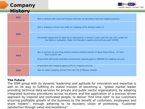
Company<br />
History<br />
2011<br />
Won a contract with Land and Property <strong>Services</strong>, for providing improved mapping services<br />
Won a mapping contract from KMS, for mapping of the Zeeland region of .<br />
2012<br />
Framework agreement for Geoscience extended for a further 5 years upto the year 2017 under the<br />
new Optical, Geospatial, Radar and Elevation supplies and services panel (OGRE).<br />
2013<br />
Won a contract for providing vehicle tracking software solution to Royal Oman Police, , for their<br />
fleet of patrol cars.<br />
Empanelled with South Australian Government mapping agency (DEWNR) for mapping services<br />
Empanelled with mapping agency (LPI) for mapping services<br />
2014<br />
Won an urban mapping contract from the City of Ottawa, Canada