Finalise Design Example
2017 Student Project
2017 Student Project

Create successful ePaper yourself
Turn your PDF publications into a flip-book with our unique Google optimized e-Paper software.
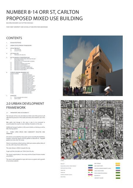
NUMBER 8-14 ORR ST, CARLTON<br />
PROPOSED MIXED USE BUILDING<br />
BUILDING DESIGNER: ALIX SUTTON (S9453362)<br />
YEAR 3 RMIT UNIVERSITY AND SCHOOL OF ARCHITECTURE AND DESIGN<br />
CONTENTS<br />
1. DESIGN RESPONSE<br />
2. URBAN DEVELOPMENT FRAMEWORK<br />
3. SITE & PRECINCT<br />
3.1 SITE LOCATION<br />
3.2 LOCALITY PLAN<br />
4. SITE ANALYSIS<br />
4.1 PROPOSED SITE ANALYSIS<br />
1.0 DESIGN RESPONSE<br />
Alix Sutton <strong>Design</strong> is seeking approval for a proposed<br />
multilevel mixed occupancy building at 8-14 Orr St, Carlton<br />
that will provide a greater level of activities to the area<br />
compared to the currently under utilised warehouse. The<br />
proposal of a 6 storey innovatively designed building will<br />
offer a mix of uses, including community services through the<br />
proposed hot desk spaces and Koori centre. Plus providing<br />
accommodation for families, couples, singles, and students.<br />
The proposed building aims to provide a platform for industry<br />
people and students to interact within the hot desk and<br />
communal area. With this networking opportunity better<br />
preparing students for life beyond and also allowing a<br />
potential space for the new age of start ups to have access to<br />
all their office needs at a low entry rate.<br />
Within our community their are many smaller communities<br />
that need greater support. The inclusion of the Koori Centre<br />
near the entrance of the Carlton precinct will provide a safe<br />
space for all Aboriginal and Torres Strait Islanders. The centre<br />
will provide a fully equipped computer lab, photocopying<br />
facilities, meeting room, and a fully equipped common room.<br />
The Koori Centre will be marked at the entry of 8-14 Orr St by<br />
a Moreton Bay Fig Tree which was in the 1940-1960’s a place of<br />
meeting for the indigenous leaders within the gardens of the<br />
Royal Exhibition Buildings.<br />
Self contained with student accommodation on the ground<br />
floor is proposed to also accommodate visiting family for the<br />
Aboriginal and Torres Strait Islanders. We are also proposing<br />
1,2 and 3 bedroom apartments.<br />
The site at 8-14 Orr St is immediately overshadowed by<br />
number 26 (Uni Lodge), hence providing a design issue as<br />
there was going to be limited light to the site.<br />
Precedent:<br />
Part of the design response was also to provide an innovative<br />
build that could inspire the city dwellers and also respond<br />
to the limitations of building on a city site. The 9 storey Forte<br />
Apartments (refer figure 2) in Melbourne Docklands by Lend<br />
Lease was the first multi story to be built of timber modular<br />
structures that was constructed off-site. This reduced the<br />
inconvenience of construction to the local community. The<br />
Forte apartments were constructed in11 months, with the CLT<br />
installation taking just 3 months. This building system has<br />
been influential in the design.<br />
I have drawn from the nArchitects My Micro NY apartments on<br />
a small plot of land in Manhattan New York. These apartments<br />
are also prefabricated off site but off steel and concrete. I have<br />
also drawn from of these apartment blocks, which is stepped<br />
down on the Southside to allow maximum sun penetration<br />
and also provide roof terrance for occupants to enjoy.<br />
Taking inspiration from both the gritty laneways for Melbourne<br />
and the desire to provide a form that could stand firm in<br />
the ground but provide a lightness and transparency to an<br />
otherwise dense surrounds, my project has evolved. It is to<br />
be a space that will have an active community, that can enjoy<br />
natural light and green surrounds.<br />
5. KEY PLANNING CONSIDERATIONS<br />
5.1 RESPONSE TO MIXED ZONE, PROPOSED PRECINCT<br />
DEVELOPMENT PLAN<br />
RESPONSE TO CITY OF MELBOURNE PLANNING<br />
5.2 RESPONSE TO NCC<br />
5.3 RESPONSE TO MATERIAL SELECTION<br />
5.4 RESPONSE TO SUSTAINABILITY<br />
5.5 RESPONSE TO WASTE MANAGEMENT<br />
5.6 RESPONSE TO ACCESSIBILITY OBJECTIVES<br />
5.7 RESPONSE TO FUNCTIONAL AREA PLANNING<br />
5.8 RESPONSE TO NOISE IMPACT<br />
MARCH 2017<br />
SEE THE FUTURE<br />
Your guided tour to new global design<br />
WINNING BID:<br />
2<br />
2<br />
6. TOWN PLANNING DRAWING SET<br />
DRAWING NUMBER DRAWING TITLE<br />
TP 0.01<br />
PROPOSED BASEMENT<br />
T.P 0.01<br />
PROPOSED GROUND FLOOR<br />
T.P 0.01<br />
PROPOSED FIRST FLOOR<br />
T.P 0.01<br />
PROPOSED SECOND FLOOR<br />
T.P 0.01<br />
PROPOSED THIRD FLOOR<br />
T.P 0.01<br />
PROPOSED FOURTH FLOOR<br />
T.P 0.01<br />
PROPOSED FIFTH FLOOR<br />
T.P 0.02<br />
PROPOSED SIXTH FLOOR<br />
T.P 0.02<br />
PROPOSED ROOF PLAN<br />
TP 0.02<br />
PROPOSED SOUTH ELEVATION<br />
TP 0.02<br />
PROPOSED WEST ELEVATION<br />
TP 0.02<br />
PROPOSED STREETSCAPE<br />
TP 0.03<br />
PROPOSED NORTH ELEVATION<br />
TP 0.03<br />
PROPOSED EAST ELEVATION<br />
T.P 0.04 PROPOSED SECTION 1<br />
T.P 0.04 PROPOSED SECTION 2<br />
THE FIFTH ELEMENT<br />
MEETS THE GRITTY<br />
LANEWAYS OF<br />
TRANSPOTTING. THE<br />
LUST FOR LIFE RISING<br />
UP OUT OF THE<br />
GRUNGE, THROUGH<br />
THE WINDING MAZE OF<br />
CONCRETE AND<br />
NATURE TO THE FREE<br />
TRANSIENT LIFE ABOVE<br />
Figure 1: Concept Montage<br />
Boarding now for:<br />
CARLTON<br />
+<br />
Concept design<br />
sutton s9453362<br />
0407 687 378<br />
Figure 3: nArchitects My Micro NY apartments<br />
Figure 2: Forte Apartments CLT Melbourne<br />
Figure 3: <strong>Design</strong> Sketch of 8-14 Orr St, Carlton<br />
7. APPENDIX<br />
7.1 MCC PLANNING APPLICATION<br />
7.2 GANTT CHART<br />
2.0 URBAN DEVELOPMENT<br />
FRAMEWORK<br />
3.0 SITE & PRECINCT<br />
3.1 SITE LOCATION (DESCRIPTION)<br />
2<br />
Site (Project North)<br />
QUEENSBERRY ST<br />
2.1 TRANSPORT AND ACCESSIBILITY<br />
The inclusion of two new rail stations at ether end of the precinct will<br />
alleviate the pressure on the roads and reduce the need for cars in the<br />
area.<br />
Bike paths and storage in the area is also to be increased to<br />
accommodate the need to meet mobility of students in the area.<br />
Additional transport options in this area include car sharing as well as<br />
bike sharing options<br />
2.2 PUBLIC OPEN SPACES AND COMMUNITY FACILITIES AND<br />
AMENITIES<br />
Orr street is surrounded by many open spaces including the Exhibition<br />
Gardens, University Square and the gardens at Bouverle St. Flagstaff<br />
gardens are also only 1km away.<br />
There is one primary school and two child care centres within 250m of<br />
our site, with many more within 2km’s.<br />
The state Library is 400m’s towards the city.<br />
A gym and the city baths are 150m’s from the site<br />
The closest supermarket is 1km away and the Queen Victoria market<br />
only 500m’s.<br />
The area is well equipped to cope with more occupants and a growth<br />
of university students.<br />
N<br />
LEGEND<br />
3<br />
2<br />
1<br />
Current Proposals for the area City of Melbourne and RMIT are under<br />
discussions to close the west end of Earl St and to demolition of B42,<br />
B95 and in also building 71. This is to increase the open space in the<br />
area.<br />
Within the site we are proposing to redevelop the following<br />
property:<br />
8-14 Orr St, Carlton<br />
76-78 Victoria St, Carlton<br />
20-22 Earl St, Carlton<br />
3.2 LOCALITY PLAN<br />
The site precinct is located to the south of Orr St, east of Lygon St,<br />
north of Victoria St and south of Queensberry see figure 4.<br />
1<br />
2<br />
3<br />
4<br />
3<br />
1 4<br />
2 4<br />
2<br />
4<br />
3<br />
2 1<br />
2<br />
2<br />
1<br />
3<br />
HIGH RISE OVER 8 STOREYS<br />
MID RISE BETWEEN 3 - 8 STOREYS<br />
HERITAGE OVERLAY SITES<br />
SPECIAL BUILDING OVERLAY<br />
PROPOSED BUILDINGS FOR REDUX<br />
PROPOSED SITE<br />
CARDIGAN ST<br />
EARL ST<br />
ORR ST<br />
LYGON ST<br />
PRECINCT<br />
MELBOURNE CENTRAL TRAIN STATIONS<br />
PROPOSED TRAIN STATION<br />
BIKE STORAGE<br />
BIKE SHARE POINTS<br />
CARLTON GARDENS PRIMARY SCHOOL<br />
VICTORIA ST<br />
TRAM STOP<br />
TRAM LINE<br />
SHARED CAR POINT (GO GET)<br />
BIKE PATHES<br />
CHILD CARE CENTRES<br />
ROYAL EXHIBITION GARDENS<br />
BOUVERLE ST<br />
UNIVERSITY SQUARE<br />
FIGURE 5. EXISTING PRECINCT PLAN<br />
FIGURE 6. EXISTING BUILDING<br />
Figure 4.Aerial Plan
4.0 SITE ANALYSIS<br />
Located on the East side off Orr St and extends to the back lane.<br />
The site is a regular shape of 15.5m wide and 20.5 in length, total<br />
of 313sqm and runs to the north boundary of the adjoining<br />
property and to the south boundary abutting the lane. The<br />
site has a fall of 1.7m from the rear Northeast to the south west<br />
corner.<br />
5.0 KEY PLANNING<br />
CONSIDERATIONS<br />
5.1 RESPONSE TO DESIGN SCOPE - URBAN PLANNING CITY NORTH<br />
Response to The City of Melbourne:<br />
LYGON ST<br />
Orr St runs between Victoria St and Earl St and is approximately<br />
12m wide with 3.5m footpaths on each side of the road. There<br />
is a mix of modern high rise and 1970's red brick high rise plus<br />
some low rise buildings. The building directly opposite and<br />
adjoining on the Northside are both 8-10 storeys high.<br />
The main frontage there are no existing trees. There are some<br />
young trees planted along the footpath, which are approximately<br />
3m high.<br />
The only habitable windows are on the north side at 26 Orr st,<br />
Uni House but, are set back 3.4m and do not impact our site as<br />
per clause 55.04.<br />
600M TO TRAIN STATION<br />
3<br />
MIXED ACTIVITIES - Spiritual, Commercial, Retail and Residential Use<br />
Proposed Building 1<br />
Proposed Building 2<br />
Proposed Building 3<br />
{3D} Copy 1<br />
Apartments<br />
Cafe<br />
Innovation<br />
Apartments<br />
Koori Centre<br />
Hot Desk Work Spaces<br />
Apartments<br />
Pop Up Shops<br />
Student Cinema<br />
QUEENSBERRY ST<br />
3<br />
EARL ST<br />
ORR ST<br />
BUILDING 1<br />
3<br />
BUILDING 2<br />
1<br />
2<br />
BUILDING 3<br />
1<br />
VICTORIA ST<br />
Car, bike and pedestrian access from both Earl St and Victoria St.<br />
URBAN STRUCTURE AND BUILD FORM<br />
Constraints:<br />
- Projecting adjoining buildings<br />
Proposed building forms are set to contrast between the high rise of<br />
the city to the south. All buildings are set a 7 storeys (24.5M above<br />
ground )<br />
CARDIGAN ST<br />
- Potential of Overshadowing on South Side<br />
- Limitations of local schools, childcare and kindergartens<br />
Opportunities:<br />
- Excellent opportunity to develop site into a mixed used<br />
building, increasing the variety of people to the area, from<br />
residential living to working life.<br />
SUSTAINABLE TRAFFIC MANAGEMENT AND LEVEL OF CONNECTIVITY<br />
Proposed inclusion of bike storage for public access in buildings 2 &<br />
3. Bike lanes and restricted car traffic use to Orr St & Earl St. Widening<br />
of footpath through<br />
{3D}<br />
Orr St to allow for inclusion of Morton Bay Tree to<br />
be placed outside 8-14 Orr St<br />
1<br />
Public Transport amenities are close by (see Urban Framework)<br />
Proposed community services with Koori Centre, Hot desking spaces<br />
1<br />
2<br />
3<br />
BIKE STORAGE<br />
PROPOSED MORTAN BAY TREE<br />
PROPOSED GREEN COMMUNAL SPACE<br />
PROPOSED BIKE PATH<br />
PROPOSED CAR TRAFFIC RESTRICTIONS<br />
ACTIVATION OF LANEWAYS<br />
- Dual access to the building from frontage at Orr St and rear<br />
lane.<br />
- Close to city amenities<br />
4<br />
Activation of laneways through the precinct, with access to 8-14 Orr<br />
St from the rear.<br />
{3D} Copy 1 Copy 1<br />
- Opportunity to create gateway into Carlton RMIT precinct<br />
with bike paths, {3D} wider pedestrian walk ways and community<br />
areas by 1restricting car access to Earl St only.<br />
24500<br />
24500<br />
PROPOSED BOUNDRY LINE<br />
PROPOSED BOUNDRY LINE<br />
PROPOSED BOUNDRY LINE<br />
PROPOSED BOUNDRY LINE<br />
PROPOSED BOUNDRY LINE<br />
PROPOSED BOUNDRY LINE<br />
PROPOSED BOUNDRY LINE<br />
PROPOSED BOUNDRY LINE<br />
SITE<br />
SITE<br />
5<br />
AERIAL VIEW FROM SOUTH EAST CORNER West View Orr St<br />
{3D} Copy 1 Copy 2 1 Copy 1<br />
1 : 1000<br />
{3D} Copy 1<br />
3<br />
AERIAL VIEW FROM NORTH WEST CORNER<br />
5.2 RESPONSE TO NCC<br />
BUILDING 1<br />
ORR ST FACING SOUTH TO VICTORIA ST<br />
2<br />
West View Orr St<br />
1 : 500<br />
ORR ST FACING NORTH TO EARL ST<br />
1<br />
{3D}<br />
6<br />
Buildings must comply with the National Building Code<br />
with maximum building height 25 metres above ground level<br />
DO NOT SCALE FROM DRAWINGS.<br />
No Setbacks required for this site wall is already on the<br />
USE MARKED DIMENSIONS.<br />
boundary, building envelope will take precedent from existing.<br />
TO BE READ IN CONJUNCTION WITH ALL OTHER<br />
CONSULTANTS DRAWINGS.<br />
THE ARCHITECT IS TO BE IMMEDIATELY NOTIFIED<br />
OF ANY DISCREPANCIES.<br />
COPYRIGHT ON THIS DRAWING RETAINED BY<br />
ARCHITECT.<br />
{3D} Copy 1 Copy 1 Copy 1<br />
Copy 1<br />
Rev Note Date<br />
A<br />
TOWN PLANNING<br />
29/4/17<br />
L6<br />
L5<br />
Client 2 BEDROOM APARTMENTS<br />
L4<br />
L3<br />
L2<br />
L1<br />
GF<br />
B<br />
2 & 3 BEDROOM APARTMENTS<br />
1 & 2 BEDROOM APARTMENTS<br />
Building <strong>Design</strong>er<br />
PROPOSED ROOF GARDEN AND 2 BEDROOM APART-<br />
ALIX SUTTON<br />
PROPOSED HOT DESKS AND 2 BEDROOM APARTMENTS<br />
Student No. - s9453362<br />
PROPOSED COMMUNAL SPACE AND 2 BEDROOM APARTMENTS<br />
Email: s9453362@student.rmit.edu.au<br />
PROPOSED KOORI CENTRE AND STUDENT ACCOMMODA-<br />
Mobile: 0407 687 378<br />
BIKE STORAGE AND CHANGE AREA<br />
DO NOT SCALE FROM DRAWINGS.<br />
USE MARKED DIMENSIONS.<br />
TO BE READ IN CONJUNCTION WITH ALL OTHER<br />
CONSULTANTS DRAWINGS.<br />
THE ARCHITECT IS TO BE IMMEDIATELY NOTIFIED<br />
OF ANY DISCREPANCIES.<br />
COPYRIGHT ON THIS DRAWING RETAINED BY<br />
ARCHITECT.<br />
Rev Note Date<br />
A TOWN PLANNING 29/4/17<br />
Client Building <strong>Design</strong>er Project: RMIT - CARLTON REDUX 2017<br />
ALIX SUTTON<br />
Client: RMIT - ANDREW ROODA<br />
Student No. - s9453362<br />
Email: s9453362@student.rmit.edu.au<br />
Site Address: 8-14 ORR ST, CARLTON<br />
Mobile: 0407 687 378<br />
Drawing Name:<br />
Status:<br />
TOWN PLANNING<br />
Scale :<br />
DWG Number:<br />
PROPOSED BOUNDRY LINE<br />
BUILDING 1<br />
Date:<br />
Revision:<br />
NORTH<br />
L6<br />
L5<br />
L4<br />
L3<br />
PROPOSED BOUNDRY LINE<br />
PROPOSED BOUNDRY LINE<br />
BUILDING 3<br />
24/04/2017 8:58:50 AM<br />
PROPOSED BOUNDRY LINE<br />
24500<br />
L2<br />
L1<br />
GF<br />
B<br />
WEST VIEW OF ORR ST SCALE 1:500<br />
MAXIMUM BUILDING HEIGHT 25M
5.0 KEY PLANNING<br />
CONSIDERATIONS<br />
5.3 RESPONSE TO MATERIAL<br />
5.4 RESPONSE TO SUSTAINABILITY<br />
5.5 RESPONSE TO WASTE MANAGEMENT<br />
5.6 ACCESSIBILITY OBJECTIVES<br />
Cross-laminated timber is produced from industrially<br />
dried spruce boards which are stacked at right angles<br />
and glued together over their layer surfaces in 3, 5,<br />
7 or more board layers. The panels are used as large<br />
wall, floor and roof elements, and are manufactured<br />
with precision cut-outs for doors, windows and<br />
building services.<br />
The grid is based on 10m x 2.5 - 2.75m CLT sheets.<br />
This size can be accommodated by a truck to be<br />
delivered to site and craned to position.<br />
Cross Laminated Timber<br />
(Structure & Internal)<br />
Dressed Timber Battens<br />
(Cladding)<br />
Passive solar control<br />
Water management<br />
Natural light to habitable and work areas<br />
Considered material selection<br />
Self Shading<br />
Projecting balcony's above<br />
provides shading from<br />
summer sun<br />
Renewable Energy<br />
Photovoltaic and flat plate<br />
solar collectors to face North<br />
Waste is conveniently placed at first floor levels of apartments off the<br />
central corridor.<br />
Waste will be dropped via the chute to the ground floor to be easily<br />
removed via the roller door to the laneway.<br />
Ground Floor apartments will have their own Bin for recycling and<br />
general waste.<br />
At Level 3 access with a clear path with a minimum width of 1.2metres<br />
that connects the dwelling entrance to the main bedroom.<br />
The bathroom can be updated down stairs and a stair lift installed to<br />
reach Level 4 living and dining.<br />
There is also a accessible bathroom for general access on Ground Floor<br />
and Level 1.<br />
External Cladding with be dressed timber battens<br />
and Black Zincalume around the core.<br />
Blue Stone Tiles will line the external walls of the<br />
Ground Floor with the glass window front.<br />
Glass with black metal framing will provide lightness<br />
to the building. All glass will be double glazed to<br />
make sure the thermal density is at the highest.<br />
Blue Stone Tile (GF Cladding)<br />
Steel Mullions in Glazing<br />
Zincalume (Black Cladding)<br />
Social Spaces<br />
Both roof terrace and<br />
internal courtyard<br />
provide sunny and<br />
shaded options for<br />
social interaction<br />
Winter Sun<br />
The height of the<br />
adjoining property<br />
to the North<br />
over shadows the<br />
proposed building,<br />
allowing only passive<br />
natural light to the<br />
lower levels. Levels<br />
4-6 should enjoy the<br />
afternoon sun.<br />
Thermal Mass<br />
exposed CLT ceilings<br />
walls and floors<br />
provide an airtight<br />
solution as panels<br />
are fixed together<br />
with reduce airflow<br />
through the system.<br />
The large CLT external<br />
walls reduce the<br />
need for expansive<br />
additional insulation.<br />
Renewable<br />
Energy<br />
treated grey water<br />
reticulation supply<br />
system recycles<br />
water for landscape<br />
irrigation and toilet<br />
flushing<br />
5.7 FUNCTIONAL AREA OBJECTIVES<br />
The entrance to 8-14 Orr st is easily identified from the street. The<br />
entrance is air locked and provides windows onto the street from the<br />
central lift area.<br />
Main Bedrooms and other bedrooms meet minimum standards. Living<br />
spaces are at least 12sqm<br />
Balcony spaces are smaller than the proposed but as there is access to<br />
a communal roof top garden with BBQ's and setting.<br />
All apartments have access to a secure storage space in the basement.<br />
- 1 bedroom 10 cubic metres<br />
- 2 bedroom 14 cubic metres<br />
- 3 bedroom 18 cubic metres<br />
5.8 NOISE IMPACTS OBJECTIVES<br />
Noise has been minimised to the bedrooms by having the majority placed<br />
away from the core. Where bedrooms are placed near lifts or stairs,<br />
additional sound proofing will be used. The selection of CLT is rated as<br />
having a very high level of acoustic protection.<br />
The offsite noise will be blocked by surrounding buildings but also the<br />
limited windows on the south side to block noise from Victoria Street.<br />
Source: <strong>Example</strong> of Sustainable Apartment <strong>Design</strong> MCC<br />
Water Storage<br />
roof storage tanks.<br />
All bedrooms have built in robes and storage areas to be built in over<br />
kitchens and bathrooms. Habitable rooms are all have a window or a<br />
door onto an open space. All functional living areas are ordinate to<br />
the North.<br />
Roof Terrace<br />
81 m²<br />
Apartment 4<br />
67 m²<br />
2<br />
12 sqm<br />
UP<br />
Apartment 5<br />
67 m²<br />
12 sqm<br />
3.4 x 3<br />
2<br />
3.3 x 3<br />
2 2<br />
2<br />
A/C<br />
A/C<br />
Waste<br />
1 1<br />
Waste<br />
UP<br />
Apartment UP 5<br />
7 m²<br />
A/C<br />
2<br />
A/C<br />
12+ sqm<br />
UP<br />
Apartment 6<br />
69 m²<br />
Apartment 6<br />
39 m²<br />
3.1 x 5<br />
3.1 x 3.7<br />
2<br />
9AM SPRING EQUINOX 1PM SPRING EQUINOX 3PM SPRING EQUINOX<br />
2<br />
A107<br />
LEVEL 3<br />
SCALE 1 : 100<br />
Accessibility Objective<br />
1 Waste Management<br />
LEVEL 4<br />
5<br />
A107 SCALE 1 : 100<br />
2 Functional Layout Objective Window and Natural Ventilation Objective<br />
PROPOSED SHADOW<br />
Noise Impacts Objectives<br />
EXISTING SHADOW
T P 0 4<br />
T P 0 4<br />
T P 0 4<br />
T P 0 4<br />
T P 0 4<br />
T P 0 4 T P 0 4<br />
T P O 4<br />
T P 0 4<br />
T P 0 4<br />
T P 0 4<br />
T P 0 4<br />
T P O 4
Office Use Onl<br />
Application No.: Date Lodged: / /<br />
Application for a Planning Permit<br />
If you need help to complete this form, read MORE INFORMATION at the end of this form.<br />
Planning Enquiries<br />
Phone: (03) 9658 9658<br />
Web: www.melbourne.vic.gov.au<br />
i<br />
Any material submitted with this application, including plans and personal information, will be made<br />
available for public viewing, including electronically, and copies may be made for interested parties for<br />
the purpose of enabling consideration and review as part of a planning process under the Planning<br />
and Environment Act 1987. If you have any questions, please contact Council’s planning department.<br />
Questions marked with an asterisk (*) must be completed.<br />
If the space provided on the form is insufficient, attach a separate sheet<br />
Click for further information.<br />
The Land i<br />
Address of the land. Complete the Street Address and one of the Formal Land Descriptions.<br />
Street Address *<br />
Unit No.:<br />
St. No.:<br />
St. Name:<br />
Suburb/Locality:<br />
Postcode:<br />
Formal Land Description *<br />
Complete either A or B.<br />
This information can be<br />
found on the certificate<br />
of title.<br />
If this application relates to more than<br />
one address, attach a separate sheet<br />
setting out any additional property<br />
details.<br />
A Lot No.:<br />
Lodged Plan Title Plan Plan of Subdivision<br />
OR<br />
B Crown Allotment No.: Section No.:<br />
Parish/Township Name:<br />
No.:<br />
The Proposal<br />
You must give full details of your proposal and attach the information required to assess the application.<br />
Insufficient or unclear information will delay your application<br />
i<br />
For what use, development<br />
or other matter do you<br />
require a permit? *<br />
Provide additional information about the proposal, including: plans and elevations; any information required by the<br />
planning scheme, requested by Council or outlined in a Council planning permit checklist; and if required, a description<br />
of the likely effect of the proposal.<br />
i<br />
Estimated cost of any<br />
development for which the<br />
permit is required *<br />
Cost $<br />
You may be required to verify this estimate.<br />
Insert ‘0’ if no development is proposed.<br />
If the application is for land within metropolitan Melbourne (as defined in section 3 of the Planning and Environment Act 1987)<br />
and the estimated cost of the development exceeds $1 million (adjusted annually by CPI) the Metropolitan Planning Levy must<br />
be paid to the State Revenue Office and a current levy certific e must be submitted with the application.<br />
Visit www.sro.vic.gov.au for information.<br />
Application for a Planning Permit | Metropolitan Council Page 1
Existing Conditions i<br />
Describe how the land is<br />
used and developed now *<br />
For example, vacant, three<br />
dwellings, medical centre with<br />
two practitioners, licensed<br />
restaurant with 80 seats,<br />
grazing.<br />
Provide a plan of the existing conditions. Photos are also helpful.<br />
Title Information i<br />
Encumbrances on title *<br />
Does the proposal breach, in any way, an encumbrance on title such as a restrictrive covenant,<br />
section 173 agreement or other obligation such as an easement or building envelope?<br />
Yes (If ‘yes’ contact Council for advice on how to proceed before continuing with this<br />
application.)<br />
No<br />
Not applicable (no such encumbrance applies).<br />
Provide a full, current copy of the title for each individual parcel of land forming the subject site.<br />
The title includes: the covering ‘register search statement’, the title diagram and the associated title documents, known<br />
as ‘instruments’, for example, restrictive covenants.<br />
Applicant and Owner Details<br />
i<br />
Provide details of the applicant and the owner of the land.<br />
Applicant *<br />
The person who wants the<br />
permit.<br />
Name:<br />
Title: First Name: Surname:<br />
Organisation (if applicable):<br />
Postal Address:<br />
Unit No.:<br />
St. No.:<br />
If it is a P.O. Box, enter the details here:<br />
St. Name:<br />
Suburb/Locality:<br />
State:<br />
Postcode:<br />
Please provide at least one<br />
contact phone number *<br />
Contact information for applicant OR contact person below<br />
Business phone:<br />
Email:<br />
Mobile phone:<br />
Fax:<br />
Where the preferred contact<br />
person for the application is<br />
different from the applicant,<br />
provide the details of that<br />
person.<br />
Contact person’s details*<br />
Name:<br />
Title: First Name: Surname:<br />
Organisation (if applicable):<br />
Same as applicant<br />
Postal Address:<br />
Unit No.:<br />
St. No.:<br />
If it is a P.O. Box, enter the details here:<br />
St. Name:<br />
Suburb/Locality:<br />
State:<br />
Postcode:<br />
Owner *<br />
The person or organisation<br />
who owns the land<br />
Name:<br />
Title: First Name: Surname:<br />
Same as applicant<br />
Where the owner is different<br />
from the applicant, provide<br />
the details of that person or<br />
organisation.<br />
Organisation (if applicable):<br />
Postal Address:<br />
Unit No.: St. No.:<br />
If it is a P.O. Box, enter the details here:<br />
St. Name:<br />
Suburb/Locality:<br />
State:<br />
Postcode:<br />
Owner’s Signature (Optional):<br />
Date:<br />
day / month / year<br />
Application for a Planning Permit | Metropolitan Council Page 2
Declaration i<br />
This form must be signed by the applicant *<br />
Remember it is against<br />
the law to provide false or<br />
misleading information,<br />
which could result in a<br />
heavy fine and cancellatio<br />
of the permit.<br />
I declare that I am the applicant; and that all the information in this application is true and<br />
correct; and the owner (if not myself) has been notified of the permit application.<br />
Signature:<br />
Date:<br />
day / month / year<br />
Need help with the Application?<br />
General information about the planning process is available at planning.vic.gov.au<br />
i<br />
Contact Council’s planning department to discuss the specific requirements for his application and obtain a planning permit checklist.<br />
Insufficient or unclear information may delay your application<br />
Has there been a<br />
pre-application meeting<br />
with a council planning<br />
officer<br />
No Yes If ‘Yes’, with whom?:<br />
Date:<br />
day / month / year<br />
Checklist i<br />
Have you:<br />
Filled in the form completely?<br />
Paid or included the application fee?<br />
Most applications require a fee to be paid. Contact Council<br />
to determine the appropriate fee.<br />
Provided all necessary supporting information and documents?<br />
A full, current copy of title information for each individual parcel of land forming the subject site.<br />
A plan of existing conditions.<br />
Plans showing the layout and details of the proposal.<br />
Any information required by the planning scheme, requested by council or outlined in a council planning permit checklist.<br />
If required, a description of the likely effect of the proposal (for example, traffic, noise, environmental impacts)<br />
If applicable, a current Metropolitan Planning Levy certificate (a levy certificate expires 90 days after the day on which it i<br />
issued by the State Revenue Office and then cannot be used). Failure to comply means the application is void<br />
Completed the relevant council planning permit checklist?<br />
Signed the declaration?<br />
Lodgement<br />
Lodge the completed and<br />
signed form, the fee and all<br />
documents with:<br />
i<br />
By Post:<br />
Planning Department<br />
City of Melbourne<br />
PO Box 1603<br />
Melbourne VIC 3001<br />
In Person:<br />
Council House 2<br />
240 Little Collins Street<br />
Melbourne VIC 3000<br />
Contact information:<br />
Phone: (03) 9658 9658<br />
Fax: (03) 9654 4854<br />
Email: planning@melbourne.vic.gov.au<br />
DX: 210487<br />
Translation: Amharic (03) 9280 0716, Cantonese (03) 9280 0717, Greek (03) 9280 0718,<br />
Indonesian (03) 9280 0719, Italian (03) 9280 0720, Mandarin (03) 9280 0721, Somali (03) 9280 0722,<br />
Spanish (03) 9280 0723, Turkish (03) 9280 0724, Vietnamese (03) 9280 0725 and all other languages<br />
(03) 9280 0726<br />
Deliver application in person, by post or by electronic lodgement.<br />
Application for a Planning Permit | Metropolitan Council Page 3
i MORE INFORMATION<br />
The Land<br />
Planning permits relate to the use and development of the land. It is<br />
important that accurate, clear and concise details of the land are provided<br />
with the application.<br />
How is land identified<br />
Land is commonly identified by a street address, but sometimes this<br />
alone does not provide an accurate identification of the relevant parcel<br />
of land relating to an application. Make sure you also provide the<br />
formal land description - the lot and plan number or the crown, section<br />
and parish/township details (as applicable) for the subject site. This<br />
information is shown on the title.<br />
See <strong>Example</strong> 1.<br />
The Proposal<br />
Why is it important to describe the proposal correctly?<br />
The application requires a description of what you want to do with the<br />
land. You must describe how the land will be used or developed as a<br />
result of the proposal. It is important that you understand the reasons why<br />
you need a permit in order to suitably describe the proposal. By providing<br />
an accurate description of the proposal, you will avoid unnecessary<br />
delays associated with amending the description at a later date.<br />
Planning schemes use specific definitions for different types of use<br />
and development. Contact the Council planning office at an early stage<br />
in preparing your application to ensure that you use the appropriate<br />
terminology and provide the required details.<br />
How do planning schemes affect proposals?<br />
A planning scheme sets out policies and requirements for the use,<br />
development and protection of land. There is a planning scheme for every<br />
municipality in Victoria. Development of land includes the construction<br />
of a building, carrying out works, subdividing land or buildings and<br />
displaying signs.<br />
Proposals must comply with the planning scheme provisions in<br />
accordance with Clause 61.05 of the planning scheme. Provisions may<br />
relate to the State Planning Policy Framework, the Local Planning Policy<br />
Framework, zones, overlays, particular and general provisions. You can<br />
access the planning scheme by either contacting Council’s planning<br />
department or by visiting Planning Schemes Online at<br />
planning-schemes.delwp.vic.gov.au<br />
You can obtain a planning certificate to establish planning scheme<br />
details about your property. A planning certificate identifies the zones an<br />
overlays that apply to the land, but it does not identify all of the provisions<br />
of the planning scheme that may be relevant to your application. Planning<br />
certificates for land in metropolitan areas and most rural areas can be<br />
obtained by visiting www.landata.vic.gov.au Contact your local Council to<br />
obtain a planning certificate in Central Gol fields, Corangamite, Macedon<br />
Ranges and Greater Geelong. You can also use the free Planning<br />
Property Report to obtain the same information.<br />
See <strong>Example</strong> 2.<br />
Estimated cost of development<br />
In most instances an application fee will be required. This fee must be<br />
paid when you lodge the application. The fee is set down by government<br />
regulations.<br />
To help Council calculate the application fee, you must provide an<br />
accurate cost estimate of the proposed development. This cost does<br />
not include the costs of development that you could undertake without a<br />
permit or that are separate from the permit process. Development costs<br />
should be calculated at a normal industry rate for the type of construction<br />
you propose.<br />
Council may ask you to justify your cost estimates. Costs are required<br />
solely to allow Council to calculate the permit application fee. Fees are<br />
exempt from GST.<br />
Costs for different types of development can be obtained from<br />
specialist publications such as Cordell Housing: Building Cost Guide or<br />
Rawlinsons: Australian Construction Handbook.<br />
Contact the Council to determine the appropriate fee. Go to<br />
planning.vic.gov.au to view a summary of fees in the Planning and<br />
Environment (Fees) Regulations.<br />
Metropolitan Planning Levy refer Division 5A of Part 4 of the Planning<br />
and Environment Act 1987 (the Act). A planning permit application under<br />
section 47 or 96A of the Act for a development of land in metropolitan<br />
Melbourne as defined in section 3 of the Act may be a leviable<br />
application. If the cost of the development exceeds the threshold of<br />
$1 million (adjusted annually by consumer price index) a levy certificate<br />
must be obtained from the State Revenue Office after payment of the<br />
levy. A valid levy certificate must be submitted to the responsible planning<br />
authority (usually council) with a leviable planning permit application.<br />
Refer to the State Revenue Office website at www.sro.vic.gov.au for more<br />
information. A leviable application submitted without a levy certificate is<br />
void.<br />
Existing Conditions<br />
How should land be described?<br />
You need to describe, in general terms, the way the land is used now,<br />
including the activities, buildings, structures and works that exist (e.g.<br />
single dwelling, 24 dwellings in a three-storey building, medical centre<br />
with three practitioners and 8 car parking spaces, vacant building, vacant<br />
land, grazing land, bush block).<br />
Please attach to your application a plan of the existing conditions of the<br />
land. Check with the local Council for the quantity, scale and level of<br />
detail required. It is also helpful to include photographs of the existing<br />
conditions.<br />
See <strong>Example</strong> 3.<br />
Title Information<br />
What is an encumbrance?<br />
An ‘encumbrance’ is a formal obligation on the land, with the most<br />
common type being a ‘mortgage’. Other common examples of<br />
encumbrances include:<br />
• Restrictive Covenants: A ‘restrictive covenant’ is a written agreement<br />
between owners of land restricting the use or development of the land<br />
for the benefit of others, (eg. a limit of one dwelling or limits on types o<br />
building materials to be used).<br />
• Section 173 Agreements: A ‘section 173 agreement’ is a contract<br />
between an owner of the land and the Council which sets out<br />
limitations on the use or development of the land.<br />
• Easements: An ‘easement’ gives rights to other parties to use the land<br />
or provide for services or access on, under or above the surface of the<br />
land.<br />
• Building Envelopes: A ‘building envelope’ defines the developmen<br />
boundaries for the land.<br />
Aside from mortgages, the above encumbrances can potentially limit or<br />
even prevent certain types of proposals.<br />
What documents should I check to find encumbrances<br />
Encumbrances are identified on the title (register search statement) under<br />
the header ‘encumbrances, caveats and notices’. The actual details of an<br />
encumbrance are usually provided in a separate document (instrument)<br />
associated with the title. Sometimes encumbrances are also marked on<br />
the title diagram or plan, such as easements or building envelopes.<br />
What about caveats and notices?<br />
A ‘caveat’ is a record of a claim from a party to an interest in the land.<br />
Caveats are not normally relevant to planning applications as they<br />
typically relate to a purchaser, mortgagee or chargee claim, but can<br />
sometimes include claims to a covenant or easement on the land. These<br />
types of caveats may affect your proposal.<br />
Other less common types of obligations may also be specified on title in<br />
the form of ‘notices’. These may have an effect on your proposal, such as<br />
a notice that the building on the land is listed on the Heritage Register.<br />
What happens if the proposal contravenes an encumbrance on title?<br />
Encumbrances may affect or limit your proposal or prevent it from<br />
proceeding. Section 61(4) of the Planning and Environment Act 1987 for<br />
example, prevents a Council from granting a permit if it would result in a<br />
breach of a registered restrictive covenant. If the proposal contravenes<br />
any encumbrance, contact the Council for advice on how to proceed.<br />
Application for a Planning Permit | Metropolitan Council<br />
Addendum
You may be able to modify your proposal to respond to the issue. If<br />
not, separate procedures exist to change or remove the various types<br />
of encumbrances from the title. The procedures are generally quite<br />
involved and if the encumbrance relates to more than the subject<br />
property, the process will include notice to the affected party.<br />
You should seek advice from an appropriately qualified person, such<br />
as a solicitor, if you need to interpret the effect of an encumbrance or if<br />
you seek to amend or remove an encumbrance.<br />
Why is title information required?<br />
Title information confirms the location and dimensions of the land<br />
specified in the planning application and any obligations a fecting what<br />
can be done on or with the land.<br />
As well as describing the land, a full copy of the title will include a<br />
diagram or plan of the land and will identify any encumbrances, caveats<br />
and notices.<br />
What is a ‘full’ copy of the title?<br />
The title information accompanying your application must include a<br />
‘register search statement’ and the title diagram, which together make up<br />
the title.<br />
In addition, any relevant associated title documents, known as<br />
‘instruments’, must also be provided to make up a full copy of the title.<br />
Check the title to see if any of the types of encumbrances, such as<br />
a restrictive covenant, section 173 agreement, easement or building<br />
envelope, are listed. If so, you must submit a copy of the document<br />
(instrument) describing that encumbrance. Mortgages do not need to be<br />
provided with planning applications.<br />
Some titles have not yet been converted by Land Registry into an<br />
electronic register search statement format. In these earlier types of<br />
titles, the diagram and encumbrances are often detailed on the actual<br />
title, rather than in separate plans or instruments.<br />
Why is ‘current’ title information required?<br />
It is important that you attach a current copy of the title for each<br />
individual parcel of land forming the subject site. ‘Current’ title<br />
information accurately provides all relevant and up-to-date information.<br />
Some councils require that title information must have been searched<br />
within a specified time frame. Contact the Council for advice on their<br />
requirements.<br />
Copies of title documents can be obtained from Land Registry: Level<br />
10, 570 Bourke Street, Melbourne; 03 8636 2010; www.landata.vic.gov.<br />
au – go direct to “titles & property certificates”<br />
Applicant and Owner Details<br />
This section provides information about the permit applicant, the owner<br />
of the land and the person who should be contacted about any matters<br />
concerning the permit application.<br />
The applicant is the person or organisation that wants the permit. The<br />
applicant can, but need not, be the contact person.<br />
In order to avoid any confusion, the Council will communicate only<br />
with the person who is also responsible for providing further details.<br />
The contact may be a professional adviser (e.g. architect or planner)<br />
engaged to prepare or manage the application. To ensure prompt<br />
communications, contact details should be given.<br />
Check with Council how they prefer to communicate with you about the<br />
application. If an email address is provided this may be the preferred<br />
method of communication between council and the applicant/contact.<br />
Declaration<br />
The declaration should be signed by the person who takes responsibility<br />
for the accuracy of all the information that is provided. This declaration is<br />
a signed statement that the information included with the application is<br />
true and correct at the time of lodgement.<br />
The declaration can be signed by the applicant or owner. If the owner is<br />
not the applicant, the owner must either sign the application form or must<br />
be notified of the application which is acknowledged in the declaration<br />
Obtaining or attempting to obtain a permit by wilfully making or<br />
causing any false representation or declaration, either orally or in writing,<br />
is an offence under the Planning and Environment Act 1987 and could<br />
result in a fine and/or cancellation of the permit<br />
Need help with the Application?<br />
If you have attended a pre-application meeting with a Council planner,<br />
fill in the name of the planner and the date, so that the person can be<br />
consulted about the application once it has been lodged.<br />
Checklist<br />
What additional information should you provide to support the<br />
proposal?<br />
You should provide sufficient supporting material with the application<br />
to describe the proposal in enough detail for the Council to make a<br />
decision. It is important that copies of all plans and information submitted<br />
with the application are legible.<br />
There may be specific application requirements set out in the planning<br />
scheme for the use or development you propose. The application should<br />
demonstrate how these have been addressed or met.<br />
The checklist is to help ensure that you have:<br />
• provided all the required information on the form<br />
• included payment of the application fee<br />
• attached all necessary supporting information and documents<br />
• completed the relevant Council planning permit checklist<br />
• signed the declaration on the last page of the application form<br />
The more complete the information you provide with your permit<br />
application, the sooner Council will be able to make a decision.<br />
Lodgement<br />
The application must be lodged with the Council responsible for the<br />
planning scheme in which the land affected by the application is<br />
located. In some cases the Minister for Planning or another body is the<br />
responsible authority instead of Council. Ask the Council if in doubt.<br />
Check with Council how they prefer to have the application lodged. For<br />
example, they may have an online lodgement system, prefer email or<br />
want an electronic and hard copy. Check also how many copies of plans<br />
and the size of plans that may be required.<br />
Contact details are listed in the lodgement section on the last page of the<br />
form.<br />
Approval from other authorities: In addition to obtaining a planning<br />
permit, approvals or exemptions may be required from other authorities<br />
or Council departments. Depending on the nature of your proposal,<br />
these may include food or health registrations, building permits or<br />
approvals from water and other service authorities.<br />
The owner of the land is the person or organisation who owns the land at<br />
the time the application is made. Where a parcel of land has been sold<br />
and an application made prior to settlement, the owner’s details should<br />
be identified as those of the vendo . The owner can, but need not, be the<br />
contact or the applicant.<br />
See <strong>Example</strong> 4.<br />
Application for a Planning Permit | Metropolitan Council<br />
Addendum
EXAMPLES<br />
<strong>Example</strong> 1<br />
The Land i<br />
Address of the land. Complete the Street Address and one of the Formal Land Descriptions.<br />
Street Address *<br />
Formal Land Description *<br />
Complete either A or B.<br />
This information can be<br />
found on the certificate<br />
of title.<br />
If this application relates to more than<br />
one address, attach a separate sheet<br />
setting out any additional property<br />
details.<br />
4 26 Planmore Avenue<br />
Unit No.:<br />
St. No.:<br />
St. Name:<br />
Suburb/Locality:<br />
HAWTHORN Postcode: 3122<br />
A Lot No.: 2<br />
Lodged Plan Title Plan PPlan of Subdivision No.: LP93562<br />
OR<br />
B Crown Allotment No.: Section No.:<br />
Parish/Township Name:<br />
<strong>Example</strong> 2<br />
i<br />
For what use, development<br />
or other matter do you<br />
require a permit? *<br />
Construction of two, double-storey dwellings<br />
and construction of two new crossovers.<br />
Provide additional information about the proposal, including: plans and elevations; any information required by the<br />
planning scheme, requested by Council or outlined in a Council planning permit checklist; and if required, a description<br />
of the likely effect of the proposal.<br />
<strong>Example</strong> 3<br />
Existing Conditions i<br />
Describe how the land is<br />
used and developed now *<br />
For example, vacant, three<br />
dwellings, medical centre with<br />
two practitioners, licensed<br />
restaurant with 80 seats,<br />
grazing.<br />
Single dwelling.<br />
Provide a plan of the existing conditions. Photos are also helpful.<br />
<strong>Example</strong> 4<br />
Applicant and Owner Details<br />
i<br />
Provide details of the applicant and the owner of the land.<br />
Applicant *<br />
Name:<br />
The person who wants the<br />
Title: Mr First Name: Len Surname: Browning<br />
permit.<br />
Organisation (if applicable): Responsible Developers P/L<br />
Postal Address:<br />
If it is a P.O. Box, enter the details here:<br />
Unit No.: 4 St. No.: 12 St. Name: Ardour Lane<br />
Suburb/Locality:<br />
Wycheproof State: Vic Postcode: 3527<br />
Please provide at least one<br />
contact phone number *<br />
Where the preferred contact<br />
person for the application is<br />
different from the applicant,<br />
provide the details of that<br />
person.<br />
Owner *<br />
The person or organisation<br />
who owns the land<br />
Contact information for applicant OR contact person below<br />
Business phone:<br />
9123 4567<br />
Email: tcpl@bigpond.net.au<br />
Mobile phone:<br />
Fax:<br />
0412 345 678 9123 4567<br />
Contact person’s details*<br />
Same as applicant<br />
Name:<br />
Title: First Name: Surname:<br />
Organisation (if applicable):<br />
Postal Address:<br />
Mr Andrew Hodge<br />
Town Planning Consultants<br />
If it is a P.O. Box, enter the details here:<br />
PO Box 111<br />
Unit No.: St. No.:<br />
St. Name:<br />
Suburb/Locality: Parkdale State: Vic Postcode: 3194<br />
Same as applicant<br />
Name:<br />
Title: First Name: Surname:<br />
P<br />
Where the owner is different<br />
from the applicant, provide<br />
the details of that person or<br />
organisation.<br />
Organisation (if applicable):<br />
Postal Address:<br />
Unit No.: St. No.:<br />
If it is a P.O. Box, enter the details here:<br />
St. Name:<br />
Suburb/Locality:<br />
State:<br />
Postcode:<br />
Owner’s Signature (Optional):<br />
Date:<br />
day / month / year<br />
Application for a Planning Permit | Metropolitan Council<br />
Addendum
Powered by TCPDF (www.tcpdf.org)<br />
Feb '17 Mar '17 Apr '17 May '17 Jun '17<br />
5 12 19 26 5 12 19 26 2 9 16 23 30 7 14 21 28 4<br />
RMIT Year 3 0h 72%<br />
0h 0%<br />
0 0%<br />
0 0%<br />
0 0%<br />
0 0%<br />
Milestone 1 0 0%<br />
<strong>Design</strong> Concept 0h 100%<br />
Collage and Mind Map 0 100%<br />
Massing Study 0 100%<br />
Solar Study 0 100%<br />
Ground Floor Plan 0 100%<br />
Third Floor Plan 0 100%<br />
Elevations 0 100%<br />
Section 0 100%<br />
Concept <strong>Design</strong> Poster 10% 0 100%<br />
<strong>Finalise</strong> <strong>Design</strong> 0h 98%<br />
Structural Grid 0 100%<br />
Basement Floor Plan 0 100%<br />
Ground Floor Plan 0 100%<br />
1st Floor Plan 0 100%<br />
2nd Floor Plan 0 100%<br />
3rd Floor Plan 0 100%<br />
4th Floor Plan 0 100%<br />
5th Floor Plan 0 100%<br />
6th Floor Plan 0 100%<br />
7th Floor Plan 0 100%<br />
<strong>Finalise</strong> <strong>Design</strong> 0 100%<br />
Town Planning Application h 0%<br />
<strong>Design</strong> Reponse 0 100%<br />
Urban Development Framwork (PreD) 0 100%<br />
Site & Precinct 0 100%<br />
Site Analysis 0 100%<br />
<strong>Finalise</strong> Floor Plans 0 100%<br />
Section 1:100 x 2 0 100%<br />
Elevations x 4 0 100%<br />
Streetscape 0 100%<br />
ESD compliance with MCC C122.19 0 100%<br />
Material & Finishes 0 100%<br />
Shadow Diagrames 0 100%<br />
Area Anaylsis 0 100%<br />
3D rendered exterior view 0 100%<br />
Appendix ie car lift 0 0%<br />
Completted Gant Chart 0 100%<br />
MCC Town Planning Application 0 100%<br />
Compile in Indesign 0 100%<br />
Town Planning Application Submissi... 0 100%<br />
Construction Documentation 0h 0%<br />
Final Construction Documenation 0 0%<br />
Final Project Submission 0h 0%<br />
Final Folio 0 0%<br />
Exhibition Documentation 0h 0%<br />
Exhibition 0 0%<br />
Alix Sutton<br />
Alix Sutton<br />
Alix Sutton<br />
Alix Sutton<br />
Alix Sutton<br />
Alix Sutton<br />
Alix Sutton<br />
Alix Sutton<br />
Alix Sutton<br />
Alix Sutton<br />
Alix Sutton<br />
Alix Sutton<br />
Alix Sutton<br />
Alix Sutton<br />
Alix Sutton<br />
Alix Sutton<br />
Alix Sutton<br />
Alix Sutton<br />
Alix Sutton<br />
Alix Sutton<br />
Alix Sutton<br />
Alix Sutton<br />
Alix Sutton<br />
Alix Sutton<br />
Alix Sutton<br />
Alix Sutton<br />
Alix Sutton<br />
Alix Sutton<br />
Alix Sutton<br />
Alix Sutton<br />
Alix Sutton<br />
Alix Sutton<br />
Alix Sutton<br />
Alix Sutton<br />
Alix Sutton<br />
Alix Sutton<br />
Alix Sutton