Winter 2006 - Missouri Department of Natural Resources
Winter 2006 - Missouri Department of Natural Resources
Winter 2006 - Missouri Department of Natural Resources

Create successful ePaper yourself
Turn your PDF publications into a flip-book with our unique Google optimized e-Paper software.
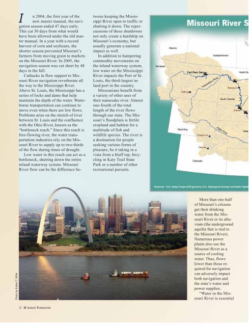
Photo by Robert T. Miller<br />
I n 2004, the first year <strong>of</strong> the<br />
new master manual, the navigation<br />
season ended 47 days early.<br />
This cut 30 days from what would<br />
have been allowed under the old master<br />
manual. In a year with a record<br />
harvest <strong>of</strong> corn and soybeans, the<br />
shorter season prevented <strong>Missouri</strong>’s<br />
farmers from moving grain to markets<br />
on the <strong>Missouri</strong> River. In 2005, the<br />
navigation season was cut short by 48<br />
days in the fall.<br />
Cutbacks in flow support to <strong>Missouri</strong><br />
River navigation reverberate all<br />
the way to the Mississippi River.<br />
Above St. Louis, the Mississippi has a<br />
series <strong>of</strong> locks and dams that help<br />
maintain the depth <strong>of</strong> the water. Waterborne<br />
transportation can continue to<br />
move even when there are low flows.<br />
Problems arise on the stretch <strong>of</strong> river<br />
between St. Louis and the confluence<br />
with the Ohio River, known as the<br />
“bottleneck reach.” Since this reach is<br />
free-flowing river, the water transportation<br />
industries rely on the <strong>Missouri</strong><br />
River to supply up to two-thirds<br />
<strong>of</strong> the flow during times <strong>of</strong> drought.<br />
Low water in this reach can act as a<br />
bottleneck, shutting down the entire<br />
inland waterway system. <strong>Missouri</strong><br />
River flow can be the difference be-<br />
12 <strong>Missouri</strong> <strong>Resources</strong><br />
tween keeping the Mississippi<br />
River open to traffic or<br />
shutting it down. The repercussions<br />
<strong>of</strong> these shutdowns<br />
not only create a hardship on<br />
<strong>Missouri</strong>’s economy, but<br />
usually generate a national<br />
impact as well.<br />
In addition to hampering<br />
commodity movements on<br />
the inland waterway system,<br />
low water on the Mississippi<br />
River impacts the Port <strong>of</strong> St.<br />
Louis, the third-largest inland<br />
port in the country.<br />
<strong>Missouri</strong>ans benefit from<br />
a variety <strong>of</strong> other uses <strong>of</strong><br />
their namesake river. Almost<br />
one-fourth <strong>of</strong> the total<br />
length <strong>of</strong> the river flows<br />
through our state. The <strong>Missouri</strong>’s<br />
floodplain is fertile<br />
cropland and habitat for a<br />
multitude <strong>of</strong> fish and<br />
wildlife species. The river is<br />
a destination for people<br />
seeking various forms <strong>of</strong><br />
pleasure, be it taking in a<br />
vista from a bluff top, bicycling<br />
in Katy Trail State<br />
Park or a number <strong>of</strong> other<br />
recreational pursuits.<br />
More than one-half<br />
<strong>of</strong> <strong>Missouri</strong>’s citizens<br />
get their drinking<br />
water from the <strong>Missouri</strong><br />
River or its alluvium<br />
(the underground<br />
aquifer that is tied to<br />
the <strong>Missouri</strong> River).<br />
Numerous power<br />
plants also use the<br />
<strong>Missouri</strong> River as a<br />
source <strong>of</strong> cooling<br />
water. Thus, flows<br />
lower than those required<br />
for navigation<br />
can adversely impact<br />
both navigation and<br />
the state’s water and<br />
power supplies.<br />
“Water in the <strong>Missouri</strong><br />
River is essential