

Evaluation of desertification hazard in the Jaz_Murian aquifer based on analysis of climate and groundwater criteria
Abstract Desertification is a major concern of this century and occurs as a result of climatic and human induced factors. The current work aims to depict the desertification hazard map in the Jaz_Murian region using an Iranian Model of Desertification Potential Assessment (IMDPA) based on groundwater and climate criteria. For the evaluation of groundwater criterion, four indices included Electrical Conductive (Ec), Sodium Absorption Ratio (SAR), Chloride (CL), and groundwater depletion are usually used. As well as, two climatic (precipitation and aridity) indices were considered. As the groundwater quality data are collected in a much-dispersed network of wells, this problem is moderated by various geostatistical methods that have been developed to predict values at the unmeasured locations. This paper used Kriging's method to interpolate groundwater quality variables. In order to better understanding the groundwater level of Jaz_Murian aquifer, the groundwater hydrograph was generated. The results showed that the groundwater level depleted about 6.8 meter during the last 11 years. Moreover, evaluation of desertification based on climatic indices showed that the Jaz_Murian aquifer faces a critical desertification hazard. Results have shown that about 49% of the area fell into the moderate category and the rest (51%) fell into the high category for desertification hazard. Decrease in precipitation and severe utilization of groundwater particularly in the agricultural sector led to desertification that calls for urgent establishment of watershed management projects in this region.
Abstract
Desertification is a major concern of this century and occurs as a result of climatic and human induced factors. The current work aims to depict the desertification hazard map in the Jaz_Murian region using an Iranian Model of Desertification Potential Assessment (IMDPA) based on groundwater and climate criteria. For the evaluation of groundwater criterion, four indices included Electrical Conductive (Ec), Sodium Absorption Ratio (SAR), Chloride (CL), and groundwater depletion are usually used. As well as, two climatic (precipitation and aridity) indices were considered. As the groundwater quality data are collected in a much-dispersed network of wells, this problem is moderated by various geostatistical methods that have been developed to predict values at the unmeasured locations. This paper used Kriging's method to interpolate groundwater quality variables. In order to better understanding the groundwater level of Jaz_Murian aquifer, the groundwater hydrograph was generated. The results showed that the groundwater level depleted about 6.8 meter during the last 11 years. Moreover, evaluation of desertification based on climatic indices showed that the Jaz_Murian aquifer faces a critical desertification hazard. Results have shown that about 49% of the area fell into the moderate category and the rest (51%) fell into the high category for desertification hazard. Decrease in precipitation and severe utilization of groundwater particularly in the agricultural sector led to desertification that calls for urgent establishment of watershed management projects in this region.

Create successful ePaper yourself
Turn your PDF publications into a flip-book with our unique Google optimized e-Paper software.
J. Bio. & Env. Sci. 2016<br />
In this study, <str<strong>on</strong>g>the</str<strong>on</strong>g> simple Krig<str<strong>on</strong>g>in</str<strong>on</strong>g>g method is chosen as<br />
an appropriate <str<strong>on</strong>g>in</str<strong>on</strong>g>terpolati<strong>on</strong> method because it can<br />
be used to predict values at unmeasured locati<strong>on</strong>s,<br />
<strong>and</strong> assess <str<strong>on</strong>g>the</str<strong>on</strong>g> uncerta<str<strong>on</strong>g>in</str<strong>on</strong>g>ty associated with a predicted<br />
value at <str<strong>on</strong>g>the</str<strong>on</strong>g> unmeasured locati<strong>on</strong>s (Childs, 2004).<br />
Geostatistics provides descriptive tools such as<br />
semivariograms to characterize <str<strong>on</strong>g>the</str<strong>on</strong>g> spatial pattern <str<strong>on</strong>g>of</str<strong>on</strong>g><br />
a variable such as water attributes.<br />
In order to apply simple Krig<str<strong>on</strong>g>in</str<strong>on</strong>g>g to a data set, it is<br />
necessary to model <str<strong>on</strong>g>the</str<strong>on</strong>g> semivariogram/variogram.<br />
Based <strong>on</strong> Root Mean Square St<strong>and</strong>ardized (RMSS)<br />
<strong>and</strong> Mean st<strong>and</strong>ardized (MS) <str<strong>on</strong>g>in</str<strong>on</strong>g>dicators, <str<strong>on</strong>g>the</str<strong>on</strong>g> Gaussian<br />
semivariogram showed better accuracy than o<str<strong>on</strong>g>the</str<strong>on</strong>g>r<br />
methods; <str<strong>on</strong>g>the</str<strong>on</strong>g>refore, it was selected as <str<strong>on</strong>g>the</str<strong>on</strong>g> most<br />
appropriate semivariogram for <str<strong>on</strong>g>in</str<strong>on</strong>g>terpolati<strong>on</strong><br />
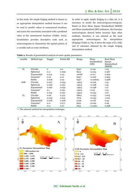
(Krig<str<strong>on</strong>g>in</str<strong>on</strong>g>g) (Table 2). Fig. 8 shows <str<strong>on</strong>g>the</str<strong>on</strong>g> maps <str<strong>on</strong>g>of</str<strong>on</strong>g> Ec, SAR,<br />
<strong>and</strong> Cl estimates obta<str<strong>on</strong>g>in</str<strong>on</strong>g>ed by <str<strong>on</strong>g>the</str<strong>on</strong>g> simple Krig<str<strong>on</strong>g>in</str<strong>on</strong>g>g<br />
<str<strong>on</strong>g>in</str<strong>on</strong>g>terpolati<strong>on</strong> method.<br />
Table 2. Results <str<strong>on</strong>g>of</str<strong>on</strong>g> geostatistical <strong>analysis</strong> <str<strong>on</strong>g>of</str<strong>on</strong>g> water quality parameters.<br />
variable Method type Nugget Partial Sill Range Mean<br />
st<strong>and</strong>ardized<br />
(MS)<br />
Ec Circular 0 0.2 6597 -0.041 1.03<br />
Spherical 0.11 0.099 8312 -0.024 0.967<br />
Exp<strong>on</strong>ential 0.014 0.23 10066 -0.011 0.969<br />
Gaussian* 0.02 0.21 6597 -0.026 0.963<br />
Stable 0.006 0.22 6597 -0.02609 0.968<br />
SAR Circular 0.097 0.053 14915 -0.036 1.23<br />
Spherical 0.096 0.051 14915 -0.038 1.25<br />
Exp<strong>on</strong>ential 0.092 0.052 14915 -0.048 1.27<br />
Gaussian* 0.1 0.051 14915 -0.03 1.22<br />
Stable 0.103 0.051 14915 -0.033 1.22<br />
CL Circular 0.06 0.312 6864 -0.033 1.003<br />
Spherical 0.059 0.319 7679 -0.033 1.003<br />
Exp<strong>on</strong>ential 0.006 0.406 9739 -0.016 0.95<br />
Gaussian* 0.11 0.271 6641 -0.029 0.99<br />
Stable 0.11 0.27 6641 -0.0291 0.998<br />
*= The selected method for <str<strong>on</strong>g>in</str<strong>on</strong>g>terpolati<strong>on</strong> technique.<br />
Root Mean<br />
Square<br />
St<strong>and</strong>ardized<br />
(RMSS)<br />
342 | Soleimani Sardo et al.

![Review on: impact of seed rates and method of sowing on yield and yield related traits of Teff [Eragrostis teff (Zucc.) Trotter] | IJAAR @yumpu](https://documents.yumpu.com/000/066/025/853/c0a2f1eefa2ed71422e741fbc2b37a5fd6200cb1/6b7767675149533469736965546e4c6a4e57325054773d3d/4f6e6531383245617a537a49397878747846574858513d3d.jpg?AWSAccessKeyId=AKIAICNEWSPSEKTJ5M3Q&Expires=1717110000&Signature=zfmmoBfgvhnWETYSUh9xDAkRMbg%3D)


