
Create successful ePaper yourself
Turn your PDF publications into a flip-book with our unique Google optimized e-Paper software.
CHAPTER 11<br />
NAME: _____________________________________________<br />
GEORGIA EXPERIENCE | GRADE 5 | UNIT 5<br />
PRIMARY SOURCE ANALYSIS<br />
TEACHER NOTES<br />
Primary Source Analysis<br />
Before World War II, Japan ruled the Korean peninsula as<br />
its colony. When Japan lost the war, the Allies made Japan<br />
give up its colony. But the Allies had to decide what to do<br />
with the Korean Peninsula. The U.S. and the Soviet Union<br />
agreed to divide the peninsula along the 38th parallel of<br />
latitude. The Soviets occupied the northern half, and the<br />
U.S. occupied the southern half.<br />
In the Korean War, the north and south regions fought<br />
over control of the whole peninsula. After three years, they agreed<br />
to stop fighting. The ceasefire left the dividing line very close to where it had started, and even<br />
though it does not run exactly along the 38th parallel, it crosses it.<br />
To avoid constant fighting along the border, two kilometers on each side of the line that<br />
separates North Korea and South Korea were designated as a demilitarized zone (DMZ).<br />
This area is considered neutral, and it is off-limits to most people.<br />
The areas north and south of the DMZ are heavily fortified. But inside this four-kilometer strip<br />
that stretches across the peninsula, nature has taken over! The DMZ is one of the most natural,<br />
undeveloped areas in Asia. Thousands of birds, fish, and mammals, many endangered, live here.<br />
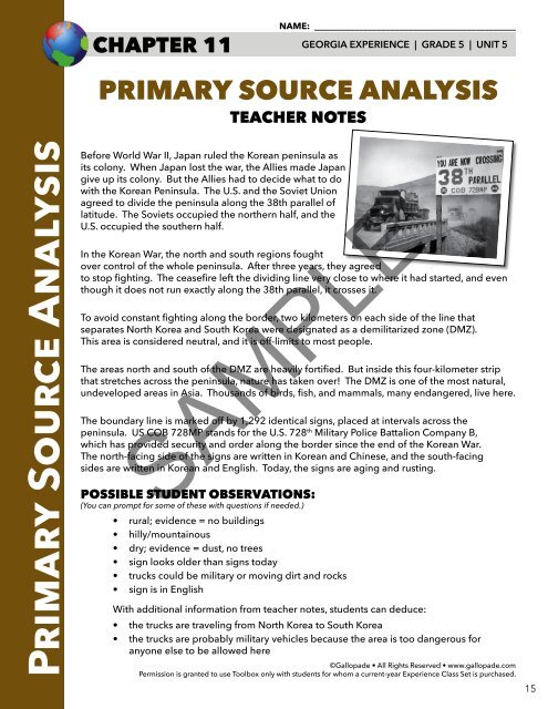
The boundary line is marked off by 1,292 identical signs, placed at intervals across the<br />
peninsula. US COB 728MP stands for the U.S. 728 th Military Police Battalion Company B,<br />
which has provided security and order along the border since the end of the Korean War.<br />
The north-facing side of the signs are written in Korean and Chinese, and the south-facing<br />
sides are written in Korean and English. Today, the signs are aging and rusting.<br />
SAMPLE<br />
POSSIBLE STUDENT OBSERVATIONS:<br />
(You can prompt for some of these with questions if needed.)<br />
• rural; evidence = no buildings<br />
• hilly/mountainous<br />
• dry; evidence = dust, no trees<br />
• sign looks older than signs today<br />
• trucks could be military or moving dirt and rocks<br />
• sign is in English<br />
With additional information from teacher notes, students can deduce:<br />
• the trucks are traveling from North Korea to South Korea<br />
• the trucks are probably military vehicles because the area is too dangerous for<br />
anyone else to be allowed here<br />
©Gallopade • All Rights Reserved • www.gallopade.com<br />
Permission is granted to use <strong>Toolbox</strong> only with students for whom a current-year Experience Class Set is purchased.<br />
15