Weber River Flood Damage Assessment - Riverdale City
Weber River Flood Damage Assessment - Riverdale City
Weber River Flood Damage Assessment - Riverdale City

You also want an ePaper? Increase the reach of your titles
YUMPU automatically turns print PDFs into web optimized ePapers that Google loves.
<strong>River</strong>dale <strong>City</strong> 2011 <strong>Flood</strong> <strong>Damage</strong> <strong>Assessment</strong><br />
October 13, 2011<br />
Prepared By:<br />
POB 2123<br />
Glenwood Springs, CO 81602<br />
Prepared For:<br />
<strong>River</strong>dale <strong>City</strong>, Utah<br />
Public Works department<br />
4600 South <strong>Weber</strong> <strong>River</strong> Drive<br />
<strong>River</strong>dale <strong>City</strong>, Utah 84405
<strong>River</strong>dale <strong>City</strong> 2011 <strong>Flood</strong> <strong>Assessment</strong> October 13, 2011<br />
<strong>River</strong>dale <strong>City</strong> 2011 <strong>Flood</strong> <strong>Assessment</strong><br />
October 13, 2011<br />
Table of Contents<br />
Introduction..............................................................................................................................................................1<br />
<strong>Weber</strong> <strong>River</strong> Geomorphology and Ecology ..............................................................................................................2<br />
<strong>Weber</strong> <strong>River</strong> <strong>Flood</strong> <strong>Damage</strong> <strong>Assessment</strong>............................................................................................................... 10<br />
<strong>Flood</strong> Mitigation Opportunities............................................................................................................................. 15<br />
Ecosystem Enhancement Opportunities ............................................................................................................... 18<br />
Recreational Enhancement Opportunities............................................................................................................ 24<br />
Summary................................................................................................................................................................ 27<br />
APPENDIX A‐<strong>Flood</strong> <strong>Damage</strong> <strong>Assessment</strong>s ............................................................................................................. 28<br />
#1‐<strong>Weber</strong> <strong>River</strong> Parkway Collapse ................................................................................................................ 28<br />
#2‐Bank Collapse Across From <strong>River</strong>dale Mobile Estates ............................................................................. 36<br />
#3‐Frisbee Golf Course Riprap Failure........................................................................................................... 39<br />
#4‐<strong>River</strong>dale Play Park, Grade control and Riprap Failure ............................................................................ 44<br />
#5‐54” RCP outfall @ W4400S & S <strong>Weber</strong> <strong>River</strong> Dr. ..................................................................................... 54<br />
#6 #14‐Two 36” RCP outfalls and Rip‐rap @ <strong>River</strong>dale Rd. Bridge ............................................................... 57<br />
#7‐Concrete Revetment at Les Schwab Tire.................................................................................................. 61<br />
#8‐Riprap at 4600S and <strong>Weber</strong> <strong>River</strong> Dr. Bridge ........................................................................................... 65<br />
#9 & #14‐Creekside Trailhead Path Erosion @ <strong>River</strong> Glen Subdivision......................................................... 67<br />
#10‐Failed Bank Stabilization ........................................................................................................................ 77<br />
#11‐Failed Bank Stabilization ........................................................................................................................ 81<br />
#12‐Failed Bank Stabilization ........................................................................................................................ 87
<strong>River</strong>dale <strong>City</strong> 2011 <strong>Flood</strong> <strong>Assessment</strong> October 13, 2011<br />
Table of Figures<br />
Figure 1-Example of large alluvial deposits upstream of <strong>River</strong>dale <strong>City</strong>. ................................................ 3<br />
Figure 2-Active channel upstream of <strong>River</strong>dale <strong>City</strong> ............................................................................... 3<br />
Figure 3-1953 Aerial photo shows channel meander pattern of <strong>Weber</strong> <strong>River</strong> through <strong>River</strong>dale <strong>City</strong>..... 5<br />
Figure 4-2009 Aerial photo shows current meander pattern of <strong>Weber</strong> <strong>River</strong> through <strong>River</strong>dale <strong>City</strong>...... 7<br />
Figure 5-<strong>Weber</strong> <strong>River</strong> Annual Average Discharge.................................................................................... 8<br />
Figure 6-Overgrown Riparian Vegetation................................................................................................. 8<br />
Figure 7-Fine sediment deposition resulting from decreased overbank velocities................................... 9<br />
Figure 8-Historic Peak Discharge [cfs]................................................................................................... 10<br />
Figure 9-<strong>Flood</strong> <strong>Damage</strong> Sites ................................................................................................................. 13<br />
Figure 10-<strong>Flood</strong> Mitigation Concept Plan .............................................................................................. 17<br />
Figure 11-Ecosystem Enhancement Opportunities................................................................................. 19<br />
Figure 12-North Trailhead Wetland ........................................................................................................ 20<br />
Figure 13-Oxbow wetland ...................................................................................................................... 21<br />
Figure 14-Brine Shrimp Wetland concrete fill........................................................................................ 22<br />
Figure 15-Recreational Enhancements ................................................................................................... 26
<strong>River</strong>dale <strong>City</strong> 2011 <strong>Flood</strong> <strong>Assessment</strong> October 13, 2011<br />
Introduction<br />
Water year 2011 was marked by a significant snowpack in Northern Utah and a wet spring that<br />
detained runoff well past the typical peak flow periods of mid May. As a result a significant flood event<br />
occurred on the <strong>Weber</strong> <strong>River</strong> within <strong>River</strong>dale <strong>City</strong>, UT in April, May and June of 2011. Stream flows<br />
of 4,640 cfs, on April 18 th , and 4,610 cfs, on June 10, were measured at the USGS gage station located<br />
at Gateway, UT (USGS 10136500). Average daily flows were sustained above the 10-year recurrence<br />
interval for a total of 27 days. This year’s stream flows on the <strong>Weber</strong> <strong>River</strong> almost reached the 50-year<br />
recurrence interval event of 5,300 cfs (100-year event is 7,000 cfs, FIS, FEMA, 2005). Flows were on<br />
the order of a 25 year event which has a 4% chance of occurrence in any given year. USGS gage<br />
records indicate that this flow has been exceeded 15 times since 1890.<br />
While communities throughout Utah experienced significant flooding <strong>River</strong>dale <strong>City</strong> was hit<br />
particularly hard. <strong>River</strong>dale <strong>City</strong>’s emergency response efforts combined with citizen volunteers<br />
minimized the flood extent. However, significant damage was sustained by property and public<br />
infrastructure. Furthermore, the duration and magnitude of flows this season caused channel<br />
instabilities in several areas that may continue to threaten infrastructure, result in loss of land, flood<br />
property, destabilize banks, devalue recreational resources, and reduce the stability of the channel with<br />
future flood events. The extent of 2011 flood damage has caused <strong>River</strong>dale <strong>City</strong> to declare a State of<br />
Emergency on June 20 th , 2011. <strong>Flood</strong>ing was severe enough that President Obama declared a Major<br />
Disaster for the State of Utah making federal disaster aid available to communities impacted by the<br />
disaster.<br />
The <strong>Weber</strong> <strong>River</strong> in <strong>River</strong>dale <strong>City</strong> is located in a dynamic alluvial system that once migrated across a<br />
broad floodplain as it made its way to the Great Salt Lake. The <strong>Weber</strong> <strong>River</strong> has a highly mobile<br />
riverbed whose configuration can change dramatically from one high flow event to the next.<br />
Development along the river corridor has confined the channel in many locations, constraining the<br />
river’s pre-development tendency to shift its channel over a broad floodplain. The <strong>Weber</strong> <strong>River</strong><br />
conveys heavy bedload, has steep bank slopes and is comprised of poorly consolidated soils. In many<br />
areas there is insufficient vegetation to support the banks while in other areas the riparian vegetation is<br />
extremely dense, encroaches on the river, and limits the ability of the over bank areas to convey flood<br />
flows. The combination of development, flooding and channel instabilities has adversely impacted<br />
infrastructure, degraded habitat, limited flood attenuation and altered flood flow conveyance.<br />
This report presents the results of a flood damage assessment performed during August, 2011.<br />
<strong>River</strong>Restoration performed a reconnaissance survey of a 3.15 mile reach of the <strong>Weber</strong> <strong>River</strong> within<br />
<strong>River</strong>dale <strong>City</strong>. The <strong>River</strong> was assessed for damage to public infrastructure resulting from the 2011<br />
flooding. Recommendations for damage repair were developed for each of the identified locations. The<br />
flood damage information was used to develop recommendations for possible flood mitigation<br />
approaches intended to reduce the impact of future events. Additionally, opportunities to improve<br />
riverine and riparian ecosystem functions were identified as well as a number of opportunities for<br />
recreational enhancements.<br />
<strong>Flood</strong> events are a rare occurrence. The river is dynamic system with multiple functions.<br />
<strong>River</strong>Restoration took a systemic approach to make recommendations for flood control, bank<br />
stabilization, and riparian ecological health balanced with development and recreation within the river<br />
corridor.<br />
1
<strong>River</strong>dale <strong>City</strong> 2011 <strong>Flood</strong> <strong>Assessment</strong> October 13, 2011<br />
<strong>Weber</strong> <strong>River</strong> Geomorphology and Ecology<br />
Gilbert White, the preeminent American geographer, once said, “<strong>Flood</strong>s are acts of God, but flood<br />
losses are largely acts of man.” This quote points to the fact that it is important to have a thorough<br />
understanding of the <strong>Weber</strong> <strong>River</strong>’s human history as well as geologic and ecologic history in order to<br />
identify the underlying causes of the flood damage incurred during the 2011 runoff season.<br />
Upstream of <strong>River</strong>dale <strong>City</strong> the <strong>Weber</strong> <strong>River</strong> drains an area of approximately 1640 square miles. The<br />
<strong>Weber</strong> <strong>River</strong> rises in the Uinta Mountains at the foot of Reids Mountain in the Unita-Wasatch-Cache<br />
National Forest, approximately 65 miles to the southeast of <strong>River</strong>dale <strong>City</strong>. The <strong>River</strong> flows<br />
approximately 125 miles north and west cutting through the Wasatch Mountains just to the east of<br />
<strong>River</strong>dale <strong>City</strong> and eventually discharging into the Great Salt Lake. During the Pleistocene epoch much<br />
of the area between the Wasatch Front and what is now the Great Salt Lake was covered by Lake<br />
Bonneville. As the <strong>Weber</strong> <strong>River</strong> discharged into Lake Bonneville it formed a large delta. Evidence<br />
indicates that Lake Bonneville may have advanced and receded a number of times over the past three<br />
million years. Approximately 14,500 year ago a large portion of Lake Bonneville drained through the<br />
Red Rocks Pass in Idaho in what is referred to as the Bonneville <strong>Flood</strong>. Subsequently the lake level has<br />
continued to rise and fall a number of times to reach its present level. The shore lines of some of these<br />
historic lake levels are evident along the Wasatch Front. At each level the <strong>Weber</strong> <strong>River</strong> formed a new<br />
delta where it entered the lake. <strong>River</strong>dale <strong>City</strong> is located in a valley that the <strong>Weber</strong> <strong>River</strong> has formed by<br />
cutting through these old delta and lakeshore deposits.<br />
The <strong>Weber</strong> <strong>River</strong> Valley where <strong>River</strong>dale <strong>City</strong> lies ranges from less than 3000 ft wide to over 6000 ft<br />
wide. Prior to human development the river was free to move across this entire valley in a dynamic<br />
process of aggradation and degradation. As the river deposits alluvium in one location, the bed<br />
aggrades, and the river is forced to flow in another direction. This result of this process is an ever<br />
changing meandering plan form and multiple channels. This action is most evident upstream of<br />
<strong>River</strong>dale <strong>City</strong> where large alluvial deposits and active bank erosion are particularly evident (Figure 1<br />
and Figure 2). The reach upstream of <strong>River</strong>dale <strong>City</strong> is owned by the Utah Department of Natural<br />
Resources and has seen little urbanization when compared to <strong>River</strong>dale <strong>City</strong>. The river upstream has<br />
many cobble bars and changes its channel course every year.<br />
2
<strong>River</strong>dale <strong>City</strong> 2011 <strong>Flood</strong> <strong>Assessment</strong> October 13, 2011<br />
Figure 1-Example of large alluvial deposits upstream of <strong>River</strong>dale <strong>City</strong>.<br />
Figure 2-Active channel upstream of <strong>River</strong>dale <strong>City</strong><br />
As the valley was urbanized over the last 100 years the river’s ability to meander through <strong>River</strong>dale<br />
<strong>City</strong> has been significantly reduced by urbanization. Aerial photographs from 1953, 1954, 1971, 1973,<br />
1979, 1980, 1997, 2003, 2006, and 2009 were reviewed to understand the geomorphic evolution of the<br />
reach through <strong>River</strong>dale <strong>City</strong>. In the photos from the 1953 and 1954 it is apparent that <strong>River</strong>dale <strong>City</strong><br />
3
<strong>River</strong>dale <strong>City</strong> 2011 <strong>Flood</strong> <strong>Assessment</strong> October 13, 2011<br />
was largely an agricultural community with farmlands dominating the landscape (Figure 1). While the<br />
river was somewhat constrained by the railroad and Highway it was free to migrate across much of the<br />
valley. Historic flow paths are evident throughout the 1953 photo. Historic channel alignments appear<br />
as dark oxbow shaped areas, which are older alignments that have become vegetated, or light oxbow<br />
shaped areas, which are more recent (see Figure 3). These historic channels indicate that the <strong>Weber</strong><br />
<strong>River</strong> may have had a meander belt width in excess of 1500ft. Analysis of Figure 3 indicates that the<br />
<strong>Weber</strong> <strong>River</strong> had a meander belt width over 1000 ft wide in 1953. In this active system as the main<br />
channel aggrades and a new main channel is formed the old channel is still available to convey water at<br />
high flows. These overflow channels relieve pressure within the main channel. Shear stress in the main<br />
channel is thus reduced resulting in less bank erosion than if all flood flow remained in the main<br />
channel. Loss of these overflow side channels results in increased pressure in the main channel causing<br />
excessive bank erosion and down cutting (degradation) of the channel bed.<br />
Although riparian areas represent less than one percent of the land within Utah, they are among the<br />
most diverse and densely used wildlife habitat in this region. Animals including migratory songbirds,<br />
deer, elk and amphibians rely on these riparian corridors for food, cover, breeding habitat and<br />
movement corridors. Riparian areas also provide many important functions to humans, from recreation<br />
to providing clean and abundant water, to reducing flooding. Disturbance of a riparian area also has a<br />
cause and effect that changes the characteristic of these environments. The aggradation of historic flow<br />
paths and the resultant migration of the river to new flow paths create a mosaic of diverse habitat.<br />
Some remnant channels remain open, filling with water and becoming oxbow lakes or wetlands. Newly<br />
exposed point bars provide new habitat for riparian plants. Diversity is one of the most important<br />
measures of habitat quality.<br />
Riparian forest species such as Fremont Cottonwoods (Populus fremontii) have evolved with channel<br />
migration as a critical component of their life cycle. High flows during spring runoff mobilize<br />
sediments at the edge of active channels and create point bars. Additionally overbank flows may scour<br />
areas of vegetative cover and mulch. These exposed areas are essential for cottonwood establishment.<br />
The cottonwood seeds are deposited in these areas which remain wet as the river recedes. The seeds<br />
germinate at this time and grow a tap root that follows the water table as the hydrograph declines,<br />
creating new riparian forests. These forests in turn capture sediment and retain floods. Many other plant<br />
and animal species are similarly adapted to this dynamic environment.<br />
4
<strong>River</strong>dale <strong>City</strong> 2011 <strong>Flood</strong> <strong>Assessment</strong> October 13, 2011<br />
Figure 3-1953 Aerial photo shows channel meander pattern of <strong>Weber</strong> <strong>River</strong> through <strong>River</strong>dale <strong>City</strong>.<br />
5
<strong>River</strong>dale <strong>City</strong> 2011 <strong>Flood</strong> <strong>Assessment</strong> October 13, 2011<br />
Over the last 58 years <strong>River</strong>dale <strong>City</strong> has become significantly urbanized. Figure 4 shows the 2009<br />
aerial photo and the current meander pattern of the <strong>Weber</strong> <strong>River</strong>. The 1953 meander pattern is also<br />
shown for reference. As the community has developed the river has been straightened and encroached.<br />
The length of the <strong>River</strong>dale <strong>City</strong> reach has been reduced by approximately 20%. Historically the river<br />
had a meander belt width in excess of 1500 ft. In places this width has been reduced to less than 150 ft.<br />
The sinuosity of the reach has been reduced from more than 1.38 to less than 1.14. This also means that<br />
the river has been steepened by 20%. This has increased channel degradation. This encroachment has<br />
significantly altered the form and function of the <strong>Weber</strong> <strong>River</strong> through <strong>River</strong>dale <strong>City</strong>.<br />
The encroachment of the river has significantly reduced the quantity and quality of riparian habitat. The<br />
main channel of the <strong>Weber</strong> <strong>River</strong> has been significantly narrowed and deepened and the channel slope<br />
has increased. There is a decreased connection between the main channel and the floodplain. Side<br />
channels that were once available to convey flood flows have either been completely destroyed or they<br />
have become isolated from the main channel. These hydromodifications have increased the shear stress<br />
on the bottom and banks of the streams. This process has pushed the stream across a threshold; the<br />
stream no longer functions like the upstream and downstream reaches; aggrading the channel, eroding<br />
banks and forming new channels, floodplains, and point bars. Now this reach of the river has a much<br />
greater sediment transport capacity than the upstream reach. There is very little evidence of mid<br />
channel and point bar deposits throughout the <strong>River</strong>dale <strong>City</strong> reach. As the river responds to these<br />
changes, significant portions of the river bank have been hardened with concrete refuse such as old<br />
sidewalks, curb and gutter, etc. <strong>River</strong> impoundments upstream have also altered the natural hydrograph<br />
of the river, which makes the river function differently.<br />
Environmental factors have added to the human alteration of the <strong>Weber</strong> <strong>River</strong>. Specifically, the severe<br />
drought of the early 2000s limited overbank disturbance (Figure 5). While the most severe drought<br />
period was early 2001 through mid 2005 the extended drought period for Utah lasted until 2010. The<br />
lack of flood flows and disconnect between the main channel and overbank areas has allowed<br />
vegetation to encroach the channel (Figure 6). What few flood flow channels that were connected to the<br />
river have become overgrown. In portions of the riparian corridor the forest understory has become so<br />
overgrown that it is difficult to walk through (from humans and wildlife). This thick growth has<br />
limited the flood conveyance capacity of these flood relief channels as well as exacerbated wildfire<br />
risk. The decreased velocities in the connected over bank areas has also increased the deposition of fine<br />
sediment. This is evidenced by Figure 7, which shows an old barb wire fence and t-post. This fence was<br />
likely used by ranchers or farmers prior to the urbanization of <strong>River</strong>dale. This side channel appears to<br />
have aggraded by over three feet since the post was set.<br />
6
<strong>River</strong>dale <strong>City</strong> 2011 <strong>Flood</strong> <strong>Assessment</strong> October 13, 2011<br />
Figure 4-2009 Aerial photo shows current meander pattern of <strong>Weber</strong> <strong>River</strong> through <strong>River</strong>dale <strong>City</strong>.<br />
7
<strong>River</strong>dale <strong>City</strong> 2011 <strong>Flood</strong> <strong>Assessment</strong> October 13, 2011<br />
Discharge [cfs]<br />
1600<br />
1400<br />
1200<br />
1000<br />
800<br />
600<br />
400<br />
200<br />
0<br />
1921<br />
1924<br />
1927<br />
1930<br />
1933<br />
1936<br />
1939<br />
1942<br />
<strong>Weber</strong> <strong>River</strong> Annual Average Dicharge<br />
1945<br />
1948<br />
1951<br />
1954<br />
1957<br />
1960<br />
1963<br />
1966<br />
1969<br />
Year<br />
1972<br />
1975<br />
1978<br />
1981<br />
1984<br />
1987<br />
1990<br />
1993<br />
1996<br />
1999<br />
2002<br />
2005<br />
Figure 5-<strong>Weber</strong> <strong>River</strong> Annual Average Discharge<br />
Figure 6-Overgrown Riparian Vegetation.<br />
8<br />
2008<br />
Annual Discharge<br />
Historic Average
<strong>River</strong>dale <strong>City</strong> 2011 <strong>Flood</strong> <strong>Assessment</strong> October 13, 2011<br />
Figure 7-Fine sediment deposition resulting from decreased overbank velocities.<br />
9
<strong>River</strong>dale <strong>City</strong> 2011 <strong>Flood</strong> <strong>Assessment</strong> October 13, 2011<br />
<strong>Weber</strong> <strong>River</strong> <strong>Flood</strong> <strong>Damage</strong> <strong>Assessment</strong><br />
The human and environmental factors outlined above combined with a record setting snowpack to<br />
cause the severe flooding experienced during the 2011 runoff. Fortunately, the cool, wet weather of last<br />
spring reduced the intensity of runoff and prevented even more severe flooding in <strong>River</strong>dale <strong>City</strong>.<br />
<strong>River</strong>dale <strong>City</strong> residents are not unfamiliar with these types of flooding events; the historic record<br />
indicates that there have been 15 years where peak discharges have been larger than 2011 (Figure 8)<br />
and certainly many residents remember the devastating flood caused by the breach of the <strong>Weber</strong>-Davis<br />
Canal in 1999. The <strong>Weber</strong> <strong>River</strong> Project (USBR) including Rockport and Echo reservoirs has provided<br />
an accumulated $12M in flood control benefits from 1950-1999.<br />
Figure 8-Historic Peak Discharge [cfs]<br />
During our assessment, <strong>River</strong>Restoration identified 14 locations where public infrastructure was<br />
damaged during the 2011 flood event. Table 1 presents the damaged sites and the locations of the<br />
damaged areas are indicated in Figure 9. Individual site assessments are presented in Appendix A.<br />
These assessments described the damage incurred and identify any contributing factors as outlined in<br />
the previous section. The site assessments also identify the actions necessary to repair the damaged<br />
sites to their pre-flood conditions. Where alternative approaches to individual site reparations are<br />
feasible those alternatives are identified. Order of magnitude costs are included in the site assessments.<br />
10
<strong>River</strong>dale <strong>City</strong> 2011 <strong>Flood</strong> <strong>Assessment</strong> October 13, 2011<br />
Table 1-<strong>Flood</strong> <strong>Damage</strong> <strong>Assessment</strong> Sites<br />
Site # Site Name<br />
1 <strong>Weber</strong> <strong>River</strong> Parkway Collapse<br />
2 Across From <strong>River</strong>dale Mobile Estates<br />
3 Frisbee Golf Course Riprap Failure<br />
4 <strong>River</strong>dale Play Park and Riprap Failure<br />
5 54" RCP outfall @ W4400S & S <strong>Weber</strong> <strong>River</strong> Dr.<br />
6 Two 36" RCP outfalls Downstream of <strong>River</strong>dale Road<br />
7 Concrete Revetment at Les Schwab Tire<br />
8 Riprap at 4600S and <strong>Weber</strong> <strong>River</strong> Dr. Bridge<br />
9 Creekside Trailhead Path Erosion @ <strong>River</strong> Glen Subdivision<br />
10 Failed J‐Hooks<br />
11 Failed J‐Hooks and Riprap<br />
12 Failed J‐Hooks<br />
13 <strong>Weber</strong> <strong>River</strong>trail Bank Erosion Upstream of <strong>River</strong> Glen Subdivision<br />
14 Failed Riprap at <strong>River</strong>dale Rd. Bridge<br />
11
<strong>River</strong>dale <strong>City</strong> 2011 <strong>Flood</strong> <strong>Assessment</strong> October 13, 2011<br />
12
<strong>River</strong>dale <strong>City</strong> 2011 <strong>Flood</strong> <strong>Assessment</strong> October 13, 2011<br />
Figure 9-<strong>Flood</strong> <strong>Damage</strong> Sites<br />
13
<strong>River</strong>dale <strong>City</strong> 2011 <strong>Flood</strong> <strong>Assessment</strong> October 13, 2011<br />
As indicated in the previous section and outlined in the individual assessments, repairing these<br />
damaged sites to their pre-flood conditions may result in similar future flooding and associated<br />
damages. While the Individual Site <strong>Assessment</strong> Sheets contain recommendations for reparations and<br />
associated opinions of the magnitude of cost for these reparations, <strong>River</strong>Restoration urges the<br />
community to consider addressing these issues on a more systemic basis. The following section, <strong>Flood</strong><br />
Mitigation Opportunities, identifies alternative approaches to addressing these issues that may lessen<br />
the impact of future flooding, while benefiting the <strong>Weber</strong> <strong>River</strong> as a whole.<br />
14
<strong>River</strong>dale <strong>City</strong> 2011 <strong>Flood</strong> <strong>Assessment</strong> October 13, 2011<br />
<strong>Flood</strong> Mitigation Opportunities<br />
While the flood of 2011 was the direct cause of these damages, there are systemic problems with this<br />
reach of the <strong>Weber</strong> <strong>River</strong>. <strong>River</strong>Restoration believes that addressing these issues on a system wide basis<br />
has a number of benefits. Some of the damaged areas, like the rip-rap around a sewer outfall, are easily<br />
repaired back to their pre-flood conditions and the systemic implications are insignificant. In contrast,<br />
repairing some of the damaged sites to their pre-flood conditions may inevitably lead to future<br />
damages, maintenance, human risk and expense for the community. Particular examples of this are the<br />
numerous j-hooks that were placed in the river to reduce bank erosion. As indicated in the individual<br />
site assessments, many of these J-hooks were installed without a systemic approach and may have<br />
caused bank instabilities elsewhere. Additionally, their application in the <strong>Weber</strong> <strong>River</strong> is questionable.<br />
Approaching the flooding issues on the <strong>Weber</strong> <strong>River</strong> with a system wide approach may have added<br />
benefits to the community and the river ecosystem. It is <strong>River</strong>Restoration’s experience that this<br />
approach has the added benefit of bringing a wide range of collaborating partners to the table, creating<br />
greater opportunities for project funding and success. Entities that may be supportive of this approach<br />
include, but are not limited to, the Utah DNR, USFWS, USFS, NRCS, FEMA, USACE, <strong>Weber</strong> County<br />
Parks and Recreation, Utah State Parks, Central <strong>Weber</strong> County Sewer Improvement District, DEQ,<br />
EPA, Irrigation Ditch Companies, USGS, <strong>Weber</strong> Basin Water and Conservation District, Trout<br />
Unlimited, and private donors. <strong>River</strong>Restoration has identified a number of synergistic approaches to<br />
addressing the critical issues on the <strong>Weber</strong> <strong>River</strong> within <strong>River</strong>dale <strong>City</strong> and beyond. The following<br />
paragraphs describe these general approaches. Figure 10 presents one possible system wide concept<br />
plan for addressing these complex issues.<br />
Let the river have room to do what it needs to do. Where the bike path has been damaged do not<br />
reconstruct it in the same alignment. While land acquisition and easements may seem burdensome, the<br />
benefit of providing adequate room for the river to function may result in long term cost benefit<br />
advantages due to decrease closures, maintenance and repairs.<br />
Provide overflow channels where possible. Backwater areas may help attenuate the peak flows of<br />
flashy floods like those caused by a thunderstorm, but they do not help with a flood that has a peak<br />
duration like the one <strong>River</strong>dale <strong>City</strong> experienced this past spring. These back water areas may inundate<br />
early in the sustained flood event and once they are inundated the main channel of the river is left to<br />
convey the remainder of the flood event. Sustained floods are addressed by providing conveyance. As<br />
previously indicated the <strong>Weber</strong> <strong>River</strong> has lost much of its overbank conveyance. Urban development<br />
has encroached on the river eliminating many of the overbank conveyance areas that would naturally<br />
be available to relieve pressure on the main channel. Where these overbank conveyance areas have not<br />
been eliminated they have become overgrown and silted in, reducing their capacity to provide sufficient<br />
conveyance. Recreating these channels were possible may improve the overall conveyance of the river<br />
and reduce associated flood impacts. Where these channels exist they should be cleared of overgrowth<br />
to increase conveyance during the high flow events. This may also provide needed wildfire mitigation.<br />
This could be done any number of way including mechanical removal, hand removal, or prescribed<br />
burns.<br />
Provide offset levees. There are currently a number of levees throughout <strong>River</strong>dale <strong>City</strong> that provide<br />
intermittent protection. Many of them are discontinuous, providing opportunity for flood flows to either<br />
flow or backwater around and providing little protection for <strong>River</strong>dale <strong>City</strong> residents. Additionally,<br />
15
<strong>River</strong>dale <strong>City</strong> 2011 <strong>Flood</strong> <strong>Assessment</strong> October 13, 2011<br />
many of these levees are located too close to the river, eliminating the connection of the floodplain to<br />
the river. A preferable approach would be to remove these levees, allowing the river to reconnect to the<br />
floodplain. In their place offset levees should be constructed at the limits of the floodplain, along<br />
adjacent property lines, to provide protection for the adjacent residential and commercial properties.<br />
This approach may provide needed overbank conveyance, improve riparian habitat, and eliminate the<br />
nearly annual practice of placing sandbags to protect the community.<br />
Where feasible lay back banks. This may improve conveyance of the main channel while reducing<br />
bank shear stress. This should be done with caution. As previously indicated the <strong>River</strong>dale <strong>City</strong> reach<br />
of the <strong>Weber</strong> <strong>River</strong> has been so constrained that it no longer functions as it did in its natural state. The<br />
river has crossed a transport threshold creating a situation much like placing a collar on tiger. The reach<br />
upstream of <strong>River</strong>dale <strong>City</strong> displays the dynamic behavior of aggradation, point and mid channel bar<br />
formation and the subsequent formation of a new channel. It appears that all of the alluvial material<br />
supplied by the upstream reach is conveyed through <strong>River</strong>dale <strong>City</strong>. There is evidence of aggradation<br />
downstream (Fort Buenaventura Park, Parked Rd. Photo) but almost no evidence of aggradation within<br />
<strong>River</strong>dale <strong>City</strong>. In a sense the <strong>Weber</strong> <strong>River</strong> has become a contained beast within <strong>River</strong>dale <strong>City</strong> and<br />
care should be taken that this beast is not unleashed. Significant aggradation within <strong>River</strong>dale <strong>City</strong><br />
could have detrimental impacts (i.e. Fort BV). The sediment transport of this system, from canyon<br />
mouth downstream to Ogden, needs to be maintained.<br />
We recommend that the <strong>City</strong> revisit the 2005 FIS to ensure that it is still applicable. The FEMA<br />
mapping indicates that the open area between the <strong>River</strong> Bend Subdivision and the <strong>Weber</strong> <strong>River</strong><br />
(Creekside Trailhead) is located in Zone AE (the 100-year flood). As previously indicated, the flood<br />
event of 2011 was on the order of a 15 to 25 year event yet this area was inundated. The FEMA profile<br />
shows that the elevation of the 100-year flood is approximately 2.5 ft higher than the 10 year event.<br />
The Creekside Trailhead and adjacent homes experienced flooding during this event. This flooding may<br />
be the result of an overwhelmed stormwater system and an unusually high groundwater table<br />
combining with the <strong>Weber</strong> <strong>River</strong> <strong>Flood</strong>ing. A 1.5 to 2.5 ft increase in water surface elevation could<br />
significantly impact these residential areas. High groundwater and an overwhelmed stormwater system<br />
would worsen the impact of a 100-Year event. This issue may be address by constructing a stormwater<br />
pump system that increases the conveyance of the existing stormwater infrastructure. However a pump<br />
system may not be effective if it is not incorporated into an associated offset levee to prevent the<br />
recirculation of the pumped stormwater.<br />
16
<strong>River</strong>dale <strong>City</strong> 2011 <strong>Flood</strong> <strong>Assessment</strong> October 13, 2011<br />
Figure 10-<strong>Flood</strong> Mitigation Concept Plan<br />
17
<strong>River</strong>dale <strong>City</strong> 2011 <strong>Flood</strong> <strong>Assessment</strong> October 13, 2011<br />
Ecosystem Enhancement Opportunities<br />
Many of the recommendations presented in the previous section may have direct positive impacts on<br />
the <strong>Weber</strong> <strong>River</strong>’s riparian and in-channel habitats. It is <strong>River</strong>Restoration underling philosophy that a<br />
healthy river provides a multitude of services. A healthy river provides a verity of in channel habitat to<br />
support a diverse assembly of aquatic species. It interacts with the floodplain to maintain robust and<br />
resilient riparian habitat for the wide range of species that depend on this critical ecosystem. It conveys<br />
flood flows and sediment while protecting and preserving the adjacent human uses. It provides<br />
adequate water quality and quantity for human uses (irrigation, domestic water supply, etc.). And lastly<br />
a healthy river supports the economy of the adjacent communities by providing recreational<br />
opportunities for locals and visitors alike (fishing, boating, passive recreation, etc.).<br />
Providing the river sufficient room to function naturally has many ancillary benefits. Providing an<br />
adequate buffer along the river allows riparian ecosystems to function naturally. The land preserved for<br />
the river may be used as open space, providing opportunities for recreational activities as well as<br />
providing conveyance and attenuation of floods. Reconnecting the river to the floodplain, where<br />
feasible, may also help restore the riparian ecosystem while providing the added benefit of flood<br />
mitigation. Opening up side channels may not only provide flood relief but also provide habitat<br />
diversity. Creating a dynamic and diverse riverine ecosystem may recreate the natural disturbance this<br />
system would experience in its undeveloped state, creating a mosaic of habitat. This may have the<br />
additional benefit of reducing wildfire risk by eliminating the contiguous stands of overgrown forest<br />
that currently have the potential for large scale catastrophic fires. Increasing in channel diversity by<br />
providing substrate diversity, mimicking natural pool and riffle sequencing, retaining some cobble<br />
material, and creating fishing holes can substantially improve the in channel habitat.<br />
In addition to the recommendations presented in the <strong>Flood</strong> Mitigation section there are additional<br />
ecosystem enhancement opportunities available throughout <strong>River</strong>dale <strong>City</strong>. There are a number of<br />
locations were the ecosystems are not fully functional. These areas can be placed into five general<br />
categories. The first four are wetlands, riparian forests, drop structures and in-stream habitat. The last<br />
category is stormwater returns. While stormwater returns are not natural ecosystems they have the<br />
potential to become excellent habitat as well as improve overall water quality. The following<br />
paragraphs address the general opportunities for each one of these categories. These specific locations<br />
of identified enhancement opportunities are presented Figure 11.<br />
18
<strong>River</strong>dale <strong>City</strong> 2011 <strong>Flood</strong> <strong>Assessment</strong> October 13, 2011<br />
Figure 11-Ecosystem Enhancement Opportunities<br />
19
<strong>River</strong>dale <strong>City</strong> 2011 <strong>Flood</strong> <strong>Assessment</strong> October 13, 2011<br />
Wetlands<br />
Adjacent to the <strong>Weber</strong> <strong>River</strong>, <strong>River</strong>Restoration identified three emergent wetlands. One wetland<br />
appears to be healthy and is located approximately 825 feet upstream of the Creekside Trail on the<br />
Parkway. This wetland has a robust diversity of species and appears to have adequate flow and<br />
oxygenation. The other two emergent wetlands have the potential to provide invaluable habitat and<br />
improve water quality but are in need of enhancement.<br />
The smallest and most downstream wetland is located adjacent to the North Trail Head. This wetland<br />
appears to be the associated with stormwater runoff from the adjacent area. This wetland drains under<br />
the <strong>Weber</strong> <strong>River</strong> Pathway just upstream of the Parker Rd. underpass. There is an abundance of algae<br />
and trash present in the wetland (Figure 12). This wetland may have insufficient flow to provide<br />
adequate oxygenation. The garbage should be removed and the mechanical drainage system should be<br />
inspected to ensure there is adequate flow through the wetland.<br />
Figure 12-North Trailhead Wetland<br />
The second emergent wetland is located approximately 550 ft upstream on the Parkway from the Great<br />
Salt Lake Brine Shrimp warehouse. This wetland appears to be a historic meander (or oxbow) that has<br />
been isolated from the river due to the trail construction (Figure 13). This wetland is completely<br />
covered with algae which reduces the amount of available oxygen. It is likely that this wetland is<br />
anoxic (lacking oxygen) below the surface. Additionally there is a substantial amount of concrete<br />
rubble dumped on the sides of the wetland. This concrete may have been placed there to protect the<br />
bank from erosion when this was an active channel. <strong>River</strong>Restoraion recommends reconnecting this<br />
wetland to the river with small culverts under the Parkway to improve its hydraulics as well as allow it<br />
to provide some level of backwater storage during flashy flood events. This wetland is unique within<br />
<strong>River</strong>dale <strong>City</strong> and has the potential to provide critical ecosystem functions as well as excellent<br />
educational (interpretive) opportunities. Removal of the concrete would also provide aesthetic benefits<br />
to the community.<br />
20
<strong>River</strong>dale <strong>City</strong> 2011 <strong>Flood</strong> <strong>Assessment</strong> October 13, 2011<br />
Figure 13-Oxbow wetland<br />
There is an additional non-emergent wetland adjacent to the Great Salt Lake Brine Shrimp warehouse.<br />
This wetland may be the result of backwater due to a tributary channel. There is a substantial amount of<br />
concrete rubble (Figure 14). The concrete may have been placed to protect the warehouse from<br />
flooding due to backwater. The concrete should be removed and potential flooding risk should be<br />
addressed with an offset levee as described in the previous section.<br />
21
<strong>River</strong>dale <strong>City</strong> 2011 <strong>Flood</strong> <strong>Assessment</strong> October 13, 2011<br />
Figure 14-Brine Shrimp Wetland concrete fill<br />
Riparian Areas<br />
In general riparian areas are overgrown due to lack of disturbance. There are areas were the forest is<br />
dominated by exotic species, particularly Russian Olive (Elaeagnus angustifolia L.). The understory is<br />
extremely overgrown. This overgrowth limits the habitat value of the riparian forest and creates a<br />
significant wildfire risk. As previously indicated, this thick growth has also limited the flood<br />
conveyance capacity of these flood relief channels as well as exacerbated wildfire risk. The decreased<br />
velocities in the connected over bank areas has also increased the deposition of fine sediment. There are<br />
numerous areas were the understory should be thinned and places where Class 4 pruning would benifict<br />
the forest canopy and reduce fire risk. This could be done any number of way including mechanical<br />
removal, hand removal, or prescribed burns.<br />
In-stream Habitat<br />
Due to the encroachment and channelization, the in-stream habitat lacks sufficient diversity in current<br />
and channel substrate throughout the <strong>City</strong>. The channel should be modified to mimic the natural pool<br />
riffle sequence. This could be done with strategic placement of habitat boulder clusters and vanes. Care<br />
should be taken to ensure that the sediment transport capacity of the stream is maintained to prevent<br />
aggradation and subsequent flooding issues.<br />
Drop Structures<br />
The two drop structures upstream of the Parkway collapse pose a significant impediment to fish<br />
passage. This is particularly important for the Bluehead Sucker (Catostomusdiscobolus), a Species of<br />
Special Concern for the State of Utah. The Utah DNR is interesting in having these two structures<br />
modified to allow appropriate passage for the Bluehead. This presents an excellent opportunity for the<br />
22
<strong>River</strong>dale <strong>City</strong> 2011 <strong>Flood</strong> <strong>Assessment</strong> October 13, 2011<br />
<strong>City</strong> to form a partnership with the DNR to address this issue. The upper structure is a Central <strong>Weber</strong><br />
Sewer line, the lower structure is a <strong>River</strong>dale <strong>City</strong> waterline. The <strong>Weber</strong> <strong>River</strong> has down cut throughout<br />
<strong>River</strong>dale <strong>City</strong> upwards of eight feet. Unfortunately, we were unable to assess these facilities for<br />
damage due to the high flows this past spring and summer. It is likely that these structures have<br />
significant scour and are compromised. As soon as flows drop to a safe level we recommend inspecting<br />
these structures to ensure that the utilities are not compromised.<br />
Stormwater Returns<br />
Numerous stormwater returns discharge directly into the <strong>Weber</strong> <strong>River</strong>. Many of these outfalls pose an<br />
opportunity to construct wetland treatment basins. These constructed wetlands have the potential to not<br />
only increase stormwater quality but also provide essential habitat. Where land ownership and<br />
configuration allow stormwater treatment wetlands should be constructed.<br />
23
<strong>River</strong>dale <strong>City</strong> 2011 <strong>Flood</strong> <strong>Assessment</strong> October 13, 2011<br />
Recreational Enhancement Opportunities<br />
<strong>River</strong>dale <strong>City</strong> is excellently positioned to enhance the recreational opportunities available along the<br />
<strong>Weber</strong> <strong>River</strong>. The <strong>City</strong> has a history of successful river recreation development. Specifically, the<br />
<strong>River</strong>dale Play Park, constructed in 2005, has become well known and heavily used on a local, regional<br />
and national scale. Internationally renowned kayakers such as Devon Barker (2 Time National<br />
Freestyle Champion from McCall, Idaho), Ruth Gordon (2007 Freestyle Kayaking World Champion<br />
from Reno, NV), and Tanya Faux (2006 ICF Freestyle World Cup Champion from Reno, NV) go out of<br />
their way to travel to <strong>River</strong>dale to surf at the play park. These types of features have direct economic<br />
impacts on the communities they serve: Erin Bastian, manager of Canyon Sports (4598 South, 700<br />
West, <strong>River</strong>dale, UT) indicated that the <strong>River</strong>dale Play Park has a significant impact on the number of<br />
kayak rentals and sales and subsequent revenue. While this is a sample of one commercial operation<br />
realizing the economic benefits of river recreation there are likely other business in <strong>River</strong>dale <strong>City</strong> that<br />
are positively impacted (lodging, restaurants, gas stations, etc.). Unfortunately the <strong>River</strong>dale Play park<br />
was damaged during the floods of 2011 (Site #4, Appendix A). While it is somewhat different than the<br />
Play Park, the <strong>River</strong>dale Frisbee Golf Course is another example of successful recreation along the<br />
river. The Golf Course is a popular amenity for not only <strong>River</strong>dale residents, but <strong>Weber</strong> County<br />
residents as well.<br />
There are numerous opportunities for different recreational enhancements throughout <strong>River</strong>dale, <strong>City</strong>.<br />
Additional kayak play waves could be constructed at a number of drop structure locations within the<br />
<strong>City</strong>. Options for whitewater recreation are continually increasing. In addition to kayaking and rafting<br />
activities such as stand up paddle boarding, river surfing, river boarding, and squirt boating are<br />
becoming increasing popular. Squirt boating involves boats that are design to be extremely low in<br />
volume while still allowing the paddler to float. These boats can utilize surface and subsurface currents<br />
to effect navigation and perform tricks. Unlike freestyle kayaking which requires sufficient hydraulic<br />
drop to create a powerful wave, squirt boating requires smaller hydraulic drops and eddy lines. There is<br />
opportunity to augment the river to enhance these activities by modifying drop structures and<br />
modifying currents. In addition, whitewater structures can be designed to improve fishing habitat and<br />
fishing recreation.<br />
Providing river access is essential to increasing in stream river recreation opportunities. The<br />
construction of a boat ramp for put-in and take-out has the potential to significantly increase the<br />
recreational use of the <strong>Weber</strong>. There are a number of locations were a boat ramp could be constructed;<br />
the <strong>River</strong>dale Play Park, the North <strong>Weber</strong> <strong>River</strong> Parkway Trail Head, and the South <strong>Weber</strong> <strong>River</strong><br />
Parkway Trail Head. The reach of the river between the mouth of <strong>Weber</strong> Canyon and <strong>River</strong>dale <strong>City</strong> is<br />
a beautiful stretch of river that is underutilized by whitewater and float fishing enthusiasts. This stretch<br />
of the river is stocked by the Utah DNR Division of Wildlife and numerous fishing access points are<br />
provided for wade fishing. Combining a boat ramp in <strong>River</strong>dale <strong>City</strong> with an upstream put in would<br />
significantly increase recreational use of this reach, resulting in significant vitality and economic<br />
benefits for the <strong>City</strong>. The DNR is contemplating a public boat ramp near the junction of Cottonwood<br />
Dr. and Adams Ave. Parkway. This presents a synergistic opportunity for both <strong>River</strong>dale <strong>City</strong> and the<br />
DNR.<br />
Another important aspect of access is navigation. Currently the two drop structures located at the<br />
upstream boundary of <strong>River</strong>dale <strong>City</strong> present significant impediments to boat passage as well as fish<br />
24
<strong>River</strong>dale <strong>City</strong> 2011 <strong>Flood</strong> <strong>Assessment</strong> October 13, 2011<br />
passage. These structures could be reconstructed to not only be more environmentally appropriate but<br />
to also provide passage for kayaks, whitewater rafts, and drift boats. When these improvements are<br />
combined with the construction of the aforementioned boat ramps there is the potential to significantly<br />
increase the recreation uses of the <strong>Weber</strong> <strong>River</strong> throughout the <strong>City</strong> by both private users as well as<br />
commercial operations. Again, it is important to note the economic impact that these improvements<br />
could have for the <strong>City</strong>. In addition to the increased tax revenue generated by sales taxes, there may be<br />
opportunities to collect user fees from the commercial operations (whitewater rafting companies,<br />
fishing outfitters, etc). There are numerous examples of these types of river improvements generating<br />
sufficient user fees from commercial operations to cover the cost of maintaining the facilities.<br />
Passive recreation opportunities are frequently overshadowed by projects such as play parks and boat<br />
ramps. But passive recreation opportunities present perhaps the greatest benefit to the greatest number<br />
of citizens. The <strong>Weber</strong> <strong>River</strong> Parkway is an excellent amenity that could be further enhanced.<br />
Constructing river viewing areas, picnic areas, and interpretive facilities (some of which already exist)<br />
would improve the recreational experience for a wide range of constituents. The construction of the<br />
<strong>River</strong>dale Play Park was intended as a recreational opportunity for whitewater users. Augmenting this<br />
facility with an observation area capable of accommodating a large number of people would turn the<br />
park into a potential venue for freestyle kayak and surfing competitions, creating yet another new<br />
revenue stream for the community.<br />
The Unity Enterprises property, located in the vicinity of the Parkway collapse, presents an excellent<br />
opportunity for passive and active recreation. As indicated in the flood damage assessment for the<br />
Parkway collapse, the <strong>City</strong> should consider purchasing this property or gaining an easement to re-route<br />
the Parkway away from the river at this location. This parcels location adjacent to the South Trail<br />
Parking Lot, BMX course and Frisbee Golf Course makes it a logical addition to the community’s open<br />
space program. There are numerous potential uses for this property. It should be noted that according to<br />
the FEMA FIS (49057CV000A) the Unity property is located in Zone X shaded. The flood of 2011 was<br />
on the order of a 15-25 year event. Unfortunately FIS the does not indicate the elevation of the 10, 50<br />
or 500 year water surface elevations at this location. Photographs of the flood event show that water<br />
surface was just a few feet below the elevation of the Unity Property at the location of the Parkway<br />
collapse. Based on our analysis elsewhere, there is the potential that the river has changed since the<br />
2005 FIS and the actual flood elevations may be higher than reported by FEMA. As indicated in the<br />
<strong>Flood</strong> Mitigation Section, we recommend revisiting the 2005 FIS to ensure that it accurately depicts the<br />
flood hazard potential throughout <strong>River</strong>dale <strong>City</strong>. Depending on the outcome of this analysis the Unity<br />
Property may be more subject to flooding hazard than the Zone X Shaded classification would indicate.<br />
A conceptual recreational enhancement plan is presented in Figure 15.<br />
25
<strong>River</strong>dale <strong>City</strong> 2011 <strong>Flood</strong> <strong>Assessment</strong> October 13, 2011<br />
Figure 15-Recreational Enhancements<br />
26
<strong>River</strong>dale <strong>City</strong> 2011 <strong>Flood</strong> <strong>Assessment</strong> October 13, 2011<br />
Summary<br />
The recommendations presented in this report are intended to support and guide future planning efforts<br />
on the <strong>Weber</strong> <strong>River</strong> through <strong>River</strong>dale <strong>City</strong>. The recommendations and cost opinions are conceptual in<br />
nature and are not based on detailed survey or engineering design.<br />
Urban development has encroached and changed the natural function of the <strong>Weber</strong> <strong>River</strong>. This has not<br />
only impacted critical ecosystems but also exacerbated flooding conditions throughout <strong>River</strong>dale <strong>City</strong>.<br />
Continued urban development is essential to the economic vitality of the <strong>City</strong>, but wiser future planning<br />
can limit further encroachment of this valuable resource. In particular the community should consider<br />
reviewing community development standards (river/riparian setbacks, floodplain administration). The<br />
community should also revisit FEMA 2005 study to ensure that the flood risk to <strong>River</strong>dale Residents is<br />
accurately characterized.<br />
The best way to resolve the flooding issues through <strong>River</strong>dale <strong>City</strong> is to take a systemic approach;<br />
approaching these issues on a reactionary basis may result in future flood damage and ongoing<br />
maintenance. Using this document as a basis for developing a <strong>Weber</strong> <strong>River</strong> Restoration and <strong>Flood</strong><br />
Mitigation Master Plan will increase the partnering opportunities; improve funding options and ensure<br />
for a successfully constructed project.<br />
In addition to the restoration and flood mitigation options presented in this report a number of<br />
recreational and habitat improvement opportunities are identified. The types of projects the potential to<br />
create a new revenue stream for the community but also develop a new generation of river stewards.<br />
27
<strong>River</strong>dale <strong>City</strong> 2011 <strong>Flood</strong> <strong>Assessment</strong> October 13, 2011<br />
APPENDIX A‐<strong>Flood</strong> <strong>Damage</strong> <strong>Assessment</strong>s<br />
<strong>Flood</strong> <strong>Assessment</strong> Point:<br />
#1‐<strong>Weber</strong> <strong>River</strong> Parkway Collapse<br />
GPS Coordinates: Waypoints RC-10 to 29<br />
Direction to <strong>Assessment</strong> Approximately 5260ft upstream from <strong>Weber</strong> <strong>River</strong> Dr. on<br />
Point: bike path.<br />
Project Priority: High Moderate Low<br />
X<br />
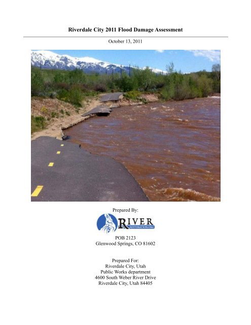
Description of Issue: Sever erosion of nearly 550 ft of bank resulting in collapse<br />
of 300’ of asphalt pathway.<br />
Structures: Bike Path<br />
Geomorphic Description: Aerial photographs from 1953, 1954, 1971, 1973, 1979,<br />
1980, 1997, 2003, 2006, and 2009 were reviewed to<br />
understand the geomorphic evolution of this reach. This<br />
portion of the <strong>Weber</strong> <strong>River</strong> was channelized in the early<br />
1970’s for the construction of I-84. Prior to channelization<br />
this reach had meanders with a similar planform to the<br />
upstream DNR reach as it exists today. Aerial photography<br />
from 1953 shows that the reach length has been reduced by<br />
over 20% (7500 feet to 5800 ft). In addition to decreasing<br />
the length and a subsequent decrease in slope the<br />
construction of the highway also narrowed the effective<br />
floodplain of the river. Historic channel patterns are also<br />
evident in the 1953 photo. These patterns indicate that the<br />
<strong>Weber</strong> <strong>River</strong> may have had a meander belt width in excess<br />
of 1500ft. Aerial Photographs from 1999 and 2009 show<br />
that virtually all of the meanders have been eliminated<br />
through channelization and the riparian corridor is less than<br />
150 ft wide. In addition to the channelization a water main<br />
crossing was placed just upstream of the failed bike path<br />
(RC-9) creating a large drop structure. The river has<br />
responded to these changes by cutting into the right bank as<br />
it attempts to adjust its flow path length. The river was<br />
cutting at this bank prior to the construction of the path in<br />
2009. Between 1997 and 2006 the bank eroded a horizontal<br />
distance of approximately 55-60 ft. Some of this bank loss<br />
was reclaimed with the construction of the path in 2009. The<br />
1971 photo shows a mid-channel bar formed immediately<br />
across the river from the area of the failed bike path.<br />
Portions of this bar were left unaltered during the<br />
construction of the highway. It is likely that during high<br />
flows this mid channel bar become inundated and provided<br />
extra conveyance. During the extended drought period that<br />
ended in 2008 riparian vegetation was established on this<br />
bar thus closing off any significant conveyance. The lack of<br />
overbank flooding and the establishment of mature riparian<br />
vegetation has effectively eliminated any overbank<br />
28
<strong>River</strong>dale <strong>City</strong> 2011 <strong>Flood</strong> <strong>Assessment</strong> October 13, 2011<br />
conveyance through this reach. Additionally there is<br />
evidence of bank toe erosion throughout this reach,<br />
indicating that the river is down cutting.<br />
Evidence of overbank flooding at downstream end of bank<br />
failure. Large amounts of driftwood caught in overgrown<br />
understory may have decreased overbank conveyance.<br />
Habitat Considerations: Throughout this reach there is a lack of habitat diversity.<br />
Channelization has created uniform flow patterns and in<br />
portions the riparian vegetation is sparse. There is little<br />
evidence of deposition through this reach. Eroded bank<br />
material is likely transported through the reach and<br />
deposited downstream of <strong>River</strong>dale <strong>City</strong>.<br />
<strong>Flood</strong> <strong>Damage</strong> Repair � $250,000-$350,000<br />
Measures: � Option 1 (<strong>Flood</strong> <strong>Damage</strong> Improved Project):<br />
o Reconstruct Bike path further northeast.<br />
o Biostabilize Bank<br />
o $50,000-$100,000 + Lands<br />
� Option 2 (<strong>Flood</strong> <strong>Damage</strong> Improved Project):<br />
o Reconstruct bike path in new alignment<br />
o Stabilize Toe<br />
o Lay river bank back at 3:1 and biostabilize<br />
o Thin out overgrown riparian vegetation on<br />
river left to open up flood conveyance<br />
channels.<br />
o $200,000 to $300,000 + Lands<br />
Photographs:<br />
29
<strong>River</strong>dale <strong>City</strong> 2011 <strong>Flood</strong> <strong>Assessment</strong> October 13, 2011<br />
30
<strong>River</strong>dale <strong>City</strong> 2011 <strong>Flood</strong> <strong>Assessment</strong> October 13, 2011<br />
31
<strong>River</strong>dale <strong>City</strong> 2011 <strong>Flood</strong> <strong>Assessment</strong> October 13, 2011<br />
32
<strong>River</strong>dale <strong>City</strong> 2011 <strong>Flood</strong> <strong>Assessment</strong> October 13, 2011<br />
33
<strong>River</strong>dale <strong>City</strong> 2011 <strong>Flood</strong> <strong>Assessment</strong> October 13, 2011<br />
34
<strong>River</strong>dale <strong>City</strong> 2011 <strong>Flood</strong> <strong>Assessment</strong> October 13, 2011<br />
35
<strong>River</strong>dale <strong>City</strong> 2011 <strong>Flood</strong> <strong>Assessment</strong> October 13, 2011<br />
<strong>Flood</strong> <strong>Assessment</strong> Point:<br />
#2‐Bank Collapse Across From <strong>River</strong>dale Mobile<br />
Estates<br />
GPS Coordinates: Waypoints RC-30 to 32<br />
Direction to <strong>Assessment</strong> Approximately 4100ft upstream from <strong>Weber</strong> <strong>River</strong> Dr. on<br />
Point: bike path across from <strong>River</strong>dale Mobile Estates<br />
Project Priority: High Moderate Low<br />
X<br />
Description of Issue: Sever erosion of approximately 325 ft of bank up to 30’<br />
deep threatening bike path.<br />
Structures: Bike Path<br />
Geomorphic Description: Aerial photographs from 1953, 1954, 1971, 1973, 1979,<br />
1980, 1997, 2003, 2006, and 2009 were reviewed to<br />
understand the geomorphic evolution of this reach. This<br />
portion of eroded bank is approximately 840 ft downstream<br />
of the failing bike path and is within the same reach. This<br />
portion of the <strong>Weber</strong> <strong>River</strong> was channelized in the late 1964<br />
for the construction the mobile home park. The reach<br />
immediately upstream of this was encroached by the<br />
construction of I-84 in the 1970’s. Aerial photography from<br />
1953 and 54 shows that at this location the <strong>Weber</strong> <strong>River</strong> had<br />
a meander belt width of 800 ft and historically the main<br />
channel of the river has shifted across over 1500 ft of active<br />
floodplain. Comparison of aerial photographs shows that the<br />
mobile home park was constructed in the same location as<br />
the main active channel in 1953. This encroachment<br />
shortened the stream length through this reach by over 20%.<br />
Additionally the width of the active floodplain was reduced<br />
from over 1500 ft to less than 900 ft. The resulting channel<br />
is completely straight and the active channel width was<br />
reduced from over 150 ft to less than 90 ft. The steeper,<br />
narrower channel has a greater transport capacity than the<br />
unaltered channel. In response to the encroachment of the<br />
mobil home park the river started to move to the river right.<br />
Aerial photos from the 1971 show a completely straight<br />
<strong>Weber</strong> <strong>River</strong> located immidatly behind mobile homes on L<br />
Street. Aerial photos from the last decade show a slightly<br />
more sinuous river. Analysis of the photographic records<br />
indicates that the river has moved nearly 80 ft to the east<br />
resulting in increased forces on the river right bank. The<br />
sustained high flows during the 2011 runoff put significant<br />
strain on the right bank across and downstream of the<br />
mobile home park.<br />
Habitat Considerations: Throughout this reach there is a lack of habitat diversity.<br />
Channelization has created uniform flow patterns and in<br />
portions the riparian vegetation is sparse. There is little<br />
36
<strong>River</strong>dale <strong>City</strong> 2011 <strong>Flood</strong> <strong>Assessment</strong> October 13, 2011<br />
evidence of deposition through this reach. Eroded bank<br />
material is likely transported through the reach and<br />
deposited downstream of <strong>River</strong>dale <strong>City</strong>.<br />
<strong>Flood</strong> <strong>Damage</strong> Repair � $30,000-$64,000<br />
Measures: � Option 1 (<strong>Flood</strong> <strong>Damage</strong> Improved Project)<br />
o Lay back right bank<br />
o Offset Bike path and allow some bank<br />
erosion<br />
o $50,000-$100,000<br />
Photographs: � IMGP0096<br />
� IMGP0098<br />
37
<strong>River</strong>dale <strong>City</strong> 2011 <strong>Flood</strong> <strong>Assessment</strong> October 13, 2011<br />
38
<strong>River</strong>dale <strong>City</strong> 2011 <strong>Flood</strong> <strong>Assessment</strong> October 13, 2011<br />
<strong>Flood</strong> <strong>Assessment</strong> Point:<br />
#3‐Frisbee Golf Course Riprap Failure<br />
GPS Coordinates: Waypoints RC-33 to 34<br />
Direction to <strong>Assessment</strong> Approximately 2400ft up path from <strong>Weber</strong> <strong>River</strong> Dr.<br />
Point:<br />
Project Priority: High Moderate Low<br />
X<br />
Description of Issue: Sever localized erosion, poorly installed rip-rap and Jhooks.<br />
Rip-rap and J-hooks failing. Bank erosion<br />
Structures: Bike Path, Rip Rap<br />
Geomorphic Description: Aerial photographs from 1953, 1954, 1971, 1973, 1979,<br />
1980, 1997, 2003, 2006, and 2009 were reviewed to<br />
understand the geomorphic evolution of this reach. This is at<br />
the downstream end of the reach that was channelized in the<br />
1960ss and 1970s with the construction of I-84 and the<br />
mobile home park. Additionally downstream of this location<br />
the river was channelized during the commercial<br />
development along <strong>River</strong>dale Rd. in the early 1970s. This<br />
reach is downstream of the mobile home park and upstream<br />
of the Crabtree Investments Property (adjacent to the Bridge<br />
over the <strong>Weber</strong> <strong>River</strong> on 4600 S/<strong>Weber</strong> <strong>River</strong> Dr.). It<br />
appears from the historic aerial photos that this reach<br />
between these two channelized reaches remained in a<br />
relatively natural state until after 1980. As the lands between<br />
the <strong>Weber</strong> <strong>River</strong> and <strong>River</strong>dale Rd. were developed during<br />
the 1980s and the <strong>River</strong>dale <strong>City</strong> park lands were being<br />
developed the river was further constrained. During this<br />
time the sinuosity of this portion of the river has decreased<br />
from 1.26 to 1.06. One of the causes of this decrease in<br />
sinuosity is a meander cutoff that happened between 1980<br />
and 1992 just downstream of the failed rip-rap area. This<br />
cutoff is part of a natural process that may have been<br />
impacted by human encroachment.<br />
Prior to this cutoff the area were the rip-rap was placed<br />
was on the outside of a bend. Just upstream of this location<br />
there is a resistant clay deposit on the right bank which has<br />
prevented the river from significantly cutting into the<br />
bank.(Photo 221, 222). At the downstream end of this clay<br />
deposit the stream expands and encounters more erodible<br />
material.<br />
Since the meander cutoff happened, a high tension<br />
power line and the bike path have been installed on the right<br />
bank. A number of J-hooks were installed on the right bank<br />
through this reach, likely to protect the path and power line<br />
alignments. Many of these J-Hooks appear to be placed to<br />
high on the bank to function properly. Their improper<br />
placement can cause adverse hydraulics on the banks<br />
resulting localized erosion.<br />
39
<strong>River</strong>dale <strong>City</strong> 2011 <strong>Flood</strong> <strong>Assessment</strong> October 13, 2011<br />
Aerial photographs show evidence of historic flow<br />
paths in the floodplains on either side of the current<br />
alignment. The open field just to the east of this rip-rap<br />
failure appears to contain one of these old river alignments.<br />
These alignments are visible because they have differing<br />
vegetation and stand out. The difference in vegetation is due<br />
to the different soils that the river deposits as it alters its<br />
alignment. Often these old channel alignments contain<br />
deposits of gravel and small cobbles that are easily<br />
mobilized during flood events.<br />
Just downstream of this rip-rap failure a mid channel<br />
bar has become vegetated, the J-hooks have caused<br />
aggradation around this bar decreasing capacity on the right<br />
of the vegetated bar. At low flows this mid channel bar<br />
becomes connected to the right bank and functions as a large<br />
vegetated point bar. A riffle has formed at the head of this<br />
point bar, just downstream of the failed riprap. These<br />
morphologic changes have altered the local hydraulics and<br />
put greater stress on the right bank. Lastly there is less<br />
riparian vegetation along this portion of the river. The<br />
increased bank stress combined with the adverse hydraulics<br />
created by the non systemically planned J-hooks, the lack of<br />
bank stabilizing vegetation and the easily erodible channel<br />
deposit resulted in the bank failing between 2006 and 2010.<br />
The riprap was placed between two of the J-hooks to<br />
prevent further damage of the bank. It’s likely that while the<br />
rip-rap failed it succeeded in preventing further damage to<br />
the path. However, the rip-rap installation was not extensive<br />
enough to truly address this situation. An engineered riprap<br />
design for this location could extend over 300 ft.<br />
Habitat Considerations: Throughout this reach there is a lack of habitat diversity.<br />
Channelization has created uniform flow patterns. There is<br />
some evidence of deposition in this reach. Eroded bank<br />
material is likely transported through the reach and<br />
deposited downstream of <strong>River</strong>dale <strong>City</strong>.<br />
<strong>Flood</strong> <strong>Damage</strong> Repair: � $25,000-$50,000<br />
Measures: � Option 1(<strong>Flood</strong> <strong>Damage</strong> Replacement Project)<br />
o Move Path to East (<strong>City</strong> Owned Land)<br />
o Lay back right bank<br />
o Bio stabilize right bank.<br />
o Remove J-hooks. Use as Toe Boulders<br />
o Place Excess J-hook boulders in <strong>River</strong> as<br />
habitat/squirt boat features.<br />
o Construct overbank relief channel<br />
o $50,000-$100,000<br />
Photographs: � IMGP0099<br />
� IMGP0221<br />
� IMGP0222<br />
40
<strong>River</strong>dale <strong>City</strong> 2011 <strong>Flood</strong> <strong>Assessment</strong> October 13, 2011<br />
41
<strong>River</strong>dale <strong>City</strong> 2011 <strong>Flood</strong> <strong>Assessment</strong> October 13, 2011<br />
42
<strong>River</strong>dale <strong>City</strong> 2011 <strong>Flood</strong> <strong>Assessment</strong> October 13, 2011<br />
43
<strong>River</strong>dale <strong>City</strong> 2011 <strong>Flood</strong> <strong>Assessment</strong> October 13, 2011<br />
<strong>Flood</strong> <strong>Assessment</strong> Point:<br />
#4‐<strong>River</strong>dale Play Park, Grade control and Riprap<br />
Failure<br />
GPS Coordinates: 8-16-11: Pts 9 & 10<br />
Direction to <strong>Assessment</strong> Approximately 600 ft downstream on the bike path from the<br />
Point: South <strong>Weber</strong> <strong>River</strong> Dr. trailhead.<br />
Project Priority: High Moderate Low<br />
X<br />
Description of Issue: Grouted Riprap appears to be failing and as a result the<br />
whitewater wave no longer functions. Probing indicates<br />
8’deep hole upstream of the grouted grade control and an 8’<br />
deep hole downstream of the structure. Design drawings<br />
indicate that the cutoff wall above the lower drop is only 5’<br />
deep; it is likely that the grouted riprap has been undercut.<br />
Additionally the grouted grade control on the left bank<br />
between the two structures has also failed and there is<br />
significant erosion in the viewing area on the left bank at the<br />
lower drop. This erosion extend downstream over 350 ft.<br />
This is a High Priority project for a number of reasons: 1)<br />
the <strong>River</strong>dale Whitewater Park is a world class whitewater<br />
feature that brings tourism $ into <strong>River</strong>dale, 2) Potential<br />
significant entrapment hazard to boaters/swimmers<br />
(There is a popular rope swing just upstream of the<br />
lower structure)<br />
Structures: Sewer Line, Kayak Wave, Bike Path<br />
Geomorphic Description: This grouted grouted grade control structure was<br />
constructed in 2005. The primary goal of this structure is to<br />
protect the sewer line crossing. The structure was also<br />
designed to create a whitewater wave. Based on design<br />
drawings there is a 5’ concrete cutoff wall upstream of the<br />
lower drop structure.<br />
Like much of the <strong>Weber</strong> <strong>River</strong> through <strong>River</strong>dale <strong>City</strong>,<br />
this reach has been channelized during the urbanization of<br />
<strong>River</strong>dale in the 1970s. Historically, this reach of the river<br />
was more similar to the upstream reaches that pass through<br />
the DNR property; it was a dynamic, aggrading system. The<br />
modified channel has a greater sediment transport capacity<br />
and is capable of transporting most of the alluvium supplied<br />
by the upstream reaches. As a result of this excess transport<br />
capacity the <strong>Weber</strong> river is degrading through much of<br />
<strong>River</strong>dale <strong>City</strong>. This is evidenced by bank toe erosion and<br />
little evidence of sediment deposition throughout the<br />
<strong>River</strong>dale reach. While it is difficult to assess the condition<br />
of the structure due to high flows, the presence of 8’ deep<br />
holes upstream and downstream of the structure indicate that<br />
the 2011 flood flows were sufficiently large, and of a<br />
sufficient duration that they may have undercut the 5 foot<br />
cutoff wall and eroded under the grouted grade control. It is<br />
44
<strong>River</strong>dale <strong>City</strong> 2011 <strong>Flood</strong> <strong>Assessment</strong> October 13, 2011<br />
not uncommon for grouted grouted grade control structures<br />
to be undercut. Additionally, the downstream hydraulics<br />
have caused significant bank erosion on the right bank of the<br />
river. General channel degradation is likely downstream of<br />
the grade control structure. Due to the excessive channel<br />
scour the structure no longer functions as designed.<br />
Habitat Considerations: This structure provides better fish passage than the upstream<br />
drop structures.<br />
<strong>Flood</strong> <strong>Damage</strong> Repair: � $250,000-$350,000<br />
Measures: � Option 1 (<strong>Flood</strong> <strong>Damage</strong> Lower Structure Improved<br />
Project)<br />
o Re-Grout riprap<br />
o Fill voids under structure with Flowable Fill<br />
o Replace Cutoff Wall (sheet pile)<br />
o Biostablize Left Bank<br />
o Repair downstream grade control<br />
o $200,000-$300,000<br />
� Option 2- (Replace Lower Structure, Alternate<br />
Project)<br />
o Remove grouted rip-rip<br />
o Construct new structure out of large boulders<br />
embedded below scour depth<br />
o Install pre-cast “Wave Blocks” to create play<br />
wave<br />
o Install Sheet pile cutoff.<br />
o Protect viewing area with boulder and<br />
flagstone<br />
o $350,000-$650,000<br />
Photographs: � IMGP0159<br />
� IMGP0160<br />
� IMGP0161<br />
� IMGP 2796<br />
45
<strong>River</strong>dale <strong>City</strong> 2011 <strong>Flood</strong> <strong>Assessment</strong> October 13, 2011<br />
46
<strong>River</strong>dale <strong>City</strong> 2011 <strong>Flood</strong> <strong>Assessment</strong> October 13, 2011<br />
47
<strong>River</strong>dale <strong>City</strong> 2011 <strong>Flood</strong> <strong>Assessment</strong> October 13, 2011<br />
48
<strong>River</strong>dale <strong>City</strong> 2011 <strong>Flood</strong> <strong>Assessment</strong> October 13, 2011<br />
49
<strong>River</strong>dale <strong>City</strong> 2011 <strong>Flood</strong> <strong>Assessment</strong> October 13, 2011<br />
50
<strong>River</strong>dale <strong>City</strong> 2011 <strong>Flood</strong> <strong>Assessment</strong> October 13, 2011<br />
51
<strong>River</strong>dale <strong>City</strong> 2011 <strong>Flood</strong> <strong>Assessment</strong> October 13, 2011<br />
52
<strong>River</strong>dale <strong>City</strong> 2011 <strong>Flood</strong> <strong>Assessment</strong> October 13, 2011<br />
53
<strong>River</strong>dale <strong>City</strong> 2011 <strong>Flood</strong> <strong>Assessment</strong> October 13, 2011<br />
<strong>Flood</strong> <strong>Assessment</strong> Point:<br />
#5‐54” RCP outfall @ W4400S & S <strong>Weber</strong> <strong>River</strong> Dr.<br />
GPS Coordinates: 8-16-11 Point 20<br />
Direction to <strong>Assessment</strong> On left bank at east end of W4400S @ S <strong>Weber</strong> <strong>River</strong> Dr.<br />
Point: left turn<br />
Project Priority: High Moderate Low<br />
X<br />
Description of Issue: Rip-Rap around outfall is failing. Evidence of piping around<br />
headwall.<br />
Structures: Stormwater Outfall.<br />
Geomorphic Description: The riprap has been compromised by the high flows of<br />
2011. The rip-rap has insufficient depth, toe stability and<br />
does not appear to have any filter material.<br />
Habitat Considerations: Sediment source.<br />
<strong>Damage</strong> <strong>Assessment</strong> � $15,000-$35,000<br />
Measures: � Option 1 (<strong>Flood</strong> <strong>Damage</strong> Replacement Project)<br />
o Repair rip-rap with sufficient blanket depth<br />
and filter material<br />
o Opportunity to create stormwater treatment<br />
wetland?<br />
o Stabilize toe<br />
o $30,000-$64,000<br />
Photographs: � IMGP0165<br />
� IMGP0166<br />
54
<strong>River</strong>dale <strong>City</strong> 2011 <strong>Flood</strong> <strong>Assessment</strong> October 13, 2011<br />
55
<strong>River</strong>dale <strong>City</strong> 2011 <strong>Flood</strong> <strong>Assessment</strong> October 13, 2011<br />
56
<strong>River</strong>dale <strong>City</strong> 2011 <strong>Flood</strong> <strong>Assessment</strong> October 13, 2011<br />
<strong>Flood</strong> <strong>Assessment</strong> Point:<br />
#6 #14‐Two 36” RCP outfalls and Rip‐rap @ <strong>River</strong>dale<br />
Rd. Bridge<br />
GPS Coordinates: 8-16-11 Point 22 & 23<br />
Direction to <strong>Assessment</strong> On left bank just downstream of <strong>River</strong>dale Rd. Bridge<br />
Point:<br />
Project Priority: High Moderate Low<br />
X<br />
Description of Issue: Rip-Rap around outfall is failing. Evidence of piping around<br />
headwall. Filter Fabric exposed. Riprap under bridge failing.<br />
No fabric evident under bridge. This is intended to be a<br />
continuous blanket of rip-rap. There is insufficient toe<br />
stability.<br />
Structures: <strong>River</strong>dale Rd. Bridge Abutment and Stormwater Outfall<br />
Geomorphic Description: The riprap has been compromised by the high flows of<br />
2011. The rip-rap has insufficient depth and does not appear<br />
to have any filter material. There is also evidence of bank<br />
erosion up and downstream of this location. Some of the<br />
erosion may be cause by the rip-rap blanket; if the rip-rap<br />
does not extend up and downstream a sufficient distance,<br />
and is not keyed in properly it can cause adverse hydraulics.<br />
There is also a failed J-hook structure that may have further<br />
exacerbated the adverse hydraulics.<br />
Habitat Considerations: Sediment source.<br />
<strong>Damage</strong> <strong>Assessment</strong> � $20,000-$40,000<br />
Measures: � Option 1 (<strong>Flood</strong> Mitigation Replacement Project)<br />
o Repair rip-rap with sufficient blanket depth<br />
and filter material.<br />
o Bio stabilize up and downstream.,<br />
o Remove J-hook and use boulders for Toe<br />
protection or habitat enhancement.<br />
o Opportunity to create stormwater treatment<br />
wetland at stormwater outfalls?<br />
o Stabilize Toe<br />
o $35,000-$64,000<br />
Photographs: � IMGP0171<br />
� IMGP0172<br />
� IMGP0173<br />
57
<strong>River</strong>dale <strong>City</strong> 2011 <strong>Flood</strong> <strong>Assessment</strong> October 13, 2011<br />
58
<strong>River</strong>dale <strong>City</strong> 2011 <strong>Flood</strong> <strong>Assessment</strong> October 13, 2011<br />
59
<strong>River</strong>dale <strong>City</strong> 2011 <strong>Flood</strong> <strong>Assessment</strong> October 13, 2011<br />
60
<strong>River</strong>dale <strong>City</strong> 2011 <strong>Flood</strong> <strong>Assessment</strong> October 13, 2011<br />
<strong>Flood</strong> <strong>Assessment</strong> Point:<br />
#7‐Concrete Revetment at Les Schwab Tire<br />
GPS Coordinates: 8-16-11 Point 26<br />
Direction to <strong>Assessment</strong> On left bank approximately 450 ft upstream of the <strong>River</strong>dale<br />
Point: Rd. Bridge on the bike path.<br />
Project Priority: High Moderate Low<br />
X<br />
Description of Issue: There is 15’x50’ concrete slab poured on the bank,<br />
ostensibly done for bank protection. The concrete slab is<br />
undercut and failing. The exposed slab may be causing<br />
adverse hydraulics exacerbating bank erosion and may<br />
create a safety hazard. There is insufficient toe stability.<br />
Structures: Bank protection, sculpture<br />
Geomorphic Description: This concrete slab is not constructed properly for bank<br />
protection. Generally, flexible rip-rap is preferable to a<br />
concrete slab due to its ability to conform to the changing<br />
river bank.<br />
Habitat Considerations: Degraded Riparian habitat, source of sediment<br />
<strong>Flood</strong> <strong>Damage</strong> Repair � $5,000-$10,000<br />
Measures: � Option 1 (<strong>Flood</strong> <strong>Damage</strong> Replacement Project)<br />
o Remove concrete<br />
o Stabilize Toe<br />
o Biostabilize bank<br />
o $35,000-$64,000<br />
Photographs: � IMGP0175<br />
� IMGP0176<br />
� IMGP0177<br />
61
<strong>River</strong>dale <strong>City</strong> 2011 <strong>Flood</strong> <strong>Assessment</strong> October 13, 2011<br />
62
<strong>River</strong>dale <strong>City</strong> 2011 <strong>Flood</strong> <strong>Assessment</strong> October 13, 2011<br />
63
<strong>River</strong>dale <strong>City</strong> 2011 <strong>Flood</strong> <strong>Assessment</strong> October 13, 2011<br />
64
<strong>River</strong>dale <strong>City</strong> 2011 <strong>Flood</strong> <strong>Assessment</strong> October 13, 2011<br />
<strong>Flood</strong> <strong>Assessment</strong> Point:<br />
#8‐Riprap at 4600S and <strong>Weber</strong> <strong>River</strong> Dr. Bridge<br />
GPS Coordinates: 8-16-11 Points 28 30<br />
Direction to <strong>Assessment</strong><br />
Point:<br />
Under Bridge at 4600S and <strong>Weber</strong> <strong>River</strong> Dr.<br />
Project Priority: High Moderate Low<br />
X<br />
Description of <strong>Damage</strong>: The rip-rap failing and unstable.<br />
Structures: Bridge<br />
Geomorphic Description: The riprap blanket is not thick enough, does not extend far<br />
enough, does not appear to have fabric, and is not keyed in.<br />
Additionally, the riprap may be inadequately sized and may<br />
not be angular enough. There is insufficient toe stability.<br />
Habitat Considerations: Source of sediment<br />
<strong>Flood</strong> <strong>Damage</strong> Repair: � $25,000-$50,000<br />
Measures: � Option 1 (<strong>Flood</strong> <strong>Damage</strong> Replacement Project)<br />
o Install properly engineered revetment,<br />
extending up and downstream sufficient<br />
distance, and keyed in<br />
o Biostabilize up and downstream of revetment<br />
o Stabilize Toe<br />
o $30,000-$64,000<br />
Photographs: � IMGP0178<br />
65
<strong>River</strong>dale <strong>City</strong> 2011 <strong>Flood</strong> <strong>Assessment</strong> October 13, 2011<br />
66
<strong>River</strong>dale <strong>City</strong> 2011 <strong>Flood</strong> <strong>Assessment</strong> October 13, 2011<br />
<strong>Flood</strong> <strong>Assessment</strong> Point:<br />
#9 & #14‐Creekside Trailhead Path Erosion @ <strong>River</strong><br />
Glen Subdivision<br />
GPS Coordinates: 8-16-11 Point 39, 40, 41, 42<br />
Direction to <strong>Assessment</strong><br />
Point:<br />
At the junction of the Creekside trail and the <strong>Weber</strong> <strong>River</strong><br />
Pathway. Approximately 1000ft on the bike path upstream<br />
from north trail head.<br />
Project Priority: High Moderate Low<br />
X<br />
Description of <strong>Damage</strong>: The path that leads from the <strong>River</strong> Bend Subdivision was<br />
completely eroded by overbank flooding. This path was<br />
reconstructed immediately after the 2011 flood event. 275 ft<br />
of split rail fence destroyed, 275 ft path destroyed. There are<br />
also issues with the stormwater conveyance at this location.<br />
There is a drainage channel that discharges at the west end<br />
of the Creekside trail. During high flow events this structure<br />
backs up, causing flooding in the <strong>River</strong> Bend subdivision.<br />
Structures: Path, Fence, stormwater return channel, homes.<br />
Geomorphic Description: This portion of the <strong>Weber</strong> <strong>River</strong> <strong>Flood</strong>plain has historically<br />
been very active. Historic aerial photos from prior to 1971<br />
show that the active channel of the <strong>Weber</strong> <strong>River</strong> flowed<br />
through this area. The historic channel passed directly across<br />
the junction of the two paths, continued northwest directly<br />
through what is now Wildcat Storage and the trailhead<br />
facility. The construction of I-15 and Parker Drive has<br />
encroached on the active channel at this point, forcing the<br />
river east, into its current, channelized location. The river<br />
overbanks approximately 500 ft south of the trail junction<br />
on the Pathway. FEMA mapping indicates that the trail<br />
junction is in ZONE AE and the majority of the Creekside<br />
Trail is in the 500 year floodplain. During 2011 runoff this<br />
area was inundated by a 10-year flood, indicating that the<br />
FEMA information May need updating.<br />
It’s important to note that the DFIRM identifies most of this<br />
area as 100-year and 500-year floodplain. This was a ten<br />
year event; this area should be remapped.<br />
Also we may want to separate this into two damage sites.<br />
Habitat Considerations: None<br />
<strong>Flood</strong> <strong>Damage</strong> Repair: � $5,000-$15,000<br />
67
<strong>River</strong>dale <strong>City</strong> 2011 <strong>Flood</strong> <strong>Assessment</strong> October 13, 2011<br />
Measures: � Option 1(<strong>Flood</strong> <strong>Damage</strong> Replacement)<br />
o Repair path<br />
o Repair fence<br />
o Biostabilize left bank at location of overbank.<br />
o $30,000-$64,000<br />
� Option 2 (<strong>Flood</strong> Mitigation Project)<br />
o Rebuild path to handle overbank flows<br />
o Remove fence to facilitate overbank flows<br />
o Create overbank flow path between <strong>Weber</strong><br />
Parkway and <strong>River</strong>bend Subdivision<br />
o Reconstruct <strong>Weber</strong> Pathway to have<br />
boardwalk to allow overbank flows<br />
o Biostabilze overbank area<br />
o Construct return flow channel upstream of<br />
North trailhead and downstream of trail<br />
junction.<br />
o Build offset levee along property lines<br />
o Install pump station at trailhead to pump<br />
stormwater against floodflow head, discharge<br />
downstream in <strong>Weber</strong> <strong>River</strong>.<br />
o $250,000-$500,000<br />
Photographs: � IMGP0192 Trailhead<br />
� IMGP0193 Looking upstream flood channel<br />
� IMGP0195 Bank failure at overbank area<br />
� IMGP0196 Looking downstream at overbank area,<br />
flood flow path.<br />
68
<strong>River</strong>dale <strong>City</strong> 2011 <strong>Flood</strong> <strong>Assessment</strong> October 13, 2011<br />
69
<strong>River</strong>dale <strong>City</strong> 2011 <strong>Flood</strong> <strong>Assessment</strong> October 13, 2011<br />
70
<strong>River</strong>dale <strong>City</strong> 2011 <strong>Flood</strong> <strong>Assessment</strong> October 13, 2011<br />
71
<strong>River</strong>dale <strong>City</strong> 2011 <strong>Flood</strong> <strong>Assessment</strong> October 13, 2011<br />
72
<strong>River</strong>dale <strong>City</strong> 2011 <strong>Flood</strong> <strong>Assessment</strong> October 13, 2011<br />
73
<strong>River</strong>dale <strong>City</strong> 2011 <strong>Flood</strong> <strong>Assessment</strong> October 13, 2011<br />
74
<strong>River</strong>dale <strong>City</strong> 2011 <strong>Flood</strong> <strong>Assessment</strong> October 13, 2011<br />
75
<strong>River</strong>dale <strong>City</strong> 2011 <strong>Flood</strong> <strong>Assessment</strong> October 13, 2011<br />
76
<strong>River</strong>dale <strong>City</strong> 2011 <strong>Flood</strong> <strong>Assessment</strong> October 13, 2011<br />
<strong>Flood</strong> <strong>Assessment</strong> Point:<br />
#10‐Failed Bank Stabilization<br />
GPS Coordinates: 8-16-11 Points 46<br />
Direction to <strong>Assessment</strong> This specific location is at the Junction of the Hunter Creek<br />
Point: Trail and the <strong>Weber</strong> Parkway See also Failed J-Hooks Point<br />
50 (8-16-11)<br />
Project Priority: High Moderate Low<br />
X<br />
Description of <strong>Damage</strong>: Non systemically planned constructed J-hooks and localized<br />
erosion<br />
Structures: J-hooks, Path<br />
Geomorphic Description: Similar to other location along the <strong>Weber</strong> <strong>River</strong>, these<br />
structure were placed to prevent bank erosion and the<br />
subsequent migration of the river channel. Installed in the<br />
1980s or early 1990, these structures may have been<br />
intended to reduce shear stress on the bank by forcing the<br />
flow towards the centerline of the channel. Many of these<br />
structures were designed without consideration of systemic<br />
response. Other stabilization methods may be more<br />
appropriate for this location<br />
Habitat Considerations: j-hooks cause erosion which contributes to non-point source<br />
sediment pollution.<br />
<strong>Flood</strong> <strong>Damage</strong> Repair: � $20,000-$40,000<br />
Measures: � Option 1 (<strong>Flood</strong> <strong>Damage</strong> Replacement Project)<br />
o Remove J-hook structures<br />
o Use boulders for toe protection/Stabilization<br />
o Biostabilize bank<br />
o Toe Stability<br />
o $35,000 - $64,000<br />
Photographs: � IMGP0203<br />
� IMGP0205<br />
� IMGP0206<br />
77
<strong>River</strong>dale <strong>City</strong> 2011 <strong>Flood</strong> <strong>Assessment</strong> October 13, 2011<br />
78
<strong>River</strong>dale <strong>City</strong> 2011 <strong>Flood</strong> <strong>Assessment</strong> October 13, 2011<br />
79
<strong>River</strong>dale <strong>City</strong> 2011 <strong>Flood</strong> <strong>Assessment</strong> October 13, 2011<br />
80
<strong>River</strong>dale <strong>City</strong> 2011 <strong>Flood</strong> <strong>Assessment</strong> October 13, 2011<br />
<strong>Flood</strong> <strong>Assessment</strong> Point:<br />
#11‐Failed Bank Stabilization<br />
GPS Coordinates: 8-16-11 Points 50, 51<br />
Direction to <strong>Assessment</strong> Upstream end is approximately 330ft downstream of the<br />
Point: <strong>River</strong>dale Kayak Park on the Pathway<br />
Project Priority: High Moderate Low<br />
X<br />
Description of <strong>Damage</strong>: Numerous failed J-hook structures, failed rip-rap and eroded<br />
banks and resulted bank failure is approximately 700’ long<br />
and 10’ high.<br />
Structures: Path, Homes, Land<br />
Geomorphic Description: These structures (rip-rap and J-hooks) were installed in<br />
response to the rivers channelized flow path to protect land<br />
and the Parkway. The residential areas to the west of this<br />
location were constructed in the late 1970s and early 1980s.<br />
Aerial photography from the 1950s shows that the location<br />
of the <strong>River</strong> Valley Subdivision was a historic flow path for<br />
the <strong>Weber</strong> <strong>River</strong>. Prior to the subdivision development the<br />
<strong>Weber</strong> <strong>River</strong>s geomorphically active floodplain was more<br />
than 1000ft wide. The historic photos also show a large<br />
oxbow flood channel located in the exact location of 4300 S<br />
(A.K.A. Oxbow Dr.) and <strong>River</strong> Valley Dr. Presently the<br />
<strong>River</strong> is constrained to a corridor that is 100 to 150 ft wide.<br />
Habitat Considerations: Source of non-point source sediment pollution.<br />
<strong>Flood</strong> <strong>Damage</strong> Repair � $100,000-$200,000<br />
Measures: � Option 1-(<strong>Flood</strong> <strong>Damage</strong> Replacement)<br />
o 700 ft of bank stabilization<br />
o Remove J-Hooks and use boulders for toe<br />
protection<br />
o Import material to protect bank.<br />
o $200,000-$350,000<br />
� Option 2-(<strong>Flood</strong> Improvement, Improved Project)<br />
o Remove upper bank boulders and riprap and<br />
place 150’ D.S. to connect left bank levee<br />
(100’ Long)<br />
o Improving D.S. flood overflow channel.<br />
o $64,000<br />
� Options 3-(<strong>Flood</strong> Mitigation Project)<br />
o Remove upper bank boulders and riprap and<br />
place 150’ D.S. to connect left bank levee<br />
(100’ Long)<br />
o Improving D.S. flood overflow channel.<br />
o Realign Bike Path away from <strong>River</strong>.<br />
o Biostabilize Left Bank<br />
o $85,000-$120,000<br />
Photographs: � IMGP0211<br />
81
<strong>River</strong>dale <strong>City</strong> 2011 <strong>Flood</strong> <strong>Assessment</strong> October 13, 2011<br />
� IMGP0212<br />
� IMGP0213<br />
� IMGP0214<br />
� IMGP0215<br />
82
<strong>River</strong>dale <strong>City</strong> 2011 <strong>Flood</strong> <strong>Assessment</strong> October 13, 2011<br />
83
<strong>River</strong>dale <strong>City</strong> 2011 <strong>Flood</strong> <strong>Assessment</strong> October 13, 2011<br />
84
<strong>River</strong>dale <strong>City</strong> 2011 <strong>Flood</strong> <strong>Assessment</strong> October 13, 2011<br />
85
<strong>River</strong>dale <strong>City</strong> 2011 <strong>Flood</strong> <strong>Assessment</strong> October 13, 2011<br />
86
<strong>River</strong>dale <strong>City</strong> 2011 <strong>Flood</strong> <strong>Assessment</strong> October 13, 2011<br />
<strong>Flood</strong> <strong>Assessment</strong> Point:<br />
#12‐Failed Bank Stabilization<br />
GPS Coordinates: 8-19-11 Point 54<br />
Direction to <strong>Assessment</strong> <strong>River</strong> right approximately 1600 ft upstream on the bike path<br />
Point: of the 4600 S/<strong>Weber</strong> <strong>River</strong> Dr. Bridge<br />
Project Priority: High Moderate Low<br />
X<br />
Description of <strong>Damage</strong>: Failed J-hook has and localized bank failure<br />
Structures: Path, J-Bank stabilization<br />
Geomorphic Description: Similar to other location along the <strong>Weber</strong> <strong>River</strong>, these<br />
structure may have been placed to prevent bank erosion and<br />
the subsequent migration of the river channel. Installed in<br />
the 1980s or early 1990, these structures are usually<br />
intended to reduce shear stress on the bank by forcing the<br />
flow towards the centerline of the channel. Many of these<br />
structures were installed without consideration of the<br />
systemic response.<br />
Habitat Considerations: Source of non-point source sediment pollution.<br />
<strong>Flood</strong> <strong>Damage</strong> Repair � $15,000-$35,000<br />
Measures: � Option 1 (<strong>Flood</strong> <strong>Damage</strong> Replacement Project)<br />
o Remove J-hook and use boulders for toe<br />
protection or habitat structures<br />
o Biostabilize bank<br />
o $35,000-$64,000<br />
Photographs: � IMGP0216<br />
87
<strong>River</strong>dale <strong>City</strong> 2011 <strong>Flood</strong> <strong>Assessment</strong> October 13, 2011<br />
88