The Progressive Teacher Vol 03 Issue 05
This issue of The Progressive Teacher focuses on "Teaching of Social Studies". The magazine provides guidance to the teachers by their peers and school leaders for tackling challenges with innovative ideas.
This issue of The Progressive Teacher focuses on "Teaching of Social Studies". The magazine provides guidance to the teachers by their peers and school leaders for tackling challenges with innovative ideas.

You also want an ePaper? Increase the reach of your titles
YUMPU automatically turns print PDFs into web optimized ePapers that Google loves.
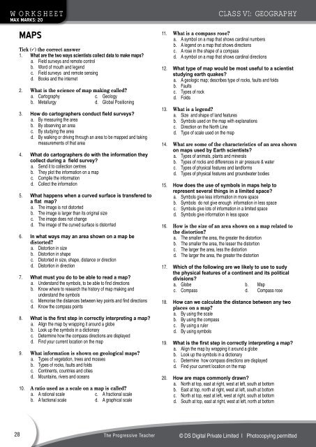
worksheet<br />
Max Marks: 20<br />
Maps<br />
Tick ( ) the correct answer<br />
1. What are the two ways scientists collect data to make maps?<br />
a. Field surveys and remote control<br />
b. Word of mouth and legend<br />
c. Field surveys and remote sensing<br />
d. Books and the internet<br />
2. What is the science of map making called?<br />
a. Cartography c. Geology<br />
b. Metallurgy d. Global Positioning<br />
3. How do cartographers conduct field surveys?<br />
a. By measuring the area<br />
b. By observing an area<br />
c. By studying the area<br />
d. By walking or driving through an area to be mapped and taking<br />
measurements of that area<br />
4. What do cartographers do with the information they<br />
collect during a field survey?<br />
a. Send it to collection centres<br />
b. <strong>The</strong>y plot the information on a map<br />
c. Compile the information<br />
d. Collect the information<br />
5. What happens when a curved surface is transfered to<br />
a flat map?<br />
a. <strong>The</strong> image is not distorted<br />
b. <strong>The</strong> image is larger than its original size<br />
c. <strong>The</strong> image does not change<br />
d. <strong>The</strong> image of the curved surface is distorrted<br />
6. In what ways may an area shown on a map be<br />
distorted?<br />
a. Distortion in size<br />
b. Distortion in shape<br />
c. Distorted in size, shape, distance or direction<br />
d. Distortion in direction<br />
7. What must you do to be able to read a map?<br />
a. Understand the symbols, to be able to find directions<br />
b. Know where to research the history of map making and<br />
understand the symbols<br />
c. Memorise the distances between key points and find directions<br />
d. Know the compass points<br />
8. What is the first step in correctly interpreting a map?<br />
a. Align the map by wrapping it around a globe<br />
b. Look up the symbols in a dictionary<br />
c. Determine how the compass directions are displayed<br />
d. Find your current location on the map<br />
9. What information is shown on geological maps?<br />
a. Types of vegetation, trees and mosses<br />
b. Types of rocks, faults and folds<br />
c. Continents, countries and cities<br />
d. Mountains, rivers and oceans<br />
10. A ratio used as a scale on a map is called?<br />
a. A rational scale c. A fractional scale<br />
b. A factional scale d. A graphical scale<br />
Class VI: geography<br />
11. What is a compass rose?<br />
a. A symbol on a map that shows cardinal numbers<br />
b. A legend on a map that shows directions<br />
c. A rose in the shape of a compass<br />
d. A symbol on a map that shows cardinal directions<br />
12. What type of map would be most useful to a scientist<br />
studying earth quakes?<br />
a. A geologic map; describes type of rocks, faults and folds<br />
b. Faults<br />
c. Types of rock<br />
d. Folds<br />
13. What is a legend?<br />
a. Size and shape of land features<br />
b. Symbols used on the map with explanations<br />
c. Direction on the North Line<br />
d. Type of scale used on the map<br />
14. What are some of the characteristics of an area shown<br />
on maps used by Earth scientists?<br />
a. Types of animals, plants and minerals<br />
b. Types of rocks and differences in air pressure & water<br />
c. Types of physical features and landforms<br />
d. Types of physical features and groundwater bodies<br />
15. How does the use of symbols in maps help to<br />
represent several things in a limited space?<br />
a. Symbols give less information in more space<br />
b. Symbols do not give enough information in less space<br />
c. Symbols give lots of information in a limited space<br />
d. Symbols give information in less space<br />
16. How is the size of an area shown on a map related to<br />
the distortion?<br />
a. <strong>The</strong> smaller the area, the greater the distortion<br />
b. <strong>The</strong> smaller the area, the lesser the distortion<br />
c. <strong>The</strong> larger the area, less the distortion<br />
d. <strong>The</strong> larger the area, the greater the distortion<br />
17. Which of the following are we likely to use to sudy<br />
the physical features of a continent and its political<br />
divisions?<br />
a. Globe b. Map<br />
c. Compass d. Compass rose<br />
18. How can we calculate the distance between any two<br />
places on a map?<br />
a. By using the scale<br />
b. By using the compass<br />
c. By using a ruler<br />
d. By using symbols<br />
19. What is the first step in correctly interpreting a map?<br />
a. Align the map by wrapping it around a globe<br />
b. Look up the symbols in a dictionary<br />
c. Determine how compass directions are displayed<br />
d. Find your current location on the map<br />
20. How are maps commonly drawn?<br />
a. North at top, east at right, west at left, south at bottom<br />
b. East at top, north at right, west at left, south at bottom<br />
c. North at top, east at left, west at right, south at bottom<br />
d. South at top, east at right, west at left, north at bottom<br />
28<br />
<strong>The</strong> <strong>Progressive</strong> <strong>Teacher</strong><br />
© DS Digital Private Limited I Photocopying permitted