
You also want an ePaper? Increase the reach of your titles
YUMPU automatically turns print PDFs into web optimized ePapers that Google loves.
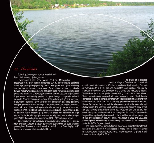
22. Dwudniaki<br />
Zbiornik pożwirowy usytuowany jest obok wsi<br />
Dwudniaki, złożony z jednego akwenu.<br />
Powierzchnia lustra wody wynosi 19,6 ha. Maksymalna<br />
głębokość 7 m, przy średniej głębokości 3,7 m. Teren dookoła zbiornika<br />
został wykupiony przez prywatnego właściciela i przeznaczony na zabudowę<br />
ośrodka rekreacyjno-wypoczynkowego. Brzegi stawu łagodne, porośnięte<br />
trawą z nielicznymi drzewami. Linia brzegowa słabo rozwinięta, gdzieniegdzie<br />
porośnięte trzciną. Dno piaszczysto-żwirowe, pokryte osadami organicznymi<br />
i porośnięte roślinnością podwodną, przy brzegach łagodnie schodzi<br />
do wody. Zbiornik charakteryzuje duża ilość podwodnych górek i wypłyceń.<br />
Stosunkowo niewielki i płytki zbiornik jest siedliskiem dla wielu gatunków<br />
cennych gospodarczo ryb, takich jak: karp, amur, leszcz, lin, węgorz, sandacz,<br />
szczupak, sum. Staw jest systematycznie zarybiany: karpiem, amurem,<br />
leszczem, linem, narybkiem suma, sandacza, szczupaka i wylęgiem węgorza.<br />
W ostatnich latach znacznie pogorszyła się jakość wód zbiornika, do tego<br />
stopnia że dwukrotnie wystąpiły masowe zakwity sinic, a w monitorowanym<br />
przez WIOS Tarnów kąpielisku w sezonie 2002 i 2003 zakazano kąpieli.<br />
Zbiornik powstały po wydobyciu żwiru, usytuowany wzdłuż lewego brzegu<br />
rzeki <strong>Dunajec</strong>. Złożony z trzech zbiorników połączonych ze sobą wąskimi<br />
przesmykami. Powierzchnia lustra wody wynosi ok. 15 ha. Średnia głębokość<br />
to 3 m., przy maksymalnej głębokości 7,5 m.<br />
The gravel pit is situated<br />
near the village of Dwudniaki and consists of<br />
a single pond with an area of 19.6 ha., a maximum depth reaching 7 m and<br />
an average depth of 3.7 m. The area around the basin has been acquired by<br />
a private entrepreneur and developed into a leisure and recreational facility.<br />
The banks of the pond are gentle, covered with grass and the occasional tree.<br />
The shoreline is underdeveloped, with reeds growing in places. The bottom is<br />
composed of sand and gravel, covered with organic sediment and overgrown<br />
with underwater plants. The bottom has very gentle slopes towards the banks.<br />
Unique features of the pond include a large number of underwater hills and<br />
shallow areas. The relatively small and shallow pond is home to many prized<br />
fish such as carp, amur, bream, tench, eel, pikeperch, pike and catfish, with<br />
which it is systematically stocked. In the past years, the quality of the water in<br />
the pond has significantly deteriorated, to the extent that massive appearances<br />
of blue-green algae have occurred twice. As a result, in 2002 and 2003, the<br />
swimming area, monitored by the Voivodship Inspectorate for Environmental<br />
Protection in Tarnów, was closed.<br />
The Basin, formed as a result of gravel excavation, is situated along the left<br />
bank of the <strong>Dunajec</strong> River. It is composed of three ponds, connected together<br />
by narrow gorges. Its area is around 15 ha., its average depth is up to 3 m and<br />
it has a maximum depth of 7.5 m.