Department of Earth Science Sierra College - Cengage Learning
Department of Earth Science Sierra College - Cengage Learning
Department of Earth Science Sierra College - Cengage Learning

You also want an ePaper? Increase the reach of your titles
YUMPU automatically turns print PDFs into web optimized ePapers that Google loves.
Northern California<br />
Geology Geolo<br />
<strong>of</strong> Northern<br />
California<br />
Frank DeCourten<br />
<strong>Department</strong> <strong>of</strong> <strong>Earth</strong> <strong>Science</strong> <strong>Sierra</strong> <strong>College</strong><br />
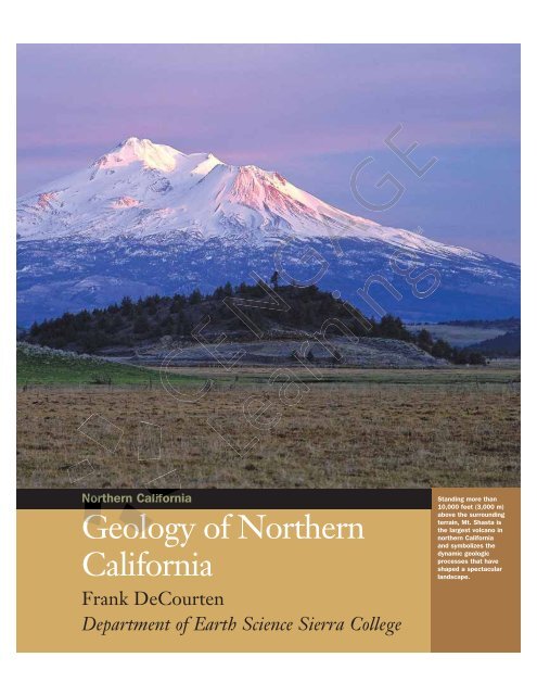
Standing more than<br />
10,000 feet (3,000 m)<br />
above the surrounding<br />
terrain, Mt. Shasta is<br />
the largest volcano in<br />
northern California<br />
and symbolizes the<br />
dynamic geologic<br />
processes that have<br />
shaped a spectacular<br />
landscape.
ESSENTIAL QUESTIONS TO ASK<br />
Northern California.1 Introduction<br />
� What are northern California’s physiographic provinces?<br />
� What is the Farallon subduction zone?<br />
� What two types <strong>of</strong> plate boundaries exist in northern California al today?<br />
� What are terranes, how do they originate, and why are they th important in northern<br />
California?<br />
Northern California.2 The <strong>Sierra</strong> Nevada: California’s alifornia’s Geologic Ge<br />
Backbone<br />
� What is the <strong>Sierra</strong> Nevada batholith?<br />
� What kinds <strong>of</strong> rocks surround the <strong>Sierra</strong> rra Nevada batholith? batholi<br />
� When and how was the modern <strong>Sierra</strong> ra Nevada uplifted?<br />
� What types <strong>of</strong> gold deposits occur in the e <strong>Sierra</strong> Nevada?<br />
� What is the Mother Lode? e?<br />
Northern California.3 The Klamath MMountains<br />
� In what ways are the t Klamath ath Mountains and an the <strong>Sierra</strong> Nevada Neevada<br />
similar?<br />
� What kinds ds <strong>of</strong> rocks ro comprise the ophiolites o in the Klamath ath Mountains M and what tectonic<br />
events do they signify?<br />
� What mineral ineral resources occur occu in the th Klamath Mountains? ntai<br />
Northern California.4 Ca rnia The e Gr Great Valley<br />
� What factors fa s have led to the th formation <strong>of</strong> fertile soils in i the he Great Valley? Valle<br />
� What at was the t origin <strong>of</strong> the sedimentary ime y rocks in the Great Grea Valley Sequence? Seq<br />
�� What is the origin ori <strong>of</strong> the natural l gas produced p duced in the Great Gr Valley?<br />
�� Why y is the Great Gre Valley so prone to chronic chron flooding? ooding<br />
Northern rn California.5 Ca The Northe Northern Coast Coa Ranges<br />
� What is the Franciscan complex and how did it form?<br />
� How did the San Andreas Andr s fault system originate? or<br />
�� What is the Salinian inian block?<br />
� How old are the northern norther Coast Ranges Ra and what tectonic forces elevated them?<br />
Northern California.6 ornia.6 Volcanoes olcan <strong>of</strong> the Cascade Range and Modoc<br />
Pl Plateau<br />
� What California fornia volcanoes volca are part <strong>of</strong> the Cascade Range?<br />
�� What is the Cascadia Cascad subduction zone?<br />
�� What kind <strong>of</strong> o volcanic activity typifies the Cascade Range?<br />
� Why is Mount Mou Lassen an especially interesting volcano in the Cascade Range?<br />
Northern California.7 Ca The Basin and Range <strong>of</strong> Northeast California<br />
�� What Wh tectonic forces are responsible for the pattern <strong>of</strong> alternating mountains and valleys<br />
in the Basin and Range province?<br />
� What mountains and basins in northern California belong to the Basin and Range province?<br />
Northern California.8 The Northern California Ice Ages<br />
� During what time periods did northern California experience Ice Age conditions?<br />
� What landscape features resulted from the Pleistocene Epoch glaciations in northern<br />
California?<br />
� How did the Pleistocene landscape <strong>of</strong> northern California differ from the modern setting?<br />
Northern California.9 Northern California <strong>Earth</strong>quakes<br />
� What plate tectonic settings are associated with northern California earthquakes?<br />
� What is the likelihood <strong>of</strong> another major earthquake in northern California?<br />
� What might be the effects <strong>of</strong> a large northern California earthquake?<br />
� Given the severity <strong>of</strong> the potential hazards, how can the effects <strong>of</strong> earthquakes be minimized<br />
in northern California?<br />
Northern California.10 Living on the Edge: Coastal Hazards in<br />
Northern California<br />
� In comparison to the coast <strong>of</strong> southern California, why is the northern California shoreline<br />
so rugged and scenic?<br />
� What coastal hazards exist in northern California?<br />
� How do human activities affect coastal hazards?
2 Geology <strong>of</strong> Northern California<br />
Northern California.1<br />
Introduction<br />
California’s Varied Landscape: California is arguably the best<br />
place in the world to study geology. Few areas <strong>of</strong> comparable<br />
size are as geologically varied, physiographically diverse, or so<br />
spectacularly scenic as the Golden State. California’s abundant<br />
natural resources reflect in large measure its rich geological<br />
history, and earthquakes, floods, and mass wasting events<br />
underscore the importance <strong>of</strong> ongoing geologic processes for<br />
residents and visitors. With the boundary between two <strong>of</strong> the<br />
largest lithospheric plates on the planet running for more<br />
than 1,300 kilometers along the western side <strong>of</strong> the state,<br />
California is an outstanding natural laboratory for studying<br />
<strong>Earth</strong> processes and plate interactions.<br />
During the 1960s and 1970s, our understanding <strong>of</strong> earth<br />
dynamics shifted dramatically as the modern theory <strong>of</strong> plate<br />
tectonics was developed and refined. Many <strong>of</strong> the new concepts<br />
<strong>of</strong> that era either were developed in California or were<br />
specifically formulated to explain and/or reinterpret its<br />
incredibly varied geological features. Today, with a new theoretical<br />
framework and vastly improved tools for exploration ration<br />
and analysis, scientists continue to consider California nia a<br />
geologic paradise.<br />
The rocks in California tell an amazing story ry <strong>of</strong> the evolution<br />
<strong>of</strong> land and life at the edge <strong>of</strong> North America. merica. Although Altho<br />
it would require many years to explore all the geologic wonders<br />
in California, a first course in physical physi geology logy is an<br />
excellent start to a lifetime <strong>of</strong> fascinating inat adventureeinthe in the<br />
Golden State. The purpose <strong>of</strong> this chapter cha is threefold: (1) 1 to<br />
introduce the broader aspects <strong>of</strong> California’s lifornia’s geologic setting,<br />
(2) to outline the major tectonic events nts that have shaped s its<br />
landscape over geologic time, and (3) to examine the impacts<br />
on humans <strong>of</strong> the state’s ongoing geologic evolution. I also<br />
hope you will consider consid this chapter chap an invitationnto to begin<br />
your own lifelong exploration explo n<strong>of</strong>on <strong>of</strong> one <strong>of</strong> the mostt magnifi- magn<br />
cent landscapes pes in the world. wo<br />
California’s Physiographic Physio hic Provinces: Pro The California rnia<br />
landscape can be divided intoo a dozen doz regions <strong>of</strong> distinctive<br />
and characteristic aracterist geology, landforms, climate, cl geomorphic<br />
trends, soils and an vegetation, andd drainage. draina These natural<br />
areas are known as physiographic phic provinces. provinc After the geologic<br />
alignment ent <strong>of</strong> o the state’s major ajor mountain mou systems, most<br />
<strong>of</strong> the geomorphic orphi provinces ince are oriented in a northwest-tosoutheast<br />
trend end (Figure (F e NC.1). Hence H some <strong>of</strong> the provinces,<br />
such as the <strong>Sierra</strong> Nevada ada and the Coast Ranges, extend from<br />
the northern part <strong>of</strong> the state te to the southern portion. For the<br />
purposes <strong>of</strong> the present discussion, we will arbitrarily define<br />
northern California as the region between Monterey Bay<br />
(latitude approximately 36.5° N) and the California–Oregon<br />
border. In this portion <strong>of</strong> California, seven natural physiographic<br />
provinces comprise the landscape: the northern<br />
<strong>Sierra</strong> Nevada, the northern Coast Ranges, the northern<br />
Central Valley, the Klamath Mountains, the Cascade Range,<br />
the Modoc Plateau, and portions <strong>of</strong> the Basin and Range.<br />
Though there are consistent geologic patterns within each <strong>of</strong><br />
these regions that make them distinctive and identifiable,<br />
none can be regarded as simple or monotonous. Each <strong>of</strong> the<br />
physiographic provinces in northern California is a varied<br />
and fascinating geological realm with endless opportunities<br />
for applying the knowledge you have gaineddin in your physical<br />
geology course. Collectively, they represent sent a region <strong>of</strong> such<br />
complex origin that scientists have yet too develop completely co<br />
satisfactory explanations <strong>of</strong> all <strong>of</strong> the geologic ogic features featu in this<br />
varied terrain. The common attribute ribute <strong>of</strong> all the he physiographic<br />
physiograp<br />
provinces <strong>of</strong> northern California nia is that, one on way ay or another, an<br />
each reflects the consequences es <strong>of</strong> plate tectonic tecton interactions nt<br />
along the western margin <strong>of</strong>f North America over the past<br />
500 million years.<br />
Geologic Map <strong>of</strong> f California: Calif Geologic maps m are indispensable<br />
assets in exploring oring the natural natu history and geologic setting<br />
<strong>of</strong> any region. Such uch maps show the distribution tion <strong>of</strong> rock<br />
types and d ages age on the surface, surfac along with information mati ma about<br />
the orientation entation <strong>of</strong> the t various ario rock bodies, the e nature na <strong>of</strong> their<br />
contact ct with adjacent rock ck masses, m and the e trends and extent<br />
<strong>of</strong> geologic ologic structures such su as faults and folds. olds. This information<br />
tio is essential in unraveling unra the geologic eolog history <strong>of</strong> a region regi<br />
because becau it reveals spatial sp patterns in the distribution dis bution <strong>of</strong> rocks ro<br />
<strong>of</strong> various variou types, ages, and nd degree ee <strong>of</strong> deformation deformat n that reflect re<br />
the tectonic tectoni and geologic events ven <strong>of</strong> the past. In addition, ii geologic<br />
ogic maps are <strong>of</strong> critical importance mporta e in locating l surface and<br />
subsurface deposits <strong>of</strong> earth resources sourc and in identifying the<br />
areas are most susceptible ible to various variou geologic geol hazards.<br />
� Figure NC.11 The Physiographic Provinces <strong>of</strong> California<br />
Map courtesy <strong>of</strong> the U.S. Geological Survey
Reproduced with permission, California Californ <strong>Department</strong> <strong>of</strong> Conservation, Conservatio California Geological eologica<br />
Survey<br />
� Figure NC.2 Geological Map <strong>of</strong> California<br />
The geologic map <strong>of</strong> California (Figure NC.2) has been<br />
compiled by the California Geological Survey over many<br />
decades <strong>of</strong> geologic mapping. This map is scaled to show<br />
the entire state and, as such, it portrays only the broader<br />
distribution <strong>of</strong> various California rocks and structures.<br />
Northern California.1 Introduction 3<br />
Nonetheless, you will notice at a glance the strong similarity<br />
between the physiographic provinces in California and the<br />
distribution <strong>of</strong> various rock types. For example, notice the<br />
similarity in location, trend, and extent <strong>of</strong> the <strong>Sierra</strong><br />
Nevada province and the large area <strong>of</strong> red, blue, and green
4 Geology <strong>of</strong> Northern California<br />
� Figure NC.3 Interactions between The Farallon, Pacific, and North American plates over the past 40 million years.<br />
40 M.Y.A 20 M.Y.A 0 M.Y.A<br />
Pacific<br />
plate<br />
Pacific-<br />
Farallon<br />
Ridge<br />
Farallon<br />
plate<br />
North<br />
American<br />
plate<br />
Farallon<br />
plate<br />
Pacificremnant<br />
Farallon<br />
Ridge<br />
Incipient<br />
San Andreas<br />
transform<br />
fault<br />
Pacific plate<br />
Gulf <strong>of</strong><br />
Farallon<br />
Mexico plate<br />
remnant<br />
Mexico<br />
colors on the geologic map. These colors represent nt the<br />
Mesozoic-age plutonic igneous rocks that comprise e the<br />
core <strong>of</strong> the <strong>Sierra</strong> Nevada (red) and the older r rocks ro that hat<br />
were metamorphosed by the emplacement <strong>of</strong> the th magma<br />
(blue and green). A very similar pattern is observed in the<br />
Klamath Mountains physiographic province ovi northwest <strong>of</strong><br />
the <strong>Sierra</strong> Nevada, suggesting that the two tw regions ions share<br />
some common geologic traits. The e similarity si between een the th<br />
physiographic provinces <strong>of</strong> California rni and the distribution<br />
<strong>of</strong> various types and ages <strong>of</strong> rock in the state underscores<br />
und<br />
the importance <strong>of</strong> the geologic foundation ndation in shaping sha the<br />
character <strong>of</strong> the landscape.<br />
The Westward ard Migration: For the past 500 million years<br />
convergent plate tectonic tect interactions terac have prevailed ailed along<br />
the western ern margin <strong>of</strong> o North America. A Early y in the<br />
Mesozoic Era, ra, about 200 20 million llion years ye ago, the rate <strong>of</strong> plate plat<br />
convergence increased reased significantly ficantly as the ancient superconcontinent <strong>of</strong> Pangaea ang began to break up. u The North Americann<br />
plate separated eparated from f the northern part <strong>of</strong> the supercontinent<br />
via the e opening openin <strong>of</strong> the Atlantic c Oceanic Ocean basin. Seafloor<br />
spreading in this basin propelled led the North Nor American plate<br />
to the west while the Eurasia and African Afric plates moved in<br />
the opposite e direction. direc Several Seve different ff oceanic plates were<br />
subducted under the leading edge ed <strong>of</strong> the North American<br />
plate as it slowly moved ved west. The T last and largest <strong>of</strong> the<br />
oceanic plates to descend beneath bene North America was the<br />
Farallon plate, remnants <strong>of</strong> which still exist along the<br />
western margin <strong>of</strong> North and Central America. This plate<br />
tectonic interaction along the western edge <strong>of</strong> North<br />
America produced the Farallon subduction zone, which<br />
was established in mid-Mesozoic time and persisted from<br />
some 160 million years ago until about 30 million years ago.<br />
Many <strong>of</strong> the major geologic trends in California are the<br />
result <strong>of</strong> this long history <strong>of</strong> plate convergence.<br />
Origin <strong>of</strong> the Modern Transform Plate Boundary: The<br />
Farallon plate originated at an oceanic ridge to the west and<br />
North<br />
American<br />
plate<br />
Queen<br />
Charlotte<br />
transform<br />
fault<br />
Juan de Fuca Fuc<br />
platee<br />
Incipient ent<br />
San Sa Andreas<br />
transform transfo<br />
fault<br />
plate pla Pacific Pacific<br />
Cocos<br />
plate<br />
North<br />
American<br />
plate<br />
Present day<br />
volcanoes<br />
Gulf <strong>of</strong><br />
Mexico<br />
southwest thwes <strong>of</strong> North America. Ame On the other othe side ide <strong>of</strong> o that<br />
ancient spreading spr center, the he Pacific Pa fic plate plat was sliding to the<br />
west, while the Farallon lon plate p e moved mov in the opposite direction<br />
tio toward the advancing ancing margin ma in <strong>of</strong> North America. A little<br />
less than 30 million ion years ago, the western edge <strong>of</strong> North<br />
America collided ded with, ith, and eventually eve overran, the Pacific-<br />
Farallon ridge dge near n the e latitude latit <strong>of</strong> modern Los Angeles. As a<br />
consequence <strong>of</strong> this th collision, li the North American plate<br />
came e into contact con ct with wit the Pacific plate (Figure NC.3).<br />
The collision between North America and the Pacific-<br />
Farallon n ridge ended en plate convergence in the California<br />
region regio and established e the modern transform plate<br />
boundary. bounda After the initial collision <strong>of</strong> the ridge and the<br />
continent, continen the transform plate boundary expanded north<br />
and south so as North America continued moving west, overrunning<br />
ru more <strong>of</strong> the ridge in the process (Figure NC.4).<br />
The relatively small Cocos, Rivera, and Juan de Fuca plates<br />
represent modern remnants <strong>of</strong> the ancient Farallon plate.<br />
The famous San Andreas fault system developed as a consequence<br />
<strong>of</strong> the transform plate boundary between the North<br />
America and the Pacific plates.<br />
The geologic setting <strong>of</strong> modern northern California is<br />
thus influenced by two different kinds <strong>of</strong> boundaries<br />
between the North American and oceanic plates to the<br />
west: a transform boundary from Monterey Bay to Cape<br />
Mendocino and a remnant convergent boundary to the<br />
north. We will explore the consequences <strong>of</strong> these interactions<br />
in more detail in the sections that follow.<br />
California and Accreted Terranes: One <strong>of</strong> the consequences<br />
<strong>of</strong> the long history <strong>of</strong> plate convergence along the<br />
western margin <strong>of</strong> North America was the accretion <strong>of</strong><br />
numerous blocks <strong>of</strong> rock to stable crust <strong>of</strong> the continent.<br />
Such blocks added to the edge <strong>of</strong> a continent by plate convergence<br />
are known as accretionary terranes, or simply<br />
terranes. Five hundred million years ago, there was no land<br />
where the Pacific Coast now stands. The crust <strong>of</strong> California
� Figure NC.4 Major terranes <strong>of</strong> western North America. In<br />
addition to the Franciscan Complex and the Salinian block<br />
illustrated here, dozens <strong>of</strong> smaller terranes have been identified in<br />
northern California.<br />
Seward<br />
Peninsula<br />
Ruby<br />
Nixon Fork<br />
North<br />
Slope<br />
Endicott<br />
Wrangellia Yukon–<br />
Tanana<br />
Alexander<br />
Wrangellia<br />
Franciscann<br />
Complex<br />
Salina<br />
300 km<br />
Wrangellia<br />
Alaska<br />
Stikine<br />
Yukon<br />
Wrangellia gellia<br />
Klamath<br />
Moutainss<br />
Canada C<br />
U. S. A. A.<br />
U. S. A.<br />
Mexico<br />
has since been n assembled asse in piecemeal fashion as seamounts,<br />
island arcs, coral reefs, and small continental blocks that were<br />
carried on subducting oceanic plates collided with the western<br />
edge <strong>of</strong> the continent and were embedded into the existing<br />
margin. The rocks in the various terranes were<br />
metamorphosed and deformed as each was sutured into<br />
North America like pieces <strong>of</strong> a mosaic. In this manner, North<br />
America grew incrementally westward with the addition <strong>of</strong><br />
each fragment. Geologists are in general agreement that<br />
about 100 such terranes were accreted to the western margin<br />
<strong>of</strong> North America since the breakup <strong>of</strong> Pangaea about<br />
Northern California.2 The <strong>Sierra</strong> Nevada: California’s Geologic Backbone 5<br />
200 million years ago. Several others were added in earlier<br />
accretionary events in the Paleozoic Era, before North<br />
America separated from Pangaea. It was not until Cenozoic<br />
time that all <strong>of</strong> the terranes were wer in place along the Pacific<br />
Coast and the modern California fornia landscape began to emerge.<br />
California, as a whole, , therefore represents a geologic<br />
collage, an amalgam <strong>of</strong> pieces ces assembled assem through the convergence<br />
<strong>of</strong> plates s along the west edge <strong>of</strong> North America<br />
over the past 500 0 million years. year Northern orthern California is especially<br />
intriguing because here both bo a remnant r<br />
<strong>of</strong> an ancient<br />
convergent boundary ndary and the modern m transform boundary<br />
to the south continue tinue to shape the t landscape. It is not surprising<br />
g that geologists ists find northern no California such a fascinating<br />
region. It is a place where the geologic past meets the<br />
dynamic c present, and there is no place in the world better<br />
suited s for r geologic geolo exploration. Let’s et’s slo look a little closer.<br />
Section Northern California.1 alifornia.1 Summary S<br />
● The geology and d landscape landsca <strong>of</strong> northern California is<br />
extremely y varied, v d, with seven different physiographic<br />
provinces, each with distinctive distincti rock k assemblages and<br />
geologic histories. ories.<br />
● Convergent nvergent plate ate boundaries b have existed for 500 million<br />
n years in the northern n California region. After North<br />
Am America erica separated from Pangaea early in the Mesozoic<br />
EEra,<br />
the e rate <strong>of</strong> convergence increased as several oceanic<br />
plat plates were es subducted under the west-moving continent.<br />
● The subduction <strong>of</strong> the Farallon plate in the Mesozoic<br />
Era<br />
resulted in many <strong>of</strong> the geologic trends that can be<br />
ob observed in modern California. About 30 million years<br />
ago, plate convergence ended as the transform boundary<br />
between the Pacific and North American plates began to<br />
develop. The unique geologic setting <strong>of</strong> modern northern<br />
California is shaped by both a remnant <strong>of</strong> the<br />
Mesozoic subduction zone and the continuing evolution<br />
<strong>of</strong> the more recent transform plate boundary.<br />
Northern California.2<br />
The <strong>Sierra</strong> Nevada: California’s<br />
Geologic Backbone<br />
The <strong>Sierra</strong> Nevada is California’s best known mountain<br />
system. Stretching for more than 700 kilometers from<br />
Lake Almanor in the north to Tehachapi in the south, this<br />
northwest-trending mountain system is home to three<br />
national parks and the highest peak in the coterminous<br />
United States at Mount Whitney (14,495 feet/4,418 meters<br />
above sea level). Winter storms passing east from the Pacific<br />
Ocean over the high <strong>Sierra</strong> Nevada produce heavy snowfall<br />
that is an essential supply <strong>of</strong> water to the entire state.<br />
Materials released from the weathering <strong>of</strong> <strong>Sierra</strong> Nevada
6 Geology <strong>of</strong> Northern California<br />
bedrock help sustain the fertility <strong>of</strong> California’s rich agricultural<br />
soils. It was in the <strong>Sierra</strong> Nevada foothills that gold<br />
was discovered in the 1800s, and the course <strong>of</strong> California<br />
history was forever changed. Without the <strong>Sierra</strong> Nevada,<br />
California would simply not be California.<br />
The bedrock <strong>of</strong> the <strong>Sierra</strong> Nevada is dominated by the<br />
Mesozoic <strong>Sierra</strong> Nevada batholith, one <strong>of</strong> the largest and<br />
most complex masses <strong>of</strong> granitic rock in the world. Adjacent<br />
to the batholith, and sometimes as xenoliths and ro<strong>of</strong><br />
pendants within it, are older Mesozoic and Paleozoic metamorphic<br />
rocks that were invaded by the subterranean<br />
magma. More recent episodes in the evolution <strong>of</strong> the <strong>Sierra</strong><br />
Nevada are documented by Cenozoic volcanic and sedimentary<br />
rocks that rest on the granite-metamorphic basement.<br />
The <strong>Sierra</strong> Nevada Batholith: The geologic map <strong>of</strong><br />
California clearly indicates that the Mesozoic granite <strong>of</strong> the<br />
<strong>Sierra</strong> Nevada batholith comprises the core <strong>of</strong> the <strong>Sierra</strong><br />
Nevada. Vast exposures <strong>of</strong> such light-colored plutonic rock<br />
in the high country <strong>of</strong> Yosemite, Kings Canyon, and<br />
Sequoia National Parks, is in part what led John Muir to<br />
refer to the <strong>Sierra</strong> as “the range <strong>of</strong> light” (Figure NC.5).<br />
The <strong>Sierra</strong> Nevada batholith is a complex assemblage <strong>of</strong><br />
perhaps as many as 200 individual plutons representing enting<br />
magma bodies emplaced mostly between 140 million and<br />
80 million years ago at depths <strong>of</strong> 10 to 30 0 kilometers ki rs<br />
� Figure NC.5 Vast exposures <strong>of</strong> granitic rock characterize erize the <strong>Sierra</strong> Nevada, John Muir’s “Range Rang <strong>of</strong> f Light”. Light<br />
beneath the surface. Most <strong>of</strong> the plutons comprising the<br />
<strong>Sierra</strong> Nevada batholith consist <strong>of</strong> felsic rock such as granite,<br />
rich in light-colored quartz, potassium feldspar, and<br />
sodium-rich plagioclase (Figure NC.6). Some Som <strong>of</strong> the plutons<br />
are richer in the darker ferromagnesian nesian minerals and<br />
consist <strong>of</strong> rock more similar to diorite or gabbro.<br />
The <strong>Sierra</strong> Nevada batholith represents nts the deep roots<br />
<strong>of</strong> a Mesozoic volcanic arc that at developed deve along the he west- w<br />
ern margin <strong>of</strong> North America ca above the Farallon allon subduc- su<br />
tion zone. In this ancient subduction zone, zon magma mag<br />
was<br />
produced by partial melting and migrated upward up through<br />
older crustal material to build a chain <strong>of</strong> andesitic ande volcanoes<br />
that rivaled the modern mod Andes ndes Mountains Moun <strong>of</strong> South<br />
America. Recent geologic eologic studies studi have revealed evidence <strong>of</strong><br />
large calderas formed ed by explosive eruptions in this ancient<br />
volcanic chain. chain Late in the Cenozoic Era, the uplift up upli <strong>of</strong> the<br />
<strong>Sierra</strong> Nevada resulted res d in the nearly complete plete erosion <strong>of</strong><br />
the volcanic olcanic edifice that t originally or concealed ealed the batholitic<br />
rocks. . However, isolated isolate remnants <strong>of</strong> the e ancient volcanoes<br />
can ca still ill be seen in places along g the crest rest <strong>of</strong> the range ran<br />
(Figure (Figu NC.7).<br />
Paleozoic-Mesozoic Paleo<br />
Accretionary A tionary Terranes Terr nes <strong>of</strong> the<br />
Northern <strong>Sierra</strong> Nevada: d : The T e magma that th formed the<br />
<strong>Sierra</strong> Nevada Nev batholith was as emplaced emp ced into in older rocks that<br />
either accumulated on the seafloor afloor west <strong>of</strong> the margin <strong>of</strong><br />
Frank DeCourten
Frank DeCourten<br />
Dick Hilton<br />
� Figure NC.6 Close up <strong>of</strong> granite from the <strong>Sierra</strong> Nevada<br />
Batholith. Dark crystals are biotite and hornblende, white crytals are<br />
plagioclase and potassium feldspar, and the gray translucent crystals<br />
are quartz.<br />
� Figure NC.7 Dark-colored d rocks rock <strong>of</strong> the Ritter Range in the t eastern<br />
<strong>Sierra</strong> Nevada are remnants ants <strong>of</strong> o the Mesozoic zoic <strong>Sierra</strong> volcanic volc<br />
arc.<br />
Paleozoic North America or were accreted to the edge <strong>of</strong><br />
the continent in convergent plate interactions that preceded<br />
the Farallon subduction zone. These old rocks were<br />
deformed and metamorphosed during several different<br />
accretion events and altered by the heat and fluids associated<br />
with magma rising from the Farallon subduction zone in<br />
later Mesozoic time. Metamorphic rocks such as marble,<br />
slate, schist, serpentinite, and greenstone are common in<br />
the pre-batholithic terranes <strong>of</strong> the <strong>Sierra</strong> Nevada. Some <strong>of</strong><br />
Frank DeCourten De<br />
Northern California.2 The <strong>Sierra</strong> Nevada: California’s Geologic Backbone 7<br />
� Figure NC.8 Folds in these Paleozoic sedimentary rocks along the<br />
Yuba River were developed during the collision between a block <strong>of</strong><br />
oceanic rocks and western edge <strong>of</strong> North America in the Mesozoic Era.<br />
these rocks have been affected by multiple periods <strong>of</strong> metamorphism.<br />
In addition, these rocks are commonly folded<br />
and faulted by the compressional stress generated along<br />
ancient convergent plate boundaries (Figure NC.8).<br />
It has taken geologists many decades to unscramble the<br />
complicated history recorded in the metamorphic rocks surrounding<br />
the <strong>Sierra</strong> Nevada batholith. Within the granitic<br />
core <strong>of</strong> the <strong>Sierra</strong> Nevada, exposures <strong>of</strong> these rocks are<br />
found as ro<strong>of</strong> pendants and xenoliths (Figure NC.9) preserved<br />
in the plutonic rocks. In the foothills north and west<br />
<strong>of</strong> the batholithic core <strong>of</strong> the <strong>Sierra</strong> Nevada, extensive exposures<br />
<strong>of</strong> metamorphic rocks have revealed a complex history<br />
<strong>of</strong> metamorphism and accretion. Because there has been<br />
much greater Cenozoic uplift in the southern <strong>Sierra</strong> Nevada<br />
than in the north, erosion there has progressed to a deeper<br />
level in the crust and much <strong>of</strong> the older rock that formerly<br />
surrounded the granitic plutons has been removed.<br />
Within the western foothills metamorphic belt, geologists<br />
have identified three primary units <strong>of</strong> metamorphosed<br />
rocks that are separated from each other by major faults.<br />
These faults probably were produced when seamounts,<br />
undersea volcanic arcs, oceanic crust, or other fragments <strong>of</strong><br />
lithosphere collided with the edge <strong>of</strong> North America. The<br />
metamorphosed and deformed rocks comprising these
8 Geology <strong>of</strong> Northern California<br />
� Figure NC.9 Dark-colored xenoliths in <strong>Sierra</strong> granite represent<br />
fragments <strong>of</strong> older rock assimilated into the magma prior to<br />
crystallization.<br />
terranes are almost entirely <strong>of</strong> oceanic origin, and generally nerally<br />
older than the tectonic events that sutured them to the<br />
North American continent. Some represent mafic magma ma<br />
erupted by undersea volcanoes, and the characteristic acteris pillow<br />
structures can still be observed (Figure NC.10). Other O<br />
terranes include oceanic sedimentary rocks roc such uch as chert,<br />
mudstone, and limestone that have e been metamorphosed morphosed<br />
to varying degrees. There is strong g evidence e that some ome <strong>of</strong> o<br />
the accreted fragments traveled thousands <strong>of</strong> kilometers k<br />
before the now-vanished plates carrying arrying them sank sa into<br />
ancient subduction zones. Ophiolites, es, sequences <strong>of</strong> rocks<br />
representing oceanic lithosphere, are present resent in i some terranes,<br />
and probably obab originated as fragments splintered from<br />
the descending ding oceanic ocean plates es sutured sutu into the various vario terranes.<br />
Adding ding complexity complexi to o some <strong>of</strong> the terranes es is the<br />
� Figure NC.10 The rounded ro pillow illow structures stru in this outcrop <strong>of</strong><br />
mildly metmorposed morp basalt in the western metmorphic belt indicate<br />
eruption on <strong>of</strong> lava on o the seafloor.<br />
Frank DeCourten<br />
Frank DeCourten<br />
presence <strong>of</strong> mélanges, chaotic mixtures <strong>of</strong> deformed and<br />
metamorphosed rocks that are formed in subduction zone<br />
settings. We will learn more about ophiolites and mélanges<br />
when we explore the northern Coast Range, ang where they<br />
formed within the much younger Farallon on subduction su zone.<br />
Cenozoic Rocks <strong>of</strong> the <strong>Sierra</strong> Nevada: da: At the end e <strong>of</strong> the<br />
Mesozoic Era about 65 million years ago, , the <strong>Sierra</strong> Sier Nevada<br />
was an elevated volcanic terrain n perched perch on a complex base- b<br />
ment comprised <strong>of</strong> older rocks cks intruded by the concealed conc<br />
<strong>Sierra</strong> Nevada batholith. As s Cenozoic time (the e<br />
Tertiary<br />
Period) began, igneous activity ity appears to have hav temporarily<br />
subsided in the <strong>Sierra</strong> region, and erosion was wa beginning to<br />
attack the summits s <strong>of</strong> the th dormant ant volcanoes. volcano The volcanic<br />
highland extended into what is now n western Nevada and the<br />
ancient shore <strong>of</strong> the e ancestral Pacific Pac Ocean was located<br />
along the he foothills foo <strong>of</strong> f the dormant d volcanic arc cin in central<br />
California. rnia. Rivers draining ning the volcanic highland ghlan ran west<br />
across s the site <strong>of</strong> the modern ode <strong>Sierra</strong> Nevada. ada. These The ancient<br />
rivers steadily wore away aw the volcanic bedrock, and a transported<br />
po great quantities <strong>of</strong> sediment t to the th ocean basin to the t<br />
west. This his long period peri <strong>of</strong> erosion in the Early Ea Cenozoic Era E<br />
produced oduce a pronounced plain, pl which has since been een elevated elev<br />
hundreds <strong>of</strong> o feet above the he floors flo rs <strong>of</strong> modern stream valleys<br />
in n the <strong>Sierra</strong> Sierr Nevada region n (Figure (Figu NC.11). NC.<br />
During the Eocene ne Epoch, Epo , about abou 50 5 million years ago,<br />
river-deposited riv<br />
sediments ediments began be an to accumulate in the<br />
ancient anc river systems sys ems <strong>of</strong> the <strong>Sierra</strong> Sie Nevada. In the stream<br />
channels, coarse oarse gravel ravel deposits formed. On the floodplains,<br />
fine sand, sand silt, and mud accumulated. These riverdeposited<br />
ited sediments s iment are still preserved in many places in<br />
the foothills <strong>of</strong> o the he <strong>Sierra</strong> S Nevada as colorful exposures <strong>of</strong><br />
conglomerate, glomerate, sandstone, sa and mudstone. Geologic map-<br />
ping in the early 1900s demonstrated that exposures <strong>of</strong> the<br />
ancient ancien river gravels g were aligned as elongated ribbons, indi-<br />
cating the th location and drainage pattern <strong>of</strong> the 50-million-<br />
year-old river channels. Soon after the California Gold<br />
Rush R h began, prospectors discovered that some <strong>of</strong> the<br />
Eocene-age E river gravels contained rich concentrations <strong>of</strong><br />
gold in the form <strong>of</strong> nuggets, flakes, and fine particles. The<br />
richest gravel deposits became known as the “auriferous<br />
gravels.” Such gold-bearing sediments were intensely<br />
mined and processed in the mid-1800s, primarily by washing<br />
away the weakly-cemented material with powerful<br />
steams <strong>of</strong> water and separating the small gold particles from<br />
the loosened sand, pebbles, and cobbles (Figure NC.12).<br />
Known as hydraulic mining, this process was phased out<br />
after 1884 because so much sediment had been washed<br />
from the <strong>Sierra</strong> slopes that agriculture and river navigation<br />
downstream in the Central Valley was being adversely<br />
affected. The best exposures <strong>of</strong> the auriferous gravels today<br />
are in the scars and excavations left from the hydraulic mining<br />
activities more than century ago.<br />
During the Oligocene and Miocene Epochs, 35 million<br />
to 5 million years ago, volcanic activity resumed along what<br />
is today the crest <strong>of</strong> the <strong>Sierra</strong> Nevada and areas to the east.<br />
The initial eruptions were violent caldera-forming explosions<br />
that sent great flows <strong>of</strong> ash and fragments <strong>of</strong> volcanic
Frank DeCourten<br />
Bettmann/Corbis<br />
rock surging west through the canyons carved by the<br />
Eocene-age rivers. These pyroclastic deposits hardened<br />
into tuffs and welded tuffs that partially filled the ancient<br />
canyons (Figure NC.13). The later eruptions produced<br />
basalt flows, volcanic breccias, and volcanic mudflow<br />
deposits known as lahars. The Tertiary-age volcanic rocks<br />
completely filled some <strong>of</strong> the valleys <strong>of</strong> the western slope <strong>of</strong><br />
Northern California.2 The <strong>Sierra</strong> Nevada: California’s Geologic Backbone 9<br />
� Figure NC.11 Beyond the deep canyon <strong>of</strong> the Yuba River on the <strong>Sierra</strong> Nevada west slope, the flat surface reflects a lengthy interval <strong>of</strong> erosion in<br />
the early Tertiary Period.<br />
� Figure NC.12 Hydraulic mining in the <strong>Sierra</strong> Nevada involved<br />
wash washing Eocene sediments with powerful jets <strong>of</strong> water. Photo hoto taken take<br />
in 1905<br />
at Junction on City, City California.<br />
Frank DeCourten<br />
� Figure NC.13 Oligocene tuff near Soda Springs, California<br />
consists <strong>of</strong> ash partcles and white pumice fragments welded into a<br />
coherent rock.<br />
the ancestral <strong>Sierra</strong> Nevada, forcing the ancient streams<br />
from their channels. In the past few million years, as the<br />
modern <strong>Sierra</strong> Nevada rose, vigorous down-cutting has left<br />
the erosion-resistant valley-filling Tertiary volcanic rocks<br />
perched high above modern river beds. Sinuous ridges
10 Geology <strong>of</strong> Northern California<br />
capped by Tertiary volcanic rocks demonstrate the phenomena<br />
<strong>of</strong> inverted topography in many places in the<br />
<strong>Sierra</strong> foothills (Figure NC.14).<br />
Recent Uplift <strong>of</strong> the <strong>Sierra</strong> Nevada: Though the rocks<br />
<strong>of</strong> the <strong>Sierra</strong> Nevada document a long history <strong>of</strong> geologic<br />
unrest, good evidence suggests that the modern range<br />
reflects a relatively recent pulse <strong>of</strong> uplift. Although the<br />
<strong>Sierra</strong> Nevada was probably an elevated tract <strong>of</strong> land since<br />
the mid-Mesozoic Era, recent geologic studies suggest that<br />
5 million to 10 million years ago, the mountain system rose<br />
to its current elevation, primarily by westward tilting along<br />
normal faults located along the eastern escarpment.<br />
These faults, many <strong>of</strong> which remain active today, have<br />
uplifted and tilted the range to the west, producing a spectacularly<br />
rugged eastern escarpment and a gently inclined<br />
western slope. The steep eastern escarpment <strong>of</strong> the <strong>Sierra</strong><br />
Nevada was a formidable barrier to the migration <strong>of</strong> people<br />
during the Gold Rush. Even today, only a few highways<br />
cross the crest <strong>of</strong> the northern <strong>Sierra</strong> Nevada through<br />
passes that range in elevation from more than 3,000 meters<br />
(9,945 feet) to just over 2,200 meters (7,259 feet) above sea<br />
level.<br />
Geologists have not yet determined the precise cause use for<br />
the recent uplift <strong>of</strong> the <strong>Sierra</strong> Nevada. The forces affecting ting<br />
the <strong>Sierra</strong> region are complicated by its proximity prox too<br />
regions <strong>of</strong> differing plate tectonic interactions. ns. In the Basin B<br />
and Range province to the east, tensional al stresses are<br />
stretching the crust and producing the he numerous n rous normal<br />
faults, such as those along the eastern tern escarpment nt <strong>of</strong> the<br />
<strong>Sierra</strong> Nevada. To the west, the modern mod transform bound<br />
ary between the Pacific and North American plate produces p<br />
shear stresses that tend to move the e <strong>Sierra</strong> Nevada block to<br />
the northwest. Recent studies also suggest uggest that the dense<br />
lower crust <strong>of</strong> the southern <strong>Sierra</strong> Nevada d may have been<br />
removed in late Cenozoic time by heat associated with<br />
material upwelling from fro the e mantle. mantl The removal oval <strong>of</strong> o the<br />
dense root t beneath the <strong>Sierra</strong> S a Nevada Nevad would have increased ncrea<br />
the buoyancy <strong>of</strong> the <strong>Sierra</strong> Sie Nevada, causing it to rise. All <strong>of</strong><br />
these factors may have been involved involve in the recent ascent t <strong>of</strong><br />
the <strong>Sierra</strong> a Nevada. Nev Whatever r the precise pr cause <strong>of</strong> uplift may<br />
be, there re is no doubt d that it is still continuing. ntinu The northern<br />
portion n <strong>of</strong> the th <strong>Sierra</strong> Nevada is currently rising r at a rate <strong>of</strong> 2<br />
to 3 millimeters per year, estimated mated on the th basis <strong>of</strong> stream<br />
incision rates s and the increased tilt ilt <strong>of</strong> ancient a streambeds.<br />
The Mother ther Lode: L Gold and Geology <strong>of</strong> the <strong>Sierra</strong><br />
Foothills: Califor California is s known as a the “Golden State” for a<br />
reason: since the initial l discovery discover in the mid-1800s, more<br />
than 115 million ounces <strong>of</strong> gold have been produced in the<br />
state, an amount equivalent to a volume <strong>of</strong> more than 190<br />
cubic meters! At current prices, the cumulative value <strong>of</strong><br />
California gold is more than $110 billion. Though gold has<br />
been found in many places in California, more than 75% <strong>of</strong><br />
the amount recovered historically has come from the western<br />
foothills <strong>of</strong> the <strong>Sierra</strong> Nevada. It was also in this region<br />
that James Marshall first noticed the glittering nuggets in<br />
the American River in 1849 and ignited one <strong>of</strong> the most dramatic<br />
human migrations in history.<br />
� Figure NC.14 Inverted topography in the <strong>Sierra</strong> Nevada foothills<br />
is a common consequence <strong>of</strong> Miocene volcanic activity.<br />
(a)<br />
(b)<br />
(c)<br />
James S. Monroe
National Museum <strong>of</strong> Natural History, Specimen #R12197, Photo oby by D. Penland.<br />
Gold was initially discovered in California as flakes and<br />
nuggets resting in modern river gravels. Such deposits are<br />
known as placers, and early miners invented several techniques<br />
to wash the gold particles from the loose river sediments.<br />
Soon, miners began to exhaust the placer deposits,<br />
and looked upstream from the gravel bars to find the source<br />
<strong>of</strong> the gold particles. They eventually found two sources for<br />
the placer gold. First, it was discovered that the Eocene-age<br />
river deposits were also rich in gold, particularly the lower<br />
channel-filling conglomerates. The “auriferous gravels”<br />
were more difficult to work than modern placers because<br />
they were more consolidated and generally exposed high<br />
above the modern streams. The invention <strong>of</strong> the hydraulic<br />
mining methods mentioned earlier helped to solve these<br />
difficulties, but the disastrous environmental consequences<br />
ended this practice in the 1880s. At the same time, prospectors<br />
discovered a second source <strong>of</strong> the placer gold: quartz rtz<br />
veins in the bedrock in the western foothills metamorphic hic<br />
belt were found to contain large masses <strong>of</strong> native gold. Such uch<br />
gold-bearing quartz veins are called lodes, and the largest est<br />
concentration <strong>of</strong> such ores in the <strong>Sierra</strong> foothills s became bec<br />
known as the Mother Lode (Figure NC.15).<br />
Geologists are still not certain about the he source <strong>of</strong> all the<br />
gold in California, but the variety <strong>of</strong> ore types pes suggests multiple<br />
origins. Much <strong>of</strong> the Mother Lode Lod gold may have h been<br />
originally disseminated in the oceanic ceanic metamorphic meta hic rocks roc or<br />
in the younger igneous bodies. Some <strong>of</strong> the th gold may have<br />
originated in the volatile gases gase associated ociated with the t granitic<br />
magma that intruded the he <strong>Sierra</strong> Sie Nevada da basement basemen during the<br />
� Figure NC.15 Specimen <strong>of</strong> gold from Grass G Valley, California. ifornia.<br />
Inset map shows location <strong>of</strong> the Mother Mothe Lode region in the e western<br />
foothills <strong>of</strong> the <strong>Sierra</strong> Nevada.<br />
Northern California.2 The <strong>Sierra</strong> Nevada: California’s Geologic Backbone 11<br />
Mesozoic era. During metamorphism related to either burial,<br />
tectonic accretion, or the emplacement <strong>of</strong> magma, hot<br />
fluids were introduced into the rocks <strong>of</strong> the Mother Lode<br />
belt and migrated through them hem along fractures, faults, or<br />
shear zones. Interactions between bet the circulating hot<br />
(hydrothermal) fluids and the metamorphic metamo rock concentrated<br />
gold in the quartz-rich fluids. The T hydrothermal fluids<br />
eventually cooled as they the circulated ulated through throug the fractured<br />
metamorphic rock, ck, leaving veins v <strong>of</strong> quartz quar laced with pure<br />
gold. When the gold-rich metamorphic meta ph<br />
rocks were eroded<br />
by Cenozoic-age e streams, the heavy he gold particles accumulated<br />
in nearby stream tream sediments and the less dense components<br />
<strong>of</strong> the th bedrock k were washed wash farther downstream.<br />
In the Mother Mothe Lode belt, all three types <strong>of</strong> gold<br />
deposits—placers, s—placers, auriferous auri gravels, s, and an lodes—were present.<br />
e It is not surprising su that this region egio ion was the primary target<br />
<strong>of</strong> o the e Gold G Rush prospectors ector and miners. Though<br />
production roducti <strong>of</strong> gold in California ornia fell dramatically after the<br />
1860s, people peo occasionally still find gold in the streams <strong>of</strong><br />
the <strong>Sierra</strong> erra Nevada.<br />
Section ion Northern No thern California.2 C Summary<br />
● The <strong>Sierra</strong> Nevada Nev is California’s geological backbone<br />
an and the he largest lar mountain system in the state. It is a<br />
reg region <strong>of</strong> f majestic ma scenery with three national parks, and<br />
the hhighest<br />
peaks in the coterminous United States.<br />
● The he core <strong>of</strong> the <strong>Sierra</strong> Nevada is comprised <strong>of</strong> the<br />
Sie <strong>Sierra</strong> Nevada batholith, a large mass <strong>of</strong> granite emplaced<br />
iinto<br />
older rocks during the Mesozoic Era. Magma rising<br />
from the Farallon subduction zone constructed the<br />
batholith beneath a volcanic arc similar in origin to the<br />
modern Andes Mountains <strong>of</strong> South America. Surrounding<br />
the <strong>Sierra</strong> Nevada batholith are older metamorphic rocks<br />
in which numerous accreted terranes can be recognized.<br />
The metamorphic rocks form ro<strong>of</strong> pendants and xenoliths<br />
in the batholithic rocks and extensive bedrock exposures in<br />
the western foothills. Cenozoic sedimentary and volcanic<br />
rocks record more recent periods <strong>of</strong> erosion and pyroclastic<br />
volcanic eruptions in the <strong>Sierra</strong> Nevada region.<br />
● Though the <strong>Sierra</strong> Nevada was an elevated region<br />
during the Mesozoic Era, the uplift <strong>of</strong> the modern<br />
mountains appears to have occurred primarily during the<br />
past 5 million to 10 million years, when normal faulting<br />
along the eastern side was initiated. The <strong>Sierra</strong> Nevada<br />
was lifted and tilted to west during this time, creating the<br />
gentle western slope and the abrupt eastern escarpment.<br />
● Gold in the <strong>Sierra</strong> Nevada was concentrated in placers,<br />
Eocene stream gravels, and in lode deposits <strong>of</strong> the<br />
western foothills. In the famous Mother Lode belt <strong>of</strong> the<br />
<strong>Sierra</strong> Nevada foothills, all three types <strong>of</strong> gold deposits<br />
are present.
12 Geology <strong>of</strong> Northern California<br />
Northern California.3<br />
The Klamath Mountains<br />
The Klamath Mountain region is a rugged highland with a<br />
general elevation <strong>of</strong> 1,500 to 2,150 meters (5,000 to 7,000<br />
feet) above sea level. This elevated terrain is deeply incised<br />
by the Klamath River and its major tributaries, the Trinity<br />
and Salmon Rivers. These rivers carry water to the Pacific<br />
Coast through winding and spectacularly rugged canyons<br />
(Figure NC.16). The deep river gorges separate the<br />
Klamath highland into several distinct mountain ranges,<br />
including the Trinity Alps and the Siskiyou, Marble, and<br />
Salmon Mountains, some <strong>of</strong> which extend northward into<br />
southern Oregon. These rugged mountains are generally<br />
lower than the <strong>Sierra</strong> Nevada to the south, with the maximum<br />
elevations reaching only about 2,750 meters (9,000<br />
feet). The Klamath Mountains separate the northern Coast<br />
Range on the west from the volcanoes <strong>of</strong> the Cascade Range<br />
to the east. Unlike most other geologic provinces in northern<br />
California, the Klamath Mountains lack a prominent<br />
northwest orientation. Instead, the individual mountains in<br />
� Figure NC.16 The rugged canyon <strong>of</strong> the Salmon River in the<br />
Klamath Mountains privince.<br />
Dick Hilton<br />
this province have a crude north-to-south alignment or a<br />
weakly curved trend.<br />
Even a quick glance at the geologic map <strong>of</strong> California<br />
reveals a strong similarity in outcrop colors rs and a patterns <strong>of</strong><br />
the Klamath Mountains region and the <strong>Sierra</strong> Sier Nevada (see<br />
Figure NC.2). These similarities arise se from comparable,<br />
com<br />
though not identical, geologic histories in the two tw regions.<br />
In a general sense, the Klamath th Mountains Mo s can be consid- con<br />
ered a northwest extension <strong>of</strong> the geologic geolo trends <strong>of</strong> o the<br />
<strong>Sierra</strong> Nevada. However, the he continuity between be n<br />
the two<br />
regions is broken by the young ng volcanic rocks <strong>of</strong> the southern<br />
Cascade Range and by the he sediments <strong>of</strong> o the northern<br />
part <strong>of</strong> the Central al Valley. Valle The Klamath Mountains M shares<br />
with the <strong>Sierra</strong> Nevada vada a long history h <strong>of</strong> subduction-related<br />
accretion, beginning g in the Paleozoic Paleo Era during uring which<br />
numerous us oceanic oce terranes rranes collided with the western wes est edge<br />
<strong>of</strong> North rth America. America The e dozen do or so terranes es recognized re by<br />
geologists gists in the Klamath Kla ath region are separated parated from f each<br />
other by major east-dipping east-dip fault zones. Granitic plutons p <strong>of</strong><br />
Mesozoic M zoic age were emplaced em into o the accreted creted terranes in<br />
several sever areas <strong>of</strong> the Klamath region, ion, though thou such rocks are<br />
not ot as widespread w in the e Klamath K math region as they t ey are in the<br />
<strong>Sierra</strong> Nevada. Ne Both the h <strong>Sierra</strong> Sie Nevada and the Klamath K<br />
Mountains experienced glaciation aciati during duri the Pleistocene<br />
ice ages, though the lower elevations e vation in the Klamath region<br />
resulted res in smaller r and less extensive ext nsive glaciers. The Klamath<br />
Mountains Mo region gion<br />
also experienced experi gold mineralization<br />
during the late ate Mesozoic M ozoic Era, though none <strong>of</strong> the Klamath<br />
gold districts ts were wer as rich ch as a the Mother Lode <strong>of</strong> the <strong>Sierra</strong><br />
Nevada. da. Despite De ite these th similarities, the geologic story <strong>of</strong> the<br />
Klamath math Mountains Mou ains is not exactly the same as the <strong>Sierra</strong><br />
Nevada. vada. In the following f sections, we focus on the unique<br />
attributes attri tes <strong>of</strong> the Klamath Mountains with respect to the<br />
similar simila <strong>Sierra</strong> Nevada.<br />
Klamath Klam Mountain Terranes and Ophiolites: In gener-<br />
al, the Klamath Mountains region consists <strong>of</strong> numerous<br />
oceanic terranes representing fragments <strong>of</strong> crustal material<br />
that th were embedded into the western margin <strong>of</strong> North<br />
America since Early Paleozoic time. The fragments<br />
include metamorphosed volcanic and sedimentary rocks<br />
that represent volcanic island arcs, submarine plateaus,<br />
reeflike bodies <strong>of</strong> limestone, and deep ocean sediments<br />
that were intensely deformed during accretion. It has taken<br />
geologists many years to unravel the complicated tectonic<br />
pattern in the Klamath Mountains, but it now appears that<br />
as many as a dozen different accreted terranes exist in the<br />
region. Some <strong>of</strong> these terranes no doubt represent the<br />
same fragments recognized in the western metamorphic<br />
belt <strong>of</strong> the <strong>Sierra</strong> Nevada. In general, the Klamath terranes<br />
become younger from east to west, a pattern that probably<br />
reflects the westward growth <strong>of</strong> North America through a<br />
series <strong>of</strong> plate collisions along the western edge <strong>of</strong> the continent.<br />
Some <strong>of</strong> the Klamath terranes may have originated<br />
thousands <strong>of</strong> kilometers from North America, whereas<br />
others were probably <strong>of</strong> local origin. Fossils discovered<br />
recently in the eastern Klamath terranes suggest that rocks<br />
as old as Late Precambrian, nearly 600 million years old,<br />
are included in the oldest accreted fragments.
� Figure NC.17 Ophiolites are sequences <strong>of</strong> rock that represent<br />
oceanic lithosphere emplaced on land at convergent plate boundaries.<br />
Oceanic<br />
crust<br />
Upper<br />
mantle<br />
Deep-sea<br />
sediments<br />
Pillow<br />
lavas<br />
Sheeted<br />
dikes<br />
Massive<br />
gabbro<br />
Layered<br />
gabbro<br />
Peridotite<br />
Of particular interest in the Klamath Klam region n are extensive<br />
exposures <strong>of</strong> mafic and ultramafic rocks known know as<br />
ophiolites, sequences <strong>of</strong> igneous igne rocks thought by geologists<br />
to represent disrupted pted oceanic o lithosphere. ithosphere. Ophiolites<br />
consist, in ascending order, or <strong>of</strong> upper mantle mant peridotite te<br />
overlain by layered and massive gabbro, ga sheeted basalt asalt<br />
dikes, and basaltic pillow low lavas (Figure (Figur NC.17). Ophiolite iolite<br />
sequences can be emplaced aced on land during plate te conver- con r-<br />
gence simultaneously with the accretion ac process. ess. As rela- re<br />
tively ively thin and dense oceanic plates sink into subduction<br />
zones, fragments fr ts <strong>of</strong> the th descending g lithosphere lith e are somesome- times incorporated incor ated into int the accretionary nary mass. m The heat, he<br />
pressure, and a chemically hemical active fluids that at accompany accompan plate<br />
convergence vergen usually sually result re in significant deformation, eformat disruption,<br />
ru and metamorphism etamor <strong>of</strong> the ophiolite sequences. In<br />
many ma exposures <strong>of</strong> the Klamath Klam Mountains ophiolites, the<br />
mafic igneous rocks s have altered alte into the metamorphic rock<br />
serpentinite, but careful studies stud can still reveal their origin<br />
as components co <strong>of</strong> oceanic lithosphere. We will learn more<br />
about abou sepentinite ntinit in our examination <strong>of</strong> the northern Coast<br />
Ranges, Rang where they are also abundant.<br />
In the Klamath Mountains region, the Trinity and<br />
Josephine ophiolites ioli are two <strong>of</strong> the largest and best known<br />
rock sequences <strong>of</strong> their type in the world. These two rock<br />
assemblages represent slivers <strong>of</strong> oceanic lithosphere that<br />
were incorporated into the accreted terranes at different<br />
times and different places in the Klamath region. The Trinity<br />
ophiolite is part <strong>of</strong> the Paleozoic–Early Mesozoic Eastern<br />
Klamath-Yreka superterrane, which is very similar to the<br />
Northern <strong>Sierra</strong> terrane <strong>of</strong> roughly the same age to the<br />
south. Most geologists feel that the Trinity and the Northern<br />
<strong>Sierra</strong> terranes were originally part <strong>of</strong> the same accreted<br />
oceanic plate. The mid-Mesozoic Josephine ophiolite is<br />
Frank DeCourten<br />
Northern California.3 The Klamath Mountains 13<br />
younger, about 162 million years old, and is exposed in the<br />
northwestern part <strong>of</strong> the Klamath region. The Josephine<br />
ophiolite may be in part equivalent to similar rocks in the<br />
western metamorphic belt <strong>of</strong> the <strong>Sierra</strong> Nevada. Neither the<br />
Josephine nor the Trinity ophiolite ophio sequences are preserved<br />
in their entirety in the Klamath lamath Mountains; Mou they were disrupted<br />
and metamorphosed during accretion. Nonetheless,<br />
there is little doubt t that ophiolites o tes <strong>of</strong> the Klamath Kla Mountains<br />
represent fragments ents <strong>of</strong> accreted accrete oceanic eanic lithosphere. lit<br />
Mesozoic Plutonic tonic Rocks <strong>of</strong> the th Klamath am<br />
Mountains: The<br />
Mesozoic Farallon on subduction zone zon that generated great volumes<br />
<strong>of</strong> felsic magma agma in the <strong>Sierra</strong> Sie Nevada region extends<br />
north to the th Klamath math region. region However, the magma that<br />
intruded ed the Klamath Klam basement was emplaced mostly as isolated<br />
plutons utons <strong>of</strong> relatively relativ limited size ize and did not coalesce<br />
into in larger er masses ma similar to the <strong>Sierra</strong> Sier Si Nevada batholith.<br />
The e relatively r vely small exposures <strong>of</strong> light-colored lig granitic rocks<br />
in n the Klamath K mat Mountains contrast with the darker meta-<br />
morphic rock ro <strong>of</strong> the terranes s to create spectacular landforms<br />
such as Castle C Crags (Figure (Fig re NC.18). The Th Mesozoic-age<br />
plutons <strong>of</strong> the Klamath ath region range ange in age from about 136<br />
million to 174 million lion years, and tend end to be somewhat more<br />
mafic (containing nin more ferromagnesian ferrom i silicate minerals)<br />
than the granitic tic rocks roc comprising comp the <strong>Sierra</strong> Nevada.<br />
Gold and Chromite hrom Mineralization: The geologic<br />
similarity arity between betwe the th Klamath Mountains and the<br />
Mother Mo her Lode region regio <strong>of</strong> the <strong>Sierra</strong> Nevada did not escape<br />
the notice tice <strong>of</strong> o prospectors and miners in the mid-1800s.<br />
Gold Gol was discovered disc in placer gravels along the Klamath<br />
and nd Trinity T rivers soon after the Gold Rush began.<br />
Additional A ition gold deposits were eventually located in<br />
ancient anci river sediments and in the metamorphic basement<br />
rocks. rock Ultimately, the Klamath Mountains became the<br />
second s largest gold producing region in California.<br />
During and just after World War II, deposits <strong>of</strong> chromite<br />
were extensively mined in the Klamath region. Chromite is<br />
an iron chromium oxide mineral (FeCr 2 O 4 ) that is the only<br />
source <strong>of</strong> chromium, a valuable metal used in the manufacture<br />
� Figure NC.18 Castle Crags is an exposure <strong>of</strong> 167-million-year old<br />
granite in the Klamath Mountains.
14 Geology <strong>of</strong> Northern California<br />
<strong>of</strong> specialized steel alloys and in corrosion-resistant steel<br />
plating. Chromite is very rare in crustal rocks, but comprises<br />
a significant fraction <strong>of</strong> the upper mantle material. In the<br />
Klamath Mountains region, the mantle slices preserved in<br />
the Trinity and Josephine ophiolites contained numerous<br />
pods <strong>of</strong> chromite-bearing rock that were rich enough to be<br />
mined. Much <strong>of</strong> the ore was depleted after the 1960s, and<br />
production <strong>of</strong> chromite from the Klamath Mountains has<br />
since declined dramatically. For a time, however, the<br />
Klamath Mountains was the primary source for this valuable<br />
strategic metal.<br />
Section Northern California.3 Summary<br />
● The Klamath Mountains province is a mountainous<br />
upland deeply incised by the Klamath River and its tributaries.<br />
Several distinct mountain ranges comprise the<br />
region, with elevations up to 2,750 meters (9,000 feet).<br />
In contrast to the strong northwest orientation <strong>of</strong><br />
California’s major landforms, the ranges in the Klamath<br />
Mountains province have a weak north-to-south alignment<br />
or a curved trend.<br />
● The bedrock <strong>of</strong> the Klamath Mountains province has<br />
strong similarities with the <strong>Sierra</strong> Nevada to o the south,<br />
and can be considered as a northwest continuation nuati <strong>of</strong> the<br />
geologic patterns <strong>of</strong> the later. In both areas, eas, metamor- metamo<br />
phic bedrock comprising multiple terranes rrane is intruded ntrude by<br />
Mesozoic granite plutons and overlain rlain by Cenozoic-age zoic-age<br />
sedimentary and volcanic rocks. The Th rocks comprising rising<br />
some <strong>of</strong> the Klamath Mountains ns terranes are almost<br />
identical in type, age, and origin to o those <strong>of</strong> the northern no<br />
<strong>Sierra</strong> Nevada. At least a dozen terranes ranes have been be identified<br />
in the Klamath Mountains, some <strong>of</strong> f which can be<br />
assembled into nto larger la superterranes.<br />
● Ophiolites, olites, representing represen fragments fragm <strong>of</strong> oceanic nic litho- lit<br />
sphere, are re prominent in the terranes ter <strong>of</strong> the Klamath amath<br />
Mountains region. gion. The Th Josephine sephine and Trinity ophiolites ites<br />
are dominated by mafic m igneous neous rocks ro commonly altered<br />
to greenstone eenstone and serpentinite.<br />
● Gold ld and<br />
chromite have been mined m from the<br />
Klamath Mountains region. The gold probably pr originated<br />
in a manner anner similar to the Mother Mothe Lode deposits <strong>of</strong><br />
the <strong>Sierra</strong> Nevada. Neva The chromite ch deposits are concentrated<br />
in the mantle m rocks present pre within the Klamath<br />
Mountains ophiolite ophi sequences. equences.<br />
Northern California.4<br />
The Great Valley<br />
A Great Depression: Nestled between the <strong>Sierra</strong> Nevada on<br />
the east and coastal mountains to the west, the Great Valley<br />
<strong>of</strong> California is a vast elongated basin extending nearly 700<br />
kilometers (430 miles) and averaging about 80 kilometers<br />
(50 miles) wide. The northern portion <strong>of</strong> the Great Valley is<br />
known as the Sacramento Valley, and the southern two<br />
thirds is designated as the San Joaquin Valley. These names<br />
originate from the two large rivers systems ms that drain the<br />
interior basin from the north and south, , respectively. resp These<br />
rivers meet southwest <strong>of</strong> Sacramento in the Delta Del region<br />
and eventually drain into the San Francisco co Bay.<br />
The Sacramento Valley is a remarkably remark flat lat interior basin b<br />
surrounded by elevated terrain errain to the th west (Coastal (C<br />
Ranges), north (Klamath Mountains ountains and Cascade C de<br />
Range),<br />
and east (the <strong>Sierra</strong> Nevada). The Sacramento River system<br />
receives run<strong>of</strong>f from these adjacent highlands highlan via several<br />
major tributaries including includ the e Feather, Yuba, American,<br />
Pit, and Bear Rivers ers (Figure NC.19). Because northern<br />
California receives significantly more m rain than an southern s<br />
California, ia, the th Sacramento amento River is California’s rni nia’s largest<br />
river, carrying about abo 18 8 million m acre-feet <strong>of</strong> f water, wat six times<br />
more than the San Joaquin Jo uin River, toward d the sea annually.<br />
This water is a critically criticall important resource rce for agriculture, ag<br />
industry, in ry, commerce, and a domestic use statewide. s tewide.<br />
Soils So and Agriculture Agricu in the Great Valley: Va y: The surface surfa<br />
<strong>of</strong> f the Sacramento Valley Vall is covered by recent and<br />
Pleistocene-age Pleistocen alluvium washed wa ed into the bottomlands b l by<br />
streams draining dra the adjacent ent highlands. hig ands These stream sediments<br />
consist <strong>of</strong> a heterogeneous hetero neous assemblage <strong>of</strong> channel<br />
gravels, gra river bank nk sands, silt, silt and clay deposited on the<br />
broad bro floodplain, ain and in some places, p peat deposits representing<br />
plant nt litter litt that hat accumulated ac in lakes and wetlands.<br />
The rivers draining drain the e Sacramento Sa Valley typically follow<br />
meandering dering courses course that shift continuously across the<br />
� Figure ure NC.19 The T drainage basin <strong>of</strong> the Sacramento River.<br />
Map courtesy <strong>of</strong> the U.S. Geological Survey.
Diagram courtesy <strong>of</strong> the U.S. Geological Survey.<br />
nearly flat floodplain. Over time, the migrating rivers have<br />
deposited thick sequences <strong>of</strong> interlayered river sediments.<br />
These alluvial deposits are generally several hundred<br />
meters thick, but can be much thicker in the lower areas on<br />
the west side <strong>of</strong> the valley.<br />
The soils developed on the alluvium <strong>of</strong> the Great Valley<br />
are among the most fertile in the world. These soils, coupled<br />
with abundant water, mild climate, and a lengthy growing<br />
season have made the Great Valley one <strong>of</strong> the most agriculturally<br />
productive regions in North America. The annual<br />
value <strong>of</strong> California agricultural products exceeds $32 billion<br />
and most <strong>of</strong> the products are grown in the Great Valley. In<br />
the Sacramento Valley, the principal crops are rice, almonds,<br />
walnuts, orchard fruits, grapes, and feed grains. Even before<br />
cultivation, the fertility <strong>of</strong> the Great Valley was noted by<br />
early explorers who reported that the Sacramento River<br />
flowed through an incredibly lush grassland, with large ge<br />
stands <strong>of</strong> oaks trees and numerous wetlands.<br />
Soil fertility is the consequence <strong>of</strong> several inter-related ted<br />
factors, including the texture, chemistry, micro flora flo and nd<br />
fauna, moisture, and organic content <strong>of</strong> the soil. However, Howe<br />
some vital nutrients can be obtained by plants only y from<br />
chemicals released during the weathering g <strong>of</strong> mineral grains<br />
in the soil. These mineral nutrients include clude potassium,<br />
magnesium, and calcium. The alluvium uviu <strong>of</strong> the e Sacramento Sac<br />
Valley is naturally rich in minerals als such as feldspar ar and mica<br />
that release these nutrients as they undergo un chemical che<br />
weathering. These mineral ral grains, g in turn, originated orig primarily<br />
in the plutonic c rocks rock and associated sociated metamorphic<br />
m<br />
terranes <strong>of</strong> the <strong>Sierra</strong> Nevada Ne and the Klamath Klama Mountains. s.<br />
The agricultural productivity uctivity <strong>of</strong> the Sacramento Sa Valley soils<br />
reflects, in part, the vast exposures <strong>of</strong> o these rocks in n the<br />
upper reaches <strong>of</strong> the Sacramento ramento River Riv watershed. d.<br />
Deeper Structure <strong>of</strong> the Great G Valley: Beneath ath the allu- al<br />
vium vium and soils at the surface, the bedrock <strong>of</strong> f the Great<br />
Valley Valley is comprised c ised <strong>of</strong> a thick sequence nce <strong>of</strong> o mostly y Mesozoic<br />
and Cenozoic Cenozo sedimentary edimen rocks that are downfolded downfoldddi<br />
in a<br />
great great asymmetrical asym ical syn syncline (Figure NC.20). C.20). These strata<br />
are called alled the Great Valley Va Sequence, an enormous ormou mass <strong>of</strong><br />
oc oceanic sediments ents exceeding exc 6,000 meters in maximum<br />
� Figure NC.20 Generalized diagram dia <strong>of</strong> the subsurface structure <strong>of</strong><br />
the GGreat<br />
Valley, Coast t Ranges, and a <strong>Sierra</strong> Nevada.<br />
Northern California.4 The Great Valley 15<br />
thickness. Because they are folded downward to depths <strong>of</strong><br />
15,000 feet or more, the strata <strong>of</strong> the Great Valley<br />
Sequence are only exposed at the surface in the foothills <strong>of</strong><br />
the highlands on either side <strong>of</strong> f the th valley. To the east, along<br />
the <strong>Sierra</strong> Nevada foothills, ills, the t rock layers dip gently<br />
toward the center <strong>of</strong> the valley, although alth they are steeply<br />
upturned to the west, where here they are exposed in the<br />
foothills <strong>of</strong> the Coast oast Ranges Ra (Figure Figure NC.21). NC.2<br />
The Great Valley alley Sequence Sequenc is comprised compris mostly <strong>of</strong> sandstone<br />
and shale representing sediment sed t<br />
that accumulated in a<br />
deep forearc basin sin that developed in the Mesozoic Era. This<br />
basin was located between the <strong>of</strong>fshore <strong>of</strong> trench and the ancestral<br />
<strong>Sierra</strong> ierra volcanic arc above the Farallon subduction zone<br />
(Figuree NC. 22). Much M <strong>of</strong> the sediment eroded from the volcanic<br />
and nd metamorphic metamorph rocks in the Klamath and <strong>Sierra</strong><br />
Nevada N regions region was transported to too<br />
the deep seafloor by<br />
turbidity bid currents. curr These great eat undersea un landslides proba-<br />
bly were triggered rigg by volcanic anic eruptions, erup earthquakes, or<br />
storm events even along the ancient nt continental margin. Repeated<br />
deposition osition <strong>of</strong> sediment nt by turbidity urbidity currents curren leads to the<br />
development develop <strong>of</strong> submarine marine fans fa on the seafloor, seaf and geologists<br />
recognize niz sediment diment <strong>of</strong> this type t einman in many portions <strong>of</strong> the<br />
Great Valley Sequence. Sequ nce. Some <strong>of</strong> the sediments in the Great<br />
Valley Sequence ce are rich ich in i organic matter, primarily the<br />
remainss<strong>of</strong>mic <strong>of</strong> microorganisms organ that continually rained down to<br />
the seafloor eafloor from theesh shallow waters above. Over time, this<br />
organic rganic<br />
matter has become transformed in the subsurface to<br />
the combustible mbusti hydrocarbons that comprise natural gas.<br />
Where Wh these se gases g are trapped in the porous subsurface sandstones,<br />
ones, productive gas wells can be developed. From 1977 to<br />
1998, 19 8, the th annual production <strong>of</strong> natural gas in the Sacramento<br />
Valley Valle region averaged about 100 trillion cubic feet. The<br />
majority maj <strong>of</strong> this gas originates in the Great Valley Sequence.<br />
Above and Below the Great Valley Sequence: The sediments<br />
<strong>of</strong> the Great Valley Sequence were deposited on top <strong>of</strong><br />
oceanic lithosphere that can still be recognized by geophysical<br />
techniques. The deeply buried oceanic crust in the Great<br />
Valley is 7 to 8 kilometers thick and the moho beneath is 11<br />
to 16 kilometers below the surface. Surprisingly, this relatively<br />
dense oceanic basement appears to be perched above the<br />
western extension <strong>of</strong> the <strong>Sierra</strong> Nevada batholith. The presence<br />
<strong>of</strong> a thick slab <strong>of</strong> dense oceanic rock deep beneath the<br />
Great Valley may act like a gravitational anchor, helping to<br />
explain why this region has remained so low with respect to<br />
the surrounding terrain.<br />
The forearc basin in which the Great Valley Sequence<br />
accumulated persisted into the early part <strong>of</strong> the Cenozoic<br />
Era. By about 25 million years ago, the rate <strong>of</strong> subsidence<br />
decreased and the basin began to fill in the north. Starting in<br />
Late Cenozoic time, the oceans gradually drained away from<br />
the Great Valley, and all <strong>of</strong> the sediments washed into the<br />
lowland accumulated in terrestrial environments such as<br />
river beds, lakes, and swamps. As we will soon see, volcanoes<br />
in the <strong>Sierra</strong> Nevada and Cascade Range became active at<br />
roughly this same time, and some <strong>of</strong> the erupted material<br />
flowed or fell into the Great Valley. Consequently, along the<br />
modern periphery <strong>of</strong> the Great Valley, the Late Cenozoic
16 Geology <strong>of</strong> Northern California<br />
� Figure NC.21 Submarine fan deposits <strong>of</strong> the Great Valley Sequence exposed in the foothills <strong>of</strong> the Coast Ranges dipping steeply to the east (left).<br />
� Figure NC.22 The Mesozoic forearc basin in which<br />
sediments <strong>of</strong><br />
the Great Valley Sequence accumulated was located between the<br />
ancestral <strong>Sierra</strong> a Nevada Neva volcanic arc and oceanic trench related ate to<br />
the Farallon subduction xone. x<br />
Franciscan<br />
subduction n ccomplex<br />
Oceanic c crust<br />
Great Valley alley sequence seque<br />
in forearc orearc basin<br />
Descending Farallon plate<br />
Volcanic chain n<br />
Continental crust <strong>of</strong><br />
North American plate<br />
rocks are characterized by interlayered volcanic and terrestrial<br />
sedimentary rocks.<br />
The Sutter Buttes: About 12 kilometers northwest <strong>of</strong><br />
Marysville stand the Sutter Buttes, a circular cluster <strong>of</strong><br />
ragged volcanic peaks, about 17 kilometers (10 miles) in<br />
diameter, that rise to an elevation <strong>of</strong> more than 650 meters<br />
(2,100 feet). These peaks are such a striking feature in the<br />
Diagram courtesy <strong>of</strong> the U.S. Geological Survey,<br />
�� Figure Fi re NC.23 NC.2 The Sutter Buttes are the only prominent moun-<br />
tain tains in the Great Valley <strong>of</strong> northern California.<br />
monotonously flat interior <strong>of</strong> the Great Valley that they<br />
have attracted attention ever since humans first arrived in<br />
northern California (Figure NC.23). The core <strong>of</strong> the Sutter<br />
Buttes consists <strong>of</strong> several rhyolite domes emplaced as shallow<br />
intrusions from 1.6 million to 1.3 million years ago.<br />
Surrounding this core is a circular zone <strong>of</strong> slightly older<br />
pyroclastic material <strong>of</strong> andesitic composition. Geologists<br />
Frank DeCourten<br />
Frank DeCourten
James S. Monroe<br />
generally consider the Sutter Buttes to be the southernmost st<br />
expression <strong>of</strong> volcanic activity ivity related relate<br />
to the Cascade scade Range<br />
to the north. However, development <strong>of</strong> the Sutter utter Buttes Bu<br />
may also al have been influenced by y the th migration ation <strong>of</strong> the<br />
Mendocino triple ple junction. junc We will l review revi both h <strong>of</strong> these thes<br />
aspects <strong>of</strong> <strong>of</strong> northern n hern California Cal geology in later sections. section<br />
Floodin Flooding in n the Sacramento S<br />
Valley: Because it is a<br />
nearly flat fl surface face drained dr by California’s largest lar river<br />
(Figure (F NC.24), the Sacramento Valley is prone to recurring<br />
rin floods (Figure NC.25). The annual flood cycle generally<br />
peaks in late e winter and early spring as heavy winter<br />
rains give way to the melting <strong>of</strong> the snow pack in the bordering<br />
derin mountains. unt Before Bef people settled there, the flood-<br />
plain adjacent cent to the Sacramento River and its tributaries<br />
was was repeatedly atedly inundated inun in a cyclic pattern. The annual<br />
floods renewed ed the floodplain soils and scoured the channel<br />
<strong>of</strong> accumulated sediment and debris.<br />
Today, the intense agricultural and residential development<br />
in the Sacramento Valley has resulted in a serious flood<br />
hazard for millions <strong>of</strong> people. Billions <strong>of</strong> dollars have been<br />
invested in flood control measures that include large dams in<br />
the foothills, miles <strong>of</strong> levees, and river bypass channels. Even<br />
with these measures, the threat <strong>of</strong> seasonal floods has not<br />
been eliminated from the Sacramento Valley. Attempts to<br />
reduce flooding along the Sacramento River have also diminished<br />
the beneficial effects <strong>of</strong> this natural process.<br />
Northern California.4 The Great Valley 17<br />
� Figure NC.24 Flowing on a low gradient with an extensive flood plain, the Sacramento River is subject to seasonal flooding that places millions <strong>of</strong><br />
people at risk.<br />
Photos from NASA <strong>Earth</strong> Observatory.<br />
�� Figure NC.25 Flooding in the Sacramento Valley, 2005–2006.<br />
Photo on the left was taken from space on Dec. 10, 2005 immediately<br />
prior to heavy late winter rains. Photo on the left is from Jan. 4,<br />
2006. Note that the Sutter Buttes were entirely circled by flood<br />
waters from the Sacramento River.
18 Geology <strong>of</strong> Northern California<br />
Section Northern California.4 Summary<br />
● The Great Valley is an elongated lowland situated<br />
between the <strong>Sierra</strong> Nevada on the east and the Coast<br />
Ranges on the west. The northern portion <strong>of</strong> the Great<br />
Valley is referred to as the Sacramento Valley, named for<br />
the large south-flowing river system that drains it. The<br />
watershed for the Sacramento River includes the highlands<br />
<strong>of</strong> the northern <strong>Sierra</strong> Nevada, Cascade Range,<br />
Klamath Mountains, and the northern Coast Ranges.<br />
Because these mountainous regions receive more precipitation<br />
than other regions <strong>of</strong> the state, the Sacramento is<br />
California’s largest river.<br />
● Great quantities <strong>of</strong> alluvium have been deposited<br />
across the floor <strong>of</strong> the Great Valley by rivers draining<br />
the adjacent highlands. The fertility <strong>of</strong> the soils <strong>of</strong> the<br />
Great Valley reflects, in part, the concentration <strong>of</strong> vital<br />
mineral nutrients derived from the weathering <strong>of</strong> rocks<br />
in the adjacent watersheds. The natural fertility <strong>of</strong> the<br />
Great Valley soils, coupled with the prevailing climate<br />
and abundance <strong>of</strong> water, has made the Great Valley<br />
one <strong>of</strong> the most productive agricultural regions in n the<br />
world.<br />
● In the subsurface <strong>of</strong> the Great Valley, Mesozoic Mesoz and<br />
Cenozoic sedimentary rocks <strong>of</strong> the Great Valley Vall<br />
Sequence are downfolded in the form <strong>of</strong> a large rge syncline. syncli<br />
The Great Valley Sequence sediments nts accumulated a ulated in a<br />
deep forearc basin associated with h the Farallon subducubduction zone. Most <strong>of</strong> the sandstone and shale in these rocks ock<br />
was transported to the deep ocean n floor by turbidity turbidi currents<br />
and accumulated as submarine ne fans. Organic Organ matter<br />
in parts <strong>of</strong> the Great Valley Sequence uence has produced<br />
significant quantities <strong>of</strong> natural gas.<br />
● The Great Valley Valle Sequence uence accumulated on dense d<br />
oceanic lithosphere that th lies deep de under the e Great Gre<br />
Valley. This s dense slab <strong>of</strong> rock ock is thought th to be related ed to<br />
the low elevation on <strong>of</strong> the region in i relation to the sururrounding g highlands. hig<br />
● The e Sutter Buttes are a distinctive ive cluster c <strong>of</strong> volcanic<br />
domes s that tha erupted in the Sacramento acramento Valley V 1.6 million<br />
to 1.3 million years ago. The magma that tha surfaced in this<br />
location may be related d to t the Cascade Casc Range volcanoes<br />
to the north th or to t the migration migrat <strong>of</strong> the Mendocino triple<br />
junction along long the t coast. oast.<br />
● Because it is a nearly flat at valley va drained by California’s<br />
largest river, the Sacramento Valley is naturally prone to<br />
cyclic flooding. Over geologic time, the recurring floods<br />
that inundated the floodplain have added alluvium to the<br />
valley surface and renewed soil components. Flood control<br />
measures, such as levees and upstream dams, are<br />
necessary to protect floodplain communities and industries,<br />
but they also limit the beneficial effects <strong>of</strong> the<br />
annual flood cycles.<br />
Northern California.5<br />
The Northern Coast Ranges<br />
The rugged north coast <strong>of</strong> California is one <strong>of</strong> o the most scenic<br />
seashores in the world. In most places aces along this rocky<br />
coast, beaches are narrow and sea cliffs rise from the t water’s<br />
edge to elevations <strong>of</strong> several thousand ousan meters ters in just a few<br />
kilometers. Spectacular examples mples <strong>of</strong> coastal tal landforms landf<br />
such as sea stacks, sea arches, rch and nd marine m e terraces t<br />
(Figure NC.26) provide evidence ence <strong>of</strong> recent emergence em <strong>of</strong> the<br />
northern California Coast. The he vigorous erosion erosio that accompanies<br />
such an actively tivel rising coast is responsible resp for the<br />
spectacular ruggedness ness <strong>of</strong> the Northern California seaside.<br />
The relatively young oung coastal mountains m <strong>of</strong> California C<br />
define the e Coast Co Ranges ges physiographic physiograp province e that th that extends<br />
more than han 600 6 kilometers ters (960 miles) from the th Transverse T<br />
Ranges es in the south to o the th Oregon border, rder, and an beyond.<br />
Within in this region, coastal coas l mountains such h as the Santa S Cruz<br />
Mountains, M ntains, the Mendocino Mendo Range, the Gabilan Range, and a<br />
the Diablo blo Ranges <strong>of</strong> northern California alifornia are all aligned in i a<br />
consistent onsist northwest th trend. end The he Coast Ranges Rang are generally gener<br />
oriented parallel to the e Great Gr Valley and <strong>Sierra</strong> rra Nevada N<br />
provinces to t the east, and have a similar milar extent. e This suggests<br />
that the geologic evolution lution <strong>of</strong> f these regions gio may be linked to<br />
�� Figure NC.266 Steep teep cliffs, sea stacks, sta and sea arches characterize<br />
northern California’s Cali a’s emergent em coast.<br />
Sue Monroe
some <strong>of</strong> the same tectonic events. However, the recent emergence<br />
<strong>of</strong> the Coast Ranges was strongly affected by the evolution<br />
<strong>of</strong> the San Andreas fault system and the development<br />
<strong>of</strong> the modern transform boundary between the Pacific and<br />
North American plates. Thus, though the older bedrock <strong>of</strong><br />
the Coast Ranges can be related to broader tectonic patterns,<br />
the story <strong>of</strong> their more recent emergence involves plate tectonic<br />
events that affected only the coastal region.<br />
The California Coast Ranges have traditionally been<br />
divided into northern and southern portions, with San<br />
Francisco Bay arbitrarily dividing the two. However, for<br />
sound geologic reasons, it is more meaningful to divide the<br />
Coast Ranges into northern and southern portions separated<br />
by the San Andreas fault system. This great fault zone slices<br />
diagonally across the Coast Range, and the areas on opposite<br />
sides have unique and distinctive geologic histories. By this<br />
definition, the northern Coast Ranges extend northward ard<br />
from approximately Monterey Bay and the Gabilan Range e to<br />
the Oregon border. It is this part <strong>of</strong> the larger Coast Ranges ges<br />
province that we will refer to as the North Coast Ranges, Rang and<br />
on which we will focus in the following sections.<br />
The Chaotic Franciscan Complex: In most <strong>of</strong> the th<br />
Northern Coast Ranges, the basement rock consist <strong>of</strong> an<br />
incredibly complex assemblage <strong>of</strong> intensely ly deformed and<br />
metamorphosed sandstone, shale, chert, cher basalt, t, and plutonic<br />
rocks. In many exposures <strong>of</strong> these ese rocks, layering l g and other<br />
internal structures have been obliterated bliterated by b internal al move- m<br />
ments such that some geologists geolo have described describ it as a<br />
“churned” rock assemblage. blage In the early 1900s, 1900s the name<br />
Franciscan was applied ed to these mangled led rocks r for their eir<br />
prevalence in the San Francisco Bay region. re Since then, , the<br />
Franciscan rocks have become one <strong>of</strong> the most famous s and<br />
well studied rock units in n the world. For decades s the commplexities<br />
<strong>of</strong> the Franciscan assemblage defied ed geologic geolo<br />
expla explanation. With the advent <strong>of</strong> the plate tectonic nic paradigm<br />
in the 19 1970s, geologists eologist began to unscramble nscra the he origin <strong>of</strong> o<br />
this chaotic<br />
rock ck sequence. seque Today, there ere is general<br />
agree-<br />
ment that<br />
the Franciscan Franci rocks represent sent a subduction subd<br />
complex, plex, a mixture xture <strong>of</strong> rocks that form in association associat with<br />
su subducting oceanic anic lithosphere.<br />
lith<br />
The age <strong>of</strong> rocks comprising omp the Franciscan complex<br />
ranges from aboutt 200 million milli to 80 million years. Recall<br />
that about 140 million illion years ago, a the Farallon plate began to<br />
subd subduct beneath western North America, generating the<br />
magm magma that at ultimately ulti formed the granite batholith <strong>of</strong> the<br />
Sierr <strong>Sierra</strong> Nevada evada (see Figure F NC.22).Offshore <strong>of</strong> that ancient<br />
Sue e Monroe Mon<br />
Northern California.5 The Northern Coast Ranges 19<br />
� Figure NC.27 Chert <strong>of</strong> the Franciscan complex exposed in<br />
Marin County. Most <strong>of</strong> the layers are 5 cm thick.<br />
nd rockss such as pillow basalt, gabbro, and peridotite peri are pres-<br />
ent. The Th igneous materials aterials probably pr ably comprised compr portions <strong>of</strong><br />
the Farallonnp plate that originated at ancient spreading ridges,<br />
as submarine lava flows, ows, or in the th upper part <strong>of</strong> the mantle.<br />
As the Farallonn plate plat collided ollide with North America, and was<br />
forced downward, downwa , the igneous rocks were subjected to high<br />
temperatures, peratures, extreme extr me pressures, p and chemically active fluids<br />
including ncl ding hot seawater. seaw Alteration <strong>of</strong> the iron and magnesium-bearing<br />
sium earing silicates in the igneous components <strong>of</strong> the<br />
Farallon Fara plate late produced such minerals as chlorite, pumpellyite,<br />
yite, antigorite, a chrysotile (asbestos), and lizardite. These<br />
greenish-colored g nish minerals are abundant in greenstone and<br />
serpentinite serp (Figure NC.28), both <strong>of</strong> which are common in<br />
the Franciscan complex. Serpentinite plays an important role<br />
in creating the “churned” appearance <strong>of</strong> the Franciscan complex.<br />
It is significantly less dense than the igneous rocks from<br />
which it develops. Under the temperature and pressure conditions<br />
that prevail in subduction zones, serpentinite can<br />
become mobile and plastic, squeezing upward into the overlying<br />
rocks to disrupt the original layering.<br />
The internal structure <strong>of</strong> the Franciscan rocks is so complex<br />
that it bewildered geologists for decades. The original<br />
layers <strong>of</strong> the sedimentary rocks are highly deformed (Figure<br />
NC.29) or even completely obliterated by serpentinite<br />
intrusion and tectonic deformation. The igneous rocks are<br />
usually metamorphosed, fragmented, and broken into isolated<br />
blocks. The entire rock assemblage is further compli-<br />
cont continentall margin, a deep trench developed on the oceanic cated my numerous faults and shear zones that separate the<br />
floor. In this trench, sand and rock fragments were washed sequences into discontinuous blocks. Such a mixture <strong>of</strong><br />
from the continent and accumulated in great thickness. Such deformed, jumbled, and altered rocks is known as a<br />
sediments comprise graywacke, an impure sandstone that is mélange, a French term for a mixture <strong>of</strong> different compo-<br />
the most common rock type in the Franciscan assemblage. nents. The origin <strong>of</strong> these rocks was a mystery to geologists<br />
The Franciscan graywacke deposits commonly exhibit graded until the plate tectonic theory provided a new model for<br />
bedding, suggesting that turbidity currents transported interpreting the complexity <strong>of</strong> the Franciscan assemblage.<br />
them into the deep basin. Other deep ocean sedimentary The Franciscan rocks, as a whole, are now thought to be<br />
rocks in the Franciscan complex also include fine-grained a subduction complex, a heterogeneous mass <strong>of</strong> deformed<br />
shale and chert (Figure NC.27). In addition to the sedimen- and altered rocks that forms in and near subduction zones.<br />
tary components <strong>of</strong> the Franciscan rocks, mafic igneous The sedimentary components <strong>of</strong> the Franciscan complex
20 Geology <strong>of</strong> Northern California<br />
� Figure NC.28 Serpentinite, like this sample from the northern Coast Ranges, is California’s <strong>of</strong>ficial State Rock.<br />
represent sand, silt, and ooze that accumulated mulated in<br />
the trench<br />
or on the Farallon plate as it approached North America<br />
during the Mesozoic Mesozo Era. Some <strong>of</strong> these sediments men were<br />
scraped <strong>of</strong>f ff the plate as it descended descend beneath the he leading lea<br />
edge <strong>of</strong> North rth America and a deformed deforme by the immense se pres- pre<br />
sure generated in the zone zo <strong>of</strong> f plate convergence. c<br />
Some sedimentary<br />
rocks were also al pulled ed downward down by the descending ng<br />
Farallon n plate to t depths <strong>of</strong> 15 kilometers or so beneath the<br />
surface. . In this high-pressure h<br />
and low-temperature low-tem environment,<br />
blueschist blue was produced, d, a metamorphic metamo rock rich in<br />
the bluish mineral glaucophane. ne. The igneous ign components<br />
<strong>of</strong> the Farallon lon plate pl descended sce to even e greater depths and<br />
encountered d higher high temperature mperatu conditions where the serpentintite<br />
and greesnstone g nstone formed. form Slices <strong>of</strong> rock were<br />
sometimes broken from the he descending des slab and thrust over<br />
or crushed against the edge <strong>of</strong> the continent. In addition, the<br />
Farallon plate was evidently carrying isolated seamounts,<br />
lava plateaus, and coral reefs that became detached and<br />
embedded into the Franciscan mélange. Geologists currently<br />
recognize no fewer than nine such micro-terranes in the<br />
Franciscan Complex in the San Francisco Bay region. The<br />
chaotic nature <strong>of</strong> the Franciscan complex thus reflects the<br />
diversity <strong>of</strong> rocks types, the varying degrees <strong>of</strong> metamorphism,<br />
the accretion <strong>of</strong> exotic terranes, and the intensity <strong>of</strong><br />
deformation that result from plate subduction.<br />
The Th subduction subduc <strong>of</strong> the Farallon plate persisted under the<br />
northern north Coast C Ranges for more than 130 million years,<br />
extending extendin well into the Cenozoic Era. During this time, a<br />
thick wedge w <strong>of</strong> Franciscan rocks developed along the leading<br />
in edge <strong>of</strong> North America, but the coastal mountain<br />
ranges r had not been elevated from the seafloor. About<br />
30 million years ago, the plate boundary along the west<br />
coast began to shift from a convergent type to a transform<br />
boundary. The emergence <strong>of</strong> the modern Coast Ranges is<br />
linked to development <strong>of</strong> the modern transform boundary<br />
between the Pacific and North American plates.<br />
Evolution <strong>of</strong> the San Andreas System: Recall that the<br />
Farallon plate originated at an <strong>of</strong>fshore spreading ridge that<br />
separated it from the Pacific plate moving to the west (see<br />
Figure NC.3). Segments <strong>of</strong> this spreading ridge were <strong>of</strong>fset<br />
by transform faults to create an irregular divergent boundary.<br />
Through the Mesozoic and Early Cenozoic Eras, the<br />
North American plate was moving faster to the west than<br />
was the Farallon plate to the east. Consequently, the west<br />
edge <strong>of</strong> North America eventually collided with the spreading<br />
ridge as the intervening Farallon plate was consumed by<br />
subduction. This collision first occurred at the approximate<br />
latitude <strong>of</strong> modern Los Angeles about 30 million years ago<br />
(Figure NC.30). One consequence <strong>of</strong> this collision was the<br />
creation <strong>of</strong> a point where three plates—the Farallon, Pacific,<br />
Frank DeCourten
James S. Monroe<br />
� Figure NC.29 Deformed chert in the Marin Headlands terrane<br />
<strong>of</strong> the Franciscan complex.<br />
and North American—met. erican— Such points oints are called lled triple tripl<br />
junctions, and they signify sig places where re different kinds k <strong>of</strong><br />
plate ate boundaries boun s exist in proximity to each other.<br />
After r the initial nitial triple tri junction developed, ed, the t North<br />
American Am plate continued to overrun more <strong>of</strong> the spreading<br />
ridge. rid This caused the e original origi triple junction between the<br />
Farallon, Pacific, and North American plates to separate<br />
into two (see Figure gure NC.30). NC.3 The continued westward<br />
motion moti <strong>of</strong> the North hA American plate caused the two triple<br />
junctions junct to migrate migra in opposite directions along the continental<br />
nent margin. The Th northern triple junction migrated<br />
through the San Francisco F Bay area about 10 million years<br />
ago. Today, the Mendocino triple junction is located near<br />
Cape Mendocino, more than 200 kilometers (130 miles)<br />
north <strong>of</strong> San Francisco. The corresponding point to the<br />
south is the Rivera triple junction, located near the southern<br />
tip <strong>of</strong> Baja California.<br />
The collision between the spreading ridge and the North<br />
American continent brought the Pacific plate into contact<br />
with the North America plate. Because both plates had westerly<br />
motions, this new boundary ended the long era <strong>of</strong> plate<br />
convergence and subduction. Instead, differences in the rates<br />
Diagram courtesy tesy <strong>of</strong> o the U.S. Geological Survey.<br />
Map courtesy <strong>of</strong> the U.S. Geological Survey.<br />
Northern California.5 The Northern Coast Ranges 21<br />
� Figure NC.30 Evolution <strong>of</strong> the San Andreas fault system as a<br />
transform boundary between the Pacific and North America Plates.<br />
The Juan de Fuca Plate north <strong>of</strong> the Mendocine Triple Junction is a<br />
remnant <strong>of</strong> the Farallon plate.<br />
�� Figure Figur NC.31 Major r Fault <strong>of</strong> California, rnia, including the San<br />
Andre<br />
Andreas and related stike-slip faults that represent the t boundary<br />
between the e Pacific Pa and North American America plates.<br />
and directions <strong>of</strong> plate motion gave rise to a transform plate<br />
boundary, in which the two plates slide laterally past each<br />
other. The development <strong>of</strong> the transform boundary between<br />
the North America and Pacific plate initiated the famous<br />
San Andreas fault system (Figure NC.31). The San Andreas<br />
fault is perhaps the best known fault in the world, but it is
22 Geology <strong>of</strong> Northern California<br />
only one <strong>of</strong> hundreds <strong>of</strong> faults in the zone that bears the<br />
same name. Collectively, these faults accommodate the relative<br />
motion between the North American and Pacific<br />
plates through right-lateral strike-slip displacement (Figure<br />
NC.32). It is important to understand that the San<br />
� Figure NC.32 The right-lateral displacement on the San<br />
Andreas Fault is illustrated by the <strong>of</strong>fet <strong>of</strong> this stream channel in the<br />
southern Coast Ranges. View is to the west from the North<br />
American plate (foreground) to the Pacific plate (distance).<br />
John S. Shelton<br />
� Figure NC.33 Major faults in the San Francisco Bay area. The<br />
blue arrows represent their average displacement rates.<br />
38°<br />
37°<br />
A<br />
PACIFIC<br />
OCEAN<br />
123°<br />
Rodgers Creek faultHayward fault<br />
San San Gregorio Gregorio fault fault<br />
Displacement-rate ment-rate vector— vec<br />
Showing ng direction and<br />
amount nt <strong>of</strong> relative movement moveme<br />
0 20<br />
Vector scale—In millimeters imete<br />
per year<br />
Active fault—Dotted fault—Dotted where w<br />
concealed<br />
Francisco<br />
122°<br />
San Andreas fault<br />
0<br />
30 Kilometers<br />
Gre Green Valley fault<br />
� Figure NC.34 Granite <strong>of</strong> the Salinian Block with dark-colored ark-co xenoliths s at Point Po Reyes National Seashore. ashore. This granite nite is very similar to the plutonic<br />
core <strong>of</strong> the <strong>Sierra</strong> Nevada,<br />
ault<br />
Calaveras Cala aala ala fault<br />
Map courtesy <strong>of</strong> the U.S. Geological Survey<br />
Dick Hilton
Diagram courtesy <strong>of</strong> the U.S. Geological Survey.<br />
Andreas fault system is actually a zone <strong>of</strong> dominantly strikeslip<br />
faults that ranges from 100 kilometers to nearly 300 kilometers<br />
wide. The collective motion <strong>of</strong> these faults allows the<br />
Pacific plate to slip to the northwest relative to the North<br />
American plate at an average rate <strong>of</strong> about 5 centimeters<br />
(2 inches) per year. This may sound very small, but it is enough<br />
to displace older geologic features by more than 300 kilometers<br />
(185 miles) since the transform boundary originated.<br />
In the San Francisco Bay area, the San Andreas fault is<br />
one <strong>of</strong> several large right-lateral faults that comprise the<br />
plate boundary (Figure NC.33). Other major faults in this<br />
region include the Calaveras, Hayward, and San Gregorio<br />
faults that are nearly, but not exactly, parallel to the plate<br />
boundary. The San Andreas fault extends <strong>of</strong>fshore from<br />
Point Arena to the Mendocino triple junction. The San<br />
Andreas fault zone produces continuous earthquakes, some<br />
<strong>of</strong> which pose serious threats to California residents. We<br />
will examine the pattern <strong>of</strong> seismic activity along the San<br />
Andreas in a later section.<br />
The Salinian Block—An Immigrant from the e South: Sou In<br />
the northern Coast Ranges, rocks <strong>of</strong> the Franciscan n complex comp<br />
are absent west <strong>of</strong> the San Andreas fault. In places such uch as a<br />
Point Reyes National Seashore, the basement ment rocks consist<br />
<strong>of</strong> Mesozoic-age plutonic and metamorphic ic rocks overlain<br />
by Cenozoic-age sediments (Figure ure NC.34). N These The rocks<br />
comprise a block that can be traced aced south from Point Arena A<br />
to the southern Coast Ranges. Because such su materials ria are<br />
especially prominent around und the Salinas Valley, geologists<br />
refer to this mass as the e Salinian Salin block k (Figure NC.35). N<br />
� Figure NC.35 Right lateral ateral displacement along a the San Andreas as<br />
Fault has moved the Salinian an Block more than 500 kilometers to the h<br />
northwest.<br />
Fault–Dotted where concealed:<br />
arrows indicate direction <strong>of</strong><br />
relative movement ent C. Ca Calaveras;<br />
H. Hayward; H S. Sargent<br />
Great Valley Val sequence ence and<br />
Crust range ra ophiolite lite at base<br />
Parkfield<br />
Salinian Salin block<br />
window<br />
New IDRIA<br />
Franciscan assemblage<br />
window<br />
Upper Cretaceous and<br />
Tertiary strata<br />
0 100<br />
Kilometers<br />
(approximate)<br />
Mount M Diablo<br />
window<br />
GREAT REAT VALLEY<br />
PACHECO HE HEC EC<br />
pass window ndo nd ndo do<br />
ALLEY C<br />
C<br />
H<br />
?<br />
S<br />
San Andreas fault<br />
San Francisco<br />
PACIFIC OCEAN<br />
N<br />
Cholamc<br />
Northern California.5 The Northern Coast Ranges 23<br />
The granites <strong>of</strong> the Salinian block are 78 million to 110<br />
million years old, and are remarkably similar in age and<br />
composition to the granites <strong>of</strong> the southern <strong>Sierra</strong> Nevada.<br />
In addition, metamorphic rocks cks associated with the granite<br />
basement <strong>of</strong> the Salinian block are almost identical to the<br />
ro<strong>of</strong> pendants <strong>of</strong> the <strong>Sierra</strong> ra Nevada. These T similarities suggest<br />
that the Salinian block was part <strong>of</strong> the th <strong>Sierra</strong> Nevada<br />
batholith before the he development dev ent <strong>of</strong> the San S Andreas fault<br />
system. The Salinian linian block has since been b<br />
transported a<br />
minimum <strong>of</strong> 550 0 kilometers (340 miles) to the northwest by<br />
right-lateral displacement placement along this t fault.<br />
The Rise <strong>of</strong> the he Northern Coast C Ranges: Overlying the<br />
basement ment rocks <strong>of</strong> both the t Salinian block and the<br />
Franciscan scan complex comple are as much as 6,000 meters (nearly<br />
20,000 feet) <strong>of</strong> Cenozoic-age Cen sedimentary sedi rock that<br />
records r the he emergence em <strong>of</strong> the modern odeern<br />
Coast Ranges. This<br />
sedimentary im ry record r is complicated icate by motion along the<br />
San Andreas And as system, s but it is clear that t there were several<br />
different basins where oceanic anic and terrestrial sediments<br />
accumulated. umula The older der deposits de osits in these basins ba are mostly<br />
mud, ooze, o and sand nd that settled se ed out on the continental<br />
shelf. Some me sequences, ences, such as the he Monterey Mon Formation<br />
(Miocene Epoch; och 11 1 million to 22 million years old), accumulated<br />
in deep eep water, w er, where w organic material became<br />
concentrated trated in i the mud m and ooze (Figure NC.36). The<br />
Monterey terey Formation Forma ni is believed to be the source rock <strong>of</strong><br />
much<br />
<strong>of</strong> California’s California petroleum.<br />
By B Late ate Pliocene P time, 3 million to 4 million years ago,<br />
the coastal l basins ba were receiving mostly terrestrial sedi-<br />
ments, indicating that the northern Coast Ranges were rising<br />
in from the seafloor during this time. However, the<br />
complex com association <strong>of</strong> Late Cenozoic river, estuary, and<br />
beach bea deposits in the northern Coast Ranges indicates that<br />
the t precise timing and rate <strong>of</strong> uplift was somewhat variable.<br />
Accompanying the uplift <strong>of</strong> the modern northern Coast<br />
Ranges was the eruption <strong>of</strong> volcanic ash and lava in the<br />
areas around Sonoma (3 million to 8 million years ago) and<br />
Clear Lake (2 million to 10,000 years ago). Ash from these<br />
eruptions is commonly found within the layers <strong>of</strong> Late<br />
Cenozoic sedimentary rocks. This relatively recent volcanic<br />
activity in the northern Coast Range is probably related to<br />
the northward migration <strong>of</strong> the Mendocino triple junction.<br />
In the Clear Lake volcanic region, shallow residual magma<br />
is probably responsible for the steam that has produced as<br />
much as 2,000 megawatts <strong>of</strong> electricity annually at The<br />
Geysers geothermal field.<br />
The forces that raised the north Coast Ranges in Late<br />
Cenozoic time are continuing to elevate the region. The<br />
general northwest alignment <strong>of</strong> mountain ranges and<br />
drainages is attributable to the orientation <strong>of</strong> the strike-slip<br />
faults that influenced the Late Cenozoic uplift. Several <strong>of</strong><br />
the mountain ranges are still being squeezed upward by<br />
compression generated by small differences in the alignment<br />
<strong>of</strong> active faults. The coastal mountains <strong>of</strong> northern<br />
California have only recently emerged as land, and they will<br />
grow even higher as the Pacific plate continues to slide past<br />
the North American plate.
24 Geology <strong>of</strong> Northern California<br />
� Figure NC.36 Folded layers <strong>of</strong> the Monterey Formation in the Monterey Peninsula area <strong>of</strong> the northern Coast Ranges.<br />
Section n Northern N California.5 liforn<br />
Summary<br />
● The e northern northe Coast Ranges include mountains such<br />
as the Mendocino M Range, the Santa Cruz C Mountains,<br />
and the Diablo iablo Range that are aligned aligne parallel to the<br />
Great Valley ley and an <strong>Sierra</strong> rra Nevada. d These are relatively<br />
young mountain ountain ranges, nges, and their continuing uplift is<br />
related to the emergence em ence <strong>of</strong> the northern coast.<br />
● The bedrock <strong>of</strong> the northern th Coast Ranges is dominated<br />
by the Mesozoic-age Franciscan complex, an<br />
incredibly varied mixture <strong>of</strong> sedimentary and metamorphic<br />
rocks known as a mélange. The Franciscan complex<br />
accumulated in or adjacent to the Farallon subduction,<br />
and includes several exotic terranes that originated far<br />
from northern California.<br />
● The San Andreas fault zone cuts diagonally across the<br />
northern Coast Ranges and is part <strong>of</strong> the modern transform<br />
boundary between the Pacific and North American<br />
plates. This boundary evolved when North America collided<br />
with and overran the Farallon-Pacific plate spreading<br />
center, beginning about 30 million years ago.<br />
Right-lateral strike slip motion on the San Andreas and<br />
other faults helps to accommodate the northwest motion<br />
<strong>of</strong> the Pacific plate relative to the North American<br />
plate.The Salinian block is a large fragment <strong>of</strong> crust in<br />
the northern Coast Ranges that has been transported at<br />
least 550 kilometers to the northwest by right-lateral displacement<br />
along the San Andreas fault zone.<br />
● The mountains <strong>of</strong> the northern Coast Ranges are all relatively<br />
young, with uplift beginning only 3 million to 4 million<br />
years ago. The rise <strong>of</strong> the Coast Ranges is documented<br />
by the shift from marine to terrestrial sediments in Late<br />
Pliocene time. The forces that lifted the Coast Ranges<br />
appear to be related to the interaction <strong>of</strong> blocks separated<br />
by various faults within the San Andreas fault system and to<br />
the northward migration <strong>of</strong> the Mendocino triple junction.<br />
Dick Hilton
Diagram courtesy <strong>of</strong> the U.S. Geological Survey.<br />
Northern California.6<br />
Volcanoes <strong>of</strong> the Cascade Range<br />
and the Modoc Plateau<br />
The landscape <strong>of</strong> northeastern California is dominated by<br />
the Cascade Range and the adjacent Modoc Plateau (see<br />
Figure NC.1), which together create a scenic volcanic wonderland<br />
in this part <strong>of</strong> the state. The Cascade Range<br />
includes majestic Mount Shasta (4,319 meters/14,161 feet<br />
high; Figure NC.37), Mount Lassen (3,188 meters/10,457<br />
feet high), and scores <strong>of</strong> other smaller volcanoes <strong>of</strong> all types.<br />
The Modoc Plateau is a high lava plain east <strong>of</strong> the bordering<br />
Cascades averaging about 1,350 meters (4,500 feet) in<br />
elevation (Figure NC.38). Many volcanoes are perched on<br />
this arid plateau, but the largest <strong>of</strong> them is the Medicinee<br />
Lake volcano (Figure NC.39) near the eastern margin <strong>of</strong><br />
Cascade Range. This immense shield volcano rises to an<br />
elevation <strong>of</strong> 2,375 meters (7,795 feet) and covers more than han<br />
2,000 square kilometers (770 square miles).<br />
Northern California.6 Volcanoes <strong>of</strong> the Cascade Range and the Modoc Plateau 25<br />
Both the Modoc Plateau and the Cascade Range in<br />
northern California represent only a portion <strong>of</strong> larger geologic<br />
provinces that extend into adjacent states. The<br />
Cascade Range extends northward hw from the southern terminus<br />
at Mount Lassen for r more mor than 800 kilometers (500<br />
miles) into southern British tish Columbia. Columb Other prominent<br />
Cascade volcanoes include Oregon’s Oregon Crater Lake, Mount<br />
Baker, and Mount t Hood, Hoo along ng with Mount Mo Rainier and<br />
Mount St. Helens ens <strong>of</strong> Washington. Washi n. The Modoc Plateau is<br />
likewise continuous uous with the Columbia Co bi<br />
Plateau <strong>of</strong> Oregon,<br />
Washington, and d Idaho. The Modoc M Plateau encompasses<br />
nearly 26,000 square quare kilometers; kilometer the Columbia Plateau is<br />
roughly hly 20 times t larger. arger.<br />
The e principle volcanic v features <strong>of</strong> the Cascade Range<br />
and Modoc odoc Plateau are all relatively tive young, generally<br />
resulting r from eruptions that occurred occu cur during the past<br />
3 million ill years year (Figure NC.40). 0). Earlier E Cenozoic-age volcanic<br />
anic activity act ty did occur in the region, regi but the structures<br />
built during durin this time have either been bee eroded or obscured<br />
beneath ath the t younger lava flows. ows. The most recent activity<br />
� Figure NC.37 Mt. Shasta is the second highest composite in the Cascade Casc Range and measures ures about a 20 km k in diameter at the base.
26 Geology <strong>of</strong> Northern California<br />
� Figure NC.38 Crater Mountain in Lassen County is one <strong>of</strong> several young shield volcanoes that erupted the basaltic lava in the Modoc Plateau region.<br />
� Figure NC.39 Map showing location <strong>of</strong> Mt. M Shasta and the<br />
Medicine Lake shield volcano, 60 kilometers ers<br />
to the east.<br />
occurred in the years 1914 to 1917, when Mount Lassen<br />
experienced a series <strong>of</strong> small summit eruptions (Figure<br />
NC.41). The recent volcanic activity in the Cascade<br />
Range and Modoc Plateau is related to the plate convergence<br />
Map courtesy <strong>of</strong> the U.S. Geological Survey.<br />
� Figure NC.40 40 Recent Re eruptions <strong>of</strong> the volcanoes <strong>of</strong> the<br />
Cascades ades Range. Ra Note that Mt. Shasta and Mt. Lassen in California<br />
have ve both been<br />
active ve in the past several centuries.<br />
that exists along the margin <strong>of</strong> North America, north <strong>of</strong> the<br />
Mendocino triple junction. Here, oceanic plates are<br />
descending beneath the continent in the Cascadia subduction<br />
zone, in the process generating magma that continues<br />
to rise into the Cascade region.<br />
The Cascadia Subduction Zone: The Cascadia subduction<br />
zone extends for 1,200 kilometers (750 miles) along the<br />
west edge <strong>of</strong> North America from southern British<br />
Columbia to northern California (Figure NC.42). Along<br />
this convergent plate boundary, the Juan de Fuca plate (and<br />
James S. Monroe<br />
Map courtesy <strong>of</strong> the U.S. Geological Survey Cascade Volcano Observatory.
Diagram iagram cour courtesy <strong>of</strong> the U.S. Geological Geolog Survey.<br />
� Figure NC.41 A summit eruption from Mt. Lassen in 1915.<br />
its southernmost so rnmost segment, s the Gorda plate) is moving under<br />
the advancing a ncing continent contin at a rate <strong>of</strong> 3 to 4 centimeters per<br />
year. Water released release from the sinking slab causes subsurface<br />
rock to melt, forming magma bodies beneath the Cascade<br />
Range. Magma produced in this way is dominantly andesitic<br />
in composition and commonly contains large amounts <strong>of</strong><br />
dissolved gases such as water vapor, carbon dioxide, and sulfurous<br />
vapors. The larger volcanoes in the Cascade chain are<br />
composite cones built through a series <strong>of</strong> explosive eruptions,<br />
such as the 1980 eruption <strong>of</strong> Mount St. Helens, alternating<br />
with less violent effusions <strong>of</strong> viscous magma.<br />
The Cascadia subduction zone is terminated to the<br />
south by the Mendocino fracture zone, a transform fault<br />
Northern California.6 Volcanoes <strong>of</strong> the Cascade Range and the Modoc Plateau 27<br />
� Figure NC.42 Plate tectonic setting <strong>of</strong> the Pacific Northwest.<br />
Subduction <strong>of</strong> Juan De Fuca plate beneath North America accounts<br />
for the volcanism <strong>of</strong> the Cascade Range.<br />
A<br />
Juan de Fuca<br />
Ridge<br />
Juan de e Fuca Fu Ridge dge Mount un St. Helens Mount Adams<br />
A B<br />
Pacific P<br />
Pla Plate<br />
Pacific Pac<br />
Plate Pla<br />
Juann<br />
de Fuca uca<br />
Plate<br />
Spreading g<br />
Ridge ge<br />
Subduction uction<br />
Zone<br />
Juan de Fuca<br />
Plate<br />
Cascade Range<br />
Mount St. Helens<br />
Mount Adams<br />
B<br />
North<br />
American<br />
Plate<br />
La Lassen Peak<br />
North<br />
American<br />
Plate<br />
that th separates the Juan de Fuca (Gorda) plate from the<br />
Pacific plate (see Figure NC.42). Because there is no plate<br />
convergence south <strong>of</strong> the Mendocino fracture zone, no<br />
subduction-related volcanic activity occurs in that part <strong>of</strong><br />
California. Mount Lassen, at the southern end <strong>of</strong> the<br />
Cascade Range, is located just slightly north <strong>of</strong> the landward<br />
projection <strong>of</strong> the Mendocino fracture zone.<br />
California’s Cascade Volcanoes: Among the hundreds <strong>of</strong><br />
volcanoes in the California portion <strong>of</strong> the Cascade Range,<br />
three merit special attention because <strong>of</strong> their size and<br />
potential for future activity. Though future eruptions could<br />
occur almost anywhere in the region, Mount Shasta,<br />
Medicine Lake, and Mount Lassen volcanoes appear to<br />
have been the most active over the past several centuries.<br />
Each <strong>of</strong> these volcanic centers has a unique history, and<br />
poses distinctive threats to residents and visitors.<br />
Mount Shasta (see Figure NC.37) is one <strong>of</strong> the largest<br />
composite volcanoes in the Cascade chain. This volcano<br />
was constructed over the past 100,000 years by hundreds <strong>of</strong><br />
eruptions, including at least 13 in the past 10,000 years.<br />
These eruptions produced andesitic lava flows, pyroclastic<br />
flows, and debris flows, some <strong>of</strong> which extended well beyond<br />
the base <strong>of</strong> the volcano. Shastina, a small volcanic cone on<br />
the western flank <strong>of</strong> Mount Shasta (Figure NC.43), resulted<br />
from eruptions that occurred between about 9,300 and
28 Geology <strong>of</strong> Northern California<br />
� Figure NC.43 Mt. Shasta and Shastina, seen from the north<br />
Mount Shasta<br />
Shastina<br />
9,700 years ago. The most recent activity at Mount Shasta<br />
was about 200 years ago, when several small debris flows,<br />
possibly triggered by steam eruptions, originated from the<br />
summit region.<br />
At Medicine Lake, eruptions began about 700,000 years<br />
ago, when great volumes <strong>of</strong> basalt lava flowed onto the e surface,<br />
building the base <strong>of</strong> this large shield volcano ano (Figure ure<br />
NC.44). The eruption <strong>of</strong> voluminous basalt flows is generally<br />
associated with divergent plate boundaries ndaries or hot<br />
spots, and is unusual in subduction-related volcanic areas. a<br />
The basalt eruption at Medicine Lake e is probably pr y related to<br />
the proximity <strong>of</strong> the region to the Basin and Range<br />
province immediately to the east. . In I this area, the early ea<br />
stages <strong>of</strong> continental rifting may be in progress as a a new<br />
divergent boundary develops in Nevada. evada. Perched atop or<br />
along the gently sloping flanks <strong>of</strong> the e Medicine Lake volcano<br />
are numerous cinder cones that provide sources for<br />
decorative rock, ock, concrete con aggregate, g and roadbed d material. m<br />
The more e recent eruptions eruptio at Medicine Medi Lake, some me proba- pr<br />
bly less than han 100 years yea old, have hav produced silica-rich ica-ric<br />
magma that resulted sulted in obsidian idian flows flo and rhyolite domes omes<br />
on the higher slopes.<br />
� Figure re NC.44 NC Basalt Flow and Cinder nder Cone in the Medicine<br />
Lake Highland <strong>of</strong> Northern California. a.<br />
Lyn Topinka/USGS<br />
Rick Hazlett<br />
� Figure NC.45 Mt. Lassen, the southern most peak in the<br />
Cascade Range.<br />
Mount ount Lassen (Figure (Figu eN<br />
NC.45) is unusual sual with respect to<br />
the other her volcanoes <strong>of</strong> the Cascade Range ge in that it is not no a<br />
composite com site volcano. Rather, R it is a lava dome do volcano, a bul- b<br />
bous steep-sided s p-sided structure st formed med by viscous viscou magma above ab<br />
a volcanic olcani conduit. The e rock r comprising the lava ava dome dom at<br />
Mount Lassen Las is mostly dacite, dacit representing repres sticky silicarich<br />
magma that oozed up the conduit c duit a little more than<br />
11,000 1 years ago. Before the th development deve <strong>of</strong> the Mount<br />
Lassen Las lava dome, e, a much larger large composite volcano existed<br />
to the west. Geologists Ge ogists have named n this ancient volcano<br />
Mount Tehama hama (Figure ure NC.46), N and it was the site <strong>of</strong><br />
numerous violent iolent volcanic ani blasts over the past 600,000<br />
years. s. Mount Moun Lassen is the only California volcano to be<br />
observed erved erupting erupti in historic time. Between 1914 and 1921,<br />
a series <strong>of</strong> small eruptions, e mostly producing ash and steam,<br />
occurred occur ed near the summit <strong>of</strong> the lava dome. In May <strong>of</strong><br />
1915, 1915 however, somewhat larger eruptions sent glowing<br />
avalanches avalanch <strong>of</strong> debris down the flanks <strong>of</strong> Mount Lassen, and<br />
produced produc a small dacite lava flow on the. Today, visitors to<br />
Lassen L Volcanic National Park can explore hot springs,<br />
boiling b mud pots, and gas-discharging fumeroles that provide<br />
hints that the volcanic system is still active.<br />
Volcanic Hazards in Northern California: All <strong>of</strong> the<br />
volcanoes <strong>of</strong> the Cascade Range and Modoc Plateau region<br />
are geologically young, and it is almost certain that there<br />
will be future eruptions in the region. In addition, the presence<br />
<strong>of</strong> magma at shallow depths may be responsible for the<br />
geothermal activity around Clear Lake in the northern<br />
Coast Ranges. Though these areas are distant from large<br />
population centers, future eruptions could produce widespread<br />
impacts, adversely affecting distant communities as<br />
well as local residents and visitors. A major volcanic eruption<br />
in the Cascade Range or elsewhere in northern<br />
California could also affect agriculture, transportation,<br />
communications, water quality, timber resources, and<br />
recreation over a broad area.<br />
Volcanic eruptions can threaten human welfare by generating<br />
destructive flows <strong>of</strong> lava or debris, by filling the skies<br />
with clouds <strong>of</strong> ash and other fine rock particles, and by emitting<br />
noxious gases such as carbon dioxide, chlorine, or acidic<br />
Sue Monroe
Diagram courtesy <strong>of</strong> the U.S. Geological Survey.<br />
Dick Hilton<br />
� Figure NC.46 The original pr<strong>of</strong>ile <strong>of</strong> Mt. Tehama near the lava dome <strong>of</strong> Lassen Peak.<br />
3397 m<br />
3154<br />
2790<br />
2426<br />
Broke<strong>of</strong>f Mountain 2815 m<br />
Presumed original form <strong>of</strong> Mount Tehama<br />
Sulphur Works 2164 m<br />
compounds. Of these multiple potential hazards, large ge flows flo<br />
<strong>of</strong> pyroclastic material from Cascade volcanoes anoes would be the<br />
greatest threat in northern California. The e geologic evidence<br />
indicates that between 300,000 and d 360,000 3 0 years year ago, an<br />
explosive eruption at Mount Shasta hasta produced d a volcanic v<br />
debris flow that traveled 45 kilometers meters from the volcano lcan and<br />
buried an area exceeding 450 square quare kilometers kilo in rubble<br />
(Figure NC.47). Even larger arger volcanic nic mudflows, mudflows known as<br />
lahars, resulted from prehistoric preh eruptions ions at both Mount<br />
Lassen and Mount Shasta. has And during the he relatively small mall<br />
eruptions <strong>of</strong> 1915, ash particles from Mount M Lassen fell as far f<br />
away as Elko, Nevada, 500 00 kilometers (300 ( miles) to the east. t.<br />
Northern California.6 Volcanoes <strong>of</strong> the Cascade Range and the Modoc Plateau 29<br />
Eagle Peak 2810 m<br />
Ski Heil 2713 m<br />
Lassen Peak 3187 m<br />
SW 0 1<br />
NE<br />
km<br />
1915 dacite from Lassen Peak<br />
Talus<br />
Dacite domes<br />
Pre-Lassen Peak dacites from the Lassen en Peak vent<br />
Breccia (vent filling) <strong>of</strong> Mount Tehama<br />
Decomposed Decompo<br />
andesites<br />
Andesites <strong>of</strong> Mount Tehama ehama<br />
Mindful Mi <strong>of</strong> the e serious implications imp ations a large la eruption in<br />
northern California Cal ia would have, have geologists geologi have prepared<br />
volcanic hazard rd maps m s <strong>of</strong> the th most sensitive areas and have<br />
helped develop evacuation evacu on plans p for disaster response agencies.<br />
In n addition, additio both Mount Shasta and Mount Lassen<br />
(along ng with other areas in central and southern California)<br />
are re continuously ontinuously monitored m by scientists from the U.S.<br />
Geological Ge cal Survey Su for signs <strong>of</strong> renewed activity. In the<br />
absence absen <strong>of</strong> any an means to accurately predict future volcanic<br />
eruptions, uption the combination <strong>of</strong> hazard assessments beforehand,<br />
han strategic st preparedness, and monitoring will help limit<br />
the harmful h consequences <strong>of</strong> future eruptions.<br />
�� Figure Figu NC.47 The Th hummocky terrain in n the foreground d was produced produce by an avalanche <strong>of</strong> volcanic debris from Mt. Shasta more than<br />
300,000 ye years ago. go.
30 Geology <strong>of</strong> Northern California<br />
Section Northern California.6 Summary<br />
● The Cascade Range <strong>of</strong> northern California is part <strong>of</strong> a<br />
chain <strong>of</strong> mostly composite volcanoes that extends north<br />
into British Columbia. This chain includes the famous<br />
volcanoes <strong>of</strong> the Pacific Northwest including Mount<br />
Rainier, Mount St. Helens, Mount Hood, and Crater<br />
Lake. In northern California, Mount Lassen and Mount<br />
Shasta are the most prominent volcanoes <strong>of</strong> the Cascade<br />
Range. The Modoc Plateau to the east is a high volcanic<br />
table land with numerous shield volcanoes, such as that<br />
in the Medicine Lake highland, and cinder cones.<br />
● The magma that sustains the volcanic activity in the<br />
Cascade Range arises from the Cascadia subduction<br />
zone, in which the Juan de Fuca plate descends beneath<br />
North America. Water released from the subducting<br />
plate induces the formation <strong>of</strong> magma bodies more than<br />
100 kilometers beneath the surface. This magma is generally<br />
intermediate to felsic in composition, relatively<br />
viscous, and laden with magmatic gases. These factors<br />
commonly lead to explosive eruptions and the construction<br />
<strong>of</strong> composite volcanoes in the Cascade Range.<br />
● Mount Shasta is a large composite volcano built bu in a<br />
series <strong>of</strong> eruptions over the past 100,000 years. ears. Mount<br />
Lassen is a lava dome volcano that was last t active in the<br />
early 1900s. The Medicine Lake highland d is a large la<br />
shield volcano, with smaller cinder r cones con and d obsidian obsi<br />
flows on its flanks and summit. The most recent t eruptions<br />
in the Medicine Lake region on may have occurred rred<br />
only 100 years ago. All <strong>of</strong> these volcanoes are potential po<br />
sites <strong>of</strong> future eruptions in northern rn California.<br />
● Because they all have the potential for future futu activity,<br />
the Cascade Range Ran volcanic centers pose serious volcanic<br />
hazards for or people in i northern hern California. C The geologic geo<br />
record <strong>of</strong> previous eruptions e ions demonstrates d<br />
that hat the t<br />
Cascade volcanoes lcanoes can produce duce pyroclatic py flows, volcanic canic<br />
mudflows known wn as lahars, l and ash as falls that could affect ect<br />
communities ities hundreds <strong>of</strong> kilometers kilomete away. These threats<br />
can bee mitigated mitigate by continuous monitoring tor <strong>of</strong> the volcanic<br />
areas, assessment assessm <strong>of</strong> the potential al hazards beforehand, and<br />
preparations for responses to the future eruptions. e<br />
Northern ern California.7 lifornia<br />
The Basin and Range <strong>of</strong><br />
Northeast California<br />
East <strong>of</strong> the Modoc Plateau in extreme northeastern<br />
California, the volcanic table land is broken by numerous<br />
large normal faults into a series <strong>of</strong> elevated blocks and<br />
lower basins. Principal among these mountains and valleys<br />
are the Warner Range, rising to 3,017 meters (9,892 feet),<br />
and Surprise Valley, lying 1,600 meters (5,200 feet) lower<br />
immediately to the east. The displacement between the<br />
Warner Range and Surprise Valley is a result <strong>of</strong> the motion<br />
along normal faults along the base <strong>of</strong> the steep eastern<br />
escarpment <strong>of</strong> the mountain block. These e faults f comprise<br />
the Surprise Valley fault zone, which has as a total to cumulative<br />
<strong>of</strong> more than 14,000 feet. Normal faulting in this area<br />
began as early as 14 million years ago, but ut much <strong>of</strong> the displacement<br />
has occurred in more re recent rec times. mes. The Honey Ho<br />
Lake basin to the south <strong>of</strong> Surprise urprise Valley is also a depres- de<br />
sion bounded by normal faults. ts.<br />
The pattern <strong>of</strong> alternating g high mountains and intervening<br />
basins in these small areas as <strong>of</strong> northern California C continues<br />
eastward for r hundreds hun <strong>of</strong> kilometers into Nevada and<br />
portions <strong>of</strong> the adjacent acent states. This corrugated landscape,<br />
covering more than n 770,000 square squa kilometers rs (300,000 (<br />
square miles) <strong>of</strong> western tern North N America is known knoow<br />
as the<br />
Basin and Range province. p nce. In this immense region, regi tensional<br />
forces ces are stretching stretchi the <strong>Earth</strong>’s crust t and fracturing fra it<br />
into blocks bounded by normal faults. The he hanging hangin walls <strong>of</strong><br />
the th normal ormal faults move mo downward d to form orm the basins or<br />
grabens, grab , while the mountain blocks ocks remain rem high to form fo<br />
horsts. orsts Surprise Valley and an the e Honey Lake basin asin are only<br />
two <strong>of</strong> hundreds hun <strong>of</strong> depressions ssio formed as the th crust in the<br />
Basin and Range R province yields to tensional tensi stresses.<br />
Geology and Geothermal eotherm l Resources Res <strong>of</strong> the Warner<br />
Range Ra region: The he bedrock <strong>of</strong> o the Warner Range consists<br />
mostly mo <strong>of</strong> volcanic canic<br />
rocks erupted erupt since about 36 million<br />
years ago. Included Inclu in this t thick accumulation are lahar<br />
deposits, tuffs uffs <strong>of</strong> various us types, t and felsic to intermediate<br />
lava flows. ows. These hese older o volcanic rocks appear to be related<br />
to subduction ubduction <strong>of</strong> the Farallon plate. Younger basaltic (more<br />
mafic) fic) lava flows in the region are about 3 million to 8 mil-<br />
lion years ars old and an probably signify a shift from subductionrelated<br />
relate volcanic volcan activity to the rifting-related eruptions.<br />
The prominent pro normal faults are relatively young, displac-<br />
ing the entire succession <strong>of</strong> volcanic rocks.<br />
Numerous N hot springs and “mud volcanoes” occur along<br />
a north-to-south zone near the base <strong>of</strong> the Warner Range,<br />
within the Surprise Valley fault zone. Exploratory drilling<br />
along the fault zone has encountered water as hot as 170° F<br />
at depths from 500 to 1,500 meters (1,600 to 4,900 feet).<br />
This geothermal activity probably reflects the interaction<br />
between water moving down from the surface and hot young<br />
volcanic rock in the subsurface. Since 1984, the hot water<br />
from the Surprise Valley springs has been used to heat<br />
schools and hospitals in the small communities <strong>of</strong> the valley.<br />
In 1993 alone, this saved roughly $50,000 in fossil fuel costs.<br />
The Lake Tahoe Graben: Though it rests along the eastern<br />
edge <strong>of</strong> the <strong>Sierra</strong> Nevada physiographic province, the<br />
geological structure <strong>of</strong> the Lake Tahoe basin is similar to<br />
the grabens <strong>of</strong> the Basin and Range province. This magnificent<br />
lake fills a deep depression created by normal faulting<br />
to a depth <strong>of</strong> nearly 500 meters (more than1,600 feet).<br />
Volcanic activity 3 million to 4 million years ago created a<br />
natural dam <strong>of</strong> basalt and andesite at the north end <strong>of</strong> the<br />
graben that blocked the drainage <strong>of</strong> the upper Truckee<br />
River. The basin-forming normal faults are still active in
Image courtesy <strong>of</strong> the U.S. Geological Survey<br />
� Figure NC.48 Several scarps mark the trace <strong>of</strong> active faults on<br />
the floor <strong>of</strong> the Lake Tahoe Basin. Note the large blocks <strong>of</strong> rock on<br />
the lake bottom that document an ancient catastophic landslide.<br />
the Lake Tahoe region, n, producing p many small sm to moderate rate<br />
earthquakes. Ancient landslide rubble on the floor <strong>of</strong> Lake Lak<br />
Tahoe is thought to have ave resulted from fro a major landslide dslide<br />
triggered by a powerful Ice Age earthquake. ear Recent ecent imag- im ging<br />
<strong>of</strong> the lake (Figure NC.48) reveals numerous merous fault fa<br />
scarps resulting from recent displacement, em a further rther indica-<br />
tion <strong>of</strong> active acti faulting. ulting.<br />
Section ction Northern rthern California.7 Summary umma<br />
● The Basin and Range ge province p <strong>of</strong> extreme northeast<br />
California is a landscape andscape <strong>of</strong> o alternating mountains and<br />
valleys that extends ends eastward eastwa into Nevada and adjacent<br />
stat states. The corrugated ugated terrain is the result <strong>of</strong> intense<br />
nor normal faulting faultin caused by the tensional stresses that<br />
affe affect the he entire Basin B and Range region <strong>of</strong> western<br />
No North America. The mountain blocks such as the<br />
Warner Range represent the footwall (or horsts) <strong>of</strong> the<br />
normal faults, whereas basins such as Surprise Valley<br />
represent the downthrown grabens. The Honey Lake<br />
and the Lake Tahoe basins also developed as grabens displaced<br />
downward by normal faults along the eastern<br />
edge <strong>of</strong> the <strong>Sierra</strong> Nevada province.<br />
● The Warner Range is the most prominent mountain<br />
range <strong>of</strong> northeast California, and is composed primarily<br />
<strong>of</strong> Cenozoic-age volcanic rocks. Hot springs and mud<br />
Northern California.8 The Northern California Ice Ages 31<br />
volcanoes along the fault zone at the base <strong>of</strong> the eastern<br />
escarpment indicate the presence <strong>of</strong> young and hot volcanic<br />
rock in the shallow subsurface. bs These hot springs<br />
have been used locally as s a source so <strong>of</strong> energy for space<br />
heating.<br />
● The Lake Tahoe e basin ba lies es in a graben that developed<br />
through the downward wnwar displacement cement <strong>of</strong> rocks ro along normal<br />
faults to the east and west. w The<br />
elongated graben<br />
slopes gently to o the north, and was blocked by lava flows<br />
that erupted 3 million to 4 million mill years ago. The natural<br />
volcanic vol dam m impounded the waters <strong>of</strong> the ancestral<br />
Truckee ckee River, Riv creating the beautiful alpine lake.<br />
Ongoing oing seismic activity ac in the Lake Tahoe region suggests<br />
that hat the norma normal faults are still st till active a and the basin<br />
is still evolving. volvin<br />
Northern Nort e California.8 Californ a.8<br />
The Northern<br />
California Ca f Ice<br />
Agess<br />
During ing the Pleistocene Pleisto Epoch, 1.8 million to about 10,000<br />
years ear ago, all <strong>of</strong> the th regions <strong>of</strong> northern California were<br />
affected affe by multiple mu climatic oscillations. In the higher elevations<br />
vatio <strong>of</strong> the he <strong>Sierra</strong> Nevada, Klamath Mountains, and the<br />
Cascade ascade Range, numerous valley glaciers formed, and in<br />
the the basins asi <strong>of</strong> the Great Valley and Basin and Range, lakes<br />
grew as water accumulated in the lower terrain (Figure<br />
NC.49). N Even the coastal regions were affected, because sea<br />
level fell when the glaciers were expanding and rose when<br />
they were in retreat. Based on evidence from the <strong>Sierra</strong><br />
Nevada, where the effects <strong>of</strong> the Pleistocene glaciers are<br />
most striking, geologists have identified four major glaciations<br />
corresponding to periods <strong>of</strong> cool climatic conditions.<br />
Some <strong>of</strong> these glaciations appear to be comprised <strong>of</strong> multiple<br />
cycles <strong>of</strong> glacial growth and decline. The glacial periods<br />
were separated by warm interglacial intervals when glaciers<br />
melted back and the lowland lakes diminished. The multiple<br />
ice ages <strong>of</strong> the Pleistocene Epoch in northern California<br />
signify a period <strong>of</strong> erratic oscillation in climate, not a long<br />
interval <strong>of</strong> enduring cold.<br />
Because <strong>of</strong> their oscillatory nature, establishing a detailed<br />
and accurate history <strong>of</strong> glacial events from the geological<br />
evidence is difficult in most places. Each glacial advance<br />
tends to obliterate or obscure the evidence for the previous<br />
one. Geologists are in general agreement, however, that the<br />
two most recent glacial epochs in northern California<br />
peaked at about 160,000 years ago (the Tahoe glaciation)<br />
and 20,000 years ago (the Tioga glacation). Of these two<br />
glaciations, the earlier Tahoe appears to be longer and more<br />
severe than the later Tioga. There is also geologic evidence<br />
for earlier glaciations, but it is more fragmentary and localized<br />
than for either the Tahoe or the Tioga event.
32 Geology <strong>of</strong> Northern California<br />
� Figure NC.49 Donner Lake in the northern <strong>Sierra</strong> Nevada, rests in a U-shaped glacial trough carved by Pleistocene glaciers.<br />
Effects <strong>of</strong> Valley Glaciers: The overall verall effect<br />
<strong>of</strong> glacial<br />
erosion in mountainous regions was to increase the relief<br />
and sharpness ss <strong>of</strong> the th landscape through the development op <strong>of</strong><br />
U-shaped glacial troughs, trou horns, arêtes, and d cirques. cirq<br />
Although these landforms landform are re displayed displa in spectacular lar fash- fas<br />
ion around Yosemite osemite National N nal Park Par in the central <strong>Sierra</strong><br />
Nevada, they are also als present sent in many other mountain ain<br />
regions <strong>of</strong> northern nor California. i Wherever W the Pleistocene<br />
glaciers s existed, existed glacial polish and striations stria on bedrock<br />
surfaces s are common (Figure NC.50). Such Su erosional features<br />
are widespread in the Trinity nity Alps, in the higher peaks<br />
<strong>of</strong> the Cascade ade Range, R and in the he alpine a terrain west and<br />
south <strong>of</strong> Lake ake Tahoe. Ta The Pleistocene-age P<br />
valley glaciers<br />
also left extensive tensive deposits posits <strong>of</strong> moriane m <strong>of</strong> several types in<br />
these same mountain areas, reas, along al with glacial erratics<br />
(Figure NC.51).<br />
Lowland Lakes and Wetlands: During the cool climatic<br />
intervals <strong>of</strong> the Pleistocene Ice Ages, increased precipitation<br />
and reduced evaporation led to the development <strong>of</strong><br />
large lakes and wetlands in the lower areas <strong>of</strong> northern<br />
California. Ice Age lakes that form in response to cool climate<br />
cycles are known as pluvial lakes and there were several<br />
<strong>of</strong> them at various times in the Honey Lake basin, in<br />
Surprise Valley, and in the Great Valley. In the Great Valley,<br />
�� Figure Fi re NC.50 NC.5 Glacial striations on bedrock the northern <strong>Sierra</strong><br />
Neva Nevada.<br />
large lakes formed repeatedly during the Pleistocene<br />
Epoch. One <strong>of</strong> the largest Ice Age lakes in the Great Valley<br />
existed between 800,000 and 600,000 years ago and covered<br />
the entire valley from its north end to the southern extremity.<br />
At other times, there were several smaller lakes with<br />
Frank DeCourten<br />
Frank DeCourten
Dick Hilton<br />
extensive wetland habitats between een them. The lush h<br />
native<br />
vegetation provided forage age for fo a remarkable emarkable menagerie me <strong>of</strong><br />
Ice Age creatures, including udin giant bison, n, elk, ground gr sloths,<br />
mammoths, large cats, s, and bears. The remains rem <strong>of</strong> these ese<br />
creatures have been found in excavation excavat sites throughout ghou<br />
the Great Valley.<br />
The Ice Age Landscape ape <strong>of</strong> San Francisco Bay: Earlier Ea er<br />
than about 600,000 years ago, the Sacramento nto and San S<br />
Joaquin Joaqui Rivers did not flow to the Pacific P Ocean cean via San<br />
Francisco Bay as they now do. Instead tead the t drainage nage from<br />
the surrounding surroun g highlands highl accumulated ed in one or more<br />
lakes kes in the th Central ntral Valley. Val Tectonic activity ty in the northern no<br />
Coast Ranges Ra had already alre produced a valley where wher the bay<br />
now no is, but only l local l streams flowed into and through it.<br />
Sometime Som after 600,000 000 years y ago, water from central<br />
California began to flow into the San Francisco Bay, where<br />
it mingled with ocean cean water to create the large estuary that<br />
exists exists today. However, ver, cycles c <strong>of</strong> climate change during the<br />
Late Pleistocene tocene caused sea level to fluctuate several times.<br />
During Duri cool ool intervals interval leading to glacial advances, sea level<br />
fell l by as much as 120 meters (390 feet), causing water to<br />
withdraw from San Francisco Bay to the west. About<br />
20,000 years ago, for example, the shoreline <strong>of</strong> the Pacific<br />
Ocean was located beyond the Farallon Islands, more than<br />
30 kilometers (18 miles) west <strong>of</strong> the modern Golden Gate<br />
Bridge. At that time, San Francisco Bay was a broad river<br />
valley where streams from the Great Valley met with local<br />
tributaries before turning west through a valley that then<br />
existed in the Golden Gate area. Since about 20,000 years<br />
ago, the climate has become warmer, the Late Pleistocene<br />
Northern California.8 The Northern California Ice Ages 33<br />
� Figure NC.51 Erratics <strong>of</strong> light-colored granite perched on dark-colored volcanic bedrock in the northern <strong>Sierra</strong> Nevada.<br />
Map courtesy <strong>of</strong> the U.S. Geological Survey.<br />
glaciers lac ers melted, and an sea level rose. By about 8,000 years<br />
ago, ago sea water had once again invaded San Francisco Bay to<br />
re-establish re-es hth the estuary <strong>of</strong> modern times (Figure NC.52).<br />
�� Figure F NC.52 Sea level rise over the past 20,000 years has con-<br />
vverted<br />
the San Francisco Bay area from a river valley to an estuary.<br />
18ka<br />
14.2ka<br />
–110m<br />
14ka<br />
–91m<br />
11.5ka<br />
–73m<br />
N<br />
20 km<br />
10.5ka<br />
–55m<br />
–37m<br />
8.3ka –18m
34 Geology <strong>of</strong> Northern California<br />
Section Northern California.8 Summary<br />
● During the Pleistocene Epoch, California was affected<br />
by multiple cycles <strong>of</strong> climatic oscillations. Cool intervals<br />
resulted in the growth <strong>of</strong> valley glaciers in the higher<br />
elevations <strong>of</strong> the <strong>Sierra</strong> Nevada, Klamath Mountains,<br />
and the Cascade Range, and pluvial lakes developed in<br />
the lowlands.<br />
● The two best documented glacial intervals are the<br />
Tioga glaciation about 20,000 years ago and the preceding<br />
Tahoe glaciation that peaked about 160,000 years<br />
ago. Both <strong>of</strong> these glacial intervals involved multiple<br />
advances and retreats that reflect the climatic oscillations<br />
<strong>of</strong> the Pleistocene. There is evidence <strong>of</strong> earlier glaciations,<br />
but the precise chronology and extent for them<br />
has yet to be determined with certainty.<br />
● Valley glaciers in the mountainous regions carved Ushaped<br />
valleys and sculpted arêtes, horns, and cirques in<br />
bedrock exposures. Moraines and glacial erratics can also<br />
be identified in most mountains above 2,000 meters in<br />
elevation.<br />
● In the lower elevations <strong>of</strong> the Basin and Range and<br />
Great Valley, pluvial lakes expanded and declined decli in<br />
rhythm with the Pleistocene climatic cycles. es. The Th largest<br />
<strong>of</strong> these Ice Age lakes submerged the floor r <strong>of</strong> the entire ent<br />
Great Valley between 600,000 and 800,000 00,00 years ars ago. ago<br />
● Sea level rose and fell multiple ple times during ng the<br />
Pleistocene Ice Ages. During times mes <strong>of</strong> glacial advances, nces<br />
sea level fell as much as 120 meters. ers. Under such conditions,<br />
San Francisco Bay was a river valley through t<br />
which rivers carried water to the Pacific coast coas located<br />
about 30 kilometers west <strong>of</strong> the modern shore. When<br />
the California rnia glaciers gla melted during warm interglacial ter<br />
intervals, , sea level rose. ro The modern mo estuary y in San<br />
Francisco o Bay formed about ut 8,000 8,00 years ago as glaciers lacier<br />
in the interior r mountains mount were melting m under the influfluence <strong>of</strong> a warming gc climate.<br />
Northern rn California.9 C ia.9<br />
Northern ern California aliforn <strong>Earth</strong>quakes<br />
<strong>Earth</strong>quakes in California C nia are an inevitable consequence <strong>of</strong><br />
the interactions between tectonic t plates along the forward<br />
edge <strong>of</strong> a west-moving continent. The forces generated<br />
along the transform boundary between the Pacific and<br />
North American plates, and at the convergent boundary<br />
between the Juan de Fuca and North American plates,<br />
result in thousands <strong>of</strong> earthquakes every year. The ground<br />
literally shakes continuously in California, but most <strong>of</strong><br />
these tremors go unfelt by people and rarely cause damage.<br />
Nonetheless, the seismic history <strong>of</strong> northern California<br />
includes some devastating events that provide a chronic<br />
reminder <strong>of</strong> the natural hazards facing those who live near a<br />
plate boundary. The infamous 1906 San Francisco earthquake<br />
(estimated magnitude 7.8 on the e Richter scale)<br />
occurred along a segment <strong>of</strong> the San Andreas Andr fault more<br />
than 400 kilometers long, ignited fierce ce building fires, and<br />
claimed more than 2,000 lives. In 1989, the magnitude mag 6.9<br />
Loma Prieta earthquake in the e Santa Sant Cruz z Mountains left<br />
62 people dead in the San Francisco Bay area a and caused c<br />
nearly $10 billion in damages. ges. In the dynamic dyn i<br />
tectonic<br />
environment <strong>of</strong> northern California, lifornia, where millions m <strong>of</strong> residents<br />
live in close proximity to active faults, future seismic<br />
disasters are as certain tain as those <strong>of</strong> the past have h been tragic.<br />
<strong>Earth</strong>quakes in northern California Ca are associated with<br />
three different plate e tectonic settings. sett The San an Andreas A<br />
fault system, tem, including i g scores score <strong>of</strong> subsidiary faults, ults, s generates g<br />
many tremors in the th San an Francisco F Bay area a and the northern<br />
Coast Ranges. These T se earthquakes e release lease stress stre associated<br />
with the northward northwar motion <strong>of</strong> the Pacific plate p along<br />
the th edge dge <strong>of</strong> the North Nort American n plate. plat The earthquakes<br />
earthquak<br />
generated gene ed along this plate boundary ary tend to have very shal- sh<br />
low w foci, foci less than 15 kilometers lom rs deep (Figure NC. 53), and<br />
can be very ver powerful. In the densely ensely populated popul urbanized<br />
area around aroun San Francisco Bay, many any buildings b have been<br />
constructed on soils or bedrock bed ck that th are not very resistant<br />
to seismic vibrations. ons. In both the he 1906 1 San Francisco and<br />
the 1989 Loma a Prieta<br />
earthquakes, earthquak intense ground shaking,<br />
liquefaction, , and fire e all contributed c to scope <strong>of</strong> the disaster<br />
and were related elated to the e poor po response <strong>of</strong> weak soil or rock<br />
to earthquake thqua vibrations. vibra<br />
The second area rea <strong>of</strong> o notable seismic activity is associated<br />
with h the Mendocino Mendo triple junction along the northern<br />
coast, coas where each eac year 80 to 100 earthquakes greater than<br />
magnitude magn ude 3 occur. Here, forces generated as the Juan de<br />
Fuca (Gorda) (G plate descends into the Cascadia subduction<br />
zone can ca produce powerful earthquakes in a zone that dips<br />
eastward t beneath the continent. In this plate tectonic setting,<br />
ti earthquakes occur in both the oceanic plate and on<br />
land, including some that can be powerful. In July and<br />
August <strong>of</strong> 1991, four major earthquakes, ranging from magnitude<br />
6.3 to 7.1, occurred near the Mendocino triple junction,<br />
and there is good geologic evidence for even larger<br />
prehistoric events, possibly as great as magnitude 9. In<br />
addition to the impacts <strong>of</strong> local communities, large coastal<br />
earthquakes in northern California have the potential to<br />
produce tsunamis that could affect distant regions bordering<br />
the Pacific Ocean.<br />
Along the eastern side <strong>of</strong> the <strong>Sierra</strong> Nevada, active normal<br />
faulting associated with the continuing uplift <strong>of</strong> the<br />
mountain block produces a third zone <strong>of</strong> seismic activity<br />
from the Lake Tahoe area south to Owens Valley. The eastern<br />
<strong>Sierra</strong> earthquakes are mostly generated along normal<br />
faults, but several prominent strike-slip faults in the region<br />
indicate that both tension and shear stresses exist in this<br />
area. Although the majority <strong>of</strong> eastern <strong>Sierra</strong> earthquakes<br />
are small, several greater than magnitude 6 have occurred
Depth (km)<br />
0<br />
5<br />
10<br />
San Francisco<br />
Peninsula gap<br />
San<br />
Francisco<br />
San Francisco<br />
Portola<br />
Valley<br />
San Juan<br />
Bautista<br />
Southern<br />
Santa Cruz<br />
Mountains gap ap<br />
Loma Lom<br />
Prieta P<br />
Epicenter <strong>of</strong><br />
Loma Prieta<br />
earthquake<br />
in the past 40 years. In n Lone Pine, along alo the southern portion<br />
<strong>of</strong> the <strong>Sierra</strong> Nevada da fault system, system an 1872 earthquake earthq ke<br />
destroyed all but seven houses and killed no fewer wer than 277<br />
people. peop This earthquake occurred before seismometers<br />
eismometers<br />
were developed, dev , but it may have been California’s rnia’s most mos<br />
powerful historic hi ic temblor. temb A recurrence nce <strong>of</strong> such an earth-<br />
quake along alon the he <strong>Sierra</strong> Sierr Nevada fault system ystem would woul have<br />
major r impacts im on the resort communities s in the th Reno-<br />
Tahoe T area, and d regions region farther south.<br />
<strong>Earth</strong>quake Forecasts ts in i Northern California: Even<br />
though scientists have been intensely studying earthquakes<br />
in California for more than a century, no reliable means to<br />
predict pred their occurrence rence with w precision has been developed.<br />
Instead, Inste geologists eologi can forecast the probabilities <strong>of</strong> future<br />
earthquake earth ke occurrences occurren based on measurements <strong>of</strong> ground<br />
motion mot and d strain, historic h patterns <strong>of</strong> seismic activity, and<br />
geologic evidence <strong>of</strong> fault activity. In recent years, the<br />
analysis <strong>of</strong> seismic gaps, seismically “quiet” segments<br />
along active faults, has helped to identify places most prone<br />
to future earthquakes. Because no two faults are exactly the<br />
same, the forecasts for major earthquake potential vary<br />
across the state, from very unlikely in some places to almost<br />
certain in others.<br />
The time frame is a key consideration in making and<br />
using earthquakes forecasts. Over the long span <strong>of</strong> geologic<br />
Parkfield<br />
San Sa Juan<br />
Bautista<br />
Northern California.9 Northern California <strong>Earth</strong>quakes 35<br />
� Figure NC.53 Distribution <strong>of</strong> earthquake foci along the San Andreas Fault from San Francisco to Parkfield. Note that most earthquakes occur<br />
within 15 km <strong>of</strong> the surface. The seismic gap filled by the 1989 Loma Prieta earthquake is represented on the bottom panel.<br />
San Andreas fault<br />
Los An<br />
Angeles<br />
0 100 2200<br />
300 0<br />
400<br />
0<br />
5<br />
10<br />
0 100 200<br />
Distance ance (km)<br />
300<br />
400<br />
Parkfield fie fi ieeld<br />
Parkfield eld<br />
gap<br />
time, time the probability <strong>of</strong> a major earthquake in California is<br />
100%, 100 but the likelihood <strong>of</strong> such an event tomorrow is very<br />
low. lo Geologists generally try to forecast earthquakes over<br />
periods <strong>of</strong> 20 to 50 years to coincide with the time frames<br />
most widely used by planning commissions, disaster<br />
response agencies, and the insurance industry. In 1989, the<br />
U.S. Geological Survey developed the first widely accepted<br />
earthquake forecast for the San Andreas fault system. This<br />
forecast estimated the probabilities for major earthquakes<br />
between 1988 and 2018 within the entire fault zone. The<br />
probabilities varied from 10% to 90% at various locations<br />
along the fault system. Interestingly, the Loma Prieta earthquake<br />
occurred in an area where a seismic gap had been<br />
identified in this study (see Figure NC.53).<br />
In 2007, an interdisciplinary team <strong>of</strong> scientists known as<br />
the Working Group on California <strong>Earth</strong>quake Probabilities<br />
developed a new updated earthquake forecast called the<br />
Uniform California <strong>Earth</strong>quake Rupture Forecast, Version<br />
2 (UCERF). The new forecasts involve a broader array <strong>of</strong><br />
data and techniques for estimating probabilities than did<br />
earlier assessments. Statewide, the UCREF estimates the<br />
probability <strong>of</strong> a magnitude 6.7 earthquake in the next 30<br />
years at more than 99%. Californians also face a 46%<br />
chance <strong>of</strong> experiencing a magnitude 7.5 or larger earthquake<br />
in the same time frame.
36 Geology <strong>of</strong> Northern California<br />
� Figure NC.54 Major faults <strong>of</strong> the San Andreas system in the San Francisco Bay Area.<br />
This map from the United States Geological Survey also identifies features resulting from<br />
recent <strong>of</strong>fset along these faults by the circled numbers.<br />
In northern hern California, Califor the he probabilities prob are lower than<br />
for the state ate as a whole. whole UCERF CERF estimates e that there here is a<br />
93% chance <strong>of</strong> a magnitude mag de 6.7 or greater earthquake quake<br />
in the northern part par <strong>of</strong> the he state, stat with a 63% chance nce<br />
<strong>of</strong> the temblor emblo occurring inn the San S Francisco area (Figure<br />
NC.54). C.54). The T faults most likelyyto to produce this large<br />
earthquake uake are a the Hayward-Rogers -Rogers Creek Cr (32% probability),<br />
San Andreas (21% chance), hance), and Calaveras faults<br />
(18% probability). ability The UCERF RF estimates e only a 2%<br />
probability for an earthquake hquake <strong>of</strong> magnitude 8 in northern<br />
California, illustrating illustr g that very large l earthquakes are rare,<br />
even along the he San S Andreas dreas fault fau system. This may seem<br />
comforting, but we shouldd not forget how disastrous<br />
earthquakes in the magnitude 6 to 7 range have been in<br />
California. <strong>Earth</strong>quakes in this range <strong>of</strong> magnitude have<br />
resulted in more than $65 billion in property losses in<br />
California since 1971.<br />
Living with <strong>Earth</strong>quakes in Northern California:<br />
Although human activities such as underground fluid injection<br />
can initiate earthquakes, such practices to reduce the<br />
earthquake threat in northern California would be extremely<br />
risky. There is no way to guarantee the size, location, or<br />
Map Ma courtesy sy <strong>of</strong> the U.S.Geological U.S.G Survey.<br />
duration <strong>of</strong> such an induced earthquake,<br />
and even a moderate temblor could have<br />
disastrous consequences in densely populated<br />
areas. In the absence enc <strong>of</strong> any safe<br />
mechanism to control seismic seis events in<br />
California, careful planning anning and preparation<br />
for them makes good od sense. sense<br />
The California ornia Geological G gical Survey, the<br />
United States es Geological Geologica Survey, rvey, and an the<br />
California Office <strong>of</strong> Emergency Em<br />
Management nt have collaboratively collabor developed<br />
forecast st models and seismic hazard<br />
maps that th are used to plan p communities<br />
and nd make preparations pr for coordinated<br />
responses ponses to earthquakes. earth In addition, addi in<br />
the most sensitive s areas, stringent gen ent building<br />
codes co have hav been developed ed that th result in<br />
more mor earthquake-resistant arth<br />
nt structures. structu Local<br />
zoning oning ordinances in many any areas limit residential<br />
denti and commercial mmerc l development in<br />
locations loc where strong ground g nd shaking or<br />
liquefaction acti are anticipated. anticipat d. Personal Pers<br />
preparation ion is also important, importa and d checklists<br />
are available availa at the t aforementioned<br />
agencies ncies that th provide provi guidelines for preparing<br />
ng homes and an apartments apa for a potential<br />
earthquake. The Th combination <strong>of</strong> continuing<br />
earthquake earth research, careful planning,<br />
stringent ent building b codes, wise land use, and<br />
personal pe preparation is the best way to limit<br />
the property damage and loss <strong>of</strong> life in<br />
future northern California earthquakes.<br />
Section Sectio Northern California.9 Summary<br />
● Northern No California earthquakes occur as a consequence<br />
<strong>of</strong> convergent plate interactions in the Cascadia<br />
subduction zone, in relation to the transform boundary<br />
between the Pacific and North American plates to the<br />
south, and along the normal fault zone at the base <strong>of</strong> the<br />
eastern escarpment <strong>of</strong> the <strong>Sierra</strong> Nevada. The San<br />
Andreas fault zone, part <strong>of</strong> the transform plate boundary,<br />
has historically produced the most large earthquakes, but<br />
destructive earthquakes could occur in the other plate<br />
tectonic settings in northern California as well.<br />
● <strong>Earth</strong>quakes in populated regions <strong>of</strong> northern<br />
California have resulted in intense ground shaking leading<br />
to collapse <strong>of</strong> structures, liquefaction, landslides, and<br />
fires that have claimed many lives and caused billions <strong>of</strong><br />
dollars <strong>of</strong> property damage. The 1906 San Francisco and<br />
the 1989 Loma Prieta earthquakes were the two most<br />
destructive earthquakes in northern California history.<br />
● Geologists can formulate earthquake forecasts along<br />
active faults on the basis <strong>of</strong> ground motion and strain<br />
measurements, historic seismicity including “quiet”
Photo courtesy <strong>of</strong> the U.S. Geological Survey.<br />
segments known as seismic gaps, and geological evidence<br />
<strong>of</strong> prehistoric fault activity. The most recent forecasts<br />
estimate the probability <strong>of</strong> a magnitude 6.7 or greater<br />
earthquake in northern California at 67%. Faults in the<br />
San Francisco Bay area within the San Andreas fault<br />
zone are most likely to produce this future earthquake.<br />
● Because it is currently impossible for humans to prevent<br />
or weaken earthquakes, preparation for them is<br />
essential in reducing their impacts on people. In northern<br />
California, continued monitoring <strong>of</strong> active faults<br />
coupled with wise land use regulations, stringent building<br />
codes, and effective response plans will substantially<br />
reduce the impacts <strong>of</strong> future earthquakes.<br />
Northern California.10<br />
Living on the Edge: Coastal al<br />
Hazards in Northern California<br />
With 1,800 kilometers (1,120 miles) <strong>of</strong> ocean frontage,<br />
California has more coastline than n all but two o other oth states,<br />
Florida and Alaska. The northern ern portion <strong>of</strong> the e California Cali<br />
coast trends northwest, directly y facing the th enormous mou and<br />
Northern California.10 Living on the Edge: Coastal Hazards in Northern California 37<br />
tectonically active Pacific Ocean basin. Winter storms<br />
approach the exposed northern coast from the open ocean,<br />
bringing with them powerful wind-generated waves. In<br />
addition, normal wind swells, longshore lon currents, and occasional<br />
tsunamis also strike the he north no coast with full force. In<br />
contrast, the east-to-west alignment <strong>of</strong> much <strong>of</strong> the southern<br />
California coast partially y protects the shoreline from the<br />
vigorous erosion experienced experi in the north. north Consequently,<br />
the northern California alifornia coast coas is rugged and rocky rather<br />
than broad and sandy (Figure NC.55). N )<br />
Some locations along<br />
the north coast, such as Big Sur and Mendocino, are world<br />
famous for their spectacular coastal coas scenery.<br />
The he California Cali coast also is unique in its recent emergence<br />
and in the variety <strong>of</strong> rock types exposed along the<br />
steep seashore. eashore. Recall Recal from our earlier earl discussions that<br />
mountains m ns <strong>of</strong> the northern Coast st Ranges Ra R have been elevated<br />
d over r just ju the past several al million m years and, in fact,<br />
are re still rising. ing The coast <strong>of</strong> f northern northe California is there-<br />
fore an emergent em coast, where here the land is being lifted by<br />
tectonic nic forces f relative e to sea ea level. As bedrock bed rises from<br />
the seafloor, sea it is exposed xposed to the e various agents ag <strong>of</strong> coastal<br />
erosion. In n most m places, the uplift u ift exposes expo rocks <strong>of</strong> the<br />
heterogeneous us Franciscan F nciscan complex com or the Salinian terrane.<br />
These rock ock assemblages a mbla include both easily eroded<br />
materials ls such suc as s marine m shale or sandstone and more<br />
durable ble igneous and dm metamorphic rocks such as granite,<br />
basalt, asalt,<br />
and greenstone. green The erosion <strong>of</strong> such mixed<br />
� Figure NC.55 The steep ep and a rugged shore in Point Reyes Nationa Seashore ore is typical t <strong>of</strong> the th scenic coast <strong>of</strong> northern California. Note the nearly<br />
flat marine terrace above the sea cliffs.
38 Geology <strong>of</strong> Northern California<br />
� Figure NC.56 A pocket beach developed between projecting<br />
headlands on the Monterey Peninsula.<br />
bedrock assemblages produces an irregular coastline, with<br />
coves and pocket beaches developing where s<strong>of</strong>t rocks<br />
exist and headlands (Figure NC.56) projecting where<br />
harder rocks are exposed.<br />
Coastal Landforms <strong>of</strong> Northern California: Because use <strong>of</strong><br />
the pervasive coastal emergence, the shoreline landforms rms<br />
in northern California are mostly <strong>of</strong> erosional al origin. or Seaa<br />
cliffs and wave-cut platforms are actively forming orming in many m<br />
locations, and elevated marine terraces are commonly commo<br />
observed above the coastal bluffs (Figure gure NC.57). 57). Because<br />
the marine terraces originated as wave-cut wave- platforms rms near<br />
sea level, geologists can estimate the rate <strong>of</strong> uplift along alon<br />
the coast by establishing the age <strong>of</strong> the terraces using us fossils<br />
preserved on their surfaces. Radiometric diometric ages for f fossil<br />
material from the terraces suggest that at the most prominent p<br />
surfaces rose to their present elevation at rates varying<br />
from about 28 to 45 4 centimeters per thousand years in the<br />
Santa Cruz uz and Monterey Monte Bay ay areas. area Farther north, orth, in the<br />
Mendocino no area, the rate r <strong>of</strong> emergence eme is even higher. high<br />
This helps explain plain why the coast <strong>of</strong> o California shows such<br />
strong emergent features, feat even though tho sea level has been een<br />
� Figure ure NC.57 NC.5 A marine terrace along ng the northern nor California<br />
coast with ith remnant sea stacks. Note e the younger sea s stacks forming<br />
along the modern coast.<br />
Photo courtesy <strong>of</strong> the U.S. Geological Survey, Center for Coastal Geology.<br />
James S. Monroe<br />
� Figure NC.58 Sea stacks along the northern Califonria coast at<br />
Shell Beach.<br />
rising for the past 20,000 20,0 years. The land nd simply is rising ris<br />
faster fas than han the sea.<br />
Sea cliffs ffs along<br />
the north coast oast are continuously cont uously under- und<br />
cut by waves w generated ed during ng powerful winter w nter storms. st<br />
Because waves w approaching ing a projecting proje headland are<br />
refracted around it, the wave-cut e-cut notches tche in some areas can<br />
develop d into sea caves aves on opposite posit sides <strong>of</strong> the bedrock<br />
exposure. exp Continued nued wave erosion ero can deepen the caves<br />
until they connect, nnec , forming a sea se arch (see Figure NC.26).<br />
Sea stacks (Figure (Fig NC.58), NC.58 isolated exposures <strong>of</strong> bedrock,<br />
represent remnants mnan <strong>of</strong> sea ea arches that have collapsed as a<br />
consequence equence <strong>of</strong>faco a continued wave erosion. The long-term<br />
effect ct <strong>of</strong> the formation fo mat <strong>of</strong> wave-cut platforms, sea caves,<br />
sea arches, hes, and sea s stacks along an emergent coast is the<br />
steady landward landwar retreat <strong>of</strong> the cliffs. This has placed many<br />
coastal coast developments at risk along the northern California<br />
shoreline. shorelin<br />
In addition a to erosional features, depositional landforms<br />
have ha also developed in some areas along California’s north<br />
coast. In places where streams discharge into bays or coves,<br />
spits (Figure NC.59) and baymouth bars (Figure NC.60)<br />
can develop from the accumulation <strong>of</strong> sediment transported<br />
by both rivers and longshore currents. Tombolos, sand<br />
spits that extend from the shore to a sea stack, can also be<br />
seen in several places along the northern California coast<br />
(Figure NC. 61). Tombolos are generally rare, but the<br />
abundance <strong>of</strong> sea stacks along the emergent northern<br />
California coast has created many places where the conditions<br />
exist under which tombolos form.<br />
Coastal Hazards in Northern California: The majority <strong>of</strong><br />
California’s population lives within 100 kilometers (60 miles)<br />
<strong>of</strong> the coast. In northern California, the rugged beauty <strong>of</strong><br />
the seashore has resulted in extensive residential and recreational<br />
development along the rapidly eroding emergent<br />
coast. Geologists have determined that coastal erosion is<br />
causing some sea cliffs in northern California to retreat at<br />
rates as high as 1.1 meters (3 feet) per year. In spite <strong>of</strong> recent<br />
regulatory action to restrict coastal development, there are<br />
Sue Monroe
James S. Monroe<br />
James S. Monroe<br />
� Figure NC.59 A spit at the mouth <strong>of</strong> the Russian River.<br />
Baymouth bar<br />
Spit<br />
� Figure NC.60 A baymouth bar in Marin County, California. nia.<br />
still l hundr hundreds <strong>of</strong> miles <strong>of</strong> coastline in northern rthern California Ca<br />
where people p and property pro are threatened by retreating<br />
cliffs cli and unstable ground.<br />
The principal hazard ard along alon the northern California coast<br />
is mass wastingg triggered<br />
by wave undercutting, heavy<br />
rainfall, or earthquakes. uakes. Rock slides and slumps have repeat-<br />
edly caused d extensive ex ve damage to structures perched above<br />
sea cliffs c (Figure NC.62). N These problems are most severe<br />
where wher the e bedrock is s<strong>of</strong>t, sheared, or water saturated.<br />
Unfortunately ly these thes conditions are common along the tectonically<br />
active north coast, which is underlain by the highly<br />
deformed rocks such as those comprising the Franciscan<br />
complex. Mass wasting activity along the northern coast also<br />
extends <strong>of</strong>fshore and down the continental slope. Turbidity<br />
currents initiated by earthquakes or storm events have<br />
scoured several impressive submarine. Monterey Canyon,<br />
the largest submarine canyon on the Pacific Coast, is deeper<br />
than the Grand Canyon and extends <strong>of</strong>fshore for more than<br />
400 kilometers (250 miles).<br />
Northern California.10 Living on the Edge: Coastal Hazards in Northern California 39<br />
Sue Monroe<br />
James S. Monroe<br />
� Figure NC.61 A small tombolo connecting the shore to a sea<br />
stack remnant in northern California<br />
Tombolo<br />
� Figure gur NC.62 Mass wasting in Bodega Bay resulted from under-<br />
cutt cutting <strong>of</strong> the sea cliff by waves generated during winter storms <strong>of</strong><br />
19 1997–1998.<br />
Because the northern California coast faces the Pacific<br />
Ocean basin where strong earthquakes occur frequently,<br />
tsunamis pose an additional hazard. Tsunamis can travel<br />
thousands <strong>of</strong> miles from their source, so even earthquakes<br />
in Japan or South America could affect people in northern<br />
California. In fact, the principal tsunami threat to northern<br />
California may be distant, not local, earthquakes. This is
40 Geology <strong>of</strong> Northern California<br />
because the dominant strike-slip motion along the San<br />
Andreas fault system, much <strong>of</strong> which is on land, would not<br />
likely produce large vertical displacements on the seafloor.<br />
Subduction-related earthquakes generated in convergent<br />
plate boundaries more commonly result in the type <strong>of</strong> displacement<br />
that initiates tsunamis.<br />
In April 1964, a 7-meter (23-foot) tsunami generated by<br />
the magnitude 9.2 Alaskan <strong>Earth</strong>quake struck Crescent<br />
City on the north coast, resulting in 11 deaths and an estimated<br />
$15 million in property damage. In the same town, a<br />
boat harbor suffered $10 million in damages from a tsunami<br />
that struck in November 2006. Other coastal towns in<br />
northern California to experience tsunami damages include<br />
Eureka, Half Moon Bay, and Santa Cruz. A major earthquake<br />
in the nearby Cascadia subduction zone is a primary<br />
concern in these coastal areas because it could potentially<br />
produce a much more disastrous tsunami than any experienced<br />
thus far. There is good geologic evidence <strong>of</strong> a major<br />
earthquake, perhaps as large as magnitude 9, in this area<br />
300 years ago that may have caused a tsunami in Miho,<br />
Japan. Fortunately, most populated areas along the northern<br />
California coast have tsunami warning systems and<br />
evacuation plans in place.<br />
Human Activities and Coastal Hazards: Although mass<br />
wasting and wave erosion are natural processes cesse alongg<br />
California’s north coast, they have been intensified and<br />
triggered in places by human activity. Whenever never an ocean- oce<br />
facing slope or shore is modified for construction cons ion <strong>of</strong> roads<br />
or buildings, there is potential for otherwise othe stable ble slopes<br />
to fail. Highway 1, along the north h coast, c has experienced ience<br />
repeated closures due to mass wasting events. Property P<br />
� Figure NC.63 Coastal erosion in northern California threatens<br />
thousands <strong>of</strong> homes ome such as this one near Bolinas.<br />
Dick Hilton<br />
damage associated with mass wasting along this scenic<br />
highway has been significant in such coastal communities<br />
as Bolinas, Stinson Beach, and Pacifica (Figure NC.63).<br />
Farther south along the same highway at Half Ha Moon Bay, a<br />
breakwater completed in 1961 to protect ct the harbor resulted<br />
in a fourfold increase in the rate <strong>of</strong> coastal erosion e to<br />
the south. This was the natural response se to the interruption<br />
<strong>of</strong> the southward flow <strong>of</strong> sand along al the he beach and the<br />
refocusing <strong>of</strong> wave energy produced by the e breakwater. breakw<br />
Many cities and planning commissions carefully ca ll<br />
review<br />
proposals for coastal development opment in an effort eff to reduce<br />
the negative impacts that result from altering al natural<br />
slopes and shores. s. However, How much <strong>of</strong> the t development<br />
along the north coast ast was approved app before the impacts <strong>of</strong><br />
human activity were fully evaluated or understood. ood. Coastal<br />
erosion will continue e to be b a concern for residents reesi<br />
<strong>of</strong><br />
California’s rnia’s scenic north th coast. c<br />
Section Secti Northern N California.10 C fornia.10 Summary S mmary<br />
● The northern n part <strong>of</strong> California’s C fornia long coastline<br />
directly faces the Pacific acific Ocean cean and a is vigorously eroded<br />
by wind waves, storm torm events, even , longshore lon currents, and<br />
occasional o tsunamis. amis. In addition, additio geologic forces are still<br />
lifting the Coast Coas Ranges faster faste than sea level is rising so<br />
that new bedrock bedr continuously ntinu appears along the emergent<br />
coast. In many m coastal locations, the emerging<br />
bedrock drock is a mixed ixed assemblage a <strong>of</strong> hard and s<strong>of</strong>t rock such<br />
as the Franciscan Francis complex that does not respond uniformly<br />
y to the agents <strong>of</strong> erosion. The combination <strong>of</strong><br />
these thes factors produces an irregular and spectacularly<br />
rugged coast with many projecting headlands and small<br />
coves and a pocket beaches.<br />
● Erosional landforms such as wave-cut platforms, sea<br />
cliffs, sea caves, sea arches, sea stacks, and marine terraces<br />
dominate the scenery along the emergent coast <strong>of</strong><br />
northern California. In places where rivers deposit sediments<br />
along the coast, or where longshore currents are<br />
active, sand can accumulate to form depositional features<br />
such as spits, baymouth bars, and tombolos.<br />
● Many people live near the actively eroding coast in<br />
northern California. Coastal development is commonly<br />
at risk because <strong>of</strong> cliff retreat and mass wasting events<br />
that undermine support for structures. In addition,<br />
earthquakes in the Pacific Ocean basin can generate<br />
tsunamis that have affected several coastal communities.<br />
Human modifications, such as breakwaters, to protect<br />
portions <strong>of</strong> the coast can intensify erosion<br />
elsewhere and interrupt the transportation <strong>of</strong> sediment<br />
along the coast.
Review Workbook<br />
ESSENTIAL QUESTIONS SUMMARY<br />
Northern California.1 Introduction<br />
� What are northern California’s physiographic provinces?<br />
Physiographic provinces are regions <strong>of</strong> distinctive geology, landforms,<br />
climate, geomorphic trends, soils and vegetation, and drainage. In<br />
northern California, seven physiographic provinces are recognized:<br />
the <strong>Sierra</strong> Nevada, the Klamath Mountains, the Great Valley, the<br />
Coast Ranges, the Cascade Range and Modoc Plateau, and the Basin<br />
and Range. Collectively, these provinces endow northern California<br />
with extraordinary geologic diversity.<br />
� What is the Farallon subduction zone?<br />
The Farallon subduction zone developed at the convergent plate<br />
boundary between the North American and Farallon plates about<br />
200 million years ago. The entire subduction zone persisted until about out<br />
30 million years ago, when portions <strong>of</strong> it were disrupted by the collision ion<br />
between North America and the Farallon-Pacific spreading ridge.<br />
Many <strong>of</strong> the major geologic features <strong>of</strong> northern California resulted resul<br />
from the convergence <strong>of</strong> plates in the Farallon subduction zone. ne.<br />
� What two types <strong>of</strong> plate boundaries exist in northern ern California today?<br />
North <strong>of</strong> Cape Mendocino, the Juan de Fuca plate, ate, a remnant <strong>of</strong> the<br />
Farallon plate, continues to be subducted under continental ntinental lithosphere<br />
to the east. South <strong>of</strong> Cape Mendocino, ocino the transform nsformboundary between the Pacific and North American merica plates shapes es the<br />
geologic setting <strong>of</strong> northern California. ia. The San Andreas A fault ult system s<br />
is directly related to the transform boundary, ndary, whereas whe northern<br />
California’s volcanic centers are related rel to the subduction process.<br />
� What are terranes, how do they th originate, and d why are ar they important<br />
in northern California? a?<br />
Terranes are large blocks <strong>of</strong> rock, typically bounded bo by faults, reprepresenting seamounts, oceanic c rises, reefs, island arcs, or other oceanic i<br />
features accreted to continents ts at convergent convergen plate boundaries. daries.<br />
Terranes are comprised <strong>of</strong> exotic rocks k that become detached ached from a<br />
subducting ubdu plate and are sutured to the edge <strong>of</strong> the overriding riding conti-<br />
nent. In northern n California, Califo many terranes s accreted acc over er the past<br />
500 million years ye have been identified by geologists. ologis<br />
Northern orthern Ca California.2 nia.2 The Th <strong>Sierra</strong> Nevada: California’s alifornia’s Geologic Ge<br />
Backbone bone<br />
�� What is the <strong>Sierra</strong> ra Nevada Nevad batholith?<br />
The Th <strong>Sierra</strong> Nevada batholith is s a large body <strong>of</strong> plutonic rock that<br />
comprises com the core <strong>of</strong> the e <strong>Sierra</strong> Nevada, N California’s best known<br />
mountain system. It consists <strong>of</strong> more mo than 100 individual plutons<br />
emplaced mostly between ween 140 million mil and 80 million years ago.<br />
�� What Wh kinds s <strong>of</strong> rocks surround urr the <strong>Sierra</strong> Nevada batholith?<br />
Metamorphic Metam ic rocks <strong>of</strong> o Paleozoic and Mesozoic age surround the<br />
<strong>Sierra</strong> Nevada ada batholith. batholith Most <strong>of</strong> these rocks are <strong>of</strong> oceanic origin and<br />
represent pre terranes anes accreted accr to North America before the intrusion <strong>of</strong><br />
magma into the batholith h during the Mesozoic Era.<br />
� When and how was the modern <strong>Sierra</strong> Nevada uplifted?<br />
Though the <strong>Sierra</strong> Nevada region may have been elevated since the<br />
late Mesozoic Era, a pulse <strong>of</strong> rapid uplift 5 million to 10 million years<br />
ago lifted the mountain range to its present height. The recent ascent<br />
occurred via normal faulting and westward tilting along the eastern<br />
escarpment <strong>of</strong> the range.<br />
� What types <strong>of</strong> gold deposits occur in the <strong>Sierra</strong> Nevada?<br />
Gold occurs in the <strong>Sierra</strong> Nevada regions as particles in modern river<br />
sediments (placer deposits), as flakes and nuggets in Eocene-age<br />
Review Workbook 41<br />
stream deposits known as “auriferous” ferous gravels, and in association with<br />
quartz veins, or lodes, in Mesozoic-age zoic-age basement base rocks.<br />
� What is the Mother Lode?<br />
The Mother Lode is a northwest-trending north nding belt <strong>of</strong> gold g mineralization<br />
in the <strong>Sierra</strong> Nevada a foothills. Along Alo this is trend modern m placer<br />
deposits, ancient gold-bearing old-bearing river sediments, s ent<br />
and lode deposits associated<br />
with quartz veins have all produced produc significant amounts <strong>of</strong> gold.<br />
Northern California.3 a.3 The Klamath Klamat Mountains<br />
� In what ways are the Klamath Mountains Mo and the <strong>Sierra</strong> Nevada<br />
Similar? ?<br />
In both the he <strong>Sierra</strong> Nevada and the Klamath h Mountains M bodies <strong>of</strong><br />
MMesozoic-age<br />
-age granite have hav been emplaced ced d in older o metamorphic<br />
rocks representing sent numerous terranes s accreted ac to North America.<br />
Gold ld mineralization m lizat is common to o both areas are as well, but slices <strong>of</strong><br />
oceanic lith lithosphere phe (ophiolites) are re more common co in the Klamath<br />
Mountains tthan<br />
in the <strong>Sierra</strong>. In general, the Klamath Klam Mountains<br />
represent sent a northwest continuation ntinuat n <strong>of</strong> the geological geologica trends <strong>of</strong> the<br />
<strong>Sierra</strong> NNevada.<br />
� What kinds ds <strong>of</strong> rocks s comprise the ophiolites oph ites in the Klamath<br />
Mountains?<br />
Ophiolites represent sent disrupted di pted fragments fr <strong>of</strong> oceanic lithosphere consisting<br />
<strong>of</strong> mafic and a ultramafic ultram igneous i rocks associated with oceanic<br />
sediments. ts. During emplacement place <strong>of</strong> ophiolite sequences on land by<br />
plate convergence, the oceanic rocks generally became deformed and<br />
metamorphosed meta orphosed to gre greenstone, serpentinite, schists, and other altered<br />
materials. mat<br />
Northern Northe California.4 The Great Valley<br />
�� What factors f have led to the formation <strong>of</strong> fertile soils in the Great<br />
Valley Valley?<br />
The soils <strong>of</strong> the Great Valley have developed on alluvium derived<br />
from fr the weathering granitic and volcanic bedrock in the <strong>Sierra</strong><br />
Nevada and adjacent ranges and deposited on a nearly flat surface by<br />
the Sacramento and San Joaquin River systems. These factors, along<br />
with the warm climate and abundant organic matter <strong>of</strong> the Central<br />
Valley, promote the formation <strong>of</strong> nutrient-rich, water-retaining soils<br />
that can support high agricultural productivity.<br />
� What was the origin <strong>of</strong> the sedimentary rocks in the Great Valley<br />
Sequence?<br />
The Great Valley Sequence consists <strong>of</strong> sandstone, mudstone, and<br />
shale that accumulated in a forearc basin associated with the Mesozoic<br />
Farallon subduction zone. These rocks include sediments that were<br />
transported by turbidity currents to the deep seafloor where they built<br />
large submarine fans.<br />
� What is the origin <strong>of</strong> the natural gas produced in the Great Valley?<br />
The natural gas resources <strong>of</strong> the northern Great Valley (Sacramento<br />
Valley) originate from organic matter trapped underground in the<br />
oceanic sediments <strong>of</strong> Mesozoic and Cenozoic age.<br />
� Why is the Great Valley so prone to chronic flooding?<br />
The Great Valley is remarkably flat, surrounded by elevated terrain<br />
that receives abundant rain and snow, and has a climate that can produce<br />
both heavy winter rains and rapid spring melt <strong>of</strong> snow. The<br />
broad floodplain adjacent to the Sacramento and other rivers in the<br />
Great Valley has developed over thousands <strong>of</strong> years <strong>of</strong> recurring<br />
floods. The natural flooding behavior <strong>of</strong> rivers in the Great Valley is a<br />
serious threat to the populous cities, large farms, and industrial centers<br />
that have been established in the region.
42 Geology <strong>of</strong> Northern California<br />
Northern California.5 The Northern Coast Ranges<br />
� What is the Franciscan complex and how did it form?<br />
The Franciscan complex is a complex assemblage <strong>of</strong> deformed rock<br />
consisting <strong>of</strong> oceanic sediments such as graywacke, shale, and chert<br />
mixed with metamorphosed igneous rocks. Such a complex rock mixture<br />
is known as a mélange, and represents an amalgamation <strong>of</strong> rock<br />
that formed in the Farallon subduction zone.<br />
� How did the San Andreas fault system originate?<br />
The San Andreas fault system is the consequence <strong>of</strong> the development<br />
<strong>of</strong> a transform boundary between the North American and Pacific<br />
plates over the past 30 million years. The faults in the San Andreas<br />
system are mostly right-lateral strike-slip faults that accommodate the<br />
displacement between the Pacific plate (moving to the northwest) and<br />
the North American plate.<br />
� What is the Salinian block?<br />
The Salinian block is a large terrane in the northern Coast Ranges that<br />
includes granitic and metamorphic basement rocks, similar to those <strong>of</strong><br />
the <strong>Sierra</strong> Nevada, overlain by Cenozoic-age sediments <strong>of</strong> oceanic and<br />
terrestrial origin. From its original position near the south end <strong>of</strong> the<br />
<strong>Sierra</strong> Nevada, the Salinian block has been transported more than<br />
300 kilometers northwest along the San Andreas fault system.<br />
� How old are the northern Coast Ranges and what tectonic forces elevated<br />
them?<br />
The northern Coast Ranges are relatively young mountains, rising to<br />
their present elevations in the past 3 million to 4 million years. The<br />
forces that lifted these coastal mountains are probably related to compression<br />
between fault slices in the San Andreas system and the norththward migration <strong>of</strong> the Mendocino triple junction.<br />
Northern California.6 Volcanoes <strong>of</strong> the Cascade Range and<br />
Modoc Plateau<br />
� What California volcanoes are part <strong>of</strong> the Cascade Range? R<br />
Mount Shasta (elevation 4,319 meters/14.161 .161 feet), Mount Lassen assen<br />
(elevation 3,188 meters/10,457 feet), and the th Medicine Lake highland hla<br />
are the principal volcanic features <strong>of</strong> the Cascade Range in northern n<br />
California.<br />
� What is the Cascadia subduction zone?<br />
The Cascadia subduction zone generates the magma that sustains the<br />
volcanic activity y in the th Cascade Range. This subduction zone is created<br />
by the downward wnward movement move <strong>of</strong> f the Juan Jua de Fuca plate beneath benea the<br />
northwest edge <strong>of</strong> North America. Am . The Cascadia Ca subduction n zone is<br />
only partly in northern orthern California, Cali a, extending extendi northward from near<br />
Cape Mendocino to o British Britis Columbia. mbia.<br />
� What kind d <strong>of</strong> volcanic activity typifies the th Cascade Range?<br />
Cascade volcanoes are mostly composite cone (or (o stratovolcanoes)<br />
that alternate rnate between betw effusive eruptions s <strong>of</strong> viscous visco andesitic lava and<br />
more violent len explosive events that result esult in pyroclatic pyroc flows. The<br />
explosive phase <strong>of</strong> activity was most recently demonstrated dem by the<br />
1980 eruption <strong>of</strong> Mount Mo St. Helens in Washington, Wash but the geologic<br />
record provides es evidence evid <strong>of</strong> f much more violent prehistoric activity in<br />
several Cascade de Range Ran locations. ations.<br />
� Why is Mount Lassen La an especially interesting in volcano in the Cascade<br />
Range?<br />
Mount Lassen is noteworthy among Cascade Range volcanoes because<br />
it is the most recently active volcano in California (it last erupted in<br />
1914–1921) and is classified as a lava dome, not a composite volcano.<br />
Geothermal activity and ongoing seismic activity in the Mount Lassen<br />
region suggest that the underground magma system is still active.<br />
Northern California.7 The Basin and Range <strong>of</strong> Northeast<br />
California<br />
� What tectonic forces are responsible for the pattern <strong>of</strong> alternating mountains<br />
and valleys in the Basin and Range province?<br />
Tensional, or stretching, forces have broken the crust in the Basin and<br />
Range into hundreds <strong>of</strong> blocks bounded by normal faults. The blocks<br />
displaced downward (the hanging wall) along these faults are represented<br />
by the low valleys that separate the elevated ranges.<br />
� What mountains and basins in northern California belong to the<br />
Basin and Range province?<br />
The Warner Range, more than 3,000 meters (9,870 870 feet) f high, is the<br />
best example <strong>of</strong> a Basin and Range mountain system in northeast nor<br />
California. The adjacent Surprise Valley and the he Lake Tahoe Taho basin to<br />
the south both developed as a consequence nce <strong>of</strong> the downward displace- displ<br />
ment along normal faults.<br />
Northern California.8 The Northern rthern California Ice Ages<br />
� During what time periods did northern thern California experience exper Ice Age<br />
conditions?<br />
Multiple cycles <strong>of</strong> climate mat change affected ffected northern California during<br />
the Pleistocene Epoch, h, but the Tahoe and Tioga glaciations, about<br />
160,000 and 20,000 years ars ago respectively, respect are the two best documented<br />
episodes.<br />
� What landscape landscap features s resulted result from the Pleistocene ne Epoch Epo glaciations<br />
in northern California? Calif ?<br />
Valley glaciers developed in the mountainous regions gions <strong>of</strong> northern no<br />
California rnia several times during dur the Pleistocene Ice ce Ages. Erosional E<br />
features fe s produced by these glaciers are widespread ad and include pol<br />
ished ishe and d striated bedrock bedroc surfaces, U-shaped shaped glacial gl troughs, horns, horn<br />
arêtes, rêtes, and cirques. irques In addition, sediments ments released from m melting ice ic<br />
at the he clos close <strong>of</strong> the glacial episodes isod left ft glacial erratics and d moraine morain<br />
deposits deposits in many m locations.<br />
� How did the Pleistocene landscape pe <strong>of</strong> northern n hern California differ from<br />
the modern setting?<br />
During Du the periods <strong>of</strong> maximum glacial gla advance, ad the crest <strong>of</strong> the<br />
<strong>Sierra</strong> Si Nevada was as buried<br />
under a thick thic ice cap. From this high mass<br />
<strong>of</strong> ice, valley glaciers acier extended tended down the major canyons, in some cases<br />
completely filling ling them t with th ice. ice Valley glaciers also existed in the<br />
Klamath Mountains tains and a in the Cascade Range. In the lowland valleys,<br />
pluvial al lakes expanded ex ded and an withered repeatedly in rhythm with the<br />
Pleistocene stocene climatic clima oscillations. sci The decrease in sea level that accompanied<br />
d the glacial intervals in exposed the floor <strong>of</strong> San Francisco Bay as a<br />
broad river ver valley several times. The Pacific shore was more than 30<br />
kilometers ilome rs west <strong>of</strong> its present location.<br />
Northern California.9 Northern California <strong>Earth</strong>quakes<br />
�� What plate tectonic settings are associated with northern California<br />
ea earthquakes?<br />
NNorthern<br />
California earthquakes occur mostly along the San Andreas<br />
fault system (part <strong>of</strong> a transform plate boundary), in the Cascadia subduction<br />
zone (a convergent boundary), or along the eastern escarpment<br />
<strong>of</strong> the <strong>Sierra</strong> Nevada (a zone <strong>of</strong> developing plate divergence, or rifting).<br />
� What is the likelihood <strong>of</strong> another major earthquake in northern<br />
California?<br />
Given the tectonic forces currently affecting the crust in northern<br />
California, another major earthquake is certain to occur eventually.<br />
Modern techniques for forecasting earthquake activity, including the<br />
analysis <strong>of</strong> seismic gaps, suggest that there is a 67% probability <strong>of</strong> an<br />
earthquake exceeding magnitude 6.7 in the next 30 years. The faults<br />
in the San Francisco Bay area, such as the Hayward-Rogers Creek,<br />
Calaveras, and San Andreas faults, are mostly likely to produce this<br />
earthquake. In this densely populated and intensively developed<br />
region, such an earthquake could have disastrous consequences.<br />
� What might be the effects <strong>of</strong> a large northern California earthquake?<br />
Depending on the location <strong>of</strong> the epicenter and the magnitude, the<br />
ground shaking <strong>of</strong> a large earthquake in northern California could<br />
result in damaged or destroyed buildings, fires, collapsed bridges, disrupted<br />
communications and transportation networks, contaminated<br />
drinking water, liquefaction <strong>of</strong> soils, and tsunamis along the coast.<br />
Millions <strong>of</strong> people and billions <strong>of</strong> dollars in property are vulnerable to<br />
earthquake hazards in northern California.
� Given the severity <strong>of</strong> the potential hazards, how can the effects <strong>of</strong><br />
earthquakes be minimized in northern California?<br />
Experience has shown that earthquakes hazards can be reduced<br />
through a combination <strong>of</strong> wise land use, continuous seismic monitoring,<br />
stringent building codes, and personal and public preparedness.<br />
Fortunately, most populated regions in northern California have plans<br />
in place for effective responses to a potential earthquake, and the regulated<br />
development <strong>of</strong> communities has reduced the number <strong>of</strong> people<br />
at risk.<br />
Northern California. 10 Living on the Edge: Coastal Hazards in<br />
Northern California<br />
� In comparison to the coast <strong>of</strong> southern California, why is the northern<br />
California shoreline so rugged and scenic?<br />
The northern California coast trends northwest, directly facing the<br />
waves, storms, and tsunamis generated in the Pacific Ocean basin. In<br />
addition, the emergent coast <strong>of</strong> northern California continuously<br />
exposes new bedrock to the vigorous erosion that results in such landforms<br />
as sea cliffs, sea caves, sea arches, and sea stacks. Finally, in most<br />
places, the bedrock <strong>of</strong> the northern California coast is a complex<br />
assemblage <strong>of</strong> hard and s<strong>of</strong>t rock that erodes to an irregular shore with ith<br />
projecting headlands separated by recessed coves and pocket beaches. s.<br />
ESSENTIAL TERMS TO KNOW NOW<br />
accretionary terranes, terranes – a large block ck <strong>of</strong> rock with<br />
characteristics different from surrounding g blocks. bl Terranes rranes are typically<br />
bounded by large faults and are thought thoug to represent nt seamounts, seam<br />
oceanic rises, reefs, island arcs, or other her oceanic features fe accreted crete to<br />
continents at convergent plate boundaries. ries.<br />
alluvium – a general term for sediment sed transported ransported and deposited<br />
by running water.<br />
arête – a narrow jagged ridge idg separating two glacial i valleys or cirques. ques.<br />
basalt – a dark-colored fine-grained ne-grained igneous rock that forms from om<br />
magma <strong>of</strong> mafic (45% to 52% 2% silica) composition.<br />
compos<br />
batholith – a large body <strong>of</strong> plutonic utonic igneous ign rock with a surface<br />
exposure exceeding 100 square kilometers.<br />
baymouth baymou bar – a spit spi that extends across ss the mouth <strong>of</strong> a bay, clos-<br />
ing it <strong>of</strong>f from<br />
the open ocean. oce<br />
blueschist – a foliated liated metamorphic me rock that contains glaucophane,<br />
glauc<br />
a bluish-colored uish-col mineral <strong>of</strong> the amphibole group.<br />
breccia – a detrital tal sedimentary sedim rock consisting <strong>of</strong> angular gul rock par-<br />
tic ticles larger than 2 millimeters.<br />
caldera ca – a large circular lar to oval depression that develops on the<br />
summit <strong>of</strong> a volcano in response to t the partial evacuation <strong>of</strong> the<br />
underlying magma chamber. hamber.<br />
chert cher – a fine-grained ne-gr nonclastic sedimentary rock consisting <strong>of</strong><br />
micro microcrystalline lline quartz, quar which may include the skeletons <strong>of</strong> silica-<br />
secre secreting microorganism<br />
microorganisms such as radiolarian.<br />
cinder cone – a small sma steep-sided volcano consisting <strong>of</strong> a loose<br />
accumulation <strong>of</strong> volcanic cinder.<br />
cirque – a generally circular depression that forms in the uppermost<br />
reaches <strong>of</strong> glacial troughs occupied by valley glaciers.<br />
composite volcano – a volcano composed <strong>of</strong> lava flows, pyroclastic<br />
layers, and mudflow deposits; sometimes referred to as a stratovolcano.<br />
dacite – an extrusive igneous rock intermediate in composition<br />
between rhyolite and andesite.<br />
diorite – an intrusive igneous rock with nearly equal amounts <strong>of</strong><br />
dark-colored and light-colored minerals. Diorite is intermediate in<br />
composition between granite (felsic) and gabbro (mafic).<br />
Review Workbook 43<br />
� What coastal hazards exist in northern California?<br />
Coastal hazards in northern California are primarily related to erosion,<br />
mass wasting, or seismic activity. Erosion <strong>of</strong> sea cliffs by waves<br />
causes the cliffs to retreat at rates as high as a meter per year, potentially<br />
affecting structures overlooking king the ocean. Mass wasting occurs<br />
readily along the steep slopes descending descen to the sea along the emergent<br />
coast, especially during the he rainy season or where the rocks are<br />
weak and/or absorb water. Tsunamis mis generated gener by earthquakes in the<br />
Pacific basin have struck uck the California nia coast many times, some from<br />
very distant epicenters. ers.<br />
� How do human activities affect coastal coast hazards? za<br />
Whenever humans modify the natural conditions along the coast,<br />
dynamic responses result that can sometimes som intensify coastal hazards.<br />
For example, amp although h breakwaters can c protect one location from<br />
wave erosion, rosion, they the also deflect eflect the th energy <strong>of</strong> approaching waves to<br />
other places aces where erosion erosi increases. When coastal slopes are modified<br />
for the he construction <strong>of</strong> o roads or buildings, ings mass wasting can result<br />
if the balance nce between betw gravity and friction on on oon<br />
a table stable slope is<br />
compromised. pr ed. Today, T in most coastal l communities, com awareness <strong>of</strong> these<br />
coastal oastal hazards ha ds has h led to restrictions ons on development, dev but there are<br />
still many many places pl where people and d property are at risk.<br />
emergent coast st – a coast st where whe land has risen with respect to sea<br />
level.<br />
Farallon lon plate – an a ancient ncie lithospheric plate that separated the<br />
North h America plate fr from the Pacific plate during the Mesozoic and<br />
Early<br />
Cenozoic enozoic Eras. Remnants <strong>of</strong> the Farallon plate include the<br />
mo modern Juan an de Fuca, Gorda, Cocos, and Rivera plates in the eastern<br />
Pacif Pacific Ocean basin. b<br />
Farallon rallo subduction zone – the east-dipping zone <strong>of</strong> subduction<br />
dev developed ped where the Farallon plate descended beneath the western<br />
edge<br />
<strong>of</strong> the North American plate during the Late Mesozoic and<br />
Ea Early Cenozoic eras.<br />
fault – a fracture in the <strong>Earth</strong>’s crust that includes displaced rock<br />
masses.<br />
felsic – a term describing the composition <strong>of</strong> magma or igneous rock<br />
that contains more than 65% silica and is rich in sodium, potassium,<br />
and aluminum.<br />
forearc basin – a basin <strong>of</strong> sediment accumulation located between a<br />
volcanic arc mountain system and an <strong>of</strong>fshore oceanic trench. Forearc<br />
basins are developed in association with subduction zones at convergent<br />
plate boundaries.<br />
fumerole – a vent at the surface that emits volcanic gases.<br />
gabbro – a dark-colored intrusive igneous rock <strong>of</strong> mafic composition.<br />
glacial erratic – a rock carried by a glacier from its source to a surface<br />
<strong>of</strong> dissimilar bedrock.<br />
glacial polish – a smooth and glossy bedrock surface produced by<br />
the movement <strong>of</strong> a glacier over it.<br />
glacial striation – a linear scratch or shallow groove on a bedrock<br />
surface produced by the movement <strong>of</strong> a sediment-laden glacier over it.<br />
graben – a term for the block <strong>of</strong> rock displaced downward as the<br />
hanging wall <strong>of</strong> a normal fault.<br />
granite – a light-colored plutonic igneous rock <strong>of</strong> felsic composition.<br />
greenstone – a metamorphic rock containing the greenish minerals<br />
epidote, chlorite, or amphibole that results from the metamorphism<br />
<strong>of</strong> mafic igneous materials.<br />
headland – land that projects seaward from an irregular shore line.
44 Geology <strong>of</strong> Northern California<br />
horn – a steep and jagged peak having the form <strong>of</strong> a pyramid that<br />
developed between glacial cirques.<br />
horst – a term describing the block <strong>of</strong> rock displaced upward as the<br />
footwall <strong>of</strong> a normal fault.<br />
inverted topography – a term describing any landscape feature<br />
that originated at a low elevation, but is currently elevated above the<br />
surrounding terrain, or vice versa.<br />
lahar – a volcanic mudflow composed <strong>of</strong> water, ash, and particles <strong>of</strong><br />
volcanic rock.<br />
limestone – a chemical sedimentary rock composed <strong>of</strong> calcite, CaCO3 .<br />
lode – an ore deposit in which the valuable commodity is concentrated<br />
in a vein or pod within crystalline igneous or metamorphic rock.<br />
mafic – a term describing the composition <strong>of</strong> magma or igneous rock<br />
that contains 45% to 52% silica and is rich in calcium, magnesium,<br />
and iron.<br />
mass wasting – the downslope movement <strong>of</strong> material under the<br />
influence <strong>of</strong> gravity including rockslides, mudslides, rockfalls, and<br />
debris flows.<br />
mélange – a deformed and sheared mass <strong>of</strong> metamorphic and sedimentary<br />
rocks that forms in seduction zones.<br />
moraine – a ridge <strong>of</strong> mound <strong>of</strong> unsorted and nonstratified glacial<br />
sediment (till) deposited by melting glaciers.<br />
mudstone – a fine-grained clastic sedimentary rock consisting g <strong>of</strong> a<br />
mixture <strong>of</strong> sand, silt, and clay-size particles.<br />
normal faults – a dip-slip fault in which the hanging wall all has h movedd<br />
down relative to the footwall. Normal faults develop from rom tensional t<br />
stress and are most common in areas <strong>of</strong> divergent plate ate boundaries<br />
ophiolite – a sequence <strong>of</strong> mafic igneous rock representing p ting oceanic ocea<br />
lithosphere and upper mantle; ophiolites consist sist <strong>of</strong> pillow p basalt, asalt, sheeted<br />
basalt dikes, layered and massive gabbro, and nd mantle m periodite. e<br />
Pangaea – a supercontinent consisting <strong>of</strong> f all the <strong>Earth</strong>’s landmasses es<br />
that existed at the end <strong>of</strong> the Paleozoic Era, a, about 250 million years y ago.<br />
peridotite –an ultramafic igneous rock thought hought to comprise compri much<br />
<strong>of</strong> the upper mantle.<br />
physiographic province – a region <strong>of</strong> unique geology, landforms,<br />
drainage, soils, climate climate, and flora and fauna distinct from adjacent adja<br />
areas on the basis <strong>of</strong> these<br />
features. s.<br />
pillow structures ctures – rounded round or r bulbous structures that develop elop in i<br />
lava erupted under er water.<br />
placer – a term applied dt to stream-transported m-transpo sediment such as sandd<br />
and gravel el that contains co significant quantities <strong>of</strong> a valuable mineral<br />
such as gold, silver, silver or platinum.<br />
pluton – an intrusive igneous body y that forms when w magma cools<br />
and crystallizes below the surface and d within the crust. c<br />
plutonic – a term describing d g the origin in <strong>of</strong> an igneous rock that crystallized<br />
from magma within n the crust. cru<br />
pocket beach– ch– a small s beach each along an irregular coast located in a<br />
recess between projecting roje headlands. adlands.<br />
pyroclastic – a term that describes the fragmental texture or character<br />
<strong>of</strong> volcanic rock such as tuff and volcanic breccia produced during<br />
explosive eruptions.<br />
ro<strong>of</strong> pendant – a mass <strong>of</strong> metamorphic rock preserved above the<br />
top <strong>of</strong> an underlying pluton. Ro<strong>of</strong> pendants represent remnants <strong>of</strong> the<br />
“country rock” into which subterranean magma intruded.<br />
sea arch – an archlike exposure <strong>of</strong> coastal bedrock k that th results from<br />
wave erosion <strong>of</strong> sea caves along a projecting headland. dland<br />
sea stack – a remnant <strong>of</strong> bedrock on a wave-cut -cut marine terrace. te<br />
seismic gap – a portion <strong>of</strong> an active fault that has produced produ fewer<br />
and smaller earthquakes than other segments egmen <strong>of</strong> the e same fault.<br />
<strong>Sierra</strong> Nevada batholith – a large rge composite pluton n consisting consist <strong>of</strong><br />
more than 100 individual masses <strong>of</strong> intrusive igneous igneou rock km<br />
making up<br />
the basement <strong>of</strong> the <strong>Sierra</strong> Nevada. a.<br />
serpentinite – a greenish-black metamorphic rock that forms from<br />
mafic igneous rocks such uch as basalt, gabbro, abbro, and peridotite. per Sepentinite<br />
occurs in the western metamorphic metamorph terranes <strong>of</strong> the <strong>Sierra</strong> Nevada, in<br />
the Klamath Mountains, s, and in the northern nort Coast Ranges. It is the<br />
<strong>of</strong>ficial California state rock. ock.<br />
spit – a sandy projection <strong>of</strong> a beach b into a body <strong>of</strong> water waters<br />
such as a bay<br />
or estuary. ary.<br />
superterrane rter – a large fragment fr m <strong>of</strong> crustal rocks ks that is comprised c<br />
<strong>of</strong> smaller ller terranes amalgam amalgamated during accretion n to a continental<br />
ma margin.<br />
syncline syncli – a down-arched down-ar or concave-upward ve-upward fold in a sequence <strong>of</strong> o<br />
rock k layer layers. (Note: the above e definition d ion is used to conform con rm to that tha <strong>of</strong><br />
Monroe, Wi Wincander, and Hazlett) ett)<br />
tombolo l – a spit that extends outward utward into to the sea or a lake that<br />
connects an island or sea a stack to t land. nd.<br />
transform tra plate boundary – a boundary b nd between plates that<br />
slide li past one another oth r and whose cru crust is neither produced or<br />
destroyed. The e strik strike-slip lip faults fau <strong>of</strong> the San Andreas fault zone<br />
represent the trans transform boundary ounda between the Pacific and North<br />
America pplates.<br />
triple le junction – the point p at which three lithosphere plates meet.<br />
tsunami nami – a large sea s wave that is produced when mass on the<br />
seaf seafloor is suddenly displaced by earthquakes, volcanic eruptions, or<br />
subma submarine ne landslides. landsl<br />
tuff – a fine-grained fi pyroclastic igneous rock that consists <strong>of</strong> consoli-<br />
dated par particles <strong>of</strong> volcanic ash.<br />
turbidity turbid currents – a dense mixture <strong>of</strong> sediment and water that<br />
flo flows downslope on the ocean floor.<br />
ultramafic – a term describing the composition <strong>of</strong> magma or<br />
igneous rock that contains 40% or less silica and abundant magnesium<br />
and iron.<br />
volcanic – a term describing the origin <strong>of</strong> igneous rocks from<br />
magma that cools rapidly after its eruption during a volcanic event.<br />
volcanic arc – a chain <strong>of</strong> volcanoes that develops on the earth’s surface<br />
where magma rises from an underlying subduction zone.<br />
welded tuffs – a hard volcanic rock composed <strong>of</strong> tiny ash articles<br />
that are firmly welded together by the heat associated with an explosive<br />
volcanic eruption.<br />
xenoliths – a type <strong>of</strong> inclusion in which a fragment <strong>of</strong> older rock is<br />
incorporated into younger igneous rock.
More on Northern California Geology<br />
California’s stunning scenery, rich geologic heritage, and abundant<br />
natural resources have stimulated considerable interest from geologists<br />
for more than two centuries. Scientific studies in the state have<br />
resulted in a vast body <strong>of</strong> technical literature on California geology.<br />
Fortunately, there are many excellent summaries available that<br />
describe the geologic features <strong>of</strong> northern California in comprehensible<br />
terms and in the context <strong>of</strong> modern geologic concepts. Your college<br />
or local library may have copies <strong>of</strong> the following books that you<br />
may find valuable in learning more about the geology <strong>of</strong> northern<br />
California:<br />
Assembling California, John McPhee, 2003, Farrar, Straus, and<br />
Giroux, New York, 304 pages.<br />
Geology Of California, Deborah R. Harden, 2004, Pearson-Prentice<br />
Hall, Upper Saddle River, NJ, 552 pages.<br />
Geology <strong>of</strong> Northern California, E.H. Bailey, editor, 1966, California<br />
Division <strong>of</strong> Mines and Geology (California Geological Survey)<br />
Bulletin 190, 508 pages.<br />
Review Workbook 45<br />
Roadside Geology <strong>of</strong> Northern and Central Califorina, by David Alt<br />
and Donald Hyndman, 2003, Mountain ou Press Publishing,<br />
Missoula, MT, 384 pages.<br />
The California Geological Survey rvey is an excellent exce source <strong>of</strong> information<br />
on earthquakes, rocks and minerals, geologic geo hazards, and mapping<br />
programs in the Golden olde State. e. The Web site at<br />
http://www.conservation.ca.gov/cgs tion.ca contains ontains links to a vast array <strong>of</strong><br />
information on the geology <strong>of</strong> California. Cali a. In addition, ad<br />
the U.S.<br />
Geological Survey Web site (http://www.usgs.gov) (http://w<br />
<strong>of</strong>fers a search feature<br />
that allows you u to retrieve many USGS U publications on specific<br />
aspects <strong>of</strong> California a geology, water resources, re and geologic hazards.<br />
Finally, y, check with the e geology department dep at your local college and<br />
university ity about other oth sources <strong>of</strong> information and additional opportunities<br />
to explore California geology. Most college co geology programs<br />
<strong>of</strong>fer field courses and introductory intr lecture ure re courses co that address the<br />
diverse d geologic ologic features <strong>of</strong> the state.
The Geology <strong>of</strong> Northern California provides an overview <strong>of</strong> the physiographic<br />
features and geological history <strong>of</strong> northern California’s magnificent landscape.<br />
Written to accompanying any college-level earth science course, this module<br />
explores the rich geological heritage <strong>of</strong> northern California. The major geological<br />
features <strong>of</strong> the northern <strong>Sierra</strong> Nevada, the Klamath Mountains, the Cascade<br />
Range region, the northern Great Valley, the Basin and Range, and the northern<br />
Coast Ranges are explored with an emphasis on applying the fundamental concepts<br />
<strong>of</strong> modern geology to the interpretation <strong>of</strong> the scenic and varied terrain.<br />
This module also surveys the affect <strong>of</strong> geological processes on humans in northern<br />
California. The origin <strong>of</strong> the rich mineral and fuel resources <strong>of</strong> the Golden State<br />
are explored in the context <strong>of</strong> hundreds <strong>of</strong> million <strong>of</strong> years <strong>of</strong> the tectonic evolution.<br />
In addition, the multiple hazards to people and property that result from California’s<br />
on-going geological evolution are considered. We learn why future earthquakes,<br />
volcanic eruptions, slope failures, and floods will affect northern Californians, and<br />
how an understanding <strong>of</strong> these threats can help reduce their potential impacts.<br />
Use this module to help make any introductory geology course more relevant to<br />
college students throughout northern California by providing local and regional egio<br />
examples <strong>of</strong> the consequences <strong>of</strong> dynamic geologic processes. Work with ith your yo<br />
<strong>Cengage</strong> <strong>Learning</strong> representative to learn how you can incorporate this or<br />
any <strong>of</strong> the modules from our Regional Geology Series into your course. rse<br />
Visit http://custom.cengage.com/regional_geology/ to learn more mo about out<br />
other bonus content available and how to order it.<br />
About the Author:<br />
Frank DeCourten is Pr<strong>of</strong>essor <strong>of</strong> <strong>Earth</strong> <strong>Science</strong> at <strong>Sierra</strong> a <strong>College</strong> in Grass Valley, V<br />
California, where he teaches courses in geology, y, geography, geo , and environmental<br />
sciences. He has written four books and numerous merous research rese papers apers and a popular<br />
articles on the geology <strong>of</strong> western North America. erica.<br />
Visit <strong>Cengage</strong> <strong>Learning</strong><br />
Custom Solutions online at<br />
www.cengagecustom.com<br />
For your lifelong learning needs:<br />
www.academic.cengage.com<br />
Ambient Images/drr.net